


Robert Simmon
@rsimmon.bsky.social
Data Visualization. Ex-Planet & NASA Earth Observatory. Blue Marble, Earth at Night, color, cartography, occasionally skewed views of Earth. Looking for a job.
Reposted by Robert Simmon

A new stamp of a seminal map by Dr Okan Tüysüz and Dr Aral Okay in 1999 will soon be published in Turkey.
@judithgeology.bsky.social FYI
@judithgeology.bsky.social FYI

November 15, 2025 at 1:14 AM
A new stamp of a seminal map by Dr Okan Tüysüz and Dr Aral Okay in 1999 will soon be published in Turkey.
@judithgeology.bsky.social FYI
@judithgeology.bsky.social FYI
Spectacular clouds tonight!

November 15, 2025 at 12:57 AM
Spectacular clouds tonight!
Reposted by Robert Simmon

It's going to be an awesome day.

November 14, 2025 at 3:30 PM
It's going to be an awesome day.
The coffee is “The Women’s Initiative” from Zocalo.

November 14, 2025 at 3:26 PM
The coffee is “The Women’s Initiative” from Zocalo.
Reposted by Robert Simmon

November 14, 2025 at 12:15 AM


Reposted by Robert Simmon

Gigantic jet TLE above Mexico (crop) - From Simeon Schmauß (stim3on.bsky.social) - https://flic.kr/p/2rhxUhJ

November 13, 2025 at 2:00 PM
Gigantic jet TLE above Mexico (crop) - From Simeon Schmauß (stim3on.bsky.social) - https://flic.kr/p/2rhxUhJ
Reposted by Robert Simmon

Happy Exploding Whale Day to all those who celebrate! #ExplodingWhale www.youtube.com/watch?v=V6CL...

Exploding Whale 50th Anniversary, Remastered!
YouTube video by KATU News
www.youtube.com
November 12, 2024 at 3:43 PM
Happy Exploding Whale Day to all those who celebrate! #ExplodingWhale www.youtube.com/watch?v=V6CL...
Reposted by Robert Simmon

Come join us In-person or live-streamed for this fascinating discussion with @mhernandez.bsky.social on his work and the crisis in data distrust. www.eventbrite.com/e/dvc-presen... Also featuring @palewi.re, @jeffisawesome.bsky.social, Jen Ray, Kelsey Nanan, and David Rittenhouse!!!

November 10, 2025 at 8:31 PM
Come join us In-person or live-streamed for this fascinating discussion with @mhernandez.bsky.social on his work and the crisis in data distrust. www.eventbrite.com/e/dvc-presen... Also featuring @palewi.re, @jeffisawesome.bsky.social, Jen Ray, Kelsey Nanan, and David Rittenhouse!!!
Reposted by Robert Simmon
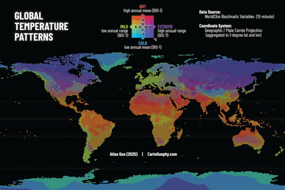
#30DayMapChallenge | Day 10 Air | This is an exploratory bivariate map illustrating global temperature patterns based on WorldClim bioclimatic variables: annual mean temperature (BIO-1) and annual temperature range (BIO-7). Read more: cartoguophy.com/maps/global_...
November 10, 2025 at 3:42 PM
#30DayMapChallenge | Day 10 Air | This is an exploratory bivariate map illustrating global temperature patterns based on WorldClim bioclimatic variables: annual mean temperature (BIO-1) and annual temperature range (BIO-7). Read more: cartoguophy.com/maps/global_...
📊🗺️👀

The Australian Inland Mission's stunning cartographic work between 1922 and 1970. Link: attilabatorfy.substack.com/p/helping-th...


November 10, 2025 at 4:54 PM
📊🗺️👀
The Planet satellite image I made for the Autódromo José Carlos Pace (Interlagos) is still being used by Wikipedia!
en.wikipedia.org/wiki/Interla...
en.wikipedia.org/wiki/Interla...

November 9, 2025 at 9:52 PM
The Planet satellite image I made for the Autódromo José Carlos Pace (Interlagos) is still being used by Wikipedia!
en.wikipedia.org/wiki/Interla...
en.wikipedia.org/wiki/Interla...
Reposted by Robert Simmon

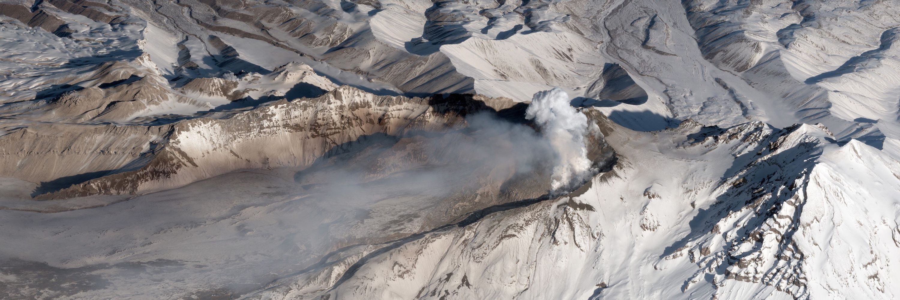
This same area had another sequence that started in 11/2002 that continued into 2/2003. That sequence included a bunch of M3+ events and a few M4’s just to the southeast (not included on this list below).
Data from ds.iris.edu/ieb/index.ht...
Data from ds.iris.edu/ieb/index.ht...

November 9, 2025 at 6:45 PM
This same area had another sequence that started in 11/2002 that continued into 2/2003. That sequence included a bunch of M3+ events and a few M4’s just to the southeast (not included on this list below).
Data from ds.iris.edu/ieb/index.ht...
Data from ds.iris.edu/ieb/index.ht...

Reposted by Robert Simmon

We at Esri look forward to seeing you at #AGU25, showcasing with our products & services not only how geospatial enables greater understanding of the world, but how we also perform good science as a member of the scientific community.
www.esri.com/arcgis-blog/...
🧪 🦑 🌊 🌎 🌍 🌏 ⚒️ #geogsky #geogchat
www.esri.com/arcgis-blog/...
🧪 🦑 🌊 🌎 🌍 🌏 ⚒️ #geogsky #geogchat

November 8, 2025 at 12:21 AM
We at Esri look forward to seeing you at #AGU25, showcasing with our products & services not only how geospatial enables greater understanding of the world, but how we also perform good science as a member of the scientific community.
www.esri.com/arcgis-blog/...
🧪 🦑 🌊 🌎 🌍 🌏 ⚒️ #geogsky #geogchat
www.esri.com/arcgis-blog/...
🧪 🦑 🌊 🌎 🌍 🌏 ⚒️ #geogsky #geogchat

TIL (via @mapsbyw.com ): @jscarto.bsky.social made a global basemap with NASA data: visibleearth.nasa.gov/images/14719...

November 7, 2025 at 6:33 PM
TIL (via @mapsbyw.com ): @jscarto.bsky.social made a global basemap with NASA data: visibleearth.nasa.gov/images/14719...
I just had to resolve a minor issue with the IRS, and the agent I worked with was fantastic, even during the shutdown!
November 7, 2025 at 6:15 PM
I just had to resolve a minor issue with the IRS, and the agent I worked with was fantastic, even during the shutdown!
Thoughts from Aravind Ravichandran as NASA (again) flirts with moving Earth observation to commercial data buys:
“Here is an underappreciated irony: commercial EO companies already depend on NASA's public infrastructure.”
newsletter.terrawatchspace.com/why-science-...
“Here is an underappreciated irony: commercial EO companies already depend on NASA's public infrastructure.”
newsletter.terrawatchspace.com/why-science-...

Why "Science-as-a-Service" Doesn't Work for Earth Science
There has been a lot of talk lately about whether commercial Earth observation (EO) companies could replace parts of NASA’s Earth science mission portfolio. With a new Administrator coming in, that de...
newsletter.terrawatchspace.com
November 7, 2025 at 5:43 PM
Thoughts from Aravind Ravichandran as NASA (again) flirts with moving Earth observation to commercial data buys:
“Here is an underappreciated irony: commercial EO companies already depend on NASA's public infrastructure.”
newsletter.terrawatchspace.com/why-science-...
“Here is an underappreciated irony: commercial EO companies already depend on NASA's public infrastructure.”
newsletter.terrawatchspace.com/why-science-...
Reposted by Robert Simmon

#30DayMapChallenge 7 Nov - Accessibility
This map shows the weather stations operated by the Spanish Met Service and regions where there is a lack of stations.
𝗧𝗵𝗲 𝗹𝗮𝗰𝗸 𝗼𝗳 𝘄𝗲𝗮𝘁𝗵𝗲𝗿 𝘀𝘁𝗮𝘁𝗶𝗼𝗻 𝗰𝗼𝘃𝗲𝗿𝗮𝗴𝗲 𝗹𝗶𝗺𝗶𝘁𝘀 𝘁𝗵𝗲 𝗮𝗯𝗶𝗹𝗶𝘁𝘆 𝘁𝗼 𝗱𝗲𝘁𝗲𝗰𝘁 𝗮𝗻𝗱 𝗮𝗻𝘁𝗶𝗰𝗶𝗽𝗮𝘁𝗲 𝗲𝘅𝘁𝗿𝗲𝗺𝗲 𝗲𝘃𝗲𝗻𝘁𝘀.
#aemet #geopandas #cartopy
This map shows the weather stations operated by the Spanish Met Service and regions where there is a lack of stations.
𝗧𝗵𝗲 𝗹𝗮𝗰𝗸 𝗼𝗳 𝘄𝗲𝗮𝘁𝗵𝗲𝗿 𝘀𝘁𝗮𝘁𝗶𝗼𝗻 𝗰𝗼𝘃𝗲𝗿𝗮𝗴𝗲 𝗹𝗶𝗺𝗶𝘁𝘀 𝘁𝗵𝗲 𝗮𝗯𝗶𝗹𝗶𝘁𝘆 𝘁𝗼 𝗱𝗲𝘁𝗲𝗰𝘁 𝗮𝗻𝗱 𝗮𝗻𝘁𝗶𝗰𝗶𝗽𝗮𝘁𝗲 𝗲𝘅𝘁𝗿𝗲𝗺𝗲 𝗲𝘃𝗲𝗻𝘁𝘀.
#aemet #geopandas #cartopy

November 7, 2025 at 8:57 AM
#30DayMapChallenge 7 Nov - Accessibility
This map shows the weather stations operated by the Spanish Met Service and regions where there is a lack of stations.
𝗧𝗵𝗲 𝗹𝗮𝗰𝗸 𝗼𝗳 𝘄𝗲𝗮𝘁𝗵𝗲𝗿 𝘀𝘁𝗮𝘁𝗶𝗼𝗻 𝗰𝗼𝘃𝗲𝗿𝗮𝗴𝗲 𝗹𝗶𝗺𝗶𝘁𝘀 𝘁𝗵𝗲 𝗮𝗯𝗶𝗹𝗶𝘁𝘆 𝘁𝗼 𝗱𝗲𝘁𝗲𝗰𝘁 𝗮𝗻𝗱 𝗮𝗻𝘁𝗶𝗰𝗶𝗽𝗮𝘁𝗲 𝗲𝘅𝘁𝗿𝗲𝗺𝗲 𝗲𝘃𝗲𝗻𝘁𝘀.
#aemet #geopandas #cartopy
This map shows the weather stations operated by the Spanish Met Service and regions where there is a lack of stations.
𝗧𝗵𝗲 𝗹𝗮𝗰𝗸 𝗼𝗳 𝘄𝗲𝗮𝘁𝗵𝗲𝗿 𝘀𝘁𝗮𝘁𝗶𝗼𝗻 𝗰𝗼𝘃𝗲𝗿𝗮𝗴𝗲 𝗹𝗶𝗺𝗶𝘁𝘀 𝘁𝗵𝗲 𝗮𝗯𝗶𝗹𝗶𝘁𝘆 𝘁𝗼 𝗱𝗲𝘁𝗲𝗰𝘁 𝗮𝗻𝗱 𝗮𝗻𝘁𝗶𝗰𝗶𝗽𝗮𝘁𝗲 𝗲𝘅𝘁𝗿𝗲𝗺𝗲 𝗲𝘃𝗲𝗻𝘁𝘀.
#aemet #geopandas #cartopy
Reposted by Robert Simmon

"It represents a substantial 59% increase over the previous mapping of 188,555 kilometres of Roman roads. This is a very significant expansion of our mapped knowledge of ancient infrastructure."
#History #Maps #Roads #Roman
#History #Maps #Roads #Roman

The Roman empire built 300,000 kilometres of roads: new study
A new comprehensive map reveals the true scale of the ancient Roman road network – but it is still incomplete.
theconversation.com
November 7, 2025 at 12:32 PM
Reposted by Robert Simmon

Computation+Journalism 2025 is a month away (December 11-12); we're finishing the last details of the symposium: cplusj2025.com Here's the full agenda: cplusj2025.com/agenda/ Join us! You can register here ($150 for professionals, $30 for students): events.miami.edu/event/cplusj...

November 6, 2025 at 4:24 PM
Computation+Journalism 2025 is a month away (December 11-12); we're finishing the last details of the symposium: cplusj2025.com Here's the full agenda: cplusj2025.com/agenda/ Join us! You can register here ($150 for professionals, $30 for students): events.miami.edu/event/cplusj...
Reposted by Robert Simmon
✅ edits from print proof
MAPS FOR KIDS coming soon.
MAPS FOR KIDS coming soon.

November 5, 2025 at 8:09 PM
✅ edits from print proof
MAPS FOR KIDS coming soon.
MAPS FOR KIDS coming soon.
Somehow I missed this BlackSky satellite image of Petra (as seen in Indiana Jones and the Last Crusade). From www.linkedin.com/feed/update/...

November 5, 2025 at 7:14 PM
Somehow I missed this BlackSky satellite image of Petra (as seen in Indiana Jones and the Last Crusade). From www.linkedin.com/feed/update/...