


Hourly Cosmos
@hourlycosmos.bsky.social
Photo sharing bot for planetary and deep space images.
Run by @kevinmgill.bsky.social
Content providers added with permission.
Run by @kevinmgill.bsky.social
Content providers added with permission.
ESP_022607_1725 - From UAHiRISE (NASA) (uahirise.bsky.social) - https://flic.kr/p/efdMrG

November 28, 2025 at 3:00 AM
ESP_022607_1725 - From UAHiRISE (NASA) (uahirise.bsky.social) - https://flic.kr/p/efdMrG
Plumes - From Gordan Ugarković (ugordan.bsky.social) - https://flic.kr/p/8wsQRV

November 28, 2025 at 2:00 AM
Plumes - From Gordan Ugarković (ugordan.bsky.social) - https://flic.kr/p/8wsQRV
Spiral Jetty - From Bill (ridingrobots.bsky.social) - https://flic.kr/p/2jFXcNV

November 28, 2025 at 1:00 AM
Spiral Jetty - From Bill (ridingrobots.bsky.social) - https://flic.kr/p/2jFXcNV
Opportunity 4-26-17 s4712 - From Jason Major (jpmajor.bsky.social) - https://flic.kr/p/29xkiRk

November 28, 2025 at 12:00 AM
Opportunity 4-26-17 s4712 - From Jason Major (jpmajor.bsky.social) - https://flic.kr/p/29xkiRk
Close-up with the Rosette Nebula (RGB Colour) - From Rolf Wahl Olsen - https://flic.kr/p/UYaQwE

November 27, 2025 at 11:00 PM
Close-up with the Rosette Nebula (RGB Colour) - From Rolf Wahl Olsen - https://flic.kr/p/UYaQwE
curiosity sol 44 mastcam R "Jake Matijevic" rock - From 2di7 & titanio44 - https://flic.kr/p/ddkRxG

November 27, 2025 at 10:01 PM
curiosity sol 44 mastcam R "Jake Matijevic" rock - From 2di7 & titanio44 - https://flic.kr/p/ddkRxG
CP18_37_21_1 - From Brian Swift (bswift.bsky.social) - https://flic.kr/p/24gPPre

November 27, 2025 at 9:00 PM
CP18_37_21_1 - From Brian Swift (bswift.bsky.social) - https://flic.kr/p/24gPPre
ESP_021523_1825 - From UAHiRISE (NASA) (uahirise.bsky.social) - https://flic.kr/p/ef3x73

November 27, 2025 at 8:01 PM
ESP_021523_1825 - From UAHiRISE (NASA) (uahirise.bsky.social) - https://flic.kr/p/ef3x73
Asteroid Itokawa closeup - From Gordan Ugarković (ugordan.bsky.social) - https://flic.kr/p/6ueXBb

November 27, 2025 at 7:00 PM
Asteroid Itokawa closeup - From Gordan Ugarković (ugordan.bsky.social) - https://flic.kr/p/6ueXBb
CP18_47_13_1 - From Brian Swift (bswift.bsky.social) - https://flic.kr/p/2eNGuhQ

November 27, 2025 at 6:00 PM
CP18_47_13_1 - From Brian Swift (bswift.bsky.social) - https://flic.kr/p/2eNGuhQ
Saturn-W00066643-Feb-25-RAW - From Ian Regan - https://flic.kr/p/9qzy4X

November 27, 2025 at 5:00 PM
Saturn-W00066643-Feb-25-RAW - From Ian Regan - https://flic.kr/p/9qzy4X
July 1 Titan Monitoring Campaign Observation - From Val Klavans (valklavans.bsky.social) - https://flic.kr/p/cqjKMs

November 27, 2025 at 4:00 PM
July 1 Titan Monitoring Campaign Observation - From Val Klavans (valklavans.bsky.social) - https://flic.kr/p/cqjKMs
Mars - The Rock of Love - Nasa's Curiosity SOL 3746 - From Andrea Luck (andrealuck.bsky.social) - https://flic.kr/p/2oi1fvh

November 27, 2025 at 3:00 PM
Mars - The Rock of Love - Nasa's Curiosity SOL 3746 - From Andrea Luck (andrealuck.bsky.social) - https://flic.kr/p/2oi1fvh
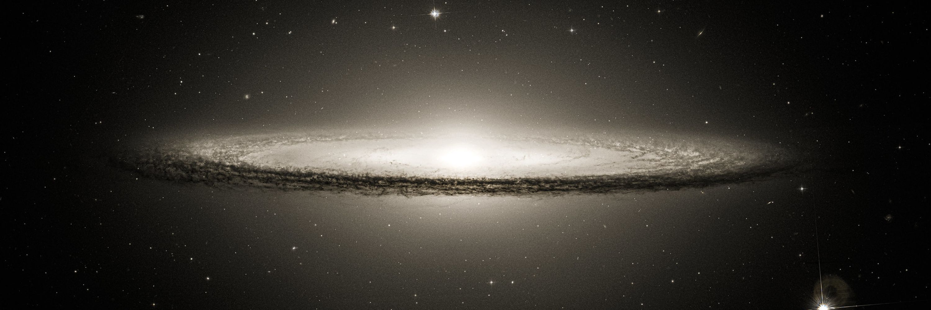
The relativistic jet of giant elliptical galaxy M87 - From Rolf Wahl Olsen - https://flic.kr/p/atvFrm

November 27, 2025 at 2:00 PM
The relativistic jet of giant elliptical galaxy M87 - From Rolf Wahl Olsen - https://flic.kr/p/atvFrm
moon and Jupiter - From Brian Swift (bswift.bsky.social) - https://flic.kr/p/dNGSX9

November 27, 2025 at 1:01 PM
moon and Jupiter - From Brian Swift (bswift.bsky.social) - https://flic.kr/p/dNGSX9
Perseverance Parachute Uplook Camera A - From Simeon Schmauß (stim3on.bsky.social) - https://flic.kr/p/2qMq1hb

November 27, 2025 at 12:00 PM
Perseverance Parachute Uplook Camera A - From Simeon Schmauß (stim3on.bsky.social) - https://flic.kr/p/2qMq1hb
Deimos before dawn | Perseverance Navcam Left | Sol 1433 - From Simeon Schmauß (stim3on.bsky.social) - https://flic.kr/p/2r6neAK

November 27, 2025 at 11:00 AM
Deimos before dawn | Perseverance Navcam Left | Sol 1433 - From Simeon Schmauß (stim3on.bsky.social) - https://flic.kr/p/2r6neAK
AM 0347-442 - From Judy Schmidt (geckzilla.bsky.social) - https://flic.kr/p/2g5BZFF

November 27, 2025 at 10:01 AM
AM 0347-442 - From Judy Schmidt (geckzilla.bsky.social) - https://flic.kr/p/2g5BZFF
The Vastness of the Dunes - From UAHiRISE (NASA) (uahirise.bsky.social) - https://flic.kr/p/2rC2F1c

November 27, 2025 at 9:00 AM
The Vastness of the Dunes - From UAHiRISE (NASA) (uahirise.bsky.social) - https://flic.kr/p/2rC2F1c
Circumpolar stars over the AAT - From Ángel López-Sánchez - https://flic.kr/p/e2dJPt

November 27, 2025 at 7:00 AM
Circumpolar stars over the AAT - From Ángel López-Sánchez - https://flic.kr/p/e2dJPt
Mimas & Unlit Rings - From Gordan Ugarković (ugordan.bsky.social) - https://flic.kr/p/boUiUT

November 27, 2025 at 5:00 AM
Mimas & Unlit Rings - From Gordan Ugarković (ugordan.bsky.social) - https://flic.kr/p/boUiUT
Saturn and Uranus using the FPI camera of 2dF @ 3.9m AAT - From Ángel López-Sánchez - https://flic.kr/p/cQiGHb

November 27, 2025 at 4:00 AM
Saturn and Uranus using the FPI camera of 2dF @ 3.9m AAT - From Ángel López-Sánchez - https://flic.kr/p/cQiGHb
SNR J0509.5-6731 - From Judy Schmidt (geckzilla.bsky.social) - https://flic.kr/p/2heTvq9

November 27, 2025 at 3:00 AM
SNR J0509.5-6731 - From Judy Schmidt (geckzilla.bsky.social) - https://flic.kr/p/2heTvq9
Candor and Ophir Chasmae 2015-07-19 - From Aster Cowart (terrasabaea.bsky.social) - https://flic.kr/p/LXVNxA

November 27, 2025 at 2:01 AM
Candor and Ophir Chasmae 2015-07-19 - From Aster Cowart (terrasabaea.bsky.social) - https://flic.kr/p/LXVNxA
The relativistic jet of giant elliptical galaxy M87 - From Rolf Wahl Olsen - https://flic.kr/p/atvFrm
November 27, 2025 at 12:00 AM
The relativistic jet of giant elliptical galaxy M87 - From Rolf Wahl Olsen - https://flic.kr/p/atvFrm