


James Holbeach🌀
@opplevelse.bsky.social
A fluid mechanist engineer specialising in multiphase flows with a passion for science, motorsport, satellite imagery, astro / space and weather, in particular Cyclones, typhoons, hurricanes! Based in Western Australia but travel the world!
Reposted by James Holbeach🌀
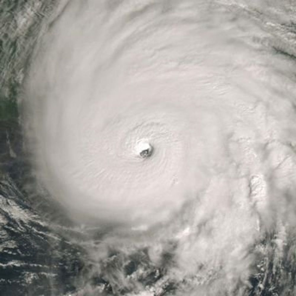
#OTDwx in 2006 Cyclone Bondo underwent a very impressive period of rapid intensification northeast of Madagascar. According to JTWC winds increased from 65 to 135 knots in 18 hours. During this time a pinhole eye (as small as ~8 nm) rapidly cleared and warmed to >15°C.
December 19, 2025 at 10:27 PM
#OTDwx in 2006 Cyclone Bondo underwent a very impressive period of rapid intensification northeast of Madagascar. According to JTWC winds increased from 65 to 135 knots in 18 hours. During this time a pinhole eye (as small as ~8 nm) rapidly cleared and warmed to >15°C.
Reposted by James Holbeach🌀
Way out west of the Cocos Islands, Cyclone #Bakung moved into the Australian AoR on the weekend as a tiny, yet potent cyclone- intensifying to a category 3. The 2nd of the season now.
A sign of yet another season with a high percentage of severe TC's coming up?
A sign of yet another season with a high percentage of severe TC's coming up?

December 16, 2025 at 5:11 AM
Way out west of the Cocos Islands, Cyclone #Bakung moved into the Australian AoR on the weekend as a tiny, yet potent cyclone- intensifying to a category 3. The 2nd of the season now.
A sign of yet another season with a high percentage of severe TC's coming up?
A sign of yet another season with a high percentage of severe TC's coming up?
Movie you’ve watched more than six times with a gif. Hard mode: no Stars (Wars nor Trek), LOTR, or Marvel, Disney Animated or Pixar.
December 8, 2025 at 12:20 AM
Movie you’ve watched more than six times with a gif. Hard mode: no Stars (Wars nor Trek), LOTR, or Marvel, Disney Animated or Pixar.
Reposted by James Holbeach🌀

Pffffft, that's nothing. Talk to me when it's at least a magnitude 1.36720235285300.

#Earthquake Update: A magnitude 1.36720235285299 earthquake took place 4 km N of View Park-Windsor Hills, CA at 7:41:20 PM. #micro
For details from the USGS:
For details from the USGS:
M 1.4 - 4 km N of View Park-Windsor Hills, CA | 41127255
2025-11-26 03:11:20 (UTC) | -118.344°N 34.030°W | 3.4 km depth
earthquake.usgs.gov
November 26, 2025 at 3:50 AM
Pffffft, that's nothing. Talk to me when it's at least a magnitude 1.36720235285300.
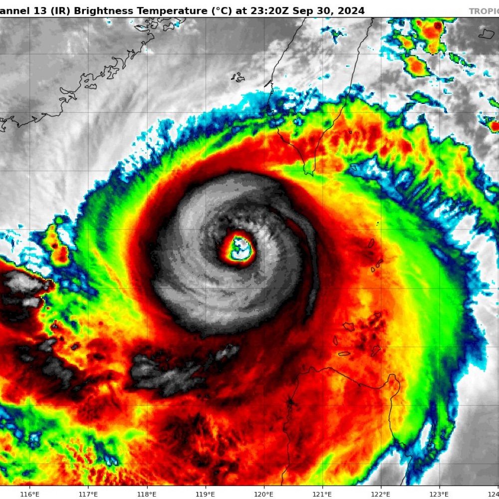
Lots of lightning around the eye of Severe Tropical Cyclone #Fina as it approaches the North Kimberly WA coast.
It is unusual to see this much lightning in such a strong system. Typically it indicates intensification in weaker systems. #CycloneFina #TCFina
It is unusual to see this much lightning in such a strong system. Typically it indicates intensification in weaker systems. #CycloneFina #TCFina
November 24, 2025 at 2:40 AM
Lots of lightning around the eye of Severe Tropical Cyclone #Fina as it approaches the North Kimberly WA coast.
It is unusual to see this much lightning in such a strong system. Typically it indicates intensification in weaker systems. #CycloneFina #TCFina
It is unusual to see this much lightning in such a strong system. Typically it indicates intensification in weaker systems. #CycloneFina #TCFina
A large burst of lightning to the NW of Tropical Cyclone Fina's circulation center also supports intensification. #TCFina #CycloneFina

November 21, 2025 at 12:50 AM
A large burst of lightning to the NW of Tropical Cyclone Fina's circulation center also supports intensification. #TCFina #CycloneFina
A significant convective flare from near the LLCC of #TCFina indicates intensification. I would not be surprised if it is back to Cat 2 (Aus scale) strength in the next bulletin.
Moisture good✅, SSTs warm✅, Shear low✅, Poleward outflow hampered❌ #CycloneFina #Fina #NT #AusWX
Moisture good✅, SSTs warm✅, Shear low✅, Poleward outflow hampered❌ #CycloneFina #Fina #NT #AusWX
November 21, 2025 at 12:31 AM
A significant convective flare from near the LLCC of #TCFina indicates intensification. I would not be surprised if it is back to Cat 2 (Aus scale) strength in the next bulletin.
Moisture good✅, SSTs warm✅, Shear low✅, Poleward outflow hampered❌ #CycloneFina #Fina #NT #AusWX
Moisture good✅, SSTs warm✅, Shear low✅, Poleward outflow hampered❌ #CycloneFina #Fina #NT #AusWX
Tropical #CycloneFina this morning, North east of the Tiwi Islands @50 kt sustained.
November 20, 2025 at 2:03 AM
Tropical #CycloneFina this morning, North east of the Tiwi Islands @50 kt sustained.
Tropical #CycloneFina over the last few hours showing a partially exposed LLCC in a dry slot between two blobs (technical term) of convective wet air.
November 19, 2025 at 2:21 AM
Tropical #CycloneFina over the last few hours showing a partially exposed LLCC in a dry slot between two blobs (technical term) of convective wet air.
Good morning Tropical Cyclone #Fina! #05S #02U. #CycloneFina A poorly organised cat 1 (Aus) system at the moment, with some banding, partially exposed LLCC, patchy moisture and poor convective structure.
Intensification predictions vary considerably, worth watching.
Intensification predictions vary considerably, worth watching.


November 19, 2025 at 1:49 AM
Good morning Tropical Cyclone #Fina! #05S #02U. #CycloneFina A poorly organised cat 1 (Aus) system at the moment, with some banding, partially exposed LLCC, patchy moisture and poor convective structure.
Intensification predictions vary considerably, worth watching.
Intensification predictions vary considerably, worth watching.
Nirvana's MTV Unplugged in New York. #OTD 32 years ago
One of the greatest live performances ever. Prove me wrong.
www.youtube.com/watch?v=pOTk...
Watch in memory of Kurt - RIP
One of the greatest live performances ever. Prove me wrong.
www.youtube.com/watch?v=pOTk...
Watch in memory of Kurt - RIP

Nirvana - MTV Unplugged in New York (4k Remastered)
YouTube video by Stephen Tures
www.youtube.com
November 18, 2025 at 3:10 AM
Nirvana's MTV Unplugged in New York. #OTD 32 years ago
One of the greatest live performances ever. Prove me wrong.
www.youtube.com/watch?v=pOTk...
Watch in memory of Kurt - RIP
One of the greatest live performances ever. Prove me wrong.
www.youtube.com/watch?v=pOTk...
Watch in memory of Kurt - RIP
Reposted by James Holbeach🌀
The first cyclone track map of the season is out with #02U #97S making landfall on Saturday AM on the Tiwi Islands as a category 2.
Due to its small size, there's significant intensity uncertainty. BOM technical report mentions a chance of category 3 intensity.
Next name is #Fina.
Due to its small size, there's significant intensity uncertainty. BOM technical report mentions a chance of category 3 intensity.
Next name is #Fina.

November 18, 2025 at 2:53 AM
A trough in the Indian Ocean south of Java is expected to slowly migrate Eastwards over the next few days and could develop into a tropical low early next week.
While the chance is low at the moment, it is the first I've noticed for this 25/26 season for Aus which is makes it newsworthy!
While the chance is low at the moment, it is the first I've noticed for this 25/26 season for Aus which is makes it newsworthy!
November 13, 2025 at 12:57 AM
A trough in the Indian Ocean south of Java is expected to slowly migrate Eastwards over the next few days and could develop into a tropical low early next week.
While the chance is low at the moment, it is the first I've noticed for this 25/26 season for Aus which is makes it newsworthy!
While the chance is low at the moment, it is the first I've noticed for this 25/26 season for Aus which is makes it newsworthy!
Reposted by James Holbeach🌀
The BOM is forecasting Tropical Low #02U to develop this weekend to the west of Darwin in the Timor Sea.
Currently only a 15% (low) chance of cyclonic development, but the forecast does mention “environmental conditions are supportive of significant development next week”.
Currently only a 15% (low) chance of cyclonic development, but the forecast does mention “environmental conditions are supportive of significant development next week”.

November 12, 2025 at 2:49 AM
The BOM is forecasting Tropical Low #02U to develop this weekend to the west of Darwin in the Timor Sea.
Currently only a 15% (low) chance of cyclonic development, but the forecast does mention “environmental conditions are supportive of significant development next week”.
Currently only a 15% (low) chance of cyclonic development, but the forecast does mention “environmental conditions are supportive of significant development next week”.
Reposted by James Holbeach🌀

Look guys I’ve spent the last day playing this over and over again. Don’t read the comments first and stick it through to the second verse. It is in fact one of the funniest things I’ve ever heard.

second verse on this is one of the funniest things i've ever heard
November 11, 2025 at 12:24 AM
Look guys I’ve spent the last day playing this over and over again. Don’t read the comments first and stick it through to the second verse. It is in fact one of the funniest things I’ve ever heard.
Reposted by James Holbeach🌀

Sunrise graces Tropical Storm Fung-Wong in the western Pacific Ocean.
Fung-Wong is forecast to undergo a period of rapid intensification soon as it heads westward towards the Philippines.
Fung-Wong is forecast to undergo a period of rapid intensification soon as it heads westward towards the Philippines.
November 6, 2025 at 11:41 PM
Sunrise graces Tropical Storm Fung-Wong in the western Pacific Ocean.
Fung-Wong is forecast to undergo a period of rapid intensification soon as it heads westward towards the Philippines.
Fung-Wong is forecast to undergo a period of rapid intensification soon as it heads westward towards the Philippines.
Reposted by James Holbeach🌀
#TD32W has become a large, sprawling tropical cyclone with lower shear and impressive upper divergence. Will be interesting to see the size of the inner core that forms from this. If on the smaller side, will lean towards stronger solutions. Something to keep an eye on this weekend in Luzon
November 5, 2025 at 10:22 PM
#TD32W has become a large, sprawling tropical cyclone with lower shear and impressive upper divergence. Will be interesting to see the size of the inner core that forms from this. If on the smaller side, will lean towards stronger solutions. Something to keep an eye on this weekend in Luzon
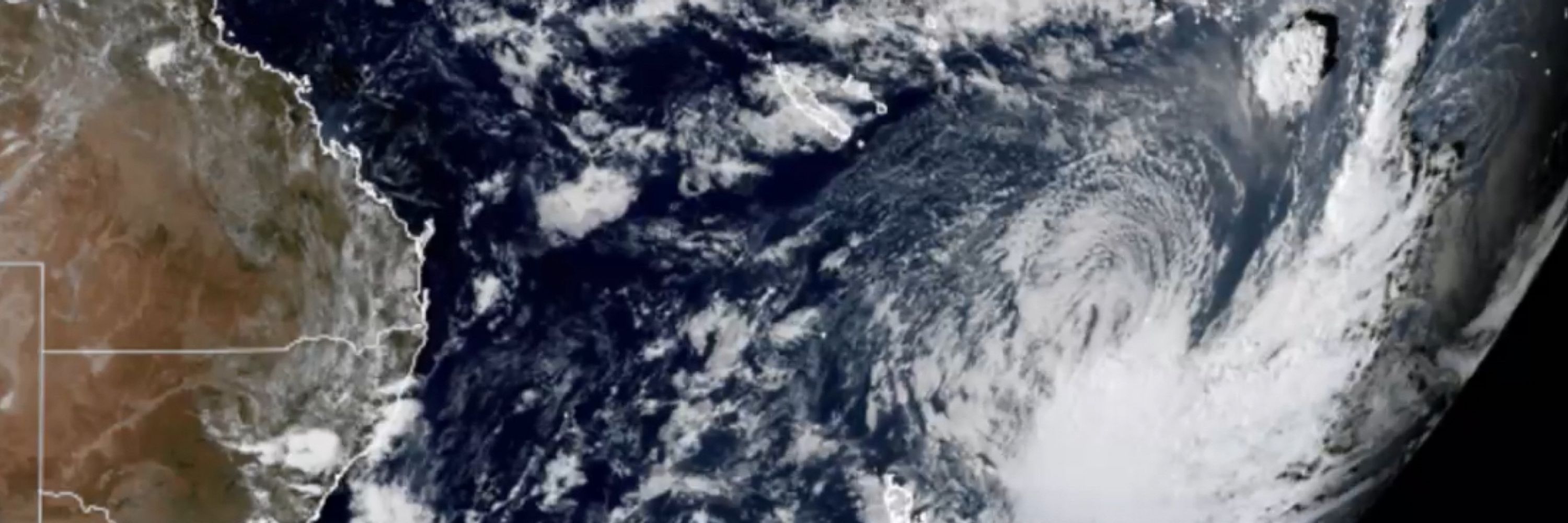
In this Himawarri satellite image from 08:10 WST this morning, a beautiful subtropical cutoff low approachs the Western Australia coast. 😍
It should cross the coast today near Kalbarri/ Geraldton. #WAWx #AustraliaWx
It should cross the coast today near Kalbarri/ Geraldton. #WAWx #AustraliaWx

November 5, 2025 at 12:53 AM
In this Himawarri satellite image from 08:10 WST this morning, a beautiful subtropical cutoff low approachs the Western Australia coast. 😍
It should cross the coast today near Kalbarri/ Geraldton. #WAWx #AustraliaWx
It should cross the coast today near Kalbarri/ Geraldton. #WAWx #AustraliaWx
Quite the little cut off low is expected to form off WA over the next few days! #WesternAustralia #AusWx #WAWx
November 3, 2025 at 3:01 AM
Quite the little cut off low is expected to form off WA over the next few days! #WesternAustralia #AusWx #WAWx
So let me be clear, this is art, it is not a real photo it is a composite… but it is also science if you read the description on how it was created. The thought and detail which went into it make it a fantastic fusion between the two!
Read the flickr link. 😄😲
Read the flickr link. 😄😲

The Magnificent Neptunian System - From Rolf Wahl Olsen - https://flic.kr/p/nix1x1

November 2, 2025 at 2:43 AM
So let me be clear, this is art, it is not a real photo it is a composite… but it is also science if you read the description on how it was created. The thought and detail which went into it make it a fantastic fusion between the two!
Read the flickr link. 😄😲
Read the flickr link. 😄😲
When you get bored and decide to calibrate the ADC on your ESP32 cos you don’t like the non linearly …


October 30, 2025 at 4:25 AM
When you get bored and decide to calibrate the ADC on your ESP32 cos you don’t like the non linearly …
Reposted by James Holbeach🌀

Alrighty, ready to see something really cool? (and maybe a little nauseating)
The evolution of Hurricane Melissa's mesovortices at peak strength.
The evolution of Hurricane Melissa's mesovortices at peak strength.
October 29, 2025 at 8:10 PM
Alrighty, ready to see something really cool? (and maybe a little nauseating)
The evolution of Hurricane Melissa's mesovortices at peak strength.
The evolution of Hurricane Melissa's mesovortices at peak strength.
Reposted by James Holbeach🌀

The Advanced Dvorak Technique (ADT) satellite-derived intensity estimate peaked at 185 knots for #Melissa -- which, according to the developer at CIMSS, is the highest value to date for any tropical cyclone.

October 28, 2025 at 10:41 PM
The Advanced Dvorak Technique (ADT) satellite-derived intensity estimate peaked at 185 knots for #Melissa -- which, according to the developer at CIMSS, is the highest value to date for any tropical cyclone.
Reposted by James Holbeach🌀

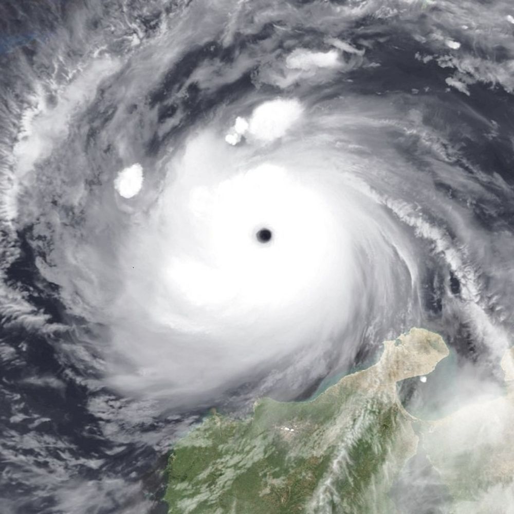
The eye of Hurricane Melissa.
Image taken today by Sentinel-2.
Image taken today by Sentinel-2.

October 28, 2025 at 7:22 PM
The eye of Hurricane Melissa.
Image taken today by Sentinel-2.
Image taken today by Sentinel-2.