


James Holbeach🌀
@opplevelse.bsky.social
A fluid mechanist engineer specialising in multiphase flows with a passion for science, motorsport, satellite imagery, astro / space and weather, in particular Cyclones, typhoons, hurricanes! Based in Western Australia but travel the world!
A number of fire scars are visible in the Northern Perth Hills area.
December 22, 2025 at 3:34 AM
A number of fire scars are visible in the Northern Perth Hills area.
Lightning caused a small bushfire in the Avin Valley National Park near Perth last week. This video is a comparison between 1 Dec and 21 Dec 2025 showing the fire scar. Top left is Avon River, Bottom right is Morangup subdivision.
Size is ~38Ha and uncomfortably close to my house!
#Bushfire #Perth
Size is ~38Ha and uncomfortably close to my house!
#Bushfire #Perth
December 21, 2025 at 11:33 PM
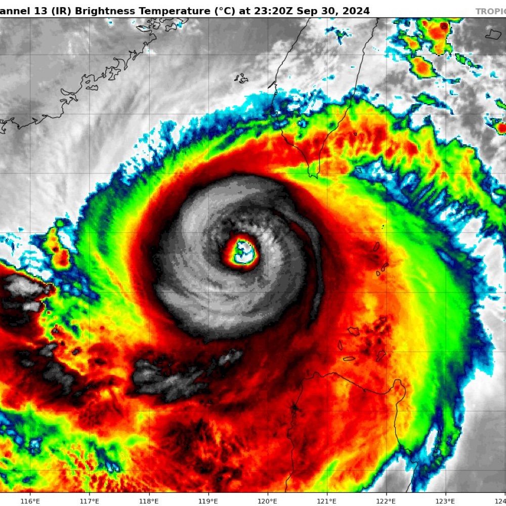
Lots of lightning around the eye of Severe Tropical Cyclone #Fina as it approaches the North Kimberly WA coast.
It is unusual to see this much lightning in such a strong system. Typically it indicates intensification in weaker systems. #CycloneFina #TCFina
It is unusual to see this much lightning in such a strong system. Typically it indicates intensification in weaker systems. #CycloneFina #TCFina
November 24, 2025 at 2:40 AM
Lots of lightning around the eye of Severe Tropical Cyclone #Fina as it approaches the North Kimberly WA coast.
It is unusual to see this much lightning in such a strong system. Typically it indicates intensification in weaker systems. #CycloneFina #TCFina
It is unusual to see this much lightning in such a strong system. Typically it indicates intensification in weaker systems. #CycloneFina #TCFina
A large burst of lightning to the NW of Tropical Cyclone Fina's circulation center also supports intensification. #TCFina #CycloneFina

November 21, 2025 at 12:50 AM
A large burst of lightning to the NW of Tropical Cyclone Fina's circulation center also supports intensification. #TCFina #CycloneFina
RGB and 640nm bands. On the loop you can see the overshooting tops of convection bubbling around the eye 😍 #CycloneFina #TCFina


November 21, 2025 at 12:38 AM
RGB and 640nm bands. On the loop you can see the overshooting tops of convection bubbling around the eye 😍 #CycloneFina #TCFina
A significant convective flare from near the LLCC of #TCFina indicates intensification. I would not be surprised if it is back to Cat 2 (Aus scale) strength in the next bulletin.
Moisture good✅, SSTs warm✅, Shear low✅, Poleward outflow hampered❌ #CycloneFina #Fina #NT #AusWX
Moisture good✅, SSTs warm✅, Shear low✅, Poleward outflow hampered❌ #CycloneFina #Fina #NT #AusWX
November 21, 2025 at 12:31 AM
A significant convective flare from near the LLCC of #TCFina indicates intensification. I would not be surprised if it is back to Cat 2 (Aus scale) strength in the next bulletin.
Moisture good✅, SSTs warm✅, Shear low✅, Poleward outflow hampered❌ #CycloneFina #Fina #NT #AusWX
Moisture good✅, SSTs warm✅, Shear low✅, Poleward outflow hampered❌ #CycloneFina #Fina #NT #AusWX
Latest MW image.
A small eye may be developing fully obscured by CDO, with lopsided convection to the N and NW of the LLCC. Still not pretty but looking more robust.
A small eye may be developing fully obscured by CDO, with lopsided convection to the N and NW of the LLCC. Still not pretty but looking more robust.

November 20, 2025 at 3:42 AM
Latest MW image.
A small eye may be developing fully obscured by CDO, with lopsided convection to the N and NW of the LLCC. Still not pretty but looking more robust.
A small eye may be developing fully obscured by CDO, with lopsided convection to the N and NW of the LLCC. Still not pretty but looking more robust.
Tropical #CycloneFina this morning, North east of the Tiwi Islands @50 kt sustained.
November 20, 2025 at 2:03 AM
Tropical #CycloneFina this morning, North east of the Tiwi Islands @50 kt sustained.
Tropical #CycloneFina over the last few hours showing a partially exposed LLCC in a dry slot between two blobs (technical term) of convective wet air.
November 19, 2025 at 2:21 AM
Tropical #CycloneFina over the last few hours showing a partially exposed LLCC in a dry slot between two blobs (technical term) of convective wet air.
#FIna is sitting over very warm waters, however, with low shear. If moisture can stay good and shear remain moderate, then conditions for intensification are favourable.
That little dry air slot is filling in ...
That little dry air slot is filling in ...


November 19, 2025 at 1:57 AM
#FIna is sitting over very warm waters, however, with low shear. If moisture can stay good and shear remain moderate, then conditions for intensification are favourable.
That little dry air slot is filling in ...
That little dry air slot is filling in ...
Good morning Tropical Cyclone #Fina! #05S #02U. #CycloneFina A poorly organised cat 1 (Aus) system at the moment, with some banding, partially exposed LLCC, patchy moisture and poor convective structure.
Intensification predictions vary considerably, worth watching.
Intensification predictions vary considerably, worth watching.


November 19, 2025 at 1:49 AM
Good morning Tropical Cyclone #Fina! #05S #02U. #CycloneFina A poorly organised cat 1 (Aus) system at the moment, with some banding, partially exposed LLCC, patchy moisture and poor convective structure.
Intensification predictions vary considerably, worth watching.
Intensification predictions vary considerably, worth watching.
A trough in the Indian Ocean south of Java is expected to slowly migrate Eastwards over the next few days and could develop into a tropical low early next week.
While the chance is low at the moment, it is the first I've noticed for this 25/26 season for Aus which is makes it newsworthy!
While the chance is low at the moment, it is the first I've noticed for this 25/26 season for Aus which is makes it newsworthy!
November 13, 2025 at 12:57 AM
A trough in the Indian Ocean south of Java is expected to slowly migrate Eastwards over the next few days and could develop into a tropical low early next week.
While the chance is low at the moment, it is the first I've noticed for this 25/26 season for Aus which is makes it newsworthy!
While the chance is low at the moment, it is the first I've noticed for this 25/26 season for Aus which is makes it newsworthy!
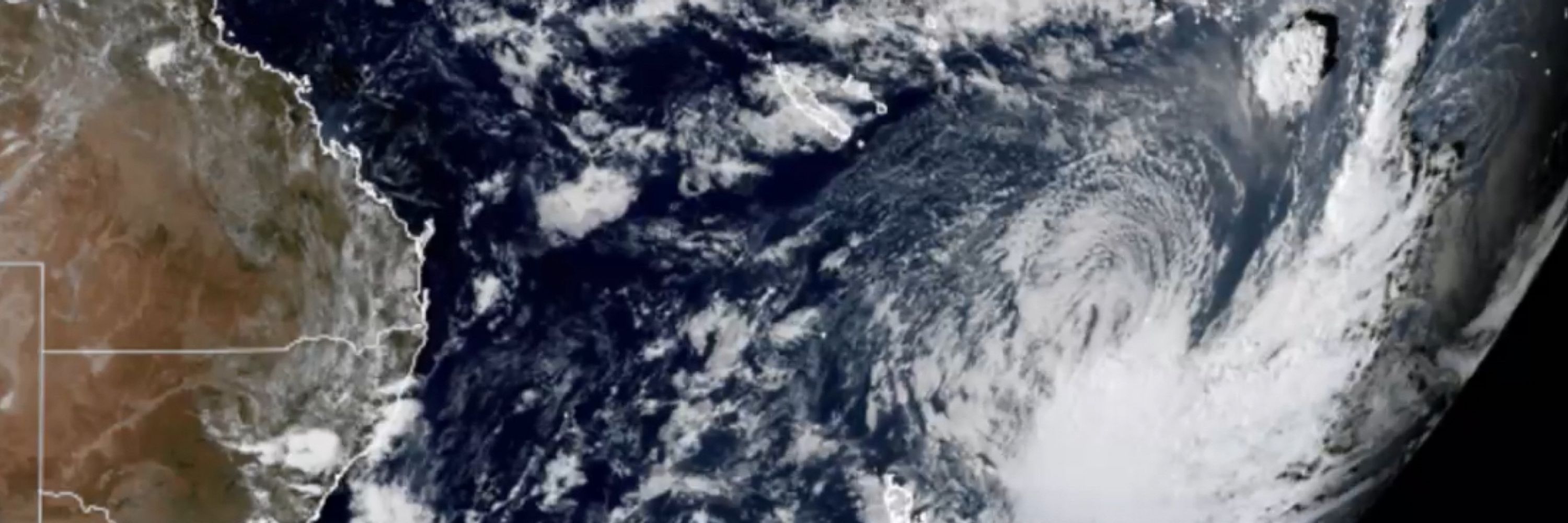
In this Himawarri satellite image from 08:10 WST this morning, a beautiful subtropical cutoff low approachs the Western Australia coast. 😍
It should cross the coast today near Kalbarri/ Geraldton. #WAWx #AustraliaWx
It should cross the coast today near Kalbarri/ Geraldton. #WAWx #AustraliaWx

November 5, 2025 at 12:53 AM
In this Himawarri satellite image from 08:10 WST this morning, a beautiful subtropical cutoff low approachs the Western Australia coast. 😍
It should cross the coast today near Kalbarri/ Geraldton. #WAWx #AustraliaWx
It should cross the coast today near Kalbarri/ Geraldton. #WAWx #AustraliaWx
Quite the little cut off low is expected to form off WA over the next few days! #WesternAustralia #AusWx #WAWx
November 3, 2025 at 3:01 AM
Quite the little cut off low is expected to form off WA over the next few days! #WesternAustralia #AusWx #WAWx
When you get bored and decide to calibrate the ADC on your ESP32 cos you don’t like the non linearly …


October 30, 2025 at 4:25 AM
When you get bored and decide to calibrate the ADC on your ESP32 cos you don’t like the non linearly …
Check out that poleward outflow. 😮
October 28, 2025 at 3:45 AM
Check out that poleward outflow. 😮

October 28, 2025 at 1:35 AM
2 years ago today Severe Tropical Cyclone Lola (01P 2023) was heading towards Vanuatu.
STC Lola was the strongest off season cyclone in the southern hemisphere. It peaked at 115 kt susustained (10min) maing it a Cat 5 (aus) / Cat 4 SS.
Tragically 4 people were killed and it caused >US$300M damage
STC Lola was the strongest off season cyclone in the southern hemisphere. It peaked at 115 kt susustained (10min) maing it a Cat 5 (aus) / Cat 4 SS.
Tragically 4 people were killed and it caused >US$300M damage
October 24, 2025 at 2:07 AM
2 years ago today Severe Tropical Cyclone Lola (01P 2023) was heading towards Vanuatu.
STC Lola was the strongest off season cyclone in the southern hemisphere. It peaked at 115 kt susustained (10min) maing it a Cat 5 (aus) / Cat 4 SS.
Tragically 4 people were killed and it caused >US$300M damage
STC Lola was the strongest off season cyclone in the southern hemisphere. It peaked at 115 kt susustained (10min) maing it a Cat 5 (aus) / Cat 4 SS.
Tragically 4 people were killed and it caused >US$300M damage
Case in point ...

October 24, 2025 at 12:33 AM
Case in point ...
Some of the hurricane specific models show a massive rain event for Jamaica & Cuba. This wobbly head-spinny one from HMON is a good example! #Melissa
October 24, 2025 at 12:27 AM
Some of the hurricane specific models show a massive rain event for Jamaica & Cuba. This wobbly head-spinny one from HMON is a good example! #Melissa
Tropical storm #Melissa weakened slightly.
Model tracks are more aligned than they were yesterday with almost all showing a sharp western recurve followed by a poleward one.
There is still considerable uncertainty in intensity. This is dependent on when (if any) rapid intensification occurs.
Model tracks are more aligned than they were yesterday with almost all showing a sharp western recurve followed by a poleward one.
There is still considerable uncertainty in intensity. This is dependent on when (if any) rapid intensification occurs.


October 24, 2025 at 12:27 AM
Tropical storm #Melissa weakened slightly.
Model tracks are more aligned than they were yesterday with almost all showing a sharp western recurve followed by a poleward one.
There is still considerable uncertainty in intensity. This is dependent on when (if any) rapid intensification occurs.
Model tracks are more aligned than they were yesterday with almost all showing a sharp western recurve followed by a poleward one.
There is still considerable uncertainty in intensity. This is dependent on when (if any) rapid intensification occurs.
🌀This bubbling mess that is Tropical Storm Melissa could develop into a major hurricane in the coming days.
It is predicted to be very slow moving dumping enormous quantities of rain over the Caribbean. #Watching
It is predicted to be very slow moving dumping enormous quantities of rain over the Caribbean. #Watching
October 23, 2025 at 4:08 AM
🌀This bubbling mess that is Tropical Storm Melissa could develop into a major hurricane in the coming days.
It is predicted to be very slow moving dumping enormous quantities of rain over the Caribbean. #Watching
It is predicted to be very slow moving dumping enormous quantities of rain over the Caribbean. #Watching
Magnificent shear tilted Cb producing clear air virga over Patong Beach this afternoon.
God I love the convection in the tropics!
God I love the convection in the tropics!

October 2, 2025 at 8:08 AM
Magnificent shear tilted Cb producing clear air virga over Patong Beach this afternoon.
God I love the convection in the tropics!
God I love the convection in the tropics!
