


James Holbeach🌀
@opplevelse.bsky.social
A fluid mechanist engineer specialising in multiphase flows with a passion for science, motorsport, satellite imagery, astro / space and weather, in particular Cyclones, typhoons, hurricanes! Based in Western Australia but travel the world!
Lots of lightning around the eye of Severe Tropical Cyclone #Fina as it approaches the North Kimberly WA coast.
It is unusual to see this much lightning in such a strong system. Typically it indicates intensification in weaker systems. #CycloneFina #TCFina
It is unusual to see this much lightning in such a strong system. Typically it indicates intensification in weaker systems. #CycloneFina #TCFina
November 24, 2025 at 2:40 AM
Lots of lightning around the eye of Severe Tropical Cyclone #Fina as it approaches the North Kimberly WA coast.
It is unusual to see this much lightning in such a strong system. Typically it indicates intensification in weaker systems. #CycloneFina #TCFina
It is unusual to see this much lightning in such a strong system. Typically it indicates intensification in weaker systems. #CycloneFina #TCFina
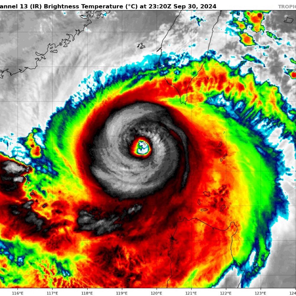
A significant convective flare from near the LLCC of #TCFina indicates intensification. I would not be surprised if it is back to Cat 2 (Aus scale) strength in the next bulletin.
Moisture good✅, SSTs warm✅, Shear low✅, Poleward outflow hampered❌ #CycloneFina #Fina #NT #AusWX
Moisture good✅, SSTs warm✅, Shear low✅, Poleward outflow hampered❌ #CycloneFina #Fina #NT #AusWX
November 21, 2025 at 12:31 AM
A significant convective flare from near the LLCC of #TCFina indicates intensification. I would not be surprised if it is back to Cat 2 (Aus scale) strength in the next bulletin.
Moisture good✅, SSTs warm✅, Shear low✅, Poleward outflow hampered❌ #CycloneFina #Fina #NT #AusWX
Moisture good✅, SSTs warm✅, Shear low✅, Poleward outflow hampered❌ #CycloneFina #Fina #NT #AusWX
Tropical #CycloneFina this morning, North east of the Tiwi Islands @50 kt sustained.
November 20, 2025 at 2:03 AM
Tropical #CycloneFina this morning, North east of the Tiwi Islands @50 kt sustained.
Tropical #CycloneFina over the last few hours showing a partially exposed LLCC in a dry slot between two blobs (technical term) of convective wet air.
November 19, 2025 at 2:21 AM
Tropical #CycloneFina over the last few hours showing a partially exposed LLCC in a dry slot between two blobs (technical term) of convective wet air.
A trough in the Indian Ocean south of Java is expected to slowly migrate Eastwards over the next few days and could develop into a tropical low early next week.
While the chance is low at the moment, it is the first I've noticed for this 25/26 season for Aus which is makes it newsworthy!
While the chance is low at the moment, it is the first I've noticed for this 25/26 season for Aus which is makes it newsworthy!
November 13, 2025 at 12:57 AM
A trough in the Indian Ocean south of Java is expected to slowly migrate Eastwards over the next few days and could develop into a tropical low early next week.
While the chance is low at the moment, it is the first I've noticed for this 25/26 season for Aus which is makes it newsworthy!
While the chance is low at the moment, it is the first I've noticed for this 25/26 season for Aus which is makes it newsworthy!
Quite the little cut off low is expected to form off WA over the next few days! #WesternAustralia #AusWx #WAWx
November 3, 2025 at 3:01 AM
Quite the little cut off low is expected to form off WA over the next few days! #WesternAustralia #AusWx #WAWx
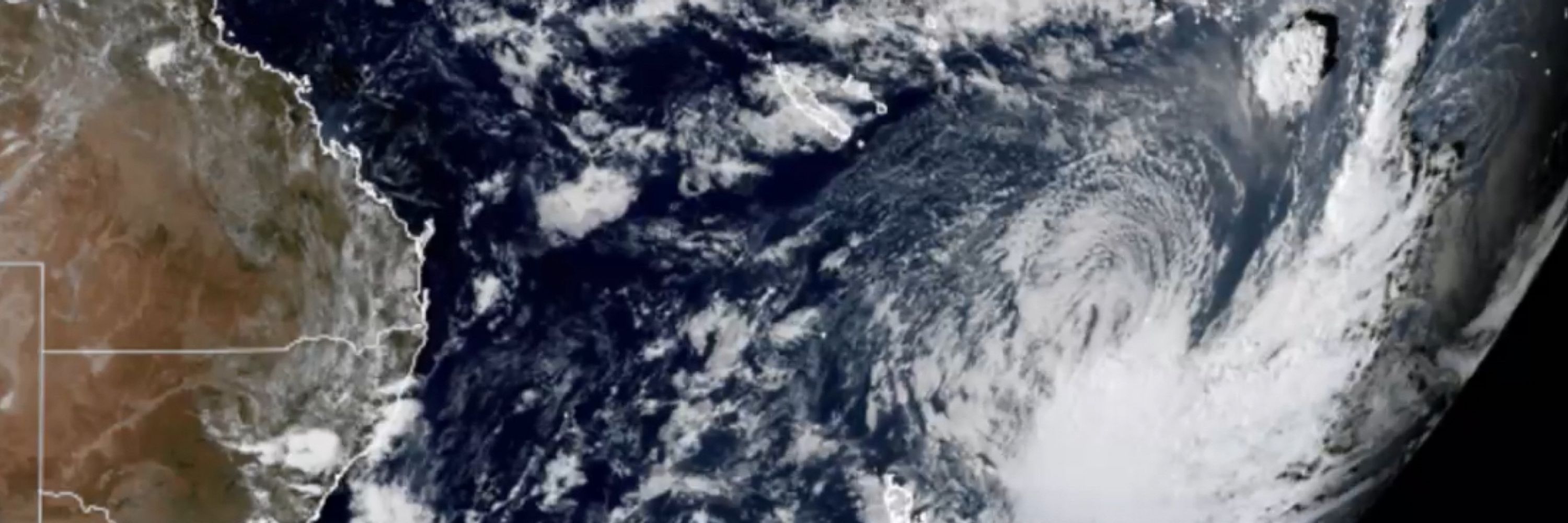
Check out that poleward outflow. 😮
October 28, 2025 at 3:45 AM
Check out that poleward outflow. 😮
2 years ago today Severe Tropical Cyclone Lola (01P 2023) was heading towards Vanuatu.
STC Lola was the strongest off season cyclone in the southern hemisphere. It peaked at 115 kt susustained (10min) maing it a Cat 5 (aus) / Cat 4 SS.
Tragically 4 people were killed and it caused >US$300M damage
STC Lola was the strongest off season cyclone in the southern hemisphere. It peaked at 115 kt susustained (10min) maing it a Cat 5 (aus) / Cat 4 SS.
Tragically 4 people were killed and it caused >US$300M damage
October 24, 2025 at 2:07 AM
2 years ago today Severe Tropical Cyclone Lola (01P 2023) was heading towards Vanuatu.
STC Lola was the strongest off season cyclone in the southern hemisphere. It peaked at 115 kt susustained (10min) maing it a Cat 5 (aus) / Cat 4 SS.
Tragically 4 people were killed and it caused >US$300M damage
STC Lola was the strongest off season cyclone in the southern hemisphere. It peaked at 115 kt susustained (10min) maing it a Cat 5 (aus) / Cat 4 SS.
Tragically 4 people were killed and it caused >US$300M damage
Some of the hurricane specific models show a massive rain event for Jamaica & Cuba. This wobbly head-spinny one from HMON is a good example! #Melissa
October 24, 2025 at 12:27 AM
Some of the hurricane specific models show a massive rain event for Jamaica & Cuba. This wobbly head-spinny one from HMON is a good example! #Melissa
🌀This bubbling mess that is Tropical Storm Melissa could develop into a major hurricane in the coming days.
It is predicted to be very slow moving dumping enormous quantities of rain over the Caribbean. #Watching
It is predicted to be very slow moving dumping enormous quantities of rain over the Caribbean. #Watching
October 23, 2025 at 4:08 AM
🌀This bubbling mess that is Tropical Storm Melissa could develop into a major hurricane in the coming days.
It is predicted to be very slow moving dumping enormous quantities of rain over the Caribbean. #Watching
It is predicted to be very slow moving dumping enormous quantities of rain over the Caribbean. #Watching
A lovely little low pressure system, leaving a cold pool of open cell convection in its wake, slipped to the South West of Western Australia this morning. 😍
September 6, 2025 at 5:04 AM
A lovely little low pressure system, leaving a cold pool of open cell convection in its wake, slipped to the South West of Western Australia this morning. 😍