
shamnadoes
@shamnadoes.bsky.social
Lead Forecaster at @NWSNashville 🔜 @NWSFortWorth. Tornadoes & #shamnadoes are my thing. All views are mine & not @NWS.
Reposted by shamnadoes

Dang…384 hour run of the 12Z GFS is rain free for DFW…
Wonder if the drier trend relates to warmer temps…warmest Nov is 63.5 F set in 2016.
Wonder if the drier trend relates to warmer temps…warmest Nov is 63.5 F set in 2016.
November 3, 2025 at 7:05 PM
Dang…384 hour run of the 12Z GFS is rain free for DFW…
Wonder if the drier trend relates to warmer temps…warmest Nov is 63.5 F set in 2016.
Wonder if the drier trend relates to warmer temps…warmest Nov is 63.5 F set in 2016.
Reposted by shamnadoes

I was worried for my crew mates when I saw them circling in the eye for over 20 mins. Looks like the very rough ride was confirmed. Plane had to leave early. They reported svr turb and a "sawtooth" eye. Looks like they moved 600-700ft up & down during this stretch in ~1 min.


October 28, 2025 at 4:23 PM
I was worried for my crew mates when I saw them circling in the eye for over 20 mins. Looks like the very rough ride was confirmed. Plane had to leave early. They reported svr turb and a "sawtooth" eye. Looks like they moved 600-700ft up & down during this stretch in ~1 min.
Reposted by shamnadoes

This meso loop of #Melissa from CIRA is absolutely stunning at it makes its closes in on landfall in southwestern Jamaica.
rammb-data.cira.colostate.edu/tc_realtime/...
#hurricanemelissa
rammb-data.cira.colostate.edu/tc_realtime/...
#hurricanemelissa
October 28, 2025 at 12:52 PM
This meso loop of #Melissa from CIRA is absolutely stunning at it makes its closes in on landfall in southwestern Jamaica.
rammb-data.cira.colostate.edu/tc_realtime/...
#hurricanemelissa
rammb-data.cira.colostate.edu/tc_realtime/...
#hurricanemelissa
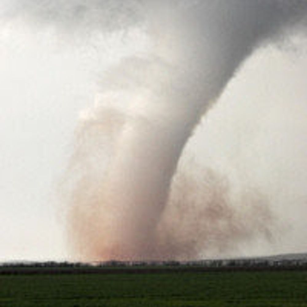
I think I’ll post a tornado I’ve seen per day until this crap ends or I run out of tornadoes. Since I’m 12 days behind, here’s some of the 12 tornadoes I saw on my best stormchase ever way back on May 29, 2004

October 13, 2025 at 2:56 AM
I think I’ll post a tornado I’ve seen per day until this crap ends or I run out of tornadoes. Since I’m 12 days behind, here’s some of the 12 tornadoes I saw on my best stormchase ever way back on May 29, 2004
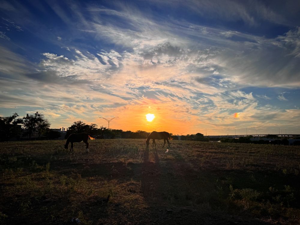
Sundogs and sunsets at work
October 11, 2025 at 11:46 PM
Sundogs and sunsets at work
“If you want the rainbow, you gotta put up with the rain” -Dolly Parton

September 15, 2025 at 11:03 PM
“If you want the rainbow, you gotta put up with the rain” -Dolly Parton
Reposted by shamnadoes
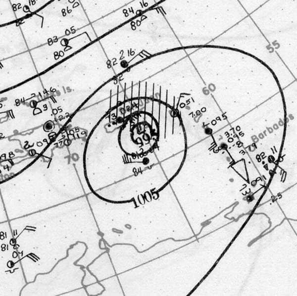
September 13, 1944:
USS Warrington, a Somers-class destroyer, sank east of the Bahamas. The culprit was the Great Atlantic Hurricane, a powerful Category 4 that peaked on the 13th. Nearly 250 members of the ship's crew were lost.
USS Warrington, a Somers-class destroyer, sank east of the Bahamas. The culprit was the Great Atlantic Hurricane, a powerful Category 4 that peaked on the 13th. Nearly 250 members of the ship's crew were lost.


September 13, 2025 at 4:26 PM
September 13, 1944:
USS Warrington, a Somers-class destroyer, sank east of the Bahamas. The culprit was the Great Atlantic Hurricane, a powerful Category 4 that peaked on the 13th. Nearly 250 members of the ship's crew were lost.
USS Warrington, a Somers-class destroyer, sank east of the Bahamas. The culprit was the Great Atlantic Hurricane, a powerful Category 4 that peaked on the 13th. Nearly 250 members of the ship's crew were lost.
Reposted by shamnadoes
September 13, 1928:
Puerto Rico was slammed by a Category 5 hurricane. The storm was reported to have damaged or destroyed over 200,000 structures. Massive amounts of crops were destroyed, heavily damaging the island's export industry. Over 300 people were killed.
Puerto Rico was slammed by a Category 5 hurricane. The storm was reported to have damaged or destroyed over 200,000 structures. Massive amounts of crops were destroyed, heavily damaging the island's export industry. Over 300 people were killed.


September 13, 2025 at 2:03 PM
September 13, 1928:
Puerto Rico was slammed by a Category 5 hurricane. The storm was reported to have damaged or destroyed over 200,000 structures. Massive amounts of crops were destroyed, heavily damaging the island's export industry. Over 300 people were killed.
Puerto Rico was slammed by a Category 5 hurricane. The storm was reported to have damaged or destroyed over 200,000 structures. Massive amounts of crops were destroyed, heavily damaging the island's export industry. Over 300 people were killed.
Reposted by shamnadoes

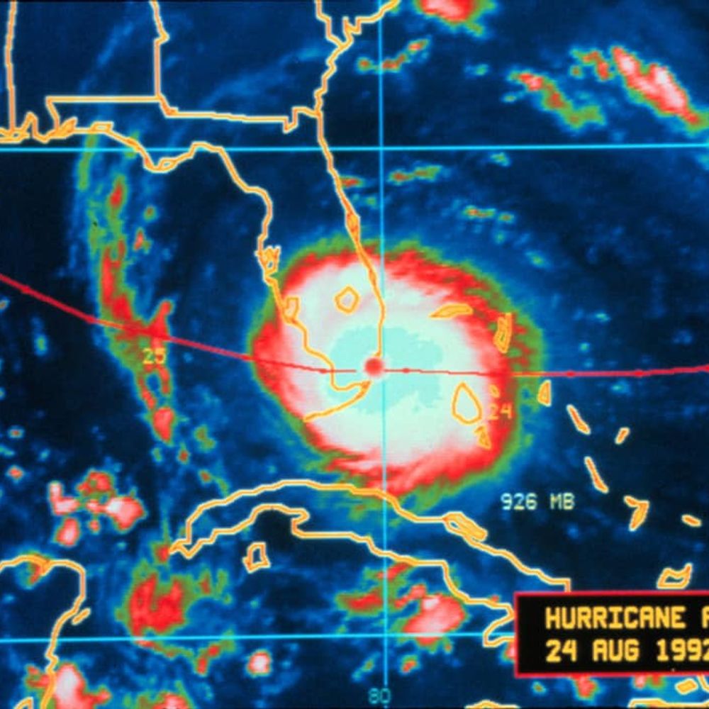
This radar loop of Hurricane #Katrina in 2005 spans August 28 at noon (CDT) through the morning of the 29th at 8:54am when communication with the radar was lost.
August 28, 2025 at 11:07 PM
This radar loop of Hurricane #Katrina in 2005 spans August 28 at noon (CDT) through the morning of the 29th at 8:54am when communication with the radar was lost.
Reposted by shamnadoes
August 25th, 2017:
Hurricane Harvey made landfall at ~10 PM near Rockport, Texas. It was the strongest hurricane to impact America since Wilma in 2005. The Category 4 left behind a record $125 billion in damage (tied with Katrina) and killed 106 people in the United States.
1/2
Hurricane Harvey made landfall at ~10 PM near Rockport, Texas. It was the strongest hurricane to impact America since Wilma in 2005. The Category 4 left behind a record $125 billion in damage (tied with Katrina) and killed 106 people in the United States.
1/2


August 25, 2025 at 1:52 PM
August 25th, 2017:
Hurricane Harvey made landfall at ~10 PM near Rockport, Texas. It was the strongest hurricane to impact America since Wilma in 2005. The Category 4 left behind a record $125 billion in damage (tied with Katrina) and killed 106 people in the United States.
1/2
Hurricane Harvey made landfall at ~10 PM near Rockport, Texas. It was the strongest hurricane to impact America since Wilma in 2005. The Category 4 left behind a record $125 billion in damage (tied with Katrina) and killed 106 people in the United States.
1/2


Reposted by shamnadoes
August 4th, 1980:
A record forty-two consecutive days of 100° heat finally came to an end at the Dallas-Fort Worth Airport on this day. July 1980 proved to be the hottest July on record with a mean temperature of 92 degrees.
A record forty-two consecutive days of 100° heat finally came to an end at the Dallas-Fort Worth Airport on this day. July 1980 proved to be the hottest July on record with a mean temperature of 92 degrees.
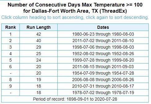
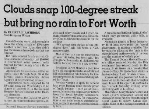
August 4, 2025 at 2:00 PM
August 4th, 1980:
A record forty-two consecutive days of 100° heat finally came to an end at the Dallas-Fort Worth Airport on this day. July 1980 proved to be the hottest July on record with a mean temperature of 92 degrees.
A record forty-two consecutive days of 100° heat finally came to an end at the Dallas-Fort Worth Airport on this day. July 1980 proved to be the hottest July on record with a mean temperature of 92 degrees.
Reposted by shamnadoes

Yesterday, Doha, Qatar, reported 90F, with a dew point of 90F, which gave a relative humidity of 100% and a heat index of 129F.
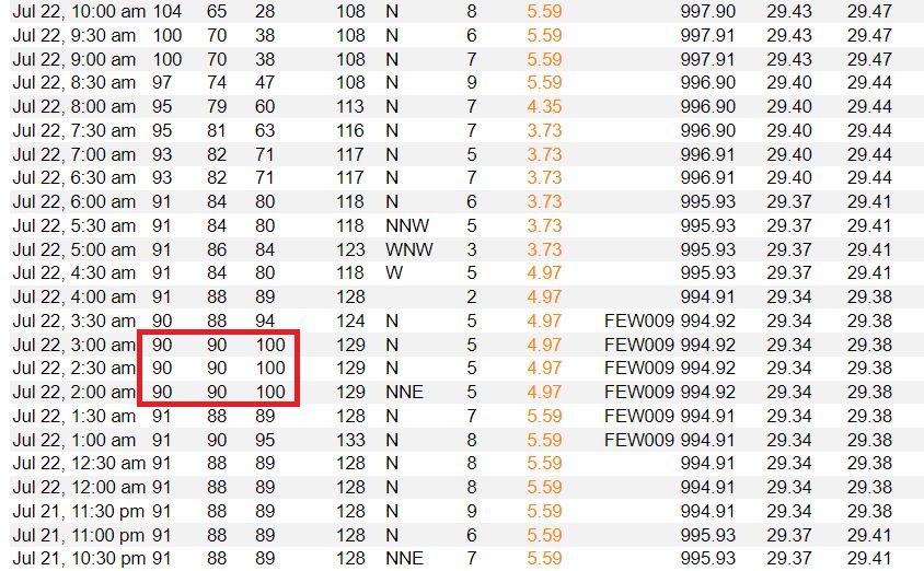
July 23, 2025 at 5:00 PM
Yesterday, Doha, Qatar, reported 90F, with a dew point of 90F, which gave a relative humidity of 100% and a heat index of 129F.
Reposted by shamnadoes

There’s something you don’t see every day — an MCV moving east to west into California towards the Death Valley region:
July 18, 2025 at 1:48 PM
There’s something you don’t see every day — an MCV moving east to west into California towards the Death Valley region:
Reposted by shamnadoes

Another issue here is mismatch between public expectation & scientific reality re: what's possible in predicting localized convective extremes (i.e., severe/torrential t-storms). Days/environments supportive of such risk are predictable; exact timing/location/intensity of subsequent extremes is not.
There have been claims that NOAA/NWS did not foresee catastrophic TX floods--but that's simply not true. This was undoubtedly an extreme event, but messaging rapidly escalated beginning ~12 hrs prior. Flood Watch mid PM, "heads up" outlook late PM, flash flood warnings ~1am.
WPC issued as many as six MPDs for the deadly flash flooding in the TX Hill Country starting yesterday evening and lasting through much of today. The first MPD generally set the stage for what was to come, while the next three shown were as the event unfolded.
July 5, 2025 at 9:54 PM
Another issue here is mismatch between public expectation & scientific reality re: what's possible in predicting localized convective extremes (i.e., severe/torrential t-storms). Days/environments supportive of such risk are predictable; exact timing/location/intensity of subsequent extremes is not.
Reposted by shamnadoes
The Texas floods over the last 2 days were predominantly associated with a long-lasting mesoscale convective vortex (MCV), but notice how there are multiple discrete rainfall maxima shown in the contours, each associated with different rainfall rates, duration, and phenomenon:
July 6, 2025 at 2:30 AM
The Texas floods over the last 2 days were predominantly associated with a long-lasting mesoscale convective vortex (MCV), but notice how there are multiple discrete rainfall maxima shown in the contours, each associated with different rainfall rates, duration, and phenomenon:
What a night working radar/warning ops for NWS Norman during their AWIPS upgrade ⛈️ I ended up issuing 17 svr tstorm warnings and 5 tornado warnings across Oklahoma 😮 Quite a fascinating supercell/QLCS event. Sorry to my Norman friends for setting off the sirens/phones and waking you up 🫤
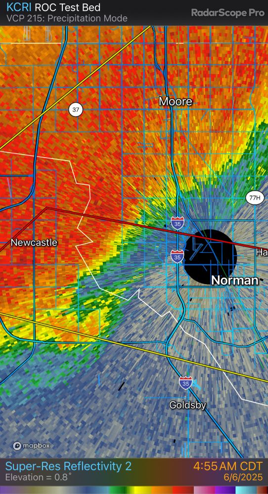
June 6, 2025 at 12:28 PM
What a night working radar/warning ops for NWS Norman during their AWIPS upgrade ⛈️ I ended up issuing 17 svr tstorm warnings and 5 tornado warnings across Oklahoma 😮 Quite a fascinating supercell/QLCS event. Sorry to my Norman friends for setting off the sirens/phones and waking you up 🫤
Reposted by shamnadoes

Inside of an EF1-rated tornado and severe thunderstorm winds near Willard, CO on May 23. Watch the full video here: youtu.be/nRc38pZ0E5s
May 29, 2025 at 2:34 AM
Inside of an EF1-rated tornado and severe thunderstorm winds near Willard, CO on May 23. Watch the full video here: youtu.be/nRc38pZ0E5s
Reposted by shamnadoes

International Falls, MN hit 95 today. They hit 95 this year before Memphis, Dallas, Houston, Atlanta, Charlotte, Little Rock, and New Orleans. They now have as many 95 degree days through May 11 as San Antonio, Austin, and El Paso.
May 11, 2025 at 11:55 PM
International Falls, MN hit 95 today. They hit 95 this year before Memphis, Dallas, Houston, Atlanta, Charlotte, Little Rock, and New Orleans. They now have as many 95 degree days through May 11 as San Antonio, Austin, and El Paso.
Reposted by shamnadoes

The Sacramento weather service office just sent an email detailing product changes amid "critically reduced staffing"
Highlights:
Phone lines no longer answered
Reduced staffing from 6pm to 6am
Forecast discussions issued only 1x/day
Limited social media posting
Advisories mainly issued by day shift
Highlights:
Phone lines no longer answered
Reduced staffing from 6pm to 6am
Forecast discussions issued only 1x/day
Limited social media posting
Advisories mainly issued by day shift
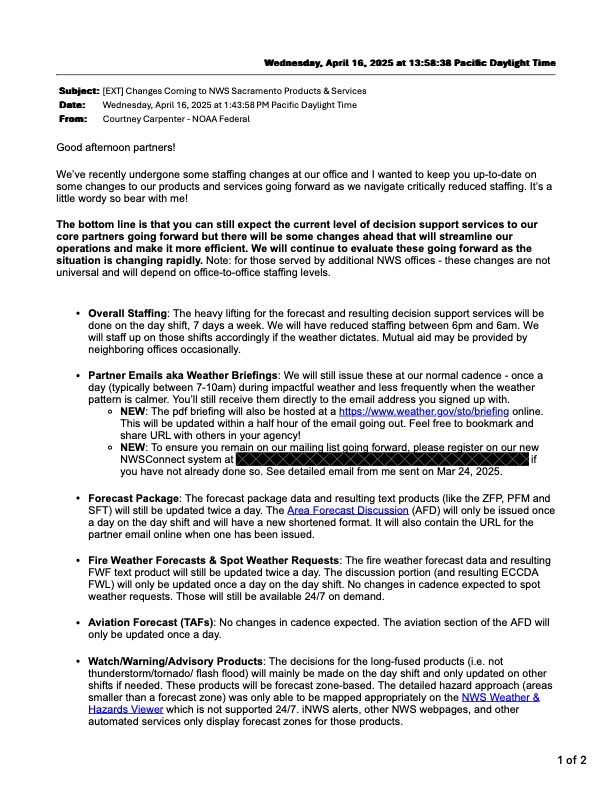
April 16, 2025 at 9:31 PM
The Sacramento weather service office just sent an email detailing product changes amid "critically reduced staffing"
Highlights:
Phone lines no longer answered
Reduced staffing from 6pm to 6am
Forecast discussions issued only 1x/day
Limited social media posting
Advisories mainly issued by day shift
Highlights:
Phone lines no longer answered
Reduced staffing from 6pm to 6am
Forecast discussions issued only 1x/day
Limited social media posting
Advisories mainly issued by day shift
Reposted by shamnadoes

Cisco,TX (GZN) ASOS reports gust of 54 knots (62.1 mph) from WSW @ 1045Z -- KGZN 031045Z AUTO 25041G54KT 10SM VCTS BKN019 OVC024 13/09 A2978 RMK AO2
April 3, 2025 at 11:05 AM
Cisco,TX (GZN) ASOS reports gust of 54 knots (62.1 mph) from WSW @ 1045Z -- KGZN 031045Z AUTO 25041G54KT 10SM VCTS BKN019 OVC024 13/09 A2978 RMK AO2
Reposted by shamnadoes