


Anthony Edwards
@edwardsanthonyb.bsky.social
Writing about West Coast weather as a Newsroom Meteorologist at the San Francisco Chronicle
Snow lover, Seattle sports fan, University of Washington graduate
sfchronicle.com/author/anthony-edwards/
Snow lover, Seattle sports fan, University of Washington graduate
sfchronicle.com/author/anthony-edwards/
Coldest November day in Sacramento since 1985 with a high temperature of just 48°F! #CAwx

SACRAMENTO EXEC AP AND CITY Nov 27 Climate: High: 48 Low: 45 Precip: 0.0" Snow: Missing Link

November 28, 2025 at 2:45 AM
Coldest November day in Sacramento since 1985 with a high temperature of just 48°F! #CAwx
Reposted by Anthony Edwards
California weather: Here’s what to expect for Thanksgiving weekend—Similar weather is on tap across California on Friday, but changes are in store Saturday and Sunday. The high-pressure system that has parked over… www.sfchronicle.com/weather-fore... @edwardsanthonyb.bsky.social @sfchronicle.com

California weather: Here’s what to expect for Thanksgiving weekend
It could be the warmest Thanksgiving in 30 years in parts of the state, while other California cities remain trapped beneath thick fog.
www.sfchronicle.com
November 27, 2025 at 3:40 PM
California weather: Here’s what to expect for Thanksgiving weekend—Similar weather is on tap across California on Friday, but changes are in store Saturday and Sunday. The high-pressure system that has parked over… www.sfchronicle.com/weather-fore... @edwardsanthonyb.bsky.social @sfchronicle.com
Tahoe City Thanksgiving forecast high temperature: 59ºF.
If it verifies, would be Tahoe City's warmest Thanksgiving in three decades and the warmest day this late in the year since 2017 (60ºF, Dec. 30).
Map shows forecast maximum temperature anomaly for Thursday, Nov. 27. #CAwx
If it verifies, would be Tahoe City's warmest Thanksgiving in three decades and the warmest day this late in the year since 2017 (60ºF, Dec. 30).
Map shows forecast maximum temperature anomaly for Thursday, Nov. 27. #CAwx

November 26, 2025 at 8:53 PM
Tahoe City Thanksgiving forecast high temperature: 59ºF.
If it verifies, would be Tahoe City's warmest Thanksgiving in three decades and the warmest day this late in the year since 2017 (60ºF, Dec. 30).
Map shows forecast maximum temperature anomaly for Thursday, Nov. 27. #CAwx
If it verifies, would be Tahoe City's warmest Thanksgiving in three decades and the warmest day this late in the year since 2017 (60ºF, Dec. 30).
Map shows forecast maximum temperature anomaly for Thursday, Nov. 27. #CAwx
Reposted by Anthony Edwards

@cw3eScripps is now accepting applications for its Summer 2026 undergraduate internship program! Paid & lodging provided, to work with world class weather, water, climate scientists in La Jolla, CA!
cw3e.ucsd.edu/cw3e-interns...
cw3e.ucsd.edu/cw3e-interns...

November 26, 2025 at 12:08 AM
@cw3eScripps is now accepting applications for its Summer 2026 undergraduate internship program! Paid & lodging provided, to work with world class weather, water, climate scientists in La Jolla, CA!
cw3e.ucsd.edu/cw3e-interns...
cw3e.ucsd.edu/cw3e-interns...
Reposted by Anthony Edwards
With OMB and Dept of the Interior leadership ignoring the law, whether we'll succeed is anybody's guess, but Americans deserve the science needed to build the resilience of the species and ecosystems that sustain us.
November 25, 2025 at 2:13 AM
With OMB and Dept of the Interior leadership ignoring the law, whether we'll succeed is anybody's guess, but Americans deserve the science needed to build the resilience of the species and ecosystems that sustain us.
America is going all-in on AI
www.aip.org/fyi/trump-ad...
www.aip.org/fyi/trump-ad...

Trump Administration Launches ‘Genesis Mission’ to Boost Science through AI
DOE will lead an AI effort that administration members are comparing in scale to the Manhattan Project and Apollo program.
www.aip.org
November 25, 2025 at 10:34 PM
America is going all-in on AI
www.aip.org/fyi/trump-ad...
www.aip.org/fyi/trump-ad...
Bay Area’s first Spare the Air alert of season to take effect just before Thanksgiving www.sfchronicle.com/weather/arti...

Bay Area’s first Spare the Air alert to take effect just before Thanksgiving
Smoggy skies across the Bay Area were forecast to continue through the holiday — meaniing that wood-burning fireplaces cannot be used over Thanksgiving.
www.sfchronicle.com
November 25, 2025 at 7:10 PM
Bay Area’s first Spare the Air alert of season to take effect just before Thanksgiving www.sfchronicle.com/weather/arti...
Places in red measured their lowest Nov. 24 snow depth on record. Some of the sites are low elevation and have many years of zero snow depth on this date, but there's a number of sites at higher elevation that should be covered in snow at this point.

November 25, 2025 at 6:03 PM
Places in red measured their lowest Nov. 24 snow depth on record. Some of the sites are low elevation and have many years of zero snow depth on this date, but there's a number of sites at higher elevation that should be covered in snow at this point.
Fog is even more widespread today (Tuesday, Nov. 25)!

November 25, 2025 at 4:59 PM
Fog is even more widespread today (Tuesday, Nov. 25)!
Lee Canyon, an hour west of Las Vegas, has received more snow than California’s Donner Pass so far this season. Arizona Snowbowl in Flagstaff, Ariz., is having its snowiest November since 2004, with nearly five feet of powder.

Tahoe and Colorado are mostly dry. Here’s where you can still ski out West
While many Tahoe ski resorts delay opening day, a surprising corner of the West has experienced its snowiest start to the season in decades.
www.sfchronicle.com
November 25, 2025 at 4:21 PM
Lee Canyon, an hour west of Las Vegas, has received more snow than California’s Donner Pass so far this season. Arizona Snowbowl in Flagstaff, Ariz., is having its snowiest November since 2004, with nearly five feet of powder.

‘Epic’: Salmon seen far upstream in Bay Area creek for first time in 70 years www.sfchronicle.com/bayarea/arti...

‘Epic’: Salmon seen far upstream in Bay Area creek for first time in 70 years
After the removal of small dams and the addition of fish ladders, salmon have been seen swimming further up a Bay Area creek than at anytime in decades.
www.sfchronicle.com
November 21, 2025 at 11:44 PM
‘Epic’: Salmon seen far upstream in Bay Area creek for first time in 70 years www.sfchronicle.com/bayarea/arti...
Weather pattern change to put CA in a precarious position post-Thanksgiving. Maps shows the "standard deviation" (spread) amongst weather models Dec. 1. There is more uncertainty about the atmospheric pattern over CA than anywhere else in the Northern Hemisphere! Could be cold/wet or less cold & dry


November 21, 2025 at 9:17 PM
Weather pattern change to put CA in a precarious position post-Thanksgiving. Maps shows the "standard deviation" (spread) amongst weather models Dec. 1. There is more uncertainty about the atmospheric pattern over CA than anywhere else in the Northern Hemisphere! Could be cold/wet or less cold & dry
Reposted by Anthony Edwards
Bay Area to dry out after stormy stretch—The Bay Area’s parade of November storms is finally coming to an end. This weekend will mark the beginning of a dry stretch… www.sfchronicle.com/weather-fore... @edwardsanthonyb.bsky.social @sfchronicle.com

Bay Area to dry out after stormy stretch
Seasonal temperatures are expected in the Bay Area this weekend, although valley fog may be hard to shake.
www.sfchronicle.com
November 21, 2025 at 2:27 PM
Bay Area to dry out after stormy stretch—The Bay Area’s parade of November storms is finally coming to an end. This weekend will mark the beginning of a dry stretch… www.sfchronicle.com/weather-fore... @edwardsanthonyb.bsky.social @sfchronicle.com
Impressive 24-hour precipitation totals in Southern California from the latest storm. Downtown Los Angeles (Dodger Stadium) picked up more than 2 inches of rain between 11 a.m. Thursday and 11 a.m. Friday.
L.A. has now received 5.52 inches of rain this month, the city's wettest November since 1967.
L.A. has now received 5.52 inches of rain this month, the city's wettest November since 1967.

November 21, 2025 at 8:19 PM
Impressive 24-hour precipitation totals in Southern California from the latest storm. Downtown Los Angeles (Dodger Stadium) picked up more than 2 inches of rain between 11 a.m. Thursday and 11 a.m. Friday.
L.A. has now received 5.52 inches of rain this month, the city's wettest November since 1967.
L.A. has now received 5.52 inches of rain this month, the city's wettest November since 1967.
Cloud appreciation post

November 21, 2025 at 12:31 AM
Cloud appreciation post
Reposted by Anthony Edwards

Adding this to me "mascots being detained" image folder.

November 20, 2025 at 3:48 PM
Adding this to me "mascots being detained" image folder.
It's going to be prime #TuleFog season in #California next week. Soil moisture >90th percentile across much of CA thanks to recent rain. Light winds with high-pressure system overhead will make for ideal conditions for radiation fog. Plan ahead if traveling through the valley for Thanksgiving. #CAwx


November 20, 2025 at 12:16 AM
It's going to be prime #TuleFog season in #California next week. Soil moisture >90th percentile across much of CA thanks to recent rain. Light winds with high-pressure system overhead will make for ideal conditions for radiation fog. Plan ahead if traveling through the valley for Thanksgiving. #CAwx
The San Francisco Bay Area is in for some light rainfall tonight from a weak system and showers should be winding down for most by sunrise Thursday
www.sfchronicle.com/weather-fore...
www.sfchronicle.com/weather-fore...

Another rainmaker is coming to California. Here’s where it’ll be wettest
The last in a series of wet weather systems is headed to California. It’ll help boost rainfall totals that are already running well ahead of normal.
www.sfchronicle.com
November 20, 2025 at 12:09 AM
The San Francisco Bay Area is in for some light rainfall tonight from a weak system and showers should be winding down for most by sunrise Thursday
www.sfchronicle.com/weather-fore...
www.sfchronicle.com/weather-fore...
Reposted by Anthony Edwards

A view of this year's extreme sea surface temperatures and recent warming across the North Pacific... 🌊
This graph shows the average for a band across the midlatitudes for every average January-October period from 1854-2025 using ERSSTv5 data.
This graph shows the average for a band across the midlatitudes for every average January-October period from 1854-2025 using ERSSTv5 data.

November 19, 2025 at 1:28 AM
A view of this year's extreme sea surface temperatures and recent warming across the North Pacific... 🌊
This graph shows the average for a band across the midlatitudes for every average January-October period from 1854-2025 using ERSSTv5 data.
This graph shows the average for a band across the midlatitudes for every average January-October period from 1854-2025 using ERSSTv5 data.
Two of Tahoe’s biggest ski resorts won't open on time www.sfchronicle.com/outdoors/art...

Two of Tahoe’s biggest ski resorts won't open on time
Lower-than-normal snowfall combined with warm temperatures has made it tough for Sierra ski areas hoping to open a week before Thanksgiving.
www.sfchronicle.com
November 19, 2025 at 10:43 PM
Two of Tahoe’s biggest ski resorts won't open on time www.sfchronicle.com/outdoors/art...
Reposted by Anthony Edwards
Kinda interesting to compare water year precipitation with snowpack at a continental scale. Most of the western US has been very wet since October 1, but there is almost no snowpack anywhere except at the very highest elevations because it has been so ridiculously warm. #hydrology #wx

November 18, 2025 at 11:18 PM
Kinda interesting to compare water year precipitation with snowpack at a continental scale. Most of the western US has been very wet since October 1, but there is almost no snowpack anywhere except at the very highest elevations because it has been so ridiculously warm. #hydrology #wx
A recent onslaught of storms pushed many of California’s creeks and streams to unusual territory and crushed rainfall records in other parts of the state.
The Merced River in Yosemite NP was flowing faster than any November in half of a century. Santa Barbara demolished a monthly rainfall record.
The Merced River in Yosemite NP was flowing faster than any November in half of a century. Santa Barbara demolished a monthly rainfall record.

Yosemite Valley’s main river hits November flow record after rain
A major California city also just got more November rain than anytime in a century as California's water totals are off to a strong start following storms.
www.sfchronicle.com
November 18, 2025 at 10:13 PM
A recent onslaught of storms pushed many of California’s creeks and streams to unusual territory and crushed rainfall records in other parts of the state.
The Merced River in Yosemite NP was flowing faster than any November in half of a century. Santa Barbara demolished a monthly rainfall record.
The Merced River in Yosemite NP was flowing faster than any November in half of a century. Santa Barbara demolished a monthly rainfall record.
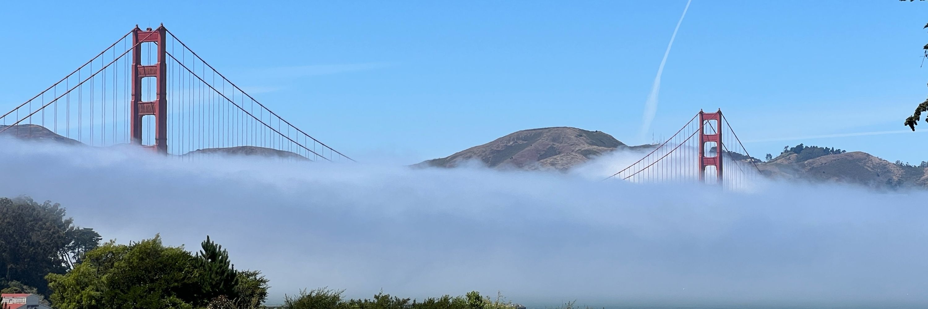
Bay Area moment


November 18, 2025 at 6:29 PM
Bay Area moment
John Oliver discusses the vital role public media plays in the lives of many Americans, how the Trump Administration’s massive budget cuts could impact those Americans directly

Public Media: Last Week Tonight with John Oliver (HBO)
YouTube video by LastWeekTonight
youtu.be
November 18, 2025 at 2:58 AM
John Oliver discusses the vital role public media plays in the lives of many Americans, how the Trump Administration’s massive budget cuts could impact those Americans directly