


"The absence of Canadian geodetic observatories has direct consequences for its own space program. #radarsat, once a symbol of Canadian leadership in space, is today the only major commercial synthetic aperture radar mission not supported by the International Laser Ranging Service." - Anusuya Datta
October 22, 2025 at 1:48 PM
Everybody can reply

I had a giggle at some of those suggestions.
➡️ It is a (trihedral) CORNER REFLECTOR, made of three plates forming a corner. It is used for calibrating SAR satellite systems (in our case, RADARSAT). Its design provides a strong, predictable reflection that is not sensitive to its orientation.
🛰️📡🧪
➡️ It is a (trihedral) CORNER REFLECTOR, made of three plates forming a corner. It is used for calibrating SAR satellite systems (in our case, RADARSAT). Its design provides a strong, predictable reflection that is not sensitive to its orientation.
🛰️📡🧪
If you’re at the Ottawa Central Experimental Farm, you may see this.
What is it? Wrong answers only.
Agriculture.canada.ca
🧪🛰️ 📡
What is it? Wrong answers only.
Agriculture.canada.ca
🧪🛰️ 📡

October 10, 2025 at 11:04 PM
Everybody can reply
2 reposts
8 likes
Canada’s satellites monitor Earth’s climate, land, and ecosystems while supporting space research. Technologies like RADARSAT and SCISAT allow us to protect habitats, study geodiversity, and prepare for challenges in a changing world. 2/3
Photo credits: Ryan Hagerty
Photo credits: Ryan Hagerty

October 6, 2025 at 3:44 PM
Everybody can reply

A great opportunity for conducting important research in the tropical forests! 🌳
#geospatial #remotesensing #sar #radarsat
#geospatial #remotesensing #sar #radarsat

RADARSAT-2 Tropical Forests: data access opportunity
A data access opportunity aims to make a unique, long-term archive of RADARSAT-2 data freely available to scientists and organizations around the world.
www.asc-csa.gc.ca
September 22, 2025 at 1:47 AM
Everybody can reply
2 reposts
4 likes
ℹ️🛰️ Canadian Agricultural Science from Space 🍁🧪
How does Canada's #RADARSAT Constellation of Synthetic Aperture Radar (SAR) satellites support Canadian agricultural monitoring?
Check out the video we did in 2019 that explains it all ⤵️
- via agriculture.Canada.ca
🔗 youtu.be/0I0p9GAv3hk?...
How does Canada's #RADARSAT Constellation of Synthetic Aperture Radar (SAR) satellites support Canadian agricultural monitoring?
Check out the video we did in 2019 that explains it all ⤵️
- via agriculture.Canada.ca
🔗 youtu.be/0I0p9GAv3hk?...

RADARSAT Constellation Mission: Agricultural Science from Space
YouTube video by Agriculture and Agri-Food Canada
youtu.be
August 21, 2025 at 11:09 AM
Everybody can reply
2 reposts
4 likes
Bare minimum of holding a conversation: SAR, compact-pol, #RADARSAT, speckle filtering, Freeman-Durden and Yamaguchi.
going to go out on a limb and imagine this guy's not actually very good at conversations

August 18, 2025 at 4:06 PM
Everybody can reply

I don’t remember that one. I did write some software to talk to the SPOT and RADARSAT satellites in the 90s though, probably not related 🤓
August 6, 2025 at 4:58 PM
Everybody can reply
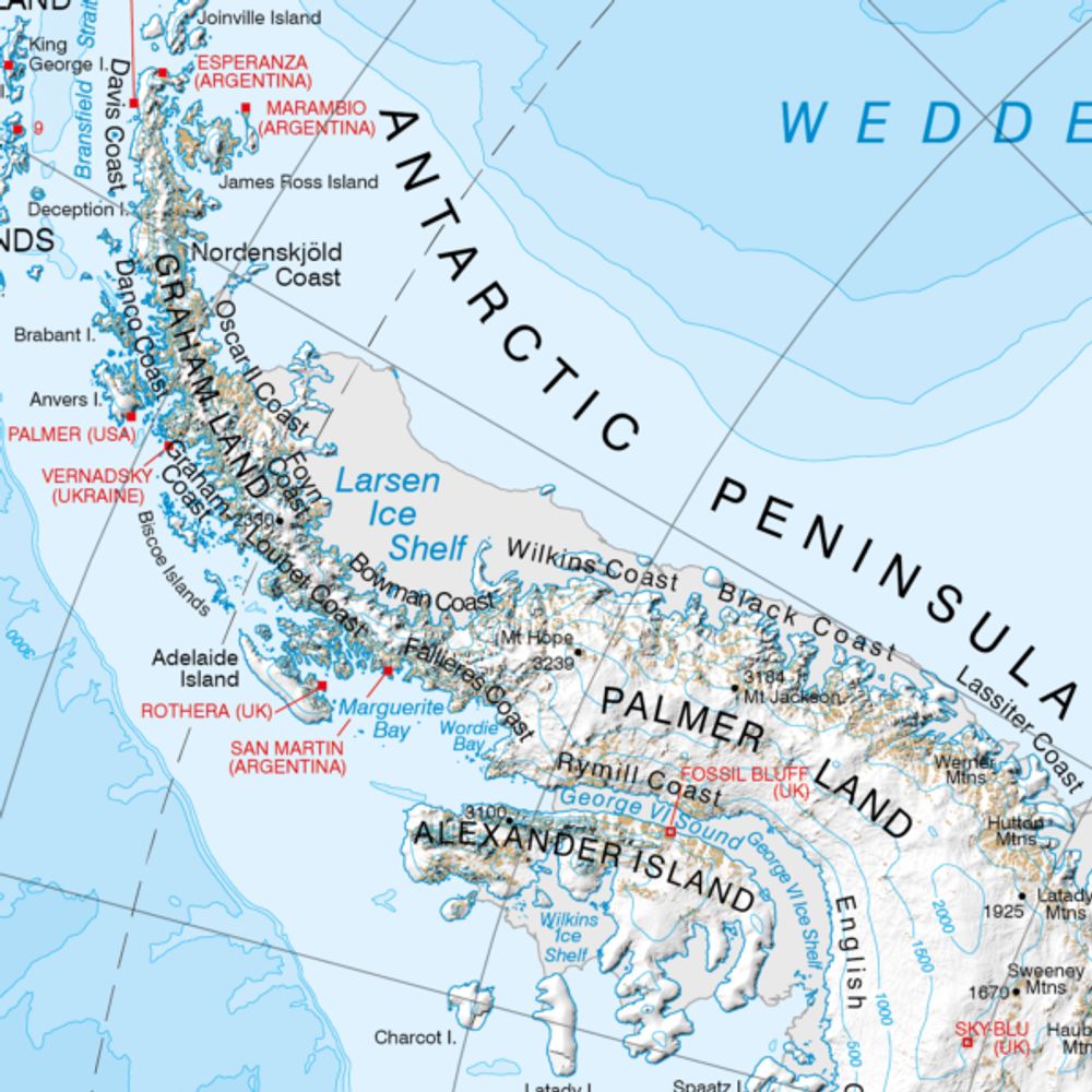
NASA Astronomy Hourly Picture - 1999-11-16: A RADARSAT Map of Antarctica
#Astronomy #NASA #Space
#Astronomy #NASA #Space

August 5, 2025 at 11:20 PM
Everybody can reply
1 likes

This
⬇️🍁⬇️🍁⬇️🍁⬇️🍁
Chris Hadfield
@Cmdr_Hadfield
Happy Canada Day!
My beloved country, the true north strong and free.
(image by Radarsat via
@csa_asc
) asc-csa.gc.ca/eng/multimed...
⬇️🍁⬇️🍁⬇️🍁⬇️🍁
Chris Hadfield
@Cmdr_Hadfield
Happy Canada Day!
My beloved country, the true north strong and free.
(image by Radarsat via
@csa_asc
) asc-csa.gc.ca/eng/multimed...

Canada in 3222 RADARSAT Constellation Mission images – 17 x 11 inch poster
The RADARSAT Constellation Mission (RCM) consists of three Earth observation satellites. It helps with maritime surveillance, disaster management and ecosystem monitoring in Canada and around the worl...
asc-csa.gc.ca
July 2, 2025 at 7:31 AM
Everybody can reply
1 reposts
1 likes

[The Times of India]Scientists discover 34 million year old hidden river world buried under 2 km of Antarctic ice - Times of India Trending News: Beneath East Antarctica's thick ice, scientists have uncovered a hidden, ancient landscape untouched for 34 million years. Using RADARSAT technology,


June 10, 2025 at 8:45 AM
Everybody can reply

proposed framework is further demonstrated using measured RADARSAT-2 data, corroborating the results obtained from the simulations. [8/8 of https://arxiv.org/abs/2505.11137v1]
May 19, 2025 at 6:02 AM
Everybody can reply


Fortunately, we have the technology, especially in radar imaging satellites, and a commercial sector, including the Canadian company MDA Space, that can deliver. MDA built the RADARSAT Constellation Mission satellites, among the most advanced in the world.
April 15, 2025 at 6:04 AM
Everybody can reply
🎉 Imagery from the newly launched Sentinel-1C Copernicus satellite is now accessible via Polar View www.polarview.aq and the Ice Logistics Portal www.icelogistics.info/antarctic?ce...! This addition significantly increases the repeatability of SAR observations in the Polar Regions 🛰️
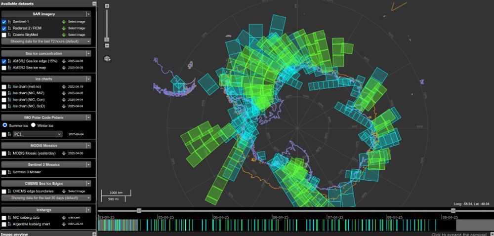
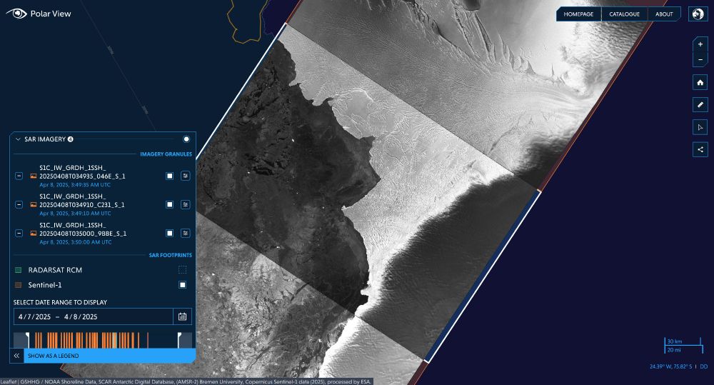
April 8, 2025 at 4:48 PM
Everybody can reply
9 reposts
2 quotes
27 likes

...Or more complex if use thickness of actual ice, excluding open water.
Thickness is hard to measure (therefore so is volume). It is now measured by radarsat probing, but that's tricky because of snow cover, aot.
Real-time thickness and volume series, including this one, are from tracking models.
Thickness is hard to measure (therefore so is volume). It is now measured by radarsat probing, but that's tricky because of snow cover, aot.
Real-time thickness and volume series, including this one, are from tracking models.
March 22, 2025 at 11:29 PM
Everybody can reply
1 reposts
2 likes

We got to develop kick ass air defence. We have excellent radar technology: Radarsat II and the CHIME telescope for examples. We make commercial quantum computers. We can collaborate with Europe on the missile part. We have the talents. We have what it takes for innovative solutions.
March 20, 2025 at 2:03 AM
Everybody can reply
2 likes

Would that the prize be access to the Radarsat-2 archive :)
March 12, 2025 at 11:34 AM
Everybody can reply

Why not? We've been a Cooperating State within the European Space Agency since 1979.
I remember there being ESA posters scattered around the office at RADARSAT when I did three co-op work terms there in the late 80s. (I may even have a few still stashed away.)
I remember there being ESA posters scattered around the office at RADARSAT when I did three co-op work terms there in the late 80s. (I may even have a few still stashed away.)
March 12, 2025 at 8:19 AM
Everybody can reply
🛰 So, I asked AI to design me a Lego #RADARSAT satellite (C-band Synthetic Aperture Radar).
➡️ Ten points to Gryffindor for anyone who can tell me what is missing! 🧪
➡️ Ten points to Gryffindor for anyone who can tell me what is missing! 🧪

March 12, 2025 at 12:56 AM
Everybody can reply
2 reposts
11 likes
GPS-III-01 - USAF, 2018
S-5 - Air Force Research, 2019 (rideshare)
Crew Dragon DM-1 - NASA, 2019
CRS-17 - NASA, 2019
RADARSAT - Canadian Space Agency, 2019
STP-2 - USAF, 2019
CRS-18 - NASA, 2019
CRS-19 - NASA, 2019
Crew Dragon IFAT - NASA, 2020
CRS-20 - NASA, 2020
DM-2 - NASA, 2020
S-5 - Air Force Research, 2019 (rideshare)
Crew Dragon DM-1 - NASA, 2019
CRS-17 - NASA, 2019
RADARSAT - Canadian Space Agency, 2019
STP-2 - USAF, 2019
CRS-18 - NASA, 2019
CRS-19 - NASA, 2019
Crew Dragon IFAT - NASA, 2020
CRS-20 - NASA, 2020
DM-2 - NASA, 2020
March 7, 2025 at 10:24 PM
Everybody can reply
🍁 This is why it is critical that Canada continues to have its own Earth Observation programs and expertise, particularly in Synthetic Aperture Radar (SAR). #RADARSAT #RADARSAT+ #CanadianSpaceAgency #AgenceSpatialeCanadienne
www.washingtonpost.com/national-sec...
www.washingtonpost.com/national-sec...

U.S. suspends commercial satellite imagery service to Ukraine
Maxar, a leading provider of orbital imagery, said that the U.S. government has decided to temporarily suspend services to Ukraine. Soldiers on the ground are feeling the impact already.
www.washingtonpost.com
March 7, 2025 at 8:44 PM
Everybody can reply
3 likes
I'm way out of my depth here, so take these as the ignorant ravings that they are, but off the top of my head:
* A CSA with dozens of radarsat-like programs
* A CanmetMATERIALS unit focused on construction in permafrost
* A Grain Research Laboratory empowered by a mandate beyond quality and safety.
* A CSA with dozens of radarsat-like programs
* A CanmetMATERIALS unit focused on construction in permafrost
* A Grain Research Laboratory empowered by a mandate beyond quality and safety.
March 4, 2025 at 11:03 AM
Everybody can reply

#Copernicus Emergency Management Service was recently activated due to flooding in France and I love how they used so many different radar satellites to assess flood extent. From Sentinel-1 to RADARSAT-2, ICEYE, COSMO-SkyMed, PAZ, TerraSAR 🛰️
rapidmapping.emergency.copernicus.eu/EMSR788/repo...
rapidmapping.emergency.copernicus.eu/EMSR788/repo...
Copernicus EMS Rapid Mapping Activation Viewer
Rapid Mapping Activation Viewer
rapidmapping.emergency.copernicus.eu
February 14, 2025 at 10:48 AM
Everybody can reply
[2/3] Les lacs sous la glace détectés par ICESat et ICESat-2 montrent un drainage vers la ligne de contact entre glace et fond marin, impactant la fonte basale et la circulation sous les plateformes de glace. Ces découvertes aident à comprendre les changements climatiques en #Antarctique. #geography

January 30, 2025 at 5:53 AM
Everybody can reply