


Tyler Morgan-Wall
@tylermw.com
R, data science, dataviz, maps, experimental design, raytracing. Developer of rayshader, rayrender, and the rayverse | PhD in Physics from Johns Hopkins | Penn
Pinned
Tyler Morgan-Wall
@tylermw.com
· Nov 8
Hi all! A (re)-introduction: I'm Tyler, developer of #rayshader and the #rayverse, a collection of R packages for 3D #dataviz and #mapping.
Here's one of my greatest hits (now that Bluesky supports videos!): The Earth's submarine fiber optic cable network, visualized in #RStats with #rayrender.
Here's one of my greatest hits (now that Bluesky supports videos!): The Earth's submarine fiber optic cable network, visualized in #RStats with #rayrender.
Reposted by Tyler Morgan-Wall

#30DayMapChallenge #30DayMapChallenge2025 #30DayMapChallengeRbanism #30DayMapChallengeR
Day 18: Out Of This World
Render a 3D map of Olympus Mons on Mars using elevation data
by Ignacio Urria Yáñez.
#GeoData #rstats #DataViz #Maps #SpatialViz
Day 18: Out Of This World
Render a 3D map of Olympus Mons on Mars using elevation data
by Ignacio Urria Yáñez.
#GeoData #rstats #DataViz #Maps #SpatialViz


November 18, 2025 at 12:26 PM
#30DayMapChallenge #30DayMapChallenge2025 #30DayMapChallengeRbanism #30DayMapChallengeR
Day 18: Out Of This World
Render a 3D map of Olympus Mons on Mars using elevation data
by Ignacio Urria Yáñez.
#GeoData #rstats #DataViz #Maps #SpatialViz
Day 18: Out Of This World
Render a 3D map of Olympus Mons on Mars using elevation data
by Ignacio Urria Yáñez.
#GeoData #rstats #DataViz #Maps #SpatialViz
Reposted by Tyler Morgan-Wall

#30DayMapsChallenge
Day 17: A new tool
Played around with #rayshader to look at Mont Rainier (Washington).
Day 17: A new tool
Played around with #rayshader to look at Mont Rainier (Washington).

November 17, 2025 at 4:33 PM
#30DayMapsChallenge
Day 17: A new tool
Played around with #rayshader to look at Mont Rainier (Washington).
Day 17: A new tool
Played around with #rayshader to look at Mont Rainier (Washington).
One thing I appreciate about {targets} is the robustness of the pipeline: if I need to stop a long, compute-intensive process to run something else (or, in this case, I resize a pane and make the IDE crash🤷♂️), I don't need to worry about corrupted state: just restart R and tar_make() away!
#RStats
#RStats

November 17, 2025 at 2:11 PM
One thing I appreciate about {targets} is the robustness of the pipeline: if I need to stop a long, compute-intensive process to run something else (or, in this case, I resize a pane and make the IDE crash🤷♂️), I don't need to worry about corrupted state: just restart R and tar_make() away!
#RStats
#RStats
‼️ #rayverse package update: #rayvertex v0.14.0 released! This overhauls the toon shading algorithm to use a screen space jump fill algorithm (JFA), removing the brittle inverse mesh hack that existed up until now.
#RStats
#RStats
November 17, 2025 at 1:50 PM
‼️ #rayverse package update: #rayvertex v0.14.0 released! This overhauls the toon shading algorithm to use a screen space jump fill algorithm (JFA), removing the brittle inverse mesh hack that existed up until now.
#RStats
#RStats
Reposted by Tyler Morgan-Wall

November 14, 2025 at 6:57 PM

November 14, 2025 at 3:05 PM
Reposted by Tyler Morgan-Wall

a “Space Force”, if you will


November 13, 2025 at 2:27 PM
a “Space Force”, if you will
Oh thank god I finally fixed this rayshader 3D ggplot issue that has been bothering me for YEARS (thankfully before anyone called me out on it)
#RStats #rayshader
#RStats #rayshader
November 12, 2025 at 5:23 AM
Oh thank god I finally fixed this rayshader 3D ggplot issue that has been bothering me for YEARS (thankfully before anyone called me out on it)
#RStats #rayshader
#RStats #rayshader
Reposted by Tyler Morgan-Wall

Aurora down in northern Illinois. Only the third time I've seen it

November 12, 2025 at 3:25 AM
Aurora down in northern Illinois. Only the third time I've seen it
Reposted by Tyler Morgan-Wall

Sur un #R du #30DayMapChallenge #line, j'ai découvert le pkg #rayshader (3D).
J'ai donc pensé à représenter mon île, la Réunion, selon l'altitude 😊 avec le 3 cirques et le Piton des Neiges qui culmine à 3070m. #rstats
Données trouvées courbes de niveaux: geoservices.ign.fr/courbes-de-n...
J'ai donc pensé à représenter mon île, la Réunion, selon l'altitude 😊 avec le 3 cirques et le Piton des Neiges qui culmine à 3070m. #rstats
Données trouvées courbes de niveaux: geoservices.ign.fr/courbes-de-n...


November 9, 2025 at 6:50 PM
Sur un #R du #30DayMapChallenge #line, j'ai découvert le pkg #rayshader (3D).
J'ai donc pensé à représenter mon île, la Réunion, selon l'altitude 😊 avec le 3 cirques et le Piton des Neiges qui culmine à 3070m. #rstats
Données trouvées courbes de niveaux: geoservices.ign.fr/courbes-de-n...
J'ai donc pensé à représenter mon île, la Réunion, selon l'altitude 😊 avec le 3 cirques et le Piton des Neiges qui culmine à 3070m. #rstats
Données trouvées courbes de niveaux: geoservices.ign.fr/courbes-de-n...
Reposted by Tyler Morgan-Wall

#30DayMapChallenge – Day 5: Earth
Given the importance of these, global occurrence of rare earth elements according to U.S. Geological Survey (USGS) and the great hashtag#rayrender package in R.
Given the importance of these, global occurrence of rare earth elements according to U.S. Geological Survey (USGS) and the great hashtag#rayrender package in R.
November 5, 2025 at 2:55 PM
#30DayMapChallenge – Day 5: Earth
Given the importance of these, global occurrence of rare earth elements according to U.S. Geological Survey (USGS) and the great hashtag#rayrender package in R.
Given the importance of these, global occurrence of rare earth elements according to U.S. Geological Survey (USGS) and the great hashtag#rayrender package in R.
Reposted by Tyler Morgan-Wall

I think that @davisvaughan.bsky.social figured this out.
add the following to your settings.json should do the trick
"window.title": "${activeEditorShort}${separator}${rootName}${separator}${profileName}${separator}${activeRepositoryBranchName}"
add the following to your settings.json should do the trick
"window.title": "${activeEditorShort}${separator}${rootName}${separator}${profileName}${separator}${activeRepositoryBranchName}"
November 7, 2025 at 4:30 AM
I think that @davisvaughan.bsky.social figured this out.
add the following to your settings.json should do the trick
"window.title": "${activeEditorShort}${separator}${rootName}${separator}${profileName}${separator}${activeRepositoryBranchName}"
add the following to your settings.json should do the trick
"window.title": "${activeEditorShort}${separator}${rootName}${separator}${profileName}${separator}${activeRepositoryBranchName}"
Reposted by Tyler Morgan-Wall

November 8, 2025 at 2:05 PM
Reposted by Tyler Morgan-Wall

November 8, 2025 at 1:52 PM
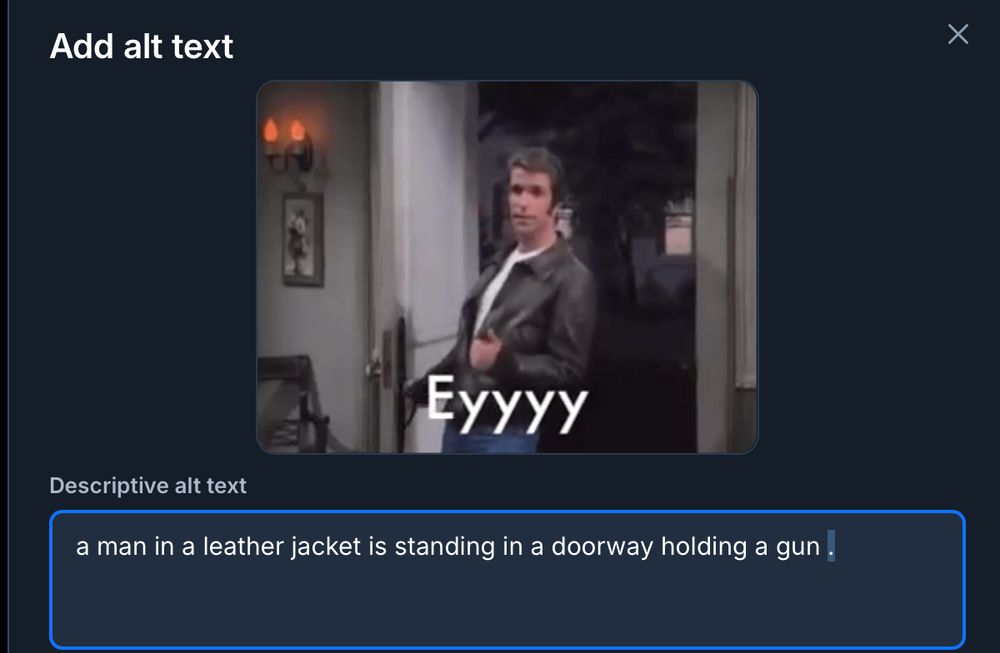
uhh always check your gif's AI-generated alt text before posting
November 8, 2025 at 1:37 AM
uhh always check your gif's AI-generated alt text before posting
Day 6 of the #30DayMapChallenge (3D), a render of Mount Rainier with a realistic atmospheric skydome generated w/ a lat/long/datetime, rendered entirely in #RStats with #rayshader and #rayrender! The atmosphere is annoyingly realistic: I now have to dial in the exposure depending on the time of day!


November 8, 2025 at 1:14 AM
Day 6 of the #30DayMapChallenge (3D), a render of Mount Rainier with a realistic atmospheric skydome generated w/ a lat/long/datetime, rendered entirely in #RStats with #rayshader and #rayrender! The atmosphere is annoyingly realistic: I now have to dial in the exposure depending on the time of day!
Reposted by Tyler Morgan-Wall
Tree canopy height of Paris, France. Have given up on #30DayMapChallenge.
#rayshader adventures, an #rstats tale
#rayshader adventures, an #rstats tale

November 7, 2025 at 4:09 PM
Tree canopy height of Paris, France. Have given up on #30DayMapChallenge.
#rayshader adventures, an #rstats tale
#rayshader adventures, an #rstats tale
Reposted by Tyler Morgan-Wall

3D Tanaka contour map of Scotland with #rayshader for Day 6 of the #30DayMapChallenge - Dimensions.
Code: github.com/rajodm/30Day...
Thanks @milos-makes-maps.bsky.social for the helpful tutorial!
#dataviz #rstats #ggplot2
Code: github.com/rajodm/30Day...
Thanks @milos-makes-maps.bsky.social for the helpful tutorial!
#dataviz #rstats #ggplot2

November 7, 2025 at 10:40 AM
3D Tanaka contour map of Scotland with #rayshader for Day 6 of the #30DayMapChallenge - Dimensions.
Code: github.com/rajodm/30Day...
Thanks @milos-makes-maps.bsky.social for the helpful tutorial!
#dataviz #rstats #ggplot2
Code: github.com/rajodm/30Day...
Thanks @milos-makes-maps.bsky.social for the helpful tutorial!
#dataviz #rstats #ggplot2
Reposted by Tyler Morgan-Wall

Day 6 of the #30DayMapChallenge makes things 3D! I took my elevation map from yesterday and made it so with the {rayshader} package.
#DataViz #RStats #ggplot2
#DataViz #RStats #ggplot2

November 7, 2025 at 1:08 AM
Day 6 of the #30DayMapChallenge makes things 3D! I took my elevation map from yesterday and made it so with the {rayshader} package.
#DataViz #RStats #ggplot2
#DataViz #RStats #ggplot2
Reposted by Tyler Morgan-Wall

Had a bit of fun making a new map of the False Creek area
Still a work in progress, but I like the direction
#rstudio #rayshader #vancouver
Still a work in progress, but I like the direction
#rstudio #rayshader #vancouver

November 7, 2025 at 12:59 AM
Had a bit of fun making a new map of the False Creek area
Still a work in progress, but I like the direction
#rstudio #rayshader #vancouver
Still a work in progress, but I like the direction
#rstudio #rayshader #vancouver
Reposted by Tyler Morgan-Wall

A little bit of #ggplot2 and #rayshader for the "dimensions" prompt on day 6 of the #30DayMapChallenge! 🌧️
#RStats #DataViz
#RStats #DataViz

November 6, 2025 at 11:43 PM
A little bit of #ggplot2 and #rayshader for the "dimensions" prompt on day 6 of the #30DayMapChallenge! 🌧️
#RStats #DataViz
#RStats #DataViz
Reposted by Tyler Morgan-Wall

Day 6 — Dimensions
3D Geological Map of Asturias
A blend of past and present — combining mid-20th century geology with modern topography to reimagine the landscapes of Asturias in 3D.
#30DayMapChallenge #Dimensions #Asturias #Cartography #rayshader
3D Geological Map of Asturias
A blend of past and present — combining mid-20th century geology with modern topography to reimagine the landscapes of Asturias in 3D.
#30DayMapChallenge #Dimensions #Asturias #Cartography #rayshader

November 6, 2025 at 3:55 PM
Day 6 — Dimensions
3D Geological Map of Asturias
A blend of past and present — combining mid-20th century geology with modern topography to reimagine the landscapes of Asturias in 3D.
#30DayMapChallenge #Dimensions #Asturias #Cartography #rayshader
3D Geological Map of Asturias
A blend of past and present — combining mid-20th century geology with modern topography to reimagine the landscapes of Asturias in 3D.
#30DayMapChallenge #Dimensions #Asturias #Cartography #rayshader
I like Positron a lot for package development*! But after a year-ish of using it, I find myself consistently sticking with RStudio for data analysis work. RStudio just has a much higher SNR and it's fixed layout is much less prone to clutter, which is nice for cognitive-heavy loads.
#RStats
#RStats
November 6, 2025 at 8:41 PM
I like Positron a lot for package development*! But after a year-ish of using it, I find myself consistently sticking with RStudio for data analysis work. RStudio just has a much higher SNR and it's fixed layout is much less prone to clutter, which is nice for cognitive-heavy loads.
#RStats
#RStats
Reposted by Tyler Morgan-Wall

okay writing a mesh beveling algorithm is like the fencepost issue on steroids

November 6, 2025 at 4:44 PM
okay writing a mesh beveling algorithm is like the fencepost issue on steroids
Reposted by Tyler Morgan-Wall

Day 6 of #30DayMapChallenge ~ Dimensions.
Half-marathon challenge route.
#rstats #dataviz #rayshader #gis #map #spatial
Half-marathon challenge route.
#rstats #dataviz #rayshader #gis #map #spatial

November 6, 2025 at 11:27 AM
Day 6 of #30DayMapChallenge ~ Dimensions.
Half-marathon challenge route.
#rstats #dataviz #rayshader #gis #map #spatial
Half-marathon challenge route.
#rstats #dataviz #rayshader #gis #map #spatial