


Shankho Niyogi
@seismologic.bsky.social
Seismologist PhD student from UC Riverside. Interested in seismic studies of earthquakes, ambient noise and anthropogenic events. Currently looking for postdoc opportunities.
Pinned
Reposted by Shankho Niyogi

For two decades, GPS station P056 in Porterville, California has been steadily tracking the ground moving down. Since its installation, the ground has subsided over 3.5 feet. Located in central California’s San Joaquin Valley, P056 records subsidence driven by long-term groundwater overpumping.
November 24, 2025 at 6:30 PM
For two decades, GPS station P056 in Porterville, California has been steadily tracking the ground moving down. Since its installation, the ground has subsided over 3.5 feet. Located in central California’s San Joaquin Valley, P056 records subsidence driven by long-term groundwater overpumping.
Well put !

![Comic. Someone is claiming to predict the exact date of a future earthquake. Should you listen? [flowchart: start] → NO (There are big earthquakes constantly, so if anyone ever *does* figure this out, it will be immediately obvious that their method works and then the world’s seismologists will not shut up about it. You won’t need this flowchart.)](https://cdn.bsky.app/img/feed_thumbnail/plain/did:plc:cz73r7iyiqn26upot4jtjdhk/bafkreic7wdqg4w6qfevbqzzq4esd6237pojsnpwsrbb7gaxsxobqaiwazm@jpeg)
November 11, 2025 at 12:39 AM
Well put !
Just wanted to showcase that you plot the mean amplitude (60 sec window) over the week and half when Melissa was at the strongest you can see the event very clearly. The spectrogram show the frequency bands where the energy of the hurricane is the strongest.

November 9, 2025 at 10:56 PM
Just wanted to showcase that you plot the mean amplitude (60 sec window) over the week and half when Melissa was at the strongest you can see the event very clearly. The spectrogram show the frequency bands where the energy of the hurricane is the strongest.
Reposted by Shankho Niyogi

4 days of seismic records from a seismic station in Jamaica shows Hurricane Melissa roaring towards the island.
Hurricanes increase the amplitude of ocean waves which beat on the coast and sea floor. These produce Rayleigh waves that can be seen as increasingly thick “wiggles” in seismic records 🧪
Hurricanes increase the amplitude of ocean waves which beat on the coast and sea floor. These produce Rayleigh waves that can be seen as increasingly thick “wiggles” in seismic records 🧪


October 28, 2025 at 1:24 PM
4 days of seismic records from a seismic station in Jamaica shows Hurricane Melissa roaring towards the island.
Hurricanes increase the amplitude of ocean waves which beat on the coast and sea floor. These produce Rayleigh waves that can be seen as increasingly thick “wiggles” in seismic records 🧪
Hurricanes increase the amplitude of ocean waves which beat on the coast and sea floor. These produce Rayleigh waves that can be seen as increasingly thick “wiggles” in seismic records 🧪
Discovering Digital Infrared Photography (Webinar Replay)
YouTube video by Jason P. Odell Photography
youtu.be
September 15, 2025 at 4:21 AM
Video Shows Pulsing and Curving Fault Behavior - Eos share.google/uuv6diA68EpY...
Video Shows Pulsing and Curving Fault Behavior - Eos
A chance video captured a fault rupture during March’s devastating Myanmar earthquake, delivering real-time evidence of how major seismic tremors propagate.
share.google
August 25, 2025 at 9:56 PM
Video Shows Pulsing and Curving Fault Behavior - Eos share.google/uuv6diA68EpY...
Reposted by Shankho Niyogi

Hey everybody! @drjuliawester.bsky.social and I have a new paper!
We surveyed over 800 scientists, science communicators, and science educators who use social media.
Conclusion: Scientists no longer find Twitter useful or pleasant, and many have switched to Bluesky! 🧪🌎🦑
doi.org/10.1093/icb/...
We surveyed over 800 scientists, science communicators, and science educators who use social media.
Conclusion: Scientists no longer find Twitter useful or pleasant, and many have switched to Bluesky! 🧪🌎🦑
doi.org/10.1093/icb/...
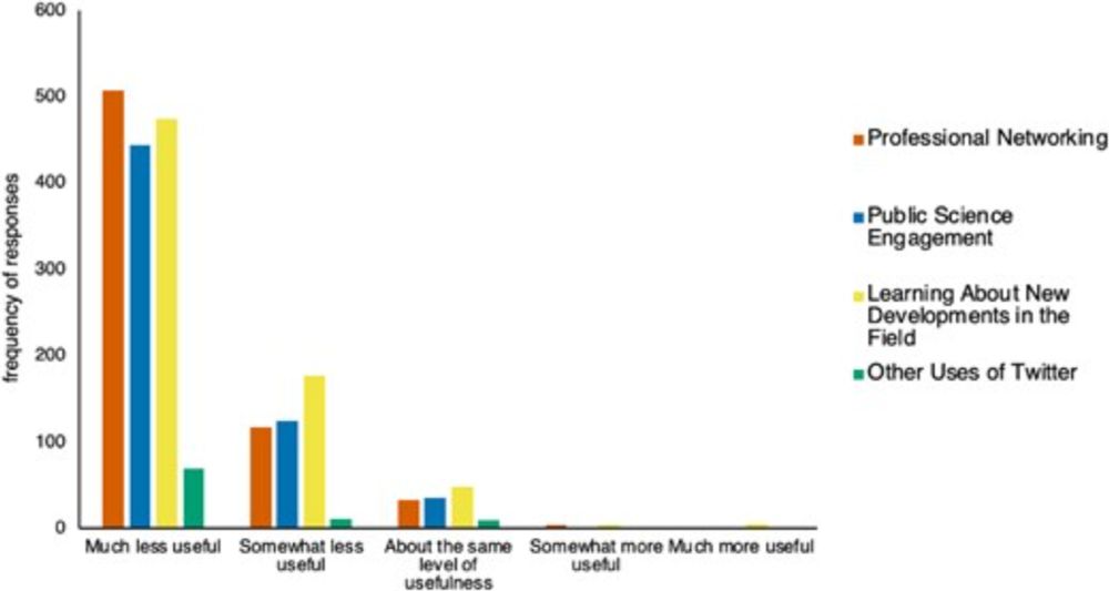
Scientists no Longer Find Twitter Professionally Useful, and have Switched to Bluesky
Synopsis. Social media has become widely used by the scientific community for a variety of professional uses, including networking and public outreach. For
doi.org
August 19, 2025 at 2:34 PM
Hey everybody! @drjuliawester.bsky.social and I have a new paper!
We surveyed over 800 scientists, science communicators, and science educators who use social media.
Conclusion: Scientists no longer find Twitter useful or pleasant, and many have switched to Bluesky! 🧪🌎🦑
doi.org/10.1093/icb/...
We surveyed over 800 scientists, science communicators, and science educators who use social media.
Conclusion: Scientists no longer find Twitter useful or pleasant, and many have switched to Bluesky! 🧪🌎🦑
doi.org/10.1093/icb/...
Reposted by Shankho Niyogi

It's Day 1 proper of this year's EarthScope #InSAR Processing and Analysis short course (the "ISCE+" course)! Here, Franz Meyer is leading participants through a simple Mogi source modeling exercise using InSAR data from Okmok volcano! Real data and real models on an interactive online platform!

August 18, 2025 at 7:04 PM
It's Day 1 proper of this year's EarthScope #InSAR Processing and Analysis short course (the "ISCE+" course)! Here, Franz Meyer is leading participants through a simple Mogi source modeling exercise using InSAR data from Okmok volcano! Real data and real models on an interactive online platform!
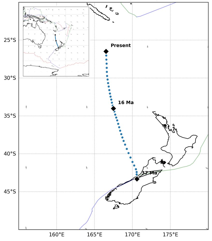
A big shout-out to the team behind GPlates and PyGPlates. Visualization of plate motions and points is very convenient now.
github.com/GPlates/GPla...
github.com/GPlates/GPla...
August 18, 2025 at 4:33 AM
A big shout-out to the team behind GPlates and PyGPlates. Visualization of plate motions and points is very convenient now.
github.com/GPlates/GPla...
github.com/GPlates/GPla...
Reposted by Shankho Niyogi

Copied from AEC post on X: Check out these amazing photos of the Tracy Arm Landslide! Thank you to Jacek Macelko for sharing these images, taken on Tuesday, August 12 from 3,500 ft. The pale triangle of the landslide scar stands out. 🧪⚒️🪨 1/2


August 14, 2025 at 6:34 PM
Copied from AEC post on X: Check out these amazing photos of the Tracy Arm Landslide! Thank you to Jacek Macelko for sharing these images, taken on Tuesday, August 12 from 3,500 ft. The pale triangle of the landslide scar stands out. 🧪⚒️🪨 1/2
Reposted by Shankho Niyogi
It has been a busy couple of days! There was a large landslide and tsunami in SE Alaska, in Tracy Arm, Sunday morning. Luckily, no injuries or casualties were reported. This region is outside of our current landslide coverage, but we were able to get a quick location after hearing about the event. 🧵
August 13, 2025 at 2:29 AM
It has been a busy couple of days! There was a large landslide and tsunami in SE Alaska, in Tracy Arm, Sunday morning. Luckily, no injuries or casualties were reported. This region is outside of our current landslide coverage, but we were able to get a quick location after hearing about the event. 🧵
Reposted by Shankho Niyogi
The M6.1 shallow #earthquake near Bigadic, Turkey, occurred on a normal fault system, possibly the Sindirgi-Sincanli Fault Zone. A similar event occurred near Simav in 2011 and generated significant damage around the epicenter. ⚒️🧪

August 10, 2025 at 6:15 PM
The M6.1 shallow #earthquake near Bigadic, Turkey, occurred on a normal fault system, possibly the Sindirgi-Sincanli Fault Zone. A similar event occurred near Simav in 2011 and generated significant damage around the epicenter. ⚒️🧪
Indian Satellite data based analysis of the Dharali Flash Flood
www.isro.gov.in
August 7, 2025 at 8:55 PM
Reposted by Shankho Niyogi
Tsunami video allegedly taken at Pionerskaya bay after the M8.8 Kamchatka #earthquake. HOLY SHIT! This guy and his dog are unbelievably lucky. 🧪⚒️ #geology
youtube.com/shorts/LhFQ2...
youtube.com/shorts/LhFQ2...
MASSIVE Tsunami Hits Pionerskaya Bay, Kamchatka, Russia (HQ)
YouTube video by 2025 Kamchatka Earthquake & Tsunami Archive
youtube.com
August 4, 2025 at 9:17 PM
Tsunami video allegedly taken at Pionerskaya bay after the M8.8 Kamchatka #earthquake. HOLY SHIT! This guy and his dog are unbelievably lucky. 🧪⚒️ #geology
youtube.com/shorts/LhFQ2...
youtube.com/shorts/LhFQ2...
Reposted by Shankho Niyogi

Looks like a small swarm in the Fontana trend. This M4.2 had a few foreshcoks including a M3.0. The Fontana trend is a NE-striking lineation of earthquakes under the sediments of the San Bernardino Vslley. We believe it is one of the left-lateral striking faults that are south of the San Gabriels.

#AutoEQ A magnitude 4.2 (MI) #earthquake has occurred 4 mi W of Muscoy, CA at 09:32 PDT Jul 31, 2025 [2025-07-31 16:32 UTC]. #SCSN has not yet confirmed this event. For more info visit http://earthquake.usgs.gov/earthquakes/eventpage/ci41249496#executive
July 31, 2025 at 4:41 PM
Looks like a small swarm in the Fontana trend. This M4.2 had a few foreshcoks including a M3.0. The Fontana trend is a NE-striking lineation of earthquakes under the sediments of the San Bernardino Vslley. We believe it is one of the left-lateral striking faults that are south of the San Gabriels.
Reposted by Shankho Niyogi
Watch the seismic waves from the magnitude 8.8 earthquake off the coast of Russia sweep beneath seismic stations in North America.
By the time the waves reached North America, they are far too small to be felt by people, but can still be detected by seismic instruments. 🧪
By the time the waves reached North America, they are far too small to be felt by people, but can still be detected by seismic instruments. 🧪
July 30, 2025 at 5:19 AM
Watch the seismic waves from the magnitude 8.8 earthquake off the coast of Russia sweep beneath seismic stations in North America.
By the time the waves reached North America, they are far too small to be felt by people, but can still be detected by seismic instruments. 🧪
By the time the waves reached North America, they are far too small to be felt by people, but can still be detected by seismic instruments. 🧪
Reposted by Shankho Niyogi

A rule of thumb for tsunamis is that in open ocean, they move at similar speeds to commercial airliners. If you're ever curious how long it would take for a tsunami to get from one place to another, look up the duration of a similar-length flight.
July 30, 2025 at 1:38 AM
A rule of thumb for tsunamis is that in open ocean, they move at similar speeds to commercial airliners. If you're ever curious how long it would take for a tsunami to get from one place to another, look up the duration of a similar-length flight.
Reposted by Shankho Niyogi
In 1952 there was a M 9.0 in the vicinity of today’s M 8.8 - here’s USGS info about that prior event off Kamchatka - earthquake.usgs.gov/earthquakes/...
The Earthquake Event Page application supports most recent browsers, view supported browsers. Or, try our Real-time Notifications, Feeds, and Web Services.
earthquake.usgs.gov
July 30, 2025 at 3:02 AM
In 1952 there was a M 9.0 in the vicinity of today’s M 8.8 - here’s USGS info about that prior event off Kamchatka - earthquake.usgs.gov/earthquakes/...
Reposted by Shankho Niyogi

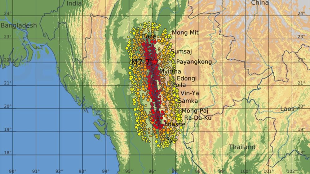
🔥OPEN ACCESS+PRESS RELEASE🔥The 28 March 2025 Mw 7.8 Myanmar Earthquake: Preliminary Analysis of an ∼480 km Long Intermittent Supershear Rupture#TSR ⚒️
A study of the recent Myanmar earthquake suggests supershear for some sections, reaching speeds of 5 to 6 km/s.
www.seismosoc.org/news/first-a...
A study of the recent Myanmar earthquake suggests supershear for some sections, reaching speeds of 5 to 6 km/s.
www.seismosoc.org/news/first-a...

First Analyses of Myanmar Earthquake Conclude Fault Ruptured at Supershear Velocity | Seismological Society of America
11 July 2025—The first studies of the 28 March 2025 magnitude 7.8 Myanmar earthquake suggest that the southern portion of its rupture occurred at supershear velocity, reaching speeds of 5 to 6…
www.seismosoc.org
July 15, 2025 at 3:03 PM
🔥OPEN ACCESS+PRESS RELEASE🔥The 28 March 2025 Mw 7.8 Myanmar Earthquake: Preliminary Analysis of an ∼480 km Long Intermittent Supershear Rupture#TSR ⚒️
A study of the recent Myanmar earthquake suggests supershear for some sections, reaching speeds of 5 to 6 km/s.
www.seismosoc.org/news/first-a...
A study of the recent Myanmar earthquake suggests supershear for some sections, reaching speeds of 5 to 6 km/s.
www.seismosoc.org/news/first-a...
Reposted by Shankho Niyogi

BREAKING: Scientists are staging a “science fair” in the lobby of a Congressional building to tell elected officials about the critical knowledge the US will lose because their research grants have been canceled.
July 8, 2025 at 3:31 PM
BREAKING: Scientists are staging a “science fair” in the lobby of a Congressional building to tell elected officials about the critical knowledge the US will lose because their research grants have been canceled.
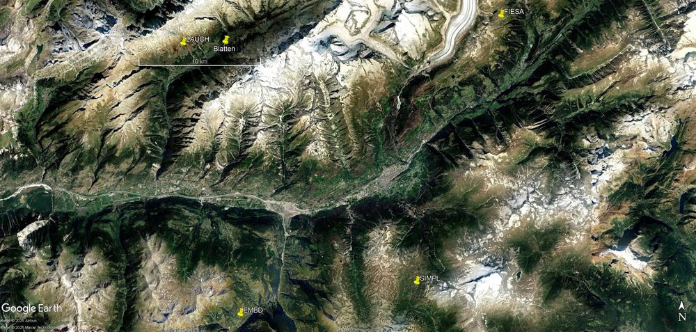
The Blatten landslide was registered on nearby seismometers (station LAUCH is closest, within 10 kms). Spectrogram of the raw waveform shows high energy content in the frequency band 1 - 10 Hz. The spectral signature is similar to those recorded in other parts of the world.


May 29, 2025 at 7:45 PM
The Blatten landslide was registered on nearby seismometers (station LAUCH is closest, within 10 kms). Spectrogram of the raw waveform shows high energy content in the frequency band 1 - 10 Hz. The spectral signature is similar to those recorded in other parts of the world.