


The Map Room
@maproomblog.com
A blog by @jonathancrowe.net about maps in all their forms, on and off since 2003. maproomblog.com
Email digest: maproomblog.com/about/subscribe
Mastodon: mapstodon.space/@maproomblog
Support via Patreon: patreon.com/jonathancrowe
Email digest: maproomblog.com/about/subscribe
Mastodon: mapstodon.space/@maproomblog
Support via Patreon: patreon.com/jonathancrowe
This week on The Map Room:
StateFace
www.maproomblog.com/2025/11/stat...
Mapping the 2025 (and 2021) Canadian Election Results
www.maproomblog.com/2025/11/mapp...
The Onion Doesn’t Miss
www.maproomblog.com/2025/11/the-...
300,000 Kilometres of Roman Roads
www.maproomblog.com/2025/11/3000...
StateFace
www.maproomblog.com/2025/11/stat...
Mapping the 2025 (and 2021) Canadian Election Results
www.maproomblog.com/2025/11/mapp...
The Onion Doesn’t Miss
www.maproomblog.com/2025/11/the-...
300,000 Kilometres of Roman Roads
www.maproomblog.com/2025/11/3000...
November 14, 2025 at 8:23 PM
This week on The Map Room:
StateFace
www.maproomblog.com/2025/11/stat...
Mapping the 2025 (and 2021) Canadian Election Results
www.maproomblog.com/2025/11/mapp...
The Onion Doesn’t Miss
www.maproomblog.com/2025/11/the-...
300,000 Kilometres of Roman Roads
www.maproomblog.com/2025/11/3000...
StateFace
www.maproomblog.com/2025/11/stat...
Mapping the 2025 (and 2021) Canadian Election Results
www.maproomblog.com/2025/11/mapp...
The Onion Doesn’t Miss
www.maproomblog.com/2025/11/the-...
300,000 Kilometres of Roman Roads
www.maproomblog.com/2025/11/3000...
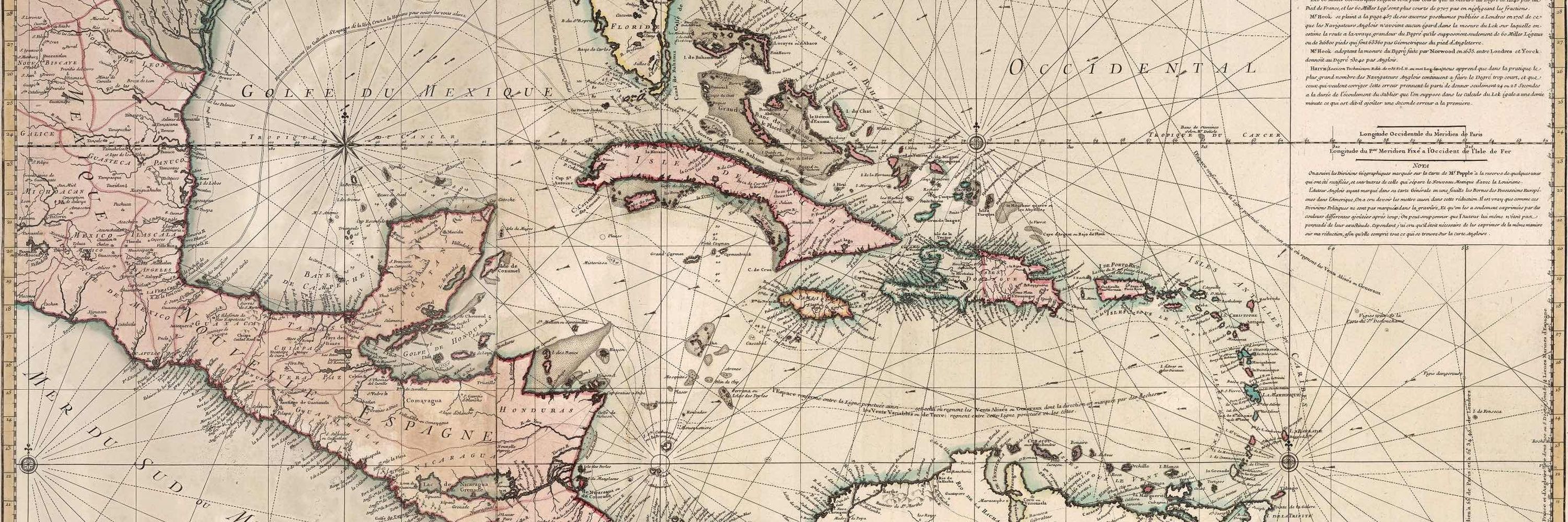
Itiner-e is a comprehensive digital atlas and dataset of the Roman Empire’s entire road network, based on fieldwork, existing maps, published data and remote sensing. It’s an attempt to provide more granular detail than past… More
300,000 Kilometres of Roman Roads
Itiner-e is a comprehensive digital atlas and dataset of the Roman Empire’s entire road network, based on fieldwork, existing maps, published data and remote sensing. It’s an attempt to provide more granular detail than past… More
www.maproomblog.com
November 14, 2025 at 2:39 PM
Itiner-e is a comprehensive digital atlas and dataset of the Roman Empire’s entire road network, based on fieldwork, existing maps, published data and remote sensing. It’s an attempt to provide more granular detail than past… More
The Onion: “An alarming new educational survey has found more than 70% of Americans lack the basic geographic literacy to locate the country, region, or continent they are currently being deported to.”
The Onion Doesn’t Miss
The Onion: “An alarming new educational survey has found more than 70% of Americans lack the basic geographic literacy to locate the country, region, or continent they are currently being deported to.”
www.maproomblog.com
November 13, 2025 at 1:18 PM
The Onion: “An alarming new educational survey has found more than 70% of Americans lack the basic geographic literacy to locate the country, region, or continent they are currently being deported to.”
Reposted by The Map Room


Reposted by The Map Room

Study Finds Most Americans Can't Find Where They Are Being Deported On Map
November 11, 2025 at 6:01 PM
Study Finds Most Americans Can't Find Where They Are Being Deported On Map
Jacob Weinbren has mapped the results of the 2025 Canadian federal election at the polling station level, along with the 2021 results so that we can see how the vote changed. Any project of this… More
Mapping the 2025 (and 2021) Canadian Election Results
Jacob Weinbren has mapped the results of the 2025 Canadian federal election at the polling station level, along with the 2021 results so that we can see how the vote changed. Any project of this… More
www.maproomblog.com
November 11, 2025 at 4:09 PM
Jacob Weinbren has mapped the results of the 2025 Canadian federal election at the polling station level, along with the 2021 results so that we can see how the vote changed. Any project of this… More
StateFace is a font made up of tiny state shapes—all 50 U.S. states, plus D.C. and the lower 48 as a whole. M is Idaho, v is Wisconsin and so on. Seems like it’d be… More
StateFace
StateFace is a font made up of tiny state shapes—all 50 U.S. states, plus D.C. and the lower 48 as a whole. M is Idaho, v is Wisconsin and so on. Seems like it’d be… More
www.maproomblog.com
November 11, 2025 at 3:17 PM
StateFace is a font made up of tiny state shapes—all 50 U.S. states, plus D.C. and the lower 48 as a whole. M is Idaho, v is Wisconsin and so on. Seems like it’d be… More
Reposted by The Map Room

canada-election.pages.dev This is my election map of Canada by polling district - interested what you think!
Canadian Election Results 2021-2025
Interactive map showing Canadian federal election results and vote swing analysis between 2021 and 2025
canada-election.pages.dev
November 10, 2025 at 6:24 PM
canada-election.pages.dev This is my election map of Canada by polling district - interested what you think!
Reposted by The Map Room

New to me so sharing -- for those of you who didn't know, there's a font available that gives you tiny US state shapes that can be used as design elements.
it's called State Face, a project by @propublica.org
propublica.github.io/stateface/
(thanks for sharing this, @propublica.org !)
#GISChat
it's called State Face, a project by @propublica.org
propublica.github.io/stateface/
(thanks for sharing this, @propublica.org !)
#GISChat
StateFace
propublica.github.io
November 10, 2025 at 10:26 PM
New to me so sharing -- for those of you who didn't know, there's a font available that gives you tiny US state shapes that can be used as design elements.
it's called State Face, a project by @propublica.org
propublica.github.io/stateface/
(thanks for sharing this, @propublica.org !)
#GISChat
it's called State Face, a project by @propublica.org
propublica.github.io/stateface/
(thanks for sharing this, @propublica.org !)
#GISChat
Reposted by The Map Room

Discount bundles on allllll published 50 Maps books: 10% off if you buy one, 20% off if you buy two, 30% off if you buy three, 40% off if you buy four, and 50% off if you buy five. Stock up for the holidays!

November 11, 2025 at 1:36 AM
Discount bundles on allllll published 50 Maps books: 10% off if you buy one, 20% off if you buy two, 30% off if you buy three, 40% off if you buy four, and 50% off if you buy five. Stock up for the holidays!
Reposted by The Map Room

Do I know any Indigenous folks who make maps? Got a request for a paid design/cartography job and it'd be rad if I could connect you with them.
November 8, 2025 at 1:01 AM
Do I know any Indigenous folks who make maps? Got a request for a paid design/cartography job and it'd be rad if I could connect you with them.
Reposted by The Map Room

Researchers used archaeological & historical records,topographic maps & satellite imagery to create Itiner-e,a new high-resolution digital dataset & map of the Roman Empire’s roads around 150 AD. It charts 185,896 miles (299,171 km) of roads across almost 1,544,409 square miles (4,000,000 square km)

The Roman Empire’s Entire Road Network Just Got Mapped, and It's Mind-Blowing
A new study identified over 68,000 more miles of ancient Roman roads than were previously known.
gizmodo.com
November 8, 2025 at 5:00 PM
Researchers used archaeological & historical records,topographic maps & satellite imagery to create Itiner-e,a new high-resolution digital dataset & map of the Roman Empire’s roads around 150 AD. It charts 185,896 miles (299,171 km) of roads across almost 1,544,409 square miles (4,000,000 square km)
Reposted by The Map Room
In our latest blog post, we share our philosophy of dark mode basemaps. What are dark maps good for, and why might you need one? How do you design a dark mode map that is both beautiful and functional? All this and more, now on the blog at stamen.com/stamens-dark...


November 7, 2025 at 5:38 PM
In our latest blog post, we share our philosophy of dark mode basemaps. What are dark maps good for, and why might you need one? How do you design a dark mode map that is both beautiful and functional? All this and more, now on the blog at stamen.com/stamens-dark...
This week on The Map Room:
Ireland: Mapping the Island
www.maproomblog.com/2025/11/irel...
More on Secret Maps
www.maproomblog.com/2025/11/more...
Ireland: Mapping the Island
www.maproomblog.com/2025/11/irel...
More on Secret Maps
www.maproomblog.com/2025/11/more...
November 7, 2025 at 8:06 PM
This week on The Map Room:
Ireland: Mapping the Island
www.maproomblog.com/2025/11/irel...
More on Secret Maps
www.maproomblog.com/2025/11/more...
Ireland: Mapping the Island
www.maproomblog.com/2025/11/irel...
More on Secret Maps
www.maproomblog.com/2025/11/more...
Doug Specht has a piece about the British Library’s exhibition Secret Maps in The Conversation. “The exhibition does not shy away from difficult topics. Maps tracing the infrastructure of apartheid, or those produced to facilitate… More
More on Secret Maps
Doug Specht has a piece about the British Library’s exhibition Secret Maps in The Conversation. “The exhibition does not shy away from difficult topics. Maps tracing the infrastructure of apartheid, or those produced to facilitate… More
www.maproomblog.com
November 4, 2025 at 1:08 PM
Doug Specht has a piece about the British Library’s exhibition Secret Maps in The Conversation. “The exhibition does not shy away from difficult topics. Maps tracing the infrastructure of apartheid, or those produced to facilitate… More
Reposted by The Map Room

Maps have always both granted power and threatened it, depending on who controls the data, the scale and the narrative.

Secret Maps at the British Library reconsiders the lines that shape our world
Maps have always both granted power and threatened it, depending on who controls the data, the scale and the narrative.
tcnv.link
November 3, 2025 at 6:54 PM
Maps have always both granted power and threatened it, depending on who controls the data, the scale and the narrative.
RTÉ has published an excerpt from Ireland: Mapping the Island by Joseph Brady and Paul Ferguson, the latest book of cartographic histories published by Birlinn (though Birlinn’s website seems to be offline at the moment).… More
Ireland: Mapping the Island
RTÉ has published an excerpt from Ireland: Mapping the Island by Joseph Brady and Paul Ferguson, the latest book of cartographic histories published by Birlinn (though Birlinn’s website seems to be offline at the moment).… More
www.maproomblog.com
November 3, 2025 at 2:43 PM
RTÉ has published an excerpt from Ireland: Mapping the Island by Joseph Brady and Paul Ferguson, the latest book of cartographic histories published by Birlinn (though Birlinn’s website seems to be offline at the moment).… More
Belt has recently been publishing a number of “[Midwest City] in 50 Maps” titles, which this presumably impacts.

I received this mail from Arcadia Publishing, the company which now owns Belt Publishing, who originally published my book in 2022.
Belt's authors are not the sort of people who are gonna be cool with this. I feel really bad for whoever is answering the emails at Arcadia next week.
Belt's authors are not the sort of people who are gonna be cool with this. I feel really bad for whoever is answering the emails at Arcadia next week.

November 1, 2025 at 11:45 AM
Belt has recently been publishing a number of “[Midwest City] in 50 Maps” titles, which this presumably impacts.
Reposted by The Map Room

It's been a long journey (>1 year since I began), but there's finallt a public release of the oblique hachures method. With many thanks to @southarrowmaps.co.nz, who significantly refined the methodology from what I began with.
Writeup (w/ a link to the script): docs.google.com/document/d/1...
Writeup (w/ a link to the script): docs.google.com/document/d/1...


November 1, 2025 at 2:24 AM
It's been a long journey (>1 year since I began), but there's finallt a public release of the oblique hachures method. With many thanks to @southarrowmaps.co.nz, who significantly refined the methodology from what I began with.
Writeup (w/ a link to the script): docs.google.com/document/d/1...
Writeup (w/ a link to the script): docs.google.com/document/d/1...
I didn’t put two and two together. Secret Maps, the British Library exhibition (previously), has an accompanying book, because British Library exhibitions invariably come with books. And that book was already listed on my Map… More
Secret Maps, the Book
I didn’t put two and two together. Secret Maps, the British Library exhibition (previously), has an accompanying book, because British Library exhibitions invariably come with books. And that book was already listed on my Map… More
www.maproomblog.com
October 31, 2025 at 12:23 PM
I didn’t put two and two together. Secret Maps, the British Library exhibition (previously), has an accompanying book, because British Library exhibitions invariably come with books. And that book was already listed on my Map… More
Viabundus is an online map of medieval Europe. Viabundus is a freely accessible online street map of late medieval and early modern northern Europe (1350-1650). Originally conceived as the digitisation of Friedrich Bruns and Hugo… More
A Street Map of Early Modern Europe
Viabundus is an online map of medieval Europe. Viabundus is a freely accessible online street map of late medieval and early modern northern Europe (1350-1650). Originally conceived as the digitisation of Friedrich Bruns and Hugo… More
www.maproomblog.com
October 27, 2025 at 2:28 PM
Viabundus is an online map of medieval Europe. Viabundus is a freely accessible online street map of late medieval and early modern northern Europe (1350-1650). Originally conceived as the digitisation of Friedrich Bruns and Hugo… More
A new exhibition opened at the British Library this weekend: Secret Maps. Maps have always been more than just tools for navigation – in the hand of governments, groups and individuals, maps create and control… More
New British Library Exhibition: Secret Maps
A new exhibition opened at the British Library this weekend: Secret Maps. Maps have always been more than just tools for navigation – in the hand of governments, groups and individuals, maps create and control… More
www.maproomblog.com
October 26, 2025 at 1:04 PM
A new exhibition opened at the British Library this weekend: Secret Maps. Maps have always been more than just tools for navigation – in the hand of governments, groups and individuals, maps create and control… More
An update on ads coming to Apple Maps. AppleInsider, citing a paywalled report from Mark Gurman’s Power On newsletter: “[T]he decision has been taken to move ahead with the project. The claim is that starting… More
Ads Coming to Apple Maps: Report
An update on ads coming to Apple Maps. AppleInsider, citing a paywalled report from Mark Gurman’s Power On newsletter: “[T]he decision has been taken to move ahead with the project. The claim is that starting… More
www.maproomblog.com
October 26, 2025 at 12:51 PM
An update on ads coming to Apple Maps. AppleInsider, citing a paywalled report from Mark Gurman’s Power On newsletter: “[T]he decision has been taken to move ahead with the project. The claim is that starting… More
Reposted by The Map Room

Secret Maps opens today! 🤫 🗺️
From medieval manuscripts to Cold War espionage, our new exhibition explores how maps have hidden as much as they revealed for over 600 years.
Book now: bit.ly/BLSecretMaps
From medieval manuscripts to Cold War espionage, our new exhibition explores how maps have hidden as much as they revealed for over 600 years.
Book now: bit.ly/BLSecretMaps
October 24, 2025 at 12:26 PM
Secret Maps opens today! 🤫 🗺️
From medieval manuscripts to Cold War espionage, our new exhibition explores how maps have hidden as much as they revealed for over 600 years.
Book now: bit.ly/BLSecretMaps
From medieval manuscripts to Cold War espionage, our new exhibition explores how maps have hidden as much as they revealed for over 600 years.
Book now: bit.ly/BLSecretMaps
Reposted by The Map Room

Our next season for The Oxford Seminars in Cartography ... #TOSCA @bodleian.ox.ac.uk @oxfordgeography.bsky.social Register at: visit.bodleian.ox.ac.uk/tosca
More info at: www.bodleian.ox.ac.uk/maps/tosca @bcsmaps.bsky.social @ordnancesurvey.bsky.social
1st speaker is @drpragyaagarwal.bsky.social
More info at: www.bodleian.ox.ac.uk/maps/tosca @bcsmaps.bsky.social @ordnancesurvey.bsky.social
1st speaker is @drpragyaagarwal.bsky.social

October 24, 2025 at 2:02 PM
Our next season for The Oxford Seminars in Cartography ... #TOSCA @bodleian.ox.ac.uk @oxfordgeography.bsky.social Register at: visit.bodleian.ox.ac.uk/tosca
More info at: www.bodleian.ox.ac.uk/maps/tosca @bcsmaps.bsky.social @ordnancesurvey.bsky.social
1st speaker is @drpragyaagarwal.bsky.social
More info at: www.bodleian.ox.ac.uk/maps/tosca @bcsmaps.bsky.social @ordnancesurvey.bsky.social
1st speaker is @drpragyaagarwal.bsky.social