


Daniel Huffman
@pinakographos.bsky.social
An arboreal, poly, gender non-participant mapmaker.
• Portfolio & tutorials: somethingaboutmaps.com.
• Prints: https://somethingaboutmaps.com/Storefront
• You can support my art & teaching at http://patreon.com/pinakographos.
• Portfolio & tutorials: somethingaboutmaps.com.
• Prints: https://somethingaboutmaps.com/Storefront
• You can support my art & teaching at http://patreon.com/pinakographos.
Pinned
Daniel Huffman
@pinakographos.bsky.social
· Nov 11
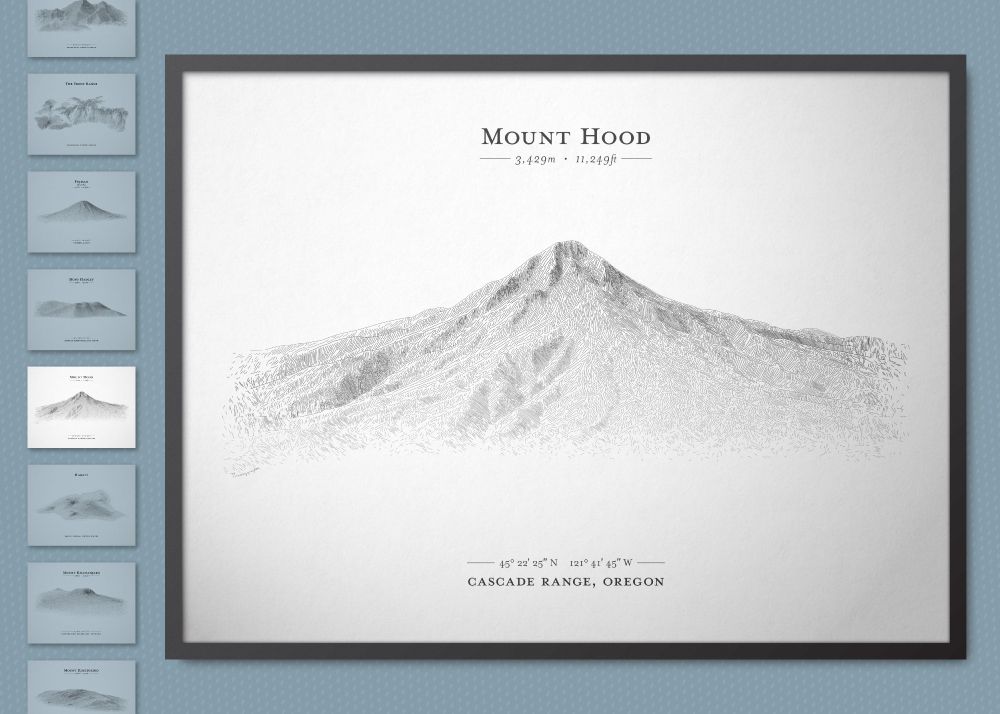


I arrive here having finished a major, multi-month project: creating a posters in a hachure style reminiscent of centuries past. Have a look: terrainlines.etsy.com.
There's a free ebook, too! somethingaboutmaps.wordpress.com/2024/10/31/a...
If you could share them around, I would be grateful!
There's a free ebook, too! somethingaboutmaps.wordpress.com/2024/10/31/a...
If you could share them around, I would be grateful!
Reposted by Daniel Huffman

I've joined the jolly Independent Map Sellers and let me tell you, there are some fantastic gifts here! I have a few prints available (heads up Chicago fans, Wendell Berry fans) ... and I'm going to be leaving town, so order by Dec. 3 for delivery before Christmas. 🗺️🎁 mapartists.org

Independent Map Sellers
A shopping guide offered by the Independent Map Artists
mapartists.org
November 28, 2025 at 5:09 PM
I've joined the jolly Independent Map Sellers and let me tell you, there are some fantastic gifts here! I have a few prints available (heads up Chicago fans, Wendell Berry fans) ... and I'm going to be leaving town, so order by Dec. 3 for delivery before Christmas. 🗺️🎁 mapartists.org
Now up to 51!
Do you like #maps? The Independent Map Artists (mapartists.org) has hit a big milestone and now has 50(!) members, all interested in helping with your holiday shopping. Hundreds of maps & mappy goods, straight from small businesses.
Connecting creators & customers is hard; please consider sharing.
Connecting creators & customers is hard; please consider sharing.


November 27, 2025 at 11:30 PM
Now up to 51!
Reposted by Daniel Huffman

Almost anything can be treated as a map. Projections, charts, and diagrams are all ways of flattening the world so we can understand.
But the real magic happens when we enjoy those maps together. MAPS FOR KIDS is here! Let's meet our three maps: visionarypress.com/pages/maps-f...
But the real magic happens when we enjoy those maps together. MAPS FOR KIDS is here! Let's meet our three maps: visionarypress.com/pages/maps-f...

Maps for Kids
Celebrate information graphics!
visionarypress.com
November 25, 2025 at 4:19 PM
Almost anything can be treated as a map. Projections, charts, and diagrams are all ways of flattening the world so we can understand.
But the real magic happens when we enjoy those maps together. MAPS FOR KIDS is here! Let's meet our three maps: visionarypress.com/pages/maps-f...
But the real magic happens when we enjoy those maps together. MAPS FOR KIDS is here! Let's meet our three maps: visionarypress.com/pages/maps-f...
Reposted by Daniel Huffman
Do you like #maps? The Independent Map Artists (mapartists.org) has hit a big milestone and now has 50(!) members, all interested in helping with your holiday shopping. Hundreds of maps & mappy goods, straight from small businesses.
Connecting creators & customers is hard; please consider sharing.
Connecting creators & customers is hard; please consider sharing.
November 22, 2025 at 6:15 PM
Do you like #maps? The Independent Map Artists (mapartists.org) has hit a big milestone and now has 50(!) members, all interested in helping with your holiday shopping. Hundreds of maps & mappy goods, straight from small businesses.
Connecting creators & customers is hard; please consider sharing.
Connecting creators & customers is hard; please consider sharing.
Long version: somethingaboutmaps.wordpress.com/2011/03/02/o...
Short version: Maps gave me a mental escape from a life mired in deep depression, one brought on by the confluence of an abusive relationship, a move away from home, and a disastrous attempt to avoid adulthood by going back to school.
Short version: Maps gave me a mental escape from a life mired in deep depression, one brought on by the confluence of an abusive relationship, a move away from home, and a disastrous attempt to avoid adulthood by going back to school.


November 23, 2025 at 12:44 AM
Long version: somethingaboutmaps.wordpress.com/2011/03/02/o...
Short version: Maps gave me a mental escape from a life mired in deep depression, one brought on by the confluence of an abusive relationship, a move away from home, and a disastrous attempt to avoid adulthood by going back to school.
Short version: Maps gave me a mental escape from a life mired in deep depression, one brought on by the confluence of an abusive relationship, a move away from home, and a disastrous attempt to avoid adulthood by going back to school.
Do you like #maps? The Independent Map Artists (mapartists.org) has hit a big milestone and now has 50(!) members, all interested in helping with your holiday shopping. Hundreds of maps & mappy goods, straight from small businesses.
Connecting creators & customers is hard; please consider sharing.
Connecting creators & customers is hard; please consider sharing.
November 22, 2025 at 6:15 PM
Do you like #maps? The Independent Map Artists (mapartists.org) has hit a big milestone and now has 50(!) members, all interested in helping with your holiday shopping. Hundreds of maps & mappy goods, straight from small businesses.
Connecting creators & customers is hard; please consider sharing.
Connecting creators & customers is hard; please consider sharing.
Reposted by Daniel Huffman

By request, here's a thread of books that I think make excellent gifts this holiday season (obviously they're cartographically inclined, you know me)
1. Best anthology
"All Over the Map" by Betsy Mason and Greg Miller
A gorgeous, full color history of maps mind-bending maps from around the world.
1. Best anthology
"All Over the Map" by Betsy Mason and Greg Miller
A gorgeous, full color history of maps mind-bending maps from around the world.
November 21, 2025 at 7:35 PM
By request, here's a thread of books that I think make excellent gifts this holiday season (obviously they're cartographically inclined, you know me)
1. Best anthology
"All Over the Map" by Betsy Mason and Greg Miller
A gorgeous, full color history of maps mind-bending maps from around the world.
1. Best anthology
"All Over the Map" by Betsy Mason and Greg Miller
A gorgeous, full color history of maps mind-bending maps from around the world.
Reposted by Daniel Huffman

WE :: There Is No Us or Them
Letterpress print using #blox modular type. Printed on #kozo and mounted #chine-collé in a small #LimitedEdition on Somerset Velvet.
#toMake press in #Missoula #aRealPlace #printmaking
Letterpress print using #blox modular type. Printed on #kozo and mounted #chine-collé in a small #LimitedEdition on Somerset Velvet.
#toMake press in #Missoula #aRealPlace #printmaking


November 21, 2025 at 3:21 PM
WE :: There Is No Us or Them
Letterpress print using #blox modular type. Printed on #kozo and mounted #chine-collé in a small #LimitedEdition on Somerset Velvet.
#toMake press in #Missoula #aRealPlace #printmaking
Letterpress print using #blox modular type. Printed on #kozo and mounted #chine-collé in a small #LimitedEdition on Somerset Velvet.
#toMake press in #Missoula #aRealPlace #printmaking
Reposted by Daniel Huffman

For Day 11 of the #30DayMapChallenge's prompt "Minimal" we made a VERY quick map showing off one of @pinakographos.bsky.social's Project Linework handcrafted vector linework files: Geo-Metro. If you haven't found this resource yet, it's a fun one to find uses for (www.projectlinework.org)!

November 21, 2025 at 4:11 AM
For Day 11 of the #30DayMapChallenge's prompt "Minimal" we made a VERY quick map showing off one of @pinakographos.bsky.social's Project Linework handcrafted vector linework files: Geo-Metro. If you haven't found this resource yet, it's a fun one to find uses for (www.projectlinework.org)!
Someone revive this projection, please.
Apparently it had its own custom projection! As far as I can tell, the Dudley Projection also faded into obscurity, as I find no other reference to it.

November 21, 2025 at 12:17 AM
Someone revive this projection, please.
Reminiscing. When I started making maps as a hobby ca. 2005, I used Map Maker Gratis, a program that faded away long ago. Luckily the Internet Archive remembers (web.archive.org/web/20060424...). Alas, I can't find the maps I made with it, except one. I am still proud of figuring out how to make it.


November 20, 2025 at 10:22 PM
Reminiscing. When I started making maps as a hobby ca. 2005, I used Map Maker Gratis, a program that faded away long ago. Luckily the Internet Archive remembers (web.archive.org/web/20060424...). Alas, I can't find the maps I made with it, except one. I am still proud of figuring out how to make it.
Reposted by Daniel Huffman
I just obtained a (red!) shipping label printer. To celebrate & give me a reason to actually use it, I am discounting "Landforms of Michigan" by 25% for the next week (now only $18.77).
somethingaboutmaps.bigcartel.com/product/the-...
Take a tour: somethingaboutmaps.wordpress.com/2021/12/06/l...
somethingaboutmaps.bigcartel.com/product/the-...
Take a tour: somethingaboutmaps.wordpress.com/2021/12/06/l...


November 18, 2025 at 9:14 PM
I just obtained a (red!) shipping label printer. To celebrate & give me a reason to actually use it, I am discounting "Landforms of Michigan" by 25% for the next week (now only $18.77).
somethingaboutmaps.bigcartel.com/product/the-...
Take a tour: somethingaboutmaps.wordpress.com/2021/12/06/l...
somethingaboutmaps.bigcartel.com/product/the-...
Take a tour: somethingaboutmaps.wordpress.com/2021/12/06/l...
Reposted by Daniel Huffman
I am also celebrating by finally organizing my #cyanotype misprints and having another one of my irregularly-scheduled "pay what you want" sales. Please consider giving a home to one of these less-than-perfect hand-printed pieces. Some have scorch marks!
docs.google.com/document/d/1...
docs.google.com/document/d/1...


November 18, 2025 at 9:18 PM
I am also celebrating by finally organizing my #cyanotype misprints and having another one of my irregularly-scheduled "pay what you want" sales. Please consider giving a home to one of these less-than-perfect hand-printed pieces. Some have scorch marks!
docs.google.com/document/d/1...
docs.google.com/document/d/1...
This cat will be improving her data visualization skills in no time.

November 20, 2025 at 4:30 AM
This cat will be improving her data visualization skills in no time.
Reposted by Daniel Huffman
You there, boy! What day is this?
Why sir, it's GIS Day!
My God, they did it all in one night! Say, boy! Do you know the Map Center in Pawtucket?
The one with the globe in the window that's as big as I am?
Sharp lad, that's the one! Here's my Venmo handle just like, charge me whatever it costs
Why sir, it's GIS Day!
My God, they did it all in one night! Say, boy! Do you know the Map Center in Pawtucket?
The one with the globe in the window that's as big as I am?
Sharp lad, that's the one! Here's my Venmo handle just like, charge me whatever it costs
November 19, 2025 at 3:53 PM
You there, boy! What day is this?
Why sir, it's GIS Day!
My God, they did it all in one night! Say, boy! Do you know the Map Center in Pawtucket?
The one with the globe in the window that's as big as I am?
Sharp lad, that's the one! Here's my Venmo handle just like, charge me whatever it costs
Why sir, it's GIS Day!
My God, they did it all in one night! Say, boy! Do you know the Map Center in Pawtucket?
The one with the globe in the window that's as big as I am?
Sharp lad, that's the one! Here's my Venmo handle just like, charge me whatever it costs
Reposted by Daniel Huffman
I made a map of all the places in New England that I'm giving a talk at in the next 8 months. If I'm not coming to a town near you, ask your local library to reach out. felt.com/map/Library-...

Library Talks – Felt
The only cloud-native GIS platform.
felt.com
November 18, 2025 at 9:19 PM
I made a map of all the places in New England that I'm giving a talk at in the next 8 months. If I'm not coming to a town near you, ask your local library to reach out. felt.com/map/Library-...
I am also celebrating by finally organizing my #cyanotype misprints and having another one of my irregularly-scheduled "pay what you want" sales. Please consider giving a home to one of these less-than-perfect hand-printed pieces. Some have scorch marks!
docs.google.com/document/d/1...
docs.google.com/document/d/1...
November 18, 2025 at 9:18 PM
I am also celebrating by finally organizing my #cyanotype misprints and having another one of my irregularly-scheduled "pay what you want" sales. Please consider giving a home to one of these less-than-perfect hand-printed pieces. Some have scorch marks!
docs.google.com/document/d/1...
docs.google.com/document/d/1...
I just obtained a (red!) shipping label printer. To celebrate & give me a reason to actually use it, I am discounting "Landforms of Michigan" by 25% for the next week (now only $18.77).
somethingaboutmaps.bigcartel.com/product/the-...
Take a tour: somethingaboutmaps.wordpress.com/2021/12/06/l...
somethingaboutmaps.bigcartel.com/product/the-...
Take a tour: somethingaboutmaps.wordpress.com/2021/12/06/l...
November 18, 2025 at 9:14 PM
I just obtained a (red!) shipping label printer. To celebrate & give me a reason to actually use it, I am discounting "Landforms of Michigan" by 25% for the next week (now only $18.77).
somethingaboutmaps.bigcartel.com/product/the-...
Take a tour: somethingaboutmaps.wordpress.com/2021/12/06/l...
somethingaboutmaps.bigcartel.com/product/the-...
Take a tour: somethingaboutmaps.wordpress.com/2021/12/06/l...
Spent a bit of time this evening perusing one of my favorites: The Barrington Atlas of the Greek and Roman World. Fell in love with it at the campus library in college, and was lucky enough to find (and afford) a banged-up copy soon after graduation.

November 18, 2025 at 5:47 AM
Spent a bit of time this evening perusing one of my favorites: The Barrington Atlas of the Greek and Roman World. Fell in love with it at the campus library in college, and was lucky enough to find (and afford) a banged-up copy soon after graduation.
Reposted by Daniel Huffman

This week on The Map Room:
StateFace
www.maproomblog.com/2025/11/stat...
Mapping the 2025 (and 2021) Canadian Election Results
www.maproomblog.com/2025/11/mapp...
The Onion Doesn’t Miss
www.maproomblog.com/2025/11/the-...
300,000 Kilometres of Roman Roads
www.maproomblog.com/2025/11/3000...
StateFace
www.maproomblog.com/2025/11/stat...
Mapping the 2025 (and 2021) Canadian Election Results
www.maproomblog.com/2025/11/mapp...
The Onion Doesn’t Miss
www.maproomblog.com/2025/11/the-...
300,000 Kilometres of Roman Roads
www.maproomblog.com/2025/11/3000...
November 14, 2025 at 8:23 PM
This week on The Map Room:
StateFace
www.maproomblog.com/2025/11/stat...
Mapping the 2025 (and 2021) Canadian Election Results
www.maproomblog.com/2025/11/mapp...
The Onion Doesn’t Miss
www.maproomblog.com/2025/11/the-...
300,000 Kilometres of Roman Roads
www.maproomblog.com/2025/11/3000...
StateFace
www.maproomblog.com/2025/11/stat...
Mapping the 2025 (and 2021) Canadian Election Results
www.maproomblog.com/2025/11/mapp...
The Onion Doesn’t Miss
www.maproomblog.com/2025/11/the-...
300,000 Kilometres of Roman Roads
www.maproomblog.com/2025/11/3000...
As a general reminder: if you see an item in my portfolio (somethingaboutmaps.com/Client-Work), and you want to know more about how I made it, I can usually send my Illustrator/Photoshop files to you for dissection.

November 13, 2025 at 10:31 PM
As a general reminder: if you see an item in my portfolio (somethingaboutmaps.com/Client-Work), and you want to know more about how I made it, I can usually send my Illustrator/Photoshop files to you for dissection.
Reposted by Daniel Huffman
Another beautiful atlas saved from recycling. This one appears to be a guide for boating down a river in Belgium? Love the bridge illustrations.


November 13, 2025 at 5:07 PM
Another beautiful atlas saved from recycling. This one appears to be a guide for boating down a river in Belgium? Love the bridge illustrations.
Reposted by Daniel Huffman
My favorite maps are the ones that show me something new in a striking way. That takes science, data and math but also creativity and a certain visual charisma that is really hard to learn without playing a bit. Poetry is a great way to stretch out, take a fun break and return to work refreshed.
November 12, 2025 at 10:30 PM
My favorite maps are the ones that show me something new in a striking way. That takes science, data and math but also creativity and a certain visual charisma that is really hard to learn without playing a bit. Poetry is a great way to stretch out, take a fun break and return to work refreshed.
Reposted by Daniel Huffman

In the century leading up to 1975, nearly 6000 freighters went down in the Great Lakes.
The Edmund Fitzgerald was the last.
The last. In 50 years, not a single commercial freighter has been lost in the Great Lakes.
Why?
It's NOAA. Of course it's NOAA.
The Edmund Fitzgerald was the last.
The last. In 50 years, not a single commercial freighter has been lost in the Great Lakes.
Why?
It's NOAA. Of course it's NOAA.
November 11, 2025 at 1:50 AM
In the century leading up to 1975, nearly 6000 freighters went down in the Great Lakes.
The Edmund Fitzgerald was the last.
The last. In 50 years, not a single commercial freighter has been lost in the Great Lakes.
Why?
It's NOAA. Of course it's NOAA.
The Edmund Fitzgerald was the last.
The last. In 50 years, not a single commercial freighter has been lost in the Great Lakes.
Why?
It's NOAA. Of course it's NOAA.
Reposted by Daniel Huffman

"And all that remains is the faces and the names of the wives and the sons and the daughters"
Beautiful cover of Fitzgerald by Ross Thorn, recorded this morning on the shores of Lake Superior.
www.instagram.com/reel/DQ4hq80...
Beautiful cover of Fitzgerald by Ross Thorn, recorded this morning on the shores of Lake Superior.
www.instagram.com/reel/DQ4hq80...
Login • Instagram
Welcome back to Instagram. Sign in to check out what your friends, family & interests have been capturing & sharing around the world.
www.instagram.com
November 10, 2025 at 5:40 PM
"And all that remains is the faces and the names of the wives and the sons and the daughters"
Beautiful cover of Fitzgerald by Ross Thorn, recorded this morning on the shores of Lake Superior.
www.instagram.com/reel/DQ4hq80...
Beautiful cover of Fitzgerald by Ross Thorn, recorded this morning on the shores of Lake Superior.
www.instagram.com/reel/DQ4hq80...