


David Roth
@drmetwatch.bsky.social
Meteorologist. Into weather records. Soft spot for subtropical 🌀. 😻 and nature imagery, too.
Pinned
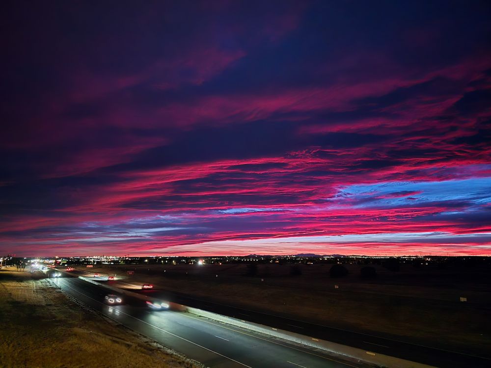
1001 cyclone near the Virginia Capes


December 2, 2025 at 7:12 PM
1001 cyclone near the Virginia Capes
Reposted by David Roth
Happy anniversary to the snow squall
December 2, 2025 at 6:45 PM
Happy anniversary to the snow squall
Reposted by David Roth

AIFS Ensemble plots are now available on PolarWx for a limited number of map projections: polarwx.com/models/?mode...


November 28, 2025 at 6:20 PM
AIFS Ensemble plots are now available on PolarWx for a limited number of map projections: polarwx.com/models/?mode...
Reposted by David Roth

We’re here for the inversions.

November 24, 2025 at 9:23 PM
We’re here for the inversions.
Reposted by David Roth

Rainfall reports and radar estimates (shaded map) are displayed below for the Southern Plains heavy rain event. Several locations saw 5-7 " rainfall accumulations, leading to several flash flood warnings and a flash flood emergency.

November 21, 2025 at 5:07 PM
Rainfall reports and radar estimates (shaded map) are displayed below for the Southern Plains heavy rain event. Several locations saw 5-7 " rainfall accumulations, leading to several flash flood warnings and a flash flood emergency.
Interesting convective feature north of the Leewards

November 18, 2025 at 9:18 PM
Interesting convective feature north of the Leewards
Reposted by David Roth

Officially a top-5 latest first snow in Denver as of today.
We are a lock to move into the top-3, though we may finally (and probably marginally) snap this skid later this week.
#COwx
We are a lock to move into the top-3, though we may finally (and probably marginally) snap this skid later this week.
#COwx

November 16, 2025 at 4:08 PM
Officially a top-5 latest first snow in Denver as of today.
We are a lock to move into the top-3, though we may finally (and probably marginally) snap this skid later this week.
#COwx
We are a lock to move into the top-3, though we may finally (and probably marginally) snap this skid later this week.
#COwx
Reposted by David Roth
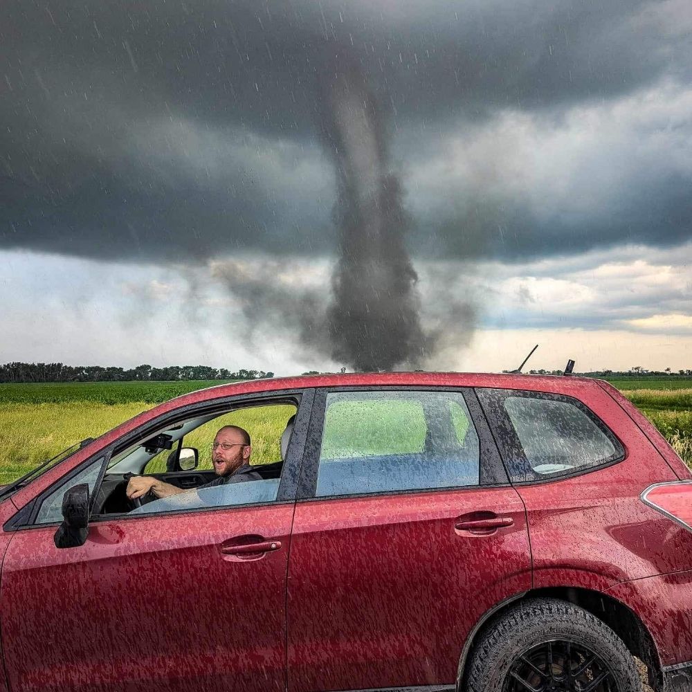
2/2 (Really hope this comes through & not distorted)
I expected it to have a corkscrew motion but not quite - tho the timelapse was at the end of the event.
I’m assuming there was a local rotor that had enough moisture to get some condensation. Curious if anyone else has seen anything like this?
I expected it to have a corkscrew motion but not quite - tho the timelapse was at the end of the event.
I’m assuming there was a local rotor that had enough moisture to get some condensation. Curious if anyone else has seen anything like this?
November 15, 2025 at 12:04 AM
2/2 (Really hope this comes through & not distorted)
I expected it to have a corkscrew motion but not quite - tho the timelapse was at the end of the event.
I’m assuming there was a local rotor that had enough moisture to get some condensation. Curious if anyone else has seen anything like this?
I expected it to have a corkscrew motion but not quite - tho the timelapse was at the end of the event.
I’m assuming there was a local rotor that had enough moisture to get some condensation. Curious if anyone else has seen anything like this?
Reposted by David Roth

Was just hit by a terrain-induced convective shower in San Francisco’s Twin Peaks neighborhood, the first I’ve experienced in my time living here. The marine layer typically limits surface convection along the San Francisco Peninsula, but it’s nonexistent today, making these showers possible. #CAwx


November 14, 2025 at 8:33 PM
Was just hit by a terrain-induced convective shower in San Francisco’s Twin Peaks neighborhood, the first I’ve experienced in my time living here. The marine layer typically limits surface convection along the San Francisco Peninsula, but it’s nonexistent today, making these showers possible. #CAwx
Reposted by David Roth
An unusually strong storm system will bring widespread rain to southern California through Sunday. The period of most concern is tonight through Saturday night when a large area of heavy rain and isolated but potentially severe thunderstorms will bring a moderate risk of...
(1/2)
(1/2)

November 14, 2025 at 5:03 PM
An unusually strong storm system will bring widespread rain to southern California through Sunday. The period of most concern is tonight through Saturday night when a large area of heavy rain and isolated but potentially severe thunderstorms will bring a moderate risk of...
(1/2)
(1/2)
Disturbed weather continues to exist near Central America near the tail end of a front.

November 13, 2025 at 2:01 PM
Disturbed weather continues to exist near Central America near the tail end of a front.
Reposted by David Roth

I'm loving this view tonight!

November 13, 2025 at 3:04 AM
I'm loving this view tonight!
Reposted by David Roth
I may have just witnessed my first aurora from the light pollution of northeast NJ no less

November 12, 2025 at 3:10 AM
I may have just witnessed my first aurora from the light pollution of northeast NJ no less


Reposted by David Roth
Better than anything I saw last year!

November 12, 2025 at 2:47 AM
Better than anything I saw last year!


Reposted by David Roth

Joining the party... Acton, MA

November 12, 2025 at 2:59 AM
Joining the party... Acton, MA
Reposted by David Roth
Another one today
November 11, 2025 at 1:08 AM
Another one today
Reposted by David Roth

I first wrote and cron’d the script that makes these @NWSSPC upper air maps in November 1998. It’s been running and making the twice-daily UA maps for the past 27 years at this URL: www.spc.noaa.gov/obswx/maps/. That’s over 138,000 maps online and it’s still going!
November 10, 2025 at 9:18 PM
I first wrote and cron’d the script that makes these @NWSSPC upper air maps in November 1998. It’s been running and making the twice-daily UA maps for the past 27 years at this URL: www.spc.noaa.gov/obswx/maps/. That’s over 138,000 maps online and it’s still going!
Reposted by David Roth

Reposted by David Roth
The Beaufort Sea, north of Alaska and northwest of Canada, has been slow to freeze over this autumn, with the rate of increase of sea ice extent way below normal since early October. Sea ice is slowly growing and expanding in the Chukchi and Bering Seas. #akwx #Arctic #SeaIce

November 9, 2025 at 6:16 PM
A local Maryland Dwarf Holly has berries now.

November 9, 2025 at 3:31 PM
A local Maryland Dwarf Holly has berries now.
Our first pre 5pm sunset here. It recedes to 4:45 in early December before returning to 5pm January 5.

November 9, 2025 at 3:13 PM
Our first pre 5pm sunset here. It recedes to 4:45 in early December before returning to 5pm January 5.


Reposted by David Roth
