


CJC <3 🇺🇦🌾🚜🌾🇺🇦
@castyman22205.bsky.social
20 year old guy from NJ. Earth sci major at local community college,geosci enthusiast. Reposts/posts stuff related to meteorology,climate science,oceanography,geology,planetary/space science. Atheist. Bi. My philosophical/political views are MINE alone.
Pinned
Thread 🧵 of important science news as it relates to Donald Trump
Below is a 🧵 of recent (since mid-late July) science news as it relates to what Trump is doing to federal science and related topics. This is meant to keep track of his dismantling and also so I myself don’t miss anything. Also my apologies for any repetitiveness.
Reposted by CJC <3 🇺🇦🌾🚜🌾🇺🇦

#WBC issues Excessive Rainfall Discussion (QPF) at Dec 20, 10:47 AM EST ...THERE IS A MARGINAL RISK OF EXCESSIVE RAINFALL IN PORTIONS OF NORTHERN CALIFORNIA|... Link
December 20, 2025 at 3:47 PM
#WBC issues Excessive Rainfall Discussion (QPF) at Dec 20, 10:47 AM EST ...THERE IS A MARGINAL RISK OF EXCESSIVE RAINFALL IN PORTIONS OF NORTHERN CALIFORNIA|... Link
Reposted by CJC <3 🇺🇦🌾🚜🌾🇺🇦

New research presented at #AGU25 shows a computational framework that is helping Sun scientists explore the history and present of the Sun’s activity.

Sunspot Drawings Illuminate 400 Years of Solar Activity - Eos
A new computational framework is helping scientists sift through centuries of scientific illustration of the Sun’s spotty surface.
eos.org
December 20, 2025 at 3:33 PM
New research presented at #AGU25 shows a computational framework that is helping Sun scientists explore the history and present of the Sun’s activity.
Reposted by CJC <3 🇺🇦🌾🚜🌾🇺🇦
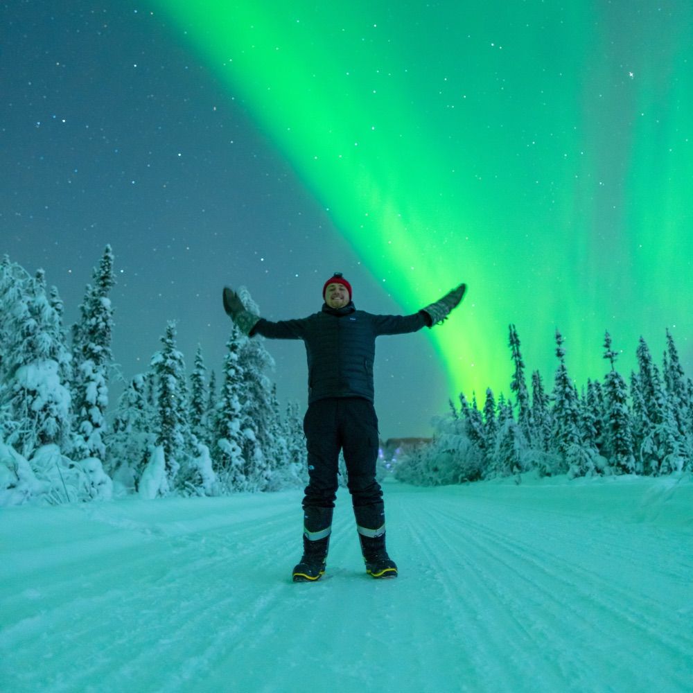
Timelapse of the aurora over North America last night. Real-time THEMIS ASI data are plotted (low-res). There were relatively quiet solar wind data, but aurora was still present at high-latitudes under the auroral oval. Fairbanks saw aurora late in the morning.
December 20, 2025 at 3:35 PM
Timelapse of the aurora over North America last night. Real-time THEMIS ASI data are plotted (low-res). There were relatively quiet solar wind data, but aurora was still present at high-latitudes under the auroral oval. Fairbanks saw aurora late in the morning.
Reposted by CJC <3 🇺🇦🌾🚜🌾🇺🇦
Today, 4 stations in southern China broke Dec records: Ruian 26.8°C, Wenzhou 26.7°C, Changshan 25.4°C, and Luxi 23.9°C. Baoting reached 30.8C.
Furthermore, 35 stations broke mid-December records today, bringing thetotal number of record-breaking stations to 136!
Furthermore, 35 stations broke mid-December records today, bringing thetotal number of record-breaking stations to 136!

December 20, 2025 at 3:41 PM
Today, 4 stations in southern China broke Dec records: Ruian 26.8°C, Wenzhou 26.7°C, Changshan 25.4°C, and Luxi 23.9°C. Baoting reached 30.8C.
Furthermore, 35 stations broke mid-December records today, bringing thetotal number of record-breaking stations to 136!
Furthermore, 35 stations broke mid-December records today, bringing thetotal number of record-breaking stations to 136!
Reposted by CJC <3 🇺🇦🌾🚜🌾🇺🇦

Sunday is the Winter Solstice in the northern hemisphere. The point in the year when daylight is at its shortest
Across the UK, daylight will be in short supply:
Less than 8 hours in the far south 🕑
And under 6 hours in the far north 🕑
Across the UK, daylight will be in short supply:
Less than 8 hours in the far south 🕑
And under 6 hours in the far north 🕑
December 20, 2025 at 3:44 PM
Sunday is the Winter Solstice in the northern hemisphere. The point in the year when daylight is at its shortest
Across the UK, daylight will be in short supply:
Less than 8 hours in the far south 🕑
And under 6 hours in the far north 🕑
Across the UK, daylight will be in short supply:
Less than 8 hours in the far south 🕑
And under 6 hours in the far north 🕑
Reposted by CJC <3 🇺🇦🌾🚜🌾🇺🇦
High temperatures (ºF) in and around Alaska on Friday. Continued cold in the Interior & Yukon Territory. Above normal on the North Slope and west/southwest Alaska. Southeast Alaska very cold, including first Dec daily record low temp at Juneau in 30 years. #akwx #weather @climatologist49.bsky.social

December 20, 2025 at 3:44 PM
High temperatures (ºF) in and around Alaska on Friday. Continued cold in the Interior & Yukon Territory. Above normal on the North Slope and west/southwest Alaska. Southeast Alaska very cold, including first Dec daily record low temp at Juneau in 30 years. #akwx #weather @climatologist49.bsky.social
Reposted by CJC <3 🇺🇦🌾🚜🌾🇺🇦

Sure thing. Here you go.

December 20, 2025 at 3:23 PM
Sure thing. Here you go.
Reposted by CJC <3 🇺🇦🌾🚜🌾🇺🇦

Female House Finch
#BirdsOnFeeders #BirdOfTheDay #birds #photography #birding #WestCoastKin #birdphotography #nature #wildlife
#BirdsOnFeeders #BirdOfTheDay #birds #photography #birding #WestCoastKin #birdphotography #nature #wildlife

December 19, 2025 at 5:38 PM
Female House Finch
#BirdsOnFeeders #BirdOfTheDay #birds #photography #birding #WestCoastKin #birdphotography #nature #wildlife
#BirdsOnFeeders #BirdOfTheDay #birds #photography #birding #WestCoastKin #birdphotography #nature #wildlife
Reposted by CJC <3 🇺🇦🌾🚜🌾🇺🇦

March Afternoon
Mississippi River Gorge
Minneapolis|Saint Paul
Minnesota
Mississippi River Gorge
Minneapolis|Saint Paul
Minnesota

December 20, 2025 at 9:18 AM
March Afternoon
Mississippi River Gorge
Minneapolis|Saint Paul
Minnesota
Mississippi River Gorge
Minneapolis|Saint Paul
Minnesota
Reposted by CJC <3 🇺🇦🌾🚜🌾🇺🇦

The planned launch of the Science and Power Module, NEM, on a Proton rocket will require a custom-built payload arrangement with some record-breaking dimensions.
Exclusive details (subscription): russianspaceweb.com/insider-cont...
Exclusive details (subscription): russianspaceweb.com/insider-cont...

December 19, 2025 at 3:16 PM
The planned launch of the Science and Power Module, NEM, on a Proton rocket will require a custom-built payload arrangement with some record-breaking dimensions.
Exclusive details (subscription): russianspaceweb.com/insider-cont...
Exclusive details (subscription): russianspaceweb.com/insider-cont...
Reposted by CJC <3 🇺🇦🌾🚜🌾🇺🇦
Brown Mountain (Sept 2025)
#Photography #Landscape #Nature #Outdoors #Colorado #Fallorado #Mountains #Nikon #CaptureOne #AffinityPhoto
#Photography #Landscape #Nature #Outdoors #Colorado #Fallorado #Mountains #Nikon #CaptureOne #AffinityPhoto

December 19, 2025 at 5:16 PM
Brown Mountain (Sept 2025)
#Photography #Landscape #Nature #Outdoors #Colorado #Fallorado #Mountains #Nikon #CaptureOne #AffinityPhoto
#Photography #Landscape #Nature #Outdoors #Colorado #Fallorado #Mountains #Nikon #CaptureOne #AffinityPhoto
Reposted by CJC <3 🇺🇦🌾🚜🌾🇺🇦
I like places where a lot is going on, but it’s subtle. Stone, water, moss, distance, weather. Each plays a small part in the bigger picture.
#scape #forestfriday #pnw #photography #landscape #nature #landscapephotography #mountains #naturephotography
#scape #forestfriday #pnw #photography #landscape #nature #landscapephotography #mountains #naturephotography

December 19, 2025 at 12:58 PM
I like places where a lot is going on, but it’s subtle. Stone, water, moss, distance, weather. Each plays a small part in the bigger picture.
#scape #forestfriday #pnw #photography #landscape #nature #landscapephotography #mountains #naturephotography
#scape #forestfriday #pnw #photography #landscape #nature #landscapephotography #mountains #naturephotography
Reposted by CJC <3 🇺🇦🌾🚜🌾🇺🇦
Meanwhile, in Alaska, ... @alaskawx.bsky.social

December 20, 2025 at 3:27 PM
Meanwhile, in Alaska, ... @alaskawx.bsky.social
Reposted by CJC <3 🇺🇦🌾🚜🌾🇺🇦

The members of SpaceX #Crew12 have been announced: Jessica Meir, Jack Hathaway, Sophie Adenot and Andrei Fedyayev, to be launched to the International Space Station in February.
@fr.esa.int @exploration.esa.int @soph-astro.esa.int
@fr.esa.int @exploration.esa.int @soph-astro.esa.int

NASA Shares SpaceX Crew-12 Assignments for Space Station Mission - NASA
As part of NASA’s SpaceX Crew-12 mission, four crew members from three space agencies will launch no earlier than Sunday, Feb. 15, 2026, to the International
www.nasa.gov
December 20, 2025 at 3:25 PM
The members of SpaceX #Crew12 have been announced: Jessica Meir, Jack Hathaway, Sophie Adenot and Andrei Fedyayev, to be launched to the International Space Station in February.
@fr.esa.int @exploration.esa.int @soph-astro.esa.int
@fr.esa.int @exploration.esa.int @soph-astro.esa.int
Reposted by CJC <3 🇺🇦🌾🚜🌾🇺🇦


Reposted by CJC <3 🇺🇦🌾🚜🌾🇺🇦
The month-to-date average temperature for the Contiguous U.S. is now above normal. It will keep going up from here.

December 20, 2025 at 3:21 PM
The month-to-date average temperature for the Contiguous U.S. is now above normal. It will keep going up from here.
Reposted by CJC <3 🇺🇦🌾🚜🌾🇺🇦

A little panorama at sunset last night up on E. Camino Cielo, 4000 feet above Santa Barbara.
#panophotos #Pano #Panorama #Sunset #LaCumbrePeak #SantaBarbara #Photography
#panophotos #Pano #Panorama #Sunset #LaCumbrePeak #SantaBarbara #Photography

December 19, 2025 at 8:27 PM
A little panorama at sunset last night up on E. Camino Cielo, 4000 feet above Santa Barbara.
#panophotos #Pano #Panorama #Sunset #LaCumbrePeak #SantaBarbara #Photography
#panophotos #Pano #Panorama #Sunset #LaCumbrePeak #SantaBarbara #Photography
Reposted by CJC <3 🇺🇦🌾🚜🌾🇺🇦
Dry August Creek Falls
Minnehaha
Minneapolis
Minnesota
Minnehaha
Minneapolis
Minnesota

December 20, 2025 at 7:56 AM
Dry August Creek Falls
Minnehaha
Minneapolis
Minnesota
Minnehaha
Minneapolis
Minnesota
Reposted by CJC <3 🇺🇦🌾🚜🌾🇺🇦
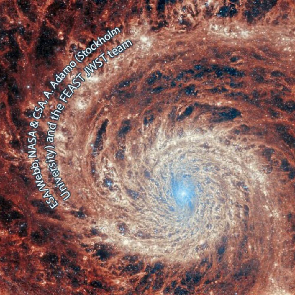
A spiral galaxy, observed with the Apache Point 2.5m Telescope in the SDSS survey.
It is at redshift 0.050 (lookback time 698.4 million years) with coordinates (160.28932, 34.71695).
44 volunteers classified this galaxy in Galaxy Zoo 2.
It is at redshift 0.050 (lookback time 698.4 million years) with coordinates (160.28932, 34.71695).
44 volunteers classified this galaxy in Galaxy Zoo 2.

December 20, 2025 at 3:24 PM
A spiral galaxy, observed with the Apache Point 2.5m Telescope in the SDSS survey.
It is at redshift 0.050 (lookback time 698.4 million years) with coordinates (160.28932, 34.71695).
44 volunteers classified this galaxy in Galaxy Zoo 2.
It is at redshift 0.050 (lookback time 698.4 million years) with coordinates (160.28932, 34.71695).
44 volunteers classified this galaxy in Galaxy Zoo 2.
Reposted by CJC <3 🇺🇦🌾🚜🌾🇺🇦

The fossil record preserves bones, not biodiversity.
But extinction happens at the scale of bacteria, fungi, mosses, microfauna, parasites, soil invertebrates.
Entire kingdoms of life disappear without leaving a mark.
But extinction happens at the scale of bacteria, fungi, mosses, microfauna, parasites, soil invertebrates.
Entire kingdoms of life disappear without leaving a mark.

December 20, 2025 at 2:01 PM
The fossil record preserves bones, not biodiversity.
But extinction happens at the scale of bacteria, fungi, mosses, microfauna, parasites, soil invertebrates.
Entire kingdoms of life disappear without leaving a mark.
But extinction happens at the scale of bacteria, fungi, mosses, microfauna, parasites, soil invertebrates.
Entire kingdoms of life disappear without leaving a mark.
Reposted by CJC <3 🇺🇦🌾🚜🌾🇺🇦

Taos to Durango, US84, Colorado Trees
2025 Photo a Day Project Dec 19 (fr’om 2023)
flic.kr/p/2oPdbho%E2... #photography #colorado #mountains
2025 Photo a Day Project Dec 19 (fr’om 2023)
flic.kr/p/2oPdbho%E2... #photography #colorado #mountains

December 19, 2025 at 12:07 PM
Taos to Durango, US84, Colorado Trees
2025 Photo a Day Project Dec 19 (fr’om 2023)
flic.kr/p/2oPdbho%E2... #photography #colorado #mountains
2025 Photo a Day Project Dec 19 (fr’om 2023)
flic.kr/p/2oPdbho%E2... #photography #colorado #mountains
Reposted by CJC <3 🇺🇦🌾🚜🌾🇺🇦

Forest Friday Aspens
#forestfriday #scape #aspen #october #morningwalk #golden #trees #cedarhillpark #saanich #vancouverisland #britishcolumbia #photography #eastcoastkin #nature #fall
#forestfriday #scape #aspen #october #morningwalk #golden #trees #cedarhillpark #saanich #vancouverisland #britishcolumbia #photography #eastcoastkin #nature #fall

December 19, 2025 at 10:36 PM
Reposted by CJC <3 🇺🇦🌾🚜🌾🇺🇦

#ForestFriday at last...I'd like to walk into these trees until 2026.
#trees #forest #nature #winter #eastcoastkin #photography #Friday #tgif
#trees #forest #nature #winter #eastcoastkin #photography #Friday #tgif

December 19, 2025 at 1:09 PM
#ForestFriday at last...I'd like to walk into these trees until 2026.
#trees #forest #nature #winter #eastcoastkin #photography #Friday #tgif
#trees #forest #nature #winter #eastcoastkin #photography #Friday #tgif
Reposted by CJC <3 🇺🇦🌾🚜🌾🇺🇦


December 20, 2025 at 3:41 AM