


Philip Amies
@amiesphilip.bsky.social
Interested in history, earth science, biology.
Reposted by Philip Amies


Reposted by Philip Amies

🔥ADVANCE ACCESS🔥: What are grana in chloroplasts of vascular plants good for?
doi.org/10.1093/aob/...
doi.org/10.1093/aob/...
November 27, 2025 at 7:05 AM
🔥ADVANCE ACCESS🔥: What are grana in chloroplasts of vascular plants good for?
doi.org/10.1093/aob/...
doi.org/10.1093/aob/...
Reposted by Philip Amies

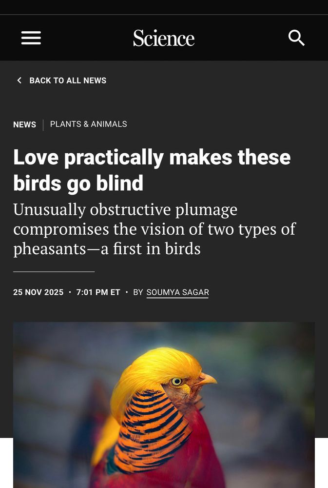
We had a new paper out yesterday in @royalsocietypublishing.org Biology Letters. About how the cranial feathers of male Golden and Lady Amherst’s Pheasants affect their visual fields. Nice to see it picked up The New York Times and Science. Paper link below.


November 27, 2025 at 7:18 AM
We had a new paper out yesterday in @royalsocietypublishing.org Biology Letters. About how the cranial feathers of male Golden and Lady Amherst’s Pheasants affect their visual fields. Nice to see it picked up The New York Times and Science. Paper link below.
First provisional Ancient Woodland Inventory (AWI), compiled in the 1980s based on maps from the 1930s, estimated approximately 0.37 million hectares of ancient woodland in England.
1924 woodland census
cdn.forestresearch.gov.uk/2022/02/cens...
1924 woodland census
cdn.forestresearch.gov.uk/2022/02/cens...
cdn.forestresearch.gov.uk
November 27, 2025 at 7:31 AM
First provisional Ancient Woodland Inventory (AWI), compiled in the 1980s based on maps from the 1930s, estimated approximately 0.37 million hectares of ancient woodland in England.
1924 woodland census
cdn.forestresearch.gov.uk/2022/02/cens...
1924 woodland census
cdn.forestresearch.gov.uk/2022/02/cens...
Reposted by Philip Amies

At late Yangshao culture (5300–4800 BP) settlements in Neolithic China, people built settlements surrounded by circular, often extensive ditch systems. New research suggests they were an intelligent way to collect, store and transport rainwater #WednesdayWisdom
(£) doi.org/10.15184/aqy...
🏺
(£) doi.org/10.15184/aqy...
🏺

November 26, 2025 at 5:35 PM
At late Yangshao culture (5300–4800 BP) settlements in Neolithic China, people built settlements surrounded by circular, often extensive ditch systems. New research suggests they were an intelligent way to collect, store and transport rainwater #WednesdayWisdom
(£) doi.org/10.15184/aqy...
🏺
(£) doi.org/10.15184/aqy...
🏺
@haggewoods.bsky.social kindly shared a review of a new book by Ian Rotherham who has written a number of books on historical ecology. We live with the impacts of converting ancient woodlands to conifer plantations, many NGOs considered ancient
ianswalkonthewildside.wordpress.com/2025/11/25/r...
ianswalkonthewildside.wordpress.com/2025/11/25/r...

Review by Professor Alan Simson of ‘The New Locust Years’
Review by Professor Alan Simson of ‘The New Locust Years’ …….
ianswalkonthewildside.wordpress.com
November 26, 2025 at 5:49 PM
@haggewoods.bsky.social kindly shared a review of a new book by Ian Rotherham who has written a number of books on historical ecology. We live with the impacts of converting ancient woodlands to conifer plantations, many NGOs considered ancient
ianswalkonthewildside.wordpress.com/2025/11/25/r...
ianswalkonthewildside.wordpress.com/2025/11/25/r...
Reposted by Philip Amies

November 13, 2025 at 7:23 PM
Reposted by Philip Amies

Impressive paper with a huge range of techniques applied to answer questions about fossil lichen anatomy.

This paper raises the possibility that lichens had evolved by the late Ordovician, contemporary with earliest vascular plants 🧪⚒️
www.science.org/doi/10.1126/...
www.science.org/doi/10.1126/...

The rise of lichens during the colonization of terrestrial environments
Evidence reveals Spongiophyton as one of the earliest and most widespread lichens in Earth’s history.
www.science.org
November 25, 2025 at 1:53 PM
Impressive paper with a huge range of techniques applied to answer questions about fossil lichen anatomy.
Reposted by Philip Amies

NEW: We cannot continue to pump CO2 into the Atmosphere without re-arranging the Biosphere. Ellen Welti and I analyze datasets from the US Long Term Ecological Research site at Konza Prairie and reveal wholesale reorganization of plant biomass and biogeochemistry, with implications for its food web.

November 24, 2025 at 8:53 PM
NEW: We cannot continue to pump CO2 into the Atmosphere without re-arranging the Biosphere. Ellen Welti and I analyze datasets from the US Long Term Ecological Research site at Konza Prairie and reveal wholesale reorganization of plant biomass and biogeochemistry, with implications for its food web.
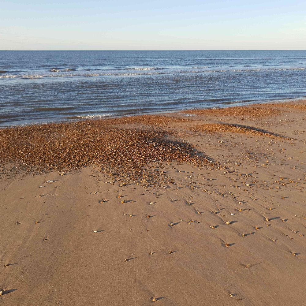
An idiot drove past my home on a bumpy track taking a bomb (he found on the beach) to Hunstanton police station which was then evacuated, the bomb squad then had to transport the bomb, a beach or a field is a safer place to deal with a bomb than around buildings.

It’s happened again!
If you find anything that resembles a grenade, a bomb or anything you think contains explosives - DO NOT take it the police station.
LEAVE IT ALONE and DIAL 999.
It’s potentially dangerous and needs to be checked by experts.
www.bbc.com/news/article...
If you find anything that resembles a grenade, a bomb or anything you think contains explosives - DO NOT take it the police station.
LEAVE IT ALONE and DIAL 999.
It’s potentially dangerous and needs to be checked by experts.
www.bbc.com/news/article...
November 25, 2025 at 7:46 AM
An idiot drove past my home on a bumpy track taking a bomb (he found on the beach) to Hunstanton police station which was then evacuated, the bomb squad then had to transport the bomb, a beach or a field is a safer place to deal with a bomb than around buildings.
Reposted by Philip Amies
There are a lot of sources online that say Shetland is home to the endemic species Edmondston's Chickweed.
This is not the case - instead the island of Unst is the only global site for Cerastium nigrescens var. nigrescens, an endemic *variety* of the Artic Mouse-ear.
This is not the case - instead the island of Unst is the only global site for Cerastium nigrescens var. nigrescens, an endemic *variety* of the Artic Mouse-ear.

November 22, 2025 at 12:08 PM
There are a lot of sources online that say Shetland is home to the endemic species Edmondston's Chickweed.
This is not the case - instead the island of Unst is the only global site for Cerastium nigrescens var. nigrescens, an endemic *variety* of the Artic Mouse-ear.
This is not the case - instead the island of Unst is the only global site for Cerastium nigrescens var. nigrescens, an endemic *variety* of the Artic Mouse-ear.
Reposted by Philip Amies

Third and final Uist trip finished! That's 481 individual Rock Doves ringed/recaptured/resighted during 2025, providing great data to help us understand this population. It's been nice to also get the opportunity to update the community on our project progress. @jezierskimt.bsky.social


November 21, 2025 at 9:21 AM
Third and final Uist trip finished! That's 481 individual Rock Doves ringed/recaptured/resighted during 2025, providing great data to help us understand this population. It's been nice to also get the opportunity to update the community on our project progress. @jezierskimt.bsky.social
Ai the gift which keeps on giving (and presumably all the hackers, scammers), so much thieving everybody protects themselves with Cloudfare, when Cloudfare goes down half the web is down.
November 18, 2025 at 2:10 PM
Ai the gift which keeps on giving (and presumably all the hackers, scammers), so much thieving everybody protects themselves with Cloudfare, when Cloudfare goes down half the web is down.
I was planning to go to Titchwell today, but my wife needed the car, trying to work out if it was better to miss todays Black-browed Albatross while warm at home, or maybe miss it at Titchwell if I had not been seawatching when it flew past.
November 17, 2025 at 1:38 PM
I was planning to go to Titchwell today, but my wife needed the car, trying to work out if it was better to miss todays Black-browed Albatross while warm at home, or maybe miss it at Titchwell if I had not been seawatching when it flew past.
Reposted by Philip Amies

New ditch methane paper out, via my ongoing collaboration with Zhifeng Yan's group at Tianjin University. We show agricultural ditches can affect regional CH4 budgets. agupubs.onlinelibrary.wiley.com/doi/10.1029/...

Diffusive CH4 Emissions From Agricultural Ditches Overshadow CH4 Sinks by Upland Fields
Ditches are potentially important sources of methane (CH4) in agricultural regions, but their CH4 emissions are largely unknown due to data scarcity. Here, we investigated CH4 concentrations and diff...
agupubs.onlinelibrary.wiley.com
November 17, 2025 at 9:30 AM
New ditch methane paper out, via my ongoing collaboration with Zhifeng Yan's group at Tianjin University. We show agricultural ditches can affect regional CH4 budgets. agupubs.onlinelibrary.wiley.com/doi/10.1029/...
Farm viability, if soil characteristics, market access, area, capital/debt is equal then management variance is an important factor.
projectblue.blob.core.windows.net/media/Defaul...
projectblue.blob.core.windows.net/media/Defaul...
projectblue.blob.core.windows.net
November 17, 2025 at 9:00 AM
Farm viability, if soil characteristics, market access, area, capital/debt is equal then management variance is an important factor.
projectblue.blob.core.windows.net/media/Defaul...
projectblue.blob.core.windows.net/media/Defaul...
@moreorloess.bsky.social
With a resistance to collectivisation and land expropriation from large estates small farm holdings stayed small until 1989
www.cambridge.org/core/journal...
With a resistance to collectivisation and land expropriation from large estates small farm holdings stayed small until 1989
www.cambridge.org/core/journal...
Land reform in People’s Poland (1944–89) | Rural History | Cambridge Core
Land reform in People’s Poland (1944–89) - Volume 32 Issue 2
www.cambridge.org
November 17, 2025 at 8:00 AM
@moreorloess.bsky.social
With a resistance to collectivisation and land expropriation from large estates small farm holdings stayed small until 1989
www.cambridge.org/core/journal...
With a resistance to collectivisation and land expropriation from large estates small farm holdings stayed small until 1989
www.cambridge.org/core/journal...
"Woodchat Shrikes spend only three full months on breeding grounds, limiting the window for habitat management. Since they spend most of the year in sub-Saharan Africa, threats in the Sahel—such as rising temperatures, unpredictable rainfall, and land degradation—are critical."

Our last paper describes the spring-accelerated loop-migration of the Woodchat Shrike, tracked with light- and multi-sensor geolocators link.springer.com/article/10.1... #ornithology

November 16, 2025 at 8:23 AM
"Woodchat Shrikes spend only three full months on breeding grounds, limiting the window for habitat management. Since they spend most of the year in sub-Saharan Africa, threats in the Sahel—such as rising temperatures, unpredictable rainfall, and land degradation—are critical."
Reposted by Philip Amies

Fields, 1956 and today, in a small area of eastern France (Haut-Rhin, 35-40 km west of the Rhine and Basel, Switzerland). Names of towns change from French to German just east of this location. Historic air photo from IGN.


November 16, 2025 at 3:13 AM
Fields, 1956 and today, in a small area of eastern France (Haut-Rhin, 35-40 km west of the Rhine and Basel, Switzerland). Names of towns change from French to German just east of this location. Historic air photo from IGN.
Reposted by Philip Amies

Incredible storm in General Villegas, Buenos Aires province earlier today.
PS I’m not turning into a weather channel, but some things are incredible.
PS I’m not turning into a weather channel, but some things are incredible.
November 16, 2025 at 2:13 AM
Incredible storm in General Villegas, Buenos Aires province earlier today.
PS I’m not turning into a weather channel, but some things are incredible.
PS I’m not turning into a weather channel, but some things are incredible.
Reposted by Philip Amies
Why microplastics should be routinely sampled by limnologists.
No environmental field survey that has searched for microplastics has yet failed to detect their presence. They are omnipresent in the water column, in the sediments, and in aquatic food webs.
Read our review paper:
t.co/E6BCVtgVbi
No environmental field survey that has searched for microplastics has yet failed to detect their presence. They are omnipresent in the water column, in the sediments, and in aquatic food webs.
Read our review paper:
t.co/E6BCVtgVbi


November 16, 2025 at 4:11 AM
Why microplastics should be routinely sampled by limnologists.
No environmental field survey that has searched for microplastics has yet failed to detect their presence. They are omnipresent in the water column, in the sediments, and in aquatic food webs.
Read our review paper:
t.co/E6BCVtgVbi
No environmental field survey that has searched for microplastics has yet failed to detect their presence. They are omnipresent in the water column, in the sediments, and in aquatic food webs.
Read our review paper:
t.co/E6BCVtgVbi
Strip cultivation in 1956
Fortified town of Neuf-Brisach and fields around it in 1956 (left) and today. The fortress here was designed by Vauban and built starting in 1698 to defend the French border with the Holy Roman Empire. The Rhine is just out of view to the east and channel patterns of its floodplain or a terrace are


November 16, 2025 at 7:32 AM
Strip cultivation in 1956
Break down in the rule of law in the UK, we watched Tories and their pals loot the state during a pandemic which wrecked so many lives, just part of the corruption which inevitably results in widespread crime which an indifferent state ignores.

Fly-tippers bury field in 'shocking' mountain of waste - www.bbc.co.uk/news/article... "150m (490ft) long and 6m (20ft) high" - even in our dark times, this is one of the most appalling things I have seen recently

Kidlington fly-tipping: Criminals dump mountain of waste in field
The enormous pile of rubbish is called an
www.bbc.co.uk
November 15, 2025 at 10:04 AM
Break down in the rule of law in the UK, we watched Tories and their pals loot the state during a pandemic which wrecked so many lives, just part of the corruption which inevitably results in widespread crime which an indifferent state ignores.
Reposted by Philip Amies
It remains largely unknown whether epigenetic mosaicism arising in long-lived plants can have evolutionary relevance.We show in this new preprint that somatic epigenetic mosaics within Pistacia terebinthus trees leave a signature in DNA of the pollen grains produced
www.biorxiv.org/cgi/content/...
www.biorxiv.org/cgi/content/...

Somatic epigenetic mosaicism within Pistacia terebinthus (Anacardiaceae) trees leaves signature in reproductive cells
Propagation of epimutations over the branching topology of individuals often produces epigenetic mosaicism in long-lived plants, but whether such epigenetic mosaics can bear some evolutionary relevanc...
www.biorxiv.org
November 15, 2025 at 9:50 AM
It remains largely unknown whether epigenetic mosaicism arising in long-lived plants can have evolutionary relevance.We show in this new preprint that somatic epigenetic mosaics within Pistacia terebinthus trees leave a signature in DNA of the pollen grains produced
www.biorxiv.org/cgi/content/...
www.biorxiv.org/cgi/content/...
An 1170 document from the Abbey of Bury St Edmunds records a sale by the knight Gilbert fitz Ralph to the prior of Bury. The item for purchase was Aluric son of Stannard the fuller, “with all the progeny that has descended from him or will descend from him.”
November 15, 2025 at 9:33 AM
An 1170 document from the Abbey of Bury St Edmunds records a sale by the knight Gilbert fitz Ralph to the prior of Bury. The item for purchase was Aluric son of Stannard the fuller, “with all the progeny that has descended from him or will descend from him.”