


Population density of Kazakhstan 🇰🇿 as of Jan 2024
3D map highlights peaks in major cities and transport corridors
Flat areas = sparsely populated steppes and deserts
#Kazakhstan #PopulationDensity #DataViz #Geography #RProgramming #Visualization #DataAnalysis #Maps #GeoMaps
3D map highlights peaks in major cities and transport corridors
Flat areas = sparsely populated steppes and deserts
#Kazakhstan #PopulationDensity #DataViz #Geography #RProgramming #Visualization #DataAnalysis #Maps #GeoMaps

July 27, 2025 at 8:55 PM
Population density of Kazakhstan 🇰🇿 as of Jan 2024
3D map highlights peaks in major cities and transport corridors
Flat areas = sparsely populated steppes and deserts
#Kazakhstan #PopulationDensity #DataViz #Geography #RProgramming #Visualization #DataAnalysis #Maps #GeoMaps
3D map highlights peaks in major cities and transport corridors
Flat areas = sparsely populated steppes and deserts
#Kazakhstan #PopulationDensity #DataViz #Geography #RProgramming #Visualization #DataAnalysis #Maps #GeoMaps

Just in case you were wondering- and we know you were
Here's a population density map of Syria
#syria #population #populationdensity #map #maps #damascus #datanerd #dataviz #datavisual #charts #graphs
Here's a population density map of Syria
#syria #population #populationdensity #map #maps #damascus #datanerd #dataviz #datavisual #charts #graphs
December 4, 2024 at 6:01 PM
Just in case you were wondering- and we know you were
Here's a population density map of Syria
#syria #population #populationdensity #map #maps #damascus #datanerd #dataviz #datavisual #charts #graphs
Here's a population density map of Syria
#syria #population #populationdensity #map #maps #damascus #datanerd #dataviz #datavisual #charts #graphs
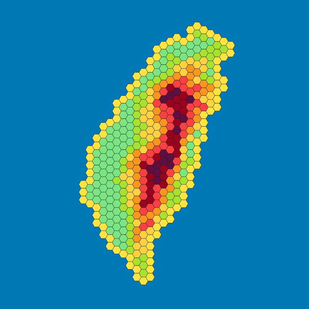
This map shows the population density of #Taiwan based on census data from December 2023. The highest population density with more than 30,000 people per square kilometer is in Yonghe District in the Taipei metropolitan area.
#taiwanmap #mappingtaiwan #populationdensity #maps #dataviz #demographic
#taiwanmap #mappingtaiwan #populationdensity #maps #dataviz #demographic

April 8, 2025 at 12:18 AM
This map shows the population density of #Taiwan based on census data from December 2023. The highest population density with more than 30,000 people per square kilometer is in Yonghe District in the Taipei metropolitan area.
#taiwanmap #mappingtaiwan #populationdensity #maps #dataviz #demographic
#taiwanmap #mappingtaiwan #populationdensity #maps #dataviz #demographic
In case you were wondering- and we know you were
Here is a world map of where the next 1000 babies will be born
#birthrate #worldmap #maps #map #babies #birth #birthing #population #countries #populationdensity #americas #europe #africa #asia #datanerd #dataviz #datavisual
Here is a world map of where the next 1000 babies will be born
#birthrate #worldmap #maps #map #babies #birth #birthing #population #countries #populationdensity #americas #europe #africa #asia #datanerd #dataviz #datavisual

December 4, 2024 at 7:24 PM
In case you were wondering- and we know you were
Here is a world map of where the next 1000 babies will be born
#birthrate #worldmap #maps #map #babies #birth #birthing #population #countries #populationdensity #americas #europe #africa #asia #datanerd #dataviz #datavisual
Here is a world map of where the next 1000 babies will be born
#birthrate #worldmap #maps #map #babies #birth #birthing #population #countries #populationdensity #americas #europe #africa #asia #datanerd #dataviz #datavisual

#land #housing #PopulationDensity
'The Lincoln Institute of Land Policy launched an updated iteration of Visualizing Density, a database containing hundreds of aerial photographs of neighborhoods each measured by housing density in units per acre. '
www.lincolninst.edu/publications...
'The Lincoln Institute of Land Policy launched an updated iteration of Visualizing Density, a database containing hundreds of aerial photographs of neighborhoods each measured by housing density in units per acre. '
www.lincolninst.edu/publications...

Lincoln Institute Unveils Updated Visualizing Density Database - Lincoln Institute of Land Policy
Featuring more than 100 images of residential density, this online database helps communities make informed and equitable development decisions that affect housing affordability.
www.lincolninst.edu
September 18, 2025 at 2:57 AM
#land #housing #PopulationDensity
'The Lincoln Institute of Land Policy launched an updated iteration of Visualizing Density, a database containing hundreds of aerial photographs of neighborhoods each measured by housing density in units per acre. '
www.lincolninst.edu/publications...
'The Lincoln Institute of Land Policy launched an updated iteration of Visualizing Density, a database containing hundreds of aerial photographs of neighborhoods each measured by housing density in units per acre. '
www.lincolninst.edu/publications...
50/50 🇰🇿
🔴 Red = areas where 51% of Kazakhstan’s population lives
⚪ Gray = the remaining 49%
Map highlights urban centers vs. vast sparsely populated land
#Kazakhstan #Demography #Population #DataViz #PopulationDensity #Regions #Map #Statistics #Python #Visualization
🔴 Red = areas where 51% of Kazakhstan’s population lives
⚪ Gray = the remaining 49%
Map highlights urban centers vs. vast sparsely populated land
#Kazakhstan #Demography #Population #DataViz #PopulationDensity #Regions #Map #Statistics #Python #Visualization

July 27, 2025 at 9:27 PM
50/50 🇰🇿
🔴 Red = areas where 51% of Kazakhstan’s population lives
⚪ Gray = the remaining 49%
Map highlights urban centers vs. vast sparsely populated land
#Kazakhstan #Demography #Population #DataViz #PopulationDensity #Regions #Map #Statistics #Python #Visualization
🔴 Red = areas where 51% of Kazakhstan’s population lives
⚪ Gray = the remaining 49%
Map highlights urban centers vs. vast sparsely populated land
#Kazakhstan #Demography #Population #DataViz #PopulationDensity #Regions #Map #Statistics #Python #Visualization

Why High Population Density is a Problem and How You Can Help!
youtube.com/shorts/Bnir1...
#childfree #childfreebychoice #population #populationdensity
youtube.com/shorts/Bnir1...
#childfree #childfreebychoice #population #populationdensity

Why High Population Density is a Problem and How You Can Help
YouTube video by The Childfree Couple
youtube.com
January 14, 2025 at 9:20 AM
Why High Population Density is a Problem and How You Can Help!
youtube.com/shorts/Bnir1...
#childfree #childfreebychoice #population #populationdensity
youtube.com/shorts/Bnir1...
#childfree #childfreebychoice #population #populationdensity

#FunFacts About #Canada 🇨🇦
Canada’s population is approximately 41.5 million people. Of those, 2/3 live within 150 miles of the US border.
#population #PopulationDensity #border
Canada’s population is approximately 41.5 million people. Of those, 2/3 live within 150 miles of the US border.
#population #PopulationDensity #border

May 21, 2025 at 1:39 AM
#FunFacts About #Canada 🇨🇦
Canada’s population is approximately 41.5 million people. Of those, 2/3 live within 150 miles of the US border.
#population #PopulationDensity #border
Canada’s population is approximately 41.5 million people. Of those, 2/3 live within 150 miles of the US border.
#population #PopulationDensity #border

Love a good population density map! Taking a tour of the world starting at home. We live in the black void above America. #populationdensity #maps #northamerica #USA #Mexico #Canada? #mapporn

March 7, 2024 at 2:08 AM
Love a good population density map! Taking a tour of the world starting at home. We live in the black void above America. #populationdensity #maps #northamerica #USA #Mexico #Canada? #mapporn
Population density by district in Kazakhstan 🇰🇿
Highest: urban centers like Almaty & Astana
Lowest: remote western and central areas
Country avg: 7.37 people/km²
#Kazakhstan #PopulationDensity #DataViz #Geography #RProgramming #Visualization #GeoMaps #DataAnalysis
Highest: urban centers like Almaty & Astana
Lowest: remote western and central areas
Country avg: 7.37 people/km²
#Kazakhstan #PopulationDensity #DataViz #Geography #RProgramming #Visualization #GeoMaps #DataAnalysis

July 27, 2025 at 8:52 PM
Population density by district in Kazakhstan 🇰🇿
Highest: urban centers like Almaty & Astana
Lowest: remote western and central areas
Country avg: 7.37 people/km²
#Kazakhstan #PopulationDensity #DataViz #Geography #RProgramming #Visualization #GeoMaps #DataAnalysis
Highest: urban centers like Almaty & Astana
Lowest: remote western and central areas
Country avg: 7.37 people/km²
#Kazakhstan #PopulationDensity #DataViz #Geography #RProgramming #Visualization #GeoMaps #DataAnalysis

sooooo how much of Russia is populated? it looks massive on a map but how much of that is snowy mountains and farmland?
#question #russia #populationdensity
#question #russia #populationdensity
April 6, 2025 at 5:33 AM
sooooo how much of Russia is populated? it looks massive on a map but how much of that is snowy mountains and farmland?
#question #russia #populationdensity
#question #russia #populationdensity
In case you were wondering- and we know you were
Here is a map of Manhattan that shows population density by block.
The highest blocks are upwards of 5000+ people!
#manhatten #newyork #maps #map #popdensity #populationdensity #population #residential #worldpopulation #datanerd #data #dataviz
Here is a map of Manhattan that shows population density by block.
The highest blocks are upwards of 5000+ people!
#manhatten #newyork #maps #map #popdensity #populationdensity #population #residential #worldpopulation #datanerd #data #dataviz

December 4, 2024 at 5:19 PM
In case you were wondering- and we know you were
Here is a map of Manhattan that shows population density by block.
The highest blocks are upwards of 5000+ people!
#manhatten #newyork #maps #map #popdensity #populationdensity #population #residential #worldpopulation #datanerd #data #dataviz
Here is a map of Manhattan that shows population density by block.
The highest blocks are upwards of 5000+ people!
#manhatten #newyork #maps #map #popdensity #populationdensity #population #residential #worldpopulation #datanerd #data #dataviz
Kazakhstan’s population in 3D 🇰🇿
Each spike = where people actually live
Tallest: Almaty, Astana, Shymkent 🏙️
Flat = vast uninhabited steppes & deserts
Built in #R with #rayshader
#Kazakhstan #PopulationDensity #3DMap #DataViz #GIS #SpatialData #CentralAsia #Mapping #Demographics
Each spike = where people actually live
Tallest: Almaty, Astana, Shymkent 🏙️
Flat = vast uninhabited steppes & deserts
Built in #R with #rayshader
#Kazakhstan #PopulationDensity #3DMap #DataViz #GIS #SpatialData #CentralAsia #Mapping #Demographics

July 27, 2025 at 9:52 PM
Kazakhstan’s population in 3D 🇰🇿
Each spike = where people actually live
Tallest: Almaty, Astana, Shymkent 🏙️
Flat = vast uninhabited steppes & deserts
Built in #R with #rayshader
#Kazakhstan #PopulationDensity #3DMap #DataViz #GIS #SpatialData #CentralAsia #Mapping #Demographics
Each spike = where people actually live
Tallest: Almaty, Astana, Shymkent 🏙️
Flat = vast uninhabited steppes & deserts
Built in #R with #rayshader
#Kazakhstan #PopulationDensity #3DMap #DataViz #GIS #SpatialData #CentralAsia #Mapping #Demographics

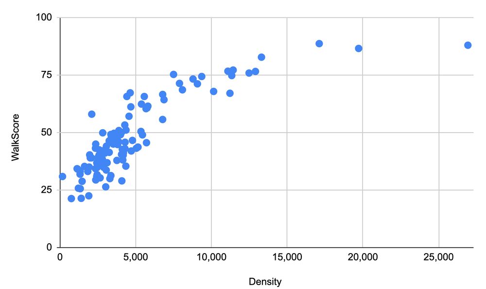
Graphed #populationdensity against: #walkscore; BikeScore; TransitScore.


September 22, 2025 at 2:15 AM
Graphed #populationdensity against: #walkscore; BikeScore; TransitScore.

Multidimensional plasticity of phenology: assessing the effects of population density on plastic responses of breeding time to temperature
https://doi.org/10.1111/oik.10959
#MultidimensionalPlasticity #BreedingPhenology #TerritorySize #PopulationDensity
https://doi.org/10.1111/oik.10959
#MultidimensionalPlasticity #BreedingPhenology #TerritorySize #PopulationDensity

February 28, 2025 at 5:06 PM
Multidimensional plasticity of phenology: assessing the effects of population density on plastic responses of breeding time to temperature
https://doi.org/10.1111/oik.10959
#MultidimensionalPlasticity #BreedingPhenology #TerritorySize #PopulationDensity
https://doi.org/10.1111/oik.10959
#MultidimensionalPlasticity #BreedingPhenology #TerritorySize #PopulationDensity

This graph is a tribute to Otto Neurath, showcasing population density across countries through blocks and person icons illustrate density levels. #OttoNeurath #DataViz #DataVisualization #PopulationDensity #Infographics #VisualEducation #Demographics
playground.graphane.dev/editor/gmsgr...
playground.graphane.dev/editor/gmsgr...

Population density | Graphane Playground
playground.graphane.dev
December 2, 2024 at 6:40 AM
This graph is a tribute to Otto Neurath, showcasing population density across countries through blocks and person icons illustrate density levels. #OttoNeurath #DataViz #DataVisualization #PopulationDensity #Infographics #VisualEducation #Demographics
playground.graphane.dev/editor/gmsgr...
playground.graphane.dev/editor/gmsgr...


Astronomy Picture from 05/03/2003
Where People Live on Planet Earth
Source: https://apod.nasa.gov/apod/ap030305.htm<a href="/hashtag/WorldPopulation" class="hover:underline text-blue-600 dark:text-sky-400 no-card-link">#WorldPopulationp#PopulationDensityn#GeographicDistributionr#HumanGeographye#EarthScienceh#1994Data1#Asiat#SparselyPopulatedo#Mapted #Map

June 23, 2025 at 2:16 PM
Astronomy Picture from 05/03/2003
Where People Live on Planet Earth
Source: https://apod.nasa.gov/apod/ap030305.htm<a href="/hashtag/WorldPopulation" class="hover:underline text-blue-600 dark:text-sky-400 no-card-link">#WorldPopulationp#PopulationDensityn#GeographicDistributionr#HumanGeographye#EarthScienceh#1994Data1#Asiat#SparselyPopulatedo#Mapted #Map
Where People Live on Planet Earth
Source: https://apod.nasa.gov/apod/ap030305.htm<a href="/hashtag/WorldPopulation" class="hover:underline text-blue-600 dark:text-sky-400 no-card-link">#WorldPopulationp#PopulationDensityn#GeographicDistributionr#HumanGeographye#EarthScienceh#1994Data1#Asiat#SparselyPopulatedo#Mapted #Map

Corn doesn’t #vote mother
fucker!
Sooooo fucking stupid.
#NoKings
#Resist
#PopulationDensity
#LandDoesntVote
#TreesDontVote
fucker!
Sooooo fucking stupid.
#NoKings
#Resist
#PopulationDensity
#LandDoesntVote
#TreesDontVote

June 14, 2025 at 9:43 PM
Corn doesn’t #vote mother
fucker!
Sooooo fucking stupid.
#NoKings
#Resist
#PopulationDensity
#LandDoesntVote
#TreesDontVote
fucker!
Sooooo fucking stupid.
#NoKings
#Resist
#PopulationDensity
#LandDoesntVote
#TreesDontVote
🌊 Population density along the Caspian Sea coast
Within 25 km: 9.38M people 🧜♂️
Top share: 🇦🇿 38%, 🇮🇷 24%, 🇰🇿 21%
Longest coastline: 🇰🇿 39% (2320 km)
Map shows 3D spikes by density
#CaspianSea #PopulationDensity #Kazakhstan #Azerbaijan #Iran #Russia #Turkmenistan #Geography #DataViz #3DMap
Within 25 km: 9.38M people 🧜♂️
Top share: 🇦🇿 38%, 🇮🇷 24%, 🇰🇿 21%
Longest coastline: 🇰🇿 39% (2320 km)
Map shows 3D spikes by density
#CaspianSea #PopulationDensity #Kazakhstan #Azerbaijan #Iran #Russia #Turkmenistan #Geography #DataViz #3DMap

July 27, 2025 at 9:51 PM
🌊 Population density along the Caspian Sea coast
Within 25 km: 9.38M people 🧜♂️
Top share: 🇦🇿 38%, 🇮🇷 24%, 🇰🇿 21%
Longest coastline: 🇰🇿 39% (2320 km)
Map shows 3D spikes by density
#CaspianSea #PopulationDensity #Kazakhstan #Azerbaijan #Iran #Russia #Turkmenistan #Geography #DataViz #3DMap
Within 25 km: 9.38M people 🧜♂️
Top share: 🇦🇿 38%, 🇮🇷 24%, 🇰🇿 21%
Longest coastline: 🇰🇿 39% (2320 km)
Map shows 3D spikes by density
#CaspianSea #PopulationDensity #Kazakhstan #Azerbaijan #Iran #Russia #Turkmenistan #Geography #DataViz #3DMap

Dhaka's Overcrowded Trains: A Crisis on Rails
#UrbanCrisis #DhakaTransport #PopulationDensity #SafetyFirst #GlobalNews #UrbanPlanning #trendingvideo #LatestNews #latestupdates #news #shorts #Reels #WATCH #Breaking #BreakingNews
#UrbanCrisis #DhakaTransport #PopulationDensity #SafetyFirst #GlobalNews #UrbanPlanning #trendingvideo #LatestNews #latestupdates #news #shorts #Reels #WATCH #Breaking #BreakingNews
July 22, 2025 at 12:31 PM
Dhaka's Overcrowded Trains: A Crisis on Rails
#UrbanCrisis #DhakaTransport #PopulationDensity #SafetyFirst #GlobalNews #UrbanPlanning #trendingvideo #LatestNews #latestupdates #news #shorts #Reels #WATCH #Breaking #BreakingNews
#UrbanCrisis #DhakaTransport #PopulationDensity #SafetyFirst #GlobalNews #UrbanPlanning #trendingvideo #LatestNews #latestupdates #news #shorts #Reels #WATCH #Breaking #BreakingNews


After 2 weeks in Japan, Seattle seems eerily empty of people #populationdensity
January 26, 2025 at 10:35 PM
After 2 weeks in Japan, Seattle seems eerily empty of people #populationdensity

On #PopulationDensity leading to #slums in #Mumbai due to bad #BuildingLaws:
“The Ruin Of Mumbai”, Asterisk (asteriskmag.com/issues/05/th...).
Via HN: news.ycombinator.com/item?id=3963...
#FAR #UrbanPlanning #India #FloorAreaRatio #Policies #Cities #RentControl #Bombay #Dharavi
“The Ruin Of Mumbai”, Asterisk (asteriskmag.com/issues/05/th...).
Via HN: news.ycombinator.com/item?id=3963...
#FAR #UrbanPlanning #India #FloorAreaRatio #Policies #Cities #RentControl #Bombay #Dharavi

The Ruin of Mumbai—Asterisk
Mumbai’s land use regulations are designed to keep population density low. Instead, they force Mumbaikars into slums, while all of India pays the price.
asteriskmag.com
March 9, 2024 at 5:17 AM
On #PopulationDensity leading to #slums in #Mumbai due to bad #BuildingLaws:
“The Ruin Of Mumbai”, Asterisk (asteriskmag.com/issues/05/th...).
Via HN: news.ycombinator.com/item?id=3963...
#FAR #UrbanPlanning #India #FloorAreaRatio #Policies #Cities #RentControl #Bombay #Dharavi
“The Ruin Of Mumbai”, Asterisk (asteriskmag.com/issues/05/th...).
Via HN: news.ycombinator.com/item?id=3963...
#FAR #UrbanPlanning #India #FloorAreaRatio #Policies #Cities #RentControl #Bombay #Dharavi
Population density of Kazakhstan 🇰🇿
1 dot = 10,000 people 🤵
Dot map shows where people are concentrated across the country
#Kazakhstan #PopulationDensity #DataViz #Geography #RProgramming #Analysis #GeoMaps #Visualization #DataScience
1 dot = 10,000 people 🤵
Dot map shows where people are concentrated across the country
#Kazakhstan #PopulationDensity #DataViz #Geography #RProgramming #Analysis #GeoMaps #Visualization #DataScience

July 27, 2025 at 9:08 PM
Population density of Kazakhstan 🇰🇿
1 dot = 10,000 people 🤵
Dot map shows where people are concentrated across the country
#Kazakhstan #PopulationDensity #DataViz #Geography #RProgramming #Analysis #GeoMaps #Visualization #DataScience
1 dot = 10,000 people 🤵
Dot map shows where people are concentrated across the country
#Kazakhstan #PopulationDensity #DataViz #Geography #RProgramming #Analysis #GeoMaps #Visualization #DataScience