


📣 Would you like a role where your work makes a real impact on local communities and supports growth across Breckland?
💡 We're looking for a Planning Policy Monitoring Officer to join our Planning Policy Team.
👉 Apply at https://loom.ly/4SOuitU.
🗓️ Closes 9am Monday, 18 August 2025.
💡 We're looking for a Planning Policy Monitoring Officer to join our Planning Policy Team.
👉 Apply at https://loom.ly/4SOuitU.
🗓️ Closes 9am Monday, 18 August 2025.


August 15, 2025 at 2:05 PM
📣 Would you like a role where your work makes a real impact on local communities and supports growth across Breckland?
💡 We're looking for a Planning Policy Monitoring Officer to join our Planning Policy Team.
👉 Apply at https://loom.ly/4SOuitU.
🗓️ Closes 9am Monday, 18 August 2025.
💡 We're looking for a Planning Policy Monitoring Officer to join our Planning Policy Team.
👉 Apply at https://loom.ly/4SOuitU.
🗓️ Closes 9am Monday, 18 August 2025.

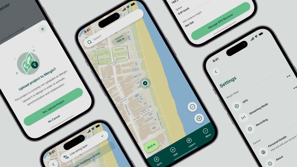
You wish we listen!
Layers list can now follow #QGIS order!
You can now order layers based on the QGIS layer tree order. This is enabled by default for new projects. For existing projects, you can turn it on in the project settings in QGIS.
#QGIS #MerginMaps #OpenSource #FieldDataCollection #GIS
Layers list can now follow #QGIS order!
You can now order layers based on the QGIS layer tree order. This is enabled by default for new projects. For existing projects, you can turn it on in the project settings in QGIS.
#QGIS #MerginMaps #OpenSource #FieldDataCollection #GIS
August 20, 2025 at 10:16 AM
You wish we listen!
Layers list can now follow #QGIS order!
You can now order layers based on the QGIS layer tree order. This is enabled by default for new projects. For existing projects, you can turn it on in the project settings in QGIS.
#QGIS #MerginMaps #OpenSource #FieldDataCollection #GIS
Layers list can now follow #QGIS order!
You can now order layers based on the QGIS layer tree order. This is enabled by default for new projects. For existing projects, you can turn it on in the project settings in QGIS.
#QGIS #MerginMaps #OpenSource #FieldDataCollection #GIS

Switching to gpt-5-mini-2025-08-07 and this is working much better. So Claude was correct that the models were the issue here.

October 16, 2025 at 3:29 PM
Switching to gpt-5-mini-2025-08-07 and this is working much better. So Claude was correct that the models were the issue here.

LOL, and the whole premise ignores WFS and WMS that has totally enabled cross collaboration with GIS data
September 13, 2023 at 9:42 AM
LOL, and the whole premise ignores WFS and WMS that has totally enabled cross collaboration with GIS data

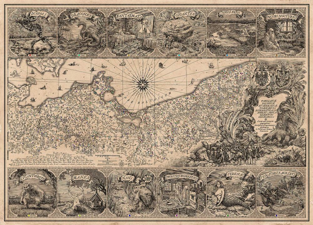
A Renaissance-inspired, GIS-enabled, ethnographic map based on regional folk tales of supernatural beings along the Polish-German borderland.
Master class for any aspiring fantasy worldbuilder. 🧪
www.tandfonline.com/doi/full/10....
Master class for any aspiring fantasy worldbuilder. 🧪
www.tandfonline.com/doi/full/10....
January 4, 2025 at 9:29 AM
A Renaissance-inspired, GIS-enabled, ethnographic map based on regional folk tales of supernatural beings along the Polish-German borderland.
Master class for any aspiring fantasy worldbuilder. 🧪
www.tandfonline.com/doi/full/10....
Master class for any aspiring fantasy worldbuilder. 🧪
www.tandfonline.com/doi/full/10....

Possibly worth noting also that the city got new streetlights installed last summer in anticipation of this project. So we can have some confidence that the crosswalks will be well-lit! #a2council


February 20, 2025 at 4:49 PM
Possibly worth noting also that the city got new streetlights installed last summer in anticipation of this project. So we can have some confidence that the crosswalks will be well-lit! #a2council

For example we run 'geoslurp', a @postgis enabled @PostgreSQL database to ingest and query the irregular Argo data (https://wobbly.earth/geoslurp/). Really, this makes life so much easier, I've been living under a rock and failed to see established GIS tech solves a lot of your...

November 7, 2024 at 4:12 PM
For example we run 'geoslurp', a @postgis enabled @PostgreSQL database to ingest and query the irregular Argo data (https://wobbly.earth/geoslurp/). Really, this makes life so much easier, I've been living under a rock and failed to see established GIS tech solves a lot of your...

Agree with the gist of the article, however a lot of “AI” haters are woefully ignorant of the advances in scientific research enabled by modern ML techniques. Fields like pharma, astronomy, GIS and many more are benefiting from the AI craze. To fully discount it as a dumb fad is just idiotic.
March 29, 2025 at 7:36 PM
Agree with the gist of the article, however a lot of “AI” haters are woefully ignorant of the advances in scientific research enabled by modern ML techniques. Fields like pharma, astronomy, GIS and many more are benefiting from the AI craze. To fully discount it as a dumb fad is just idiotic.

Creating the Policy and Legal Framework for a Location-enabled Society at Harvard will be live-streamed <a href="http://bit.ly/lPdrvw" class="hover:underline text-blue-600 dark:text-sky-400 no-card-link" target="_blank" rel="noopener" data-link="bsky">http://bit.ly/lPdrvw #gis
Projects at Harvard
bit.ly
November 10, 2024 at 2:08 PM
Creating the Policy and Legal Framework for a Location-enabled Society at Harvard will be live-streamed <a href="http://bit.ly/lPdrvw" class="hover:underline text-blue-600 dark:text-sky-400 no-card-link" target="_blank" rel="noopener" data-link="bsky">http://bit.ly/lPdrvw #gis

The developers of @postgresql.bsky.social and @postgis.bsky.social. Having a spatially enabled RDBMS allowed me to build the GIS in IB within the budget constraints we had at the time. #qgis and other #foss4g packages have allowed me to continue and build out. #gischat
November 20, 2024 at 6:40 PM
The developers of @postgresql.bsky.social and @postgis.bsky.social. Having a spatially enabled RDBMS allowed me to build the GIS in IB within the budget constraints we had at the time. #qgis and other #foss4g packages have allowed me to continue and build out. #gischat

Digitally-Enabled Research on Remote Rural Areas: Are We Losing More Than We Gain?
The paper "Digitally-Enabled Uplands Research" critiques the reliance on digital technologies in studying remote rural regions. While advancements like GIS and AI enhance research efficiency, they often overlook…
The paper "Digitally-Enabled Uplands Research" critiques the reliance on digital technologies in studying remote rural regions. While advancements like GIS and AI enhance research efficiency, they often overlook…

Digitally-Enabled Research on Remote Rural Areas: Are We Losing More Than We Gain?
The paper "Digitally-Enabled Uplands Research" critiques the reliance on digital technologies in studying remote rural regions. While advancements like GIS and AI enhance research efficiency, they often overlook social and cultural dimensions, emphasising technical solutions. This post advocates for more inclusive research practices that engage local communities and reflect the complexities of upland life.
ict4dblog.wordpress.com
March 25, 2025 at 8:08 AM
Digitally-Enabled Research on Remote Rural Areas: Are We Losing More Than We Gain?
The paper "Digitally-Enabled Uplands Research" critiques the reliance on digital technologies in studying remote rural regions. While advancements like GIS and AI enhance research efficiency, they often overlook…
The paper "Digitally-Enabled Uplands Research" critiques the reliance on digital technologies in studying remote rural regions. While advancements like GIS and AI enhance research efficiency, they often overlook…
📣 Would you like a role where your work makes a real impact on local communities and supports growth across Breckland?
💡 We're looking for a Planning Policy Monitoring Officer to join our Planning Policy Team.
👉 Apply at https://loom.ly/4SOuitU.
🗓️ Closes 9am Monday, 18 August 2025.
💡 We're looking for a Planning Policy Monitoring Officer to join our Planning Policy Team.
👉 Apply at https://loom.ly/4SOuitU.
🗓️ Closes 9am Monday, 18 August 2025.
August 10, 2025 at 9:00 AM
📣 Would you like a role where your work makes a real impact on local communities and supports growth across Breckland?
💡 We're looking for a Planning Policy Monitoring Officer to join our Planning Policy Team.
👉 Apply at https://loom.ly/4SOuitU.
🗓️ Closes 9am Monday, 18 August 2025.
💡 We're looking for a Planning Policy Monitoring Officer to join our Planning Policy Team.
👉 Apply at https://loom.ly/4SOuitU.
🗓️ Closes 9am Monday, 18 August 2025.
Open Call for Applications, Advancing the Spatially Enabled Smart Campus, Santa Barbara, CA, 11-12 Dec <a href="http://bit.ly/196aLVs" class="hover:underline text-blue-600 dark:text-sky-400 no-card-link" target="_blank" rel="noopener" data-link="bsky">http://bit.ly/196aLVs #gis
Error
bit.ly
November 10, 2024 at 12:06 PM
Open Call for Applications, Advancing the Spatially Enabled Smart Campus, Santa Barbara, CA, 11-12 Dec <a href="http://bit.ly/196aLVs" class="hover:underline text-blue-600 dark:text-sky-400 no-card-link" target="_blank" rel="noopener" data-link="bsky">http://bit.ly/196aLVs #gis
yea this getting somewhere now


October 16, 2025 at 3:29 PM
yea this getting somewhere now

Day 14 of my AI-Powered Mapping video series features a voice-enabled nearby places app powered by Esri's Places Service and ElevenLabs. 🗣 📍
📽 Watch now: youtu.be/SzsVdNtfAjM
#ArcGIS #GIS #AI #ElevenLabs
📽 Watch now: youtu.be/SzsVdNtfAjM
#ArcGIS #GIS #AI #ElevenLabs

Voice-Enable a Nearby Places App with ElevenLabs
YouTube video by Courtney Yatteau
youtu.be
December 15, 2024 at 6:48 PM
Day 14 of my AI-Powered Mapping video series features a voice-enabled nearby places app powered by Esri's Places Service and ElevenLabs. 🗣 📍
📽 Watch now: youtu.be/SzsVdNtfAjM
#ArcGIS #GIS #AI #ElevenLabs
📽 Watch now: youtu.be/SzsVdNtfAjM
#ArcGIS #GIS #AI #ElevenLabs
Did you know? The Esri Startup Zone at #FedGIS2025 was a hub of innovation 🚀, showcasing groundbreaking #GIS & location-enabled solutions from Esri and the startups that we work with to shape the future of geospatial! Learn more at ow.ly/OMyW50VnSkk
#geosky #GISchat
#geosky #GISchat

March 26, 2025 at 9:12 PM
Did you know? The Esri Startup Zone at #FedGIS2025 was a hub of innovation 🚀, showcasing groundbreaking #GIS & location-enabled solutions from Esri and the startups that we work with to shape the future of geospatial! Learn more at ow.ly/OMyW50VnSkk
#geosky #GISchat
#geosky #GISchat

On July 14th from 10 a.m.-2 p.m., you can try out and provide feedback on @MVCAuthority new GIS-enabled mobile app called EcoTrekr. The app acts as a living classroom as you walk down the paved path. For more information or to register please email [email protected]

March 10, 2025 at 5:51 AM
On July 14th from 10 a.m.-2 p.m., you can try out and provide feedback on @MVCAuthority new GIS-enabled mobile app called EcoTrekr. The app acts as a living classroom as you walk down the paved path. For more information or to register please email [email protected]

I’d love to see that congressional crossover attribute vs some metric of gerrymandering visualized. GIS technology (and judicial tolerance for
massive gerrymanders) has enabled parties to select voters rather than the inverse. Closed primaries further reinforce this divide.
massive gerrymanders) has enabled parties to select voters rather than the inverse. Closed primaries further reinforce this divide.
October 18, 2024 at 12:04 PM
I’d love to see that congressional crossover attribute vs some metric of gerrymandering visualized. GIS technology (and judicial tolerance for
massive gerrymanders) has enabled parties to select voters rather than the inverse. Closed primaries further reinforce this divide.
massive gerrymanders) has enabled parties to select voters rather than the inverse. Closed primaries further reinforce this divide.
Final report on Advancing the Spatially-Enabled Smart Campus workshop now online <a href="http://bit.ly/1o0uRsw" class="hover:underline text-blue-600 dark:text-sky-400 no-card-link" target="_blank" rel="noopener" data-link="bsky">http://bit.ly/1o0uRsw #gis
Error
bit.ly
November 10, 2024 at 1:23 AM
Final report on Advancing the Spatially-Enabled Smart Campus workshop now online <a href="http://bit.ly/1o0uRsw" class="hover:underline text-blue-600 dark:text-sky-400 no-card-link" target="_blank" rel="noopener" data-link="bsky">http://bit.ly/1o0uRsw #gis

Is there an easy way to download these results in spreadsheet form - or even already GIS enabled?
November 13, 2024 at 2:30 PM
Is there an easy way to download these results in spreadsheet form - or even already GIS enabled?
very cool, new 3D Dashboard, built w/Javascript 4.1 (browser must be WebGL-enabled) <a href="http://arcg.is/1Pg7Jlg" class="hover:underline text-blue-600 dark:text-sky-400 no-card-link" target="_blank" rel="noopener" data-link="bsky">http://arcg.is/1Pg7Jlg #GIS <a href="http://t.co/omKh7gLfuI" class="hover:underline text-blue-600 dark:text-sky-400 no-card-link" target="_blank" rel="noopener" data-link="bsky">http://t.co/omKh7gLfuI


November 9, 2024 at 4:49 PM
very cool, new 3D Dashboard, built w/Javascript 4.1 (browser must be WebGL-enabled) <a href="http://arcg.is/1Pg7Jlg" class="hover:underline text-blue-600 dark:text-sky-400 no-card-link" target="_blank" rel="noopener" data-link="bsky">http://arcg.is/1Pg7Jlg #GIS <a href="http://t.co/omKh7gLfuI" class="hover:underline text-blue-600 dark:text-sky-400 no-card-link" target="_blank" rel="noopener" data-link="bsky">http://t.co/omKh7gLfuI

Today’s release marks a huge shift in how teams are enabled with spatial decision-making tools. Big thanks to our investors at @Energize Capital, @Footwork and @baincapvc.bsky.social for believing in a better future for GIS.
July 15, 2025 at 3:39 PM
Today’s release marks a huge shift in how teams are enabled with spatial decision-making tools. Big thanks to our investors at @Energize Capital, @Footwork and @baincapvc.bsky.social for believing in a better future for GIS.
Friendly reminder: Web GIS is web *services* based. Think “dial tone” which is a great analogy that Jack uses, to help users understand the full power of “distributed” and “interconnected” and “enabled.” #GeodesignSummit


November 8, 2024 at 9:18 PM
Friendly reminder: Web GIS is web *services* based. Think “dial tone” which is a great analogy that Jack uses, to help users understand the full power of “distributed” and “interconnected” and “enabled.” #GeodesignSummit
GIS set to British National Grid, I was one of the people who struggled to get QGIS to do this, the requisite option not available, for some people it is, fortunately other tales of anguish on forums enabled me to eventually sort that out.
October 13, 2025 at 9:21 AM
GIS set to British National Grid, I was one of the people who struggled to get QGIS to do this, the requisite option not available, for some people it is, fortunately other tales of anguish on forums enabled me to eventually sort that out.

📖 🎙️ **Landscapes of Warfare
Urartu and Assyria in the Ancient Middle East by Tiffany Earley-Spadoni**
"_Using an interdisciplinary approach that includes GIS-enabled studies and integrates archaeological, historical, and art-historical evidence, she illustrates how warfare was a generative […]
Urartu and Assyria in the Ancient Middle East by Tiffany Earley-Spadoni**
"_Using an interdisciplinary approach that includes GIS-enabled studies and integrates archaeological, historical, and art-historical evidence, she illustrates how warfare was a generative […]
Original post on qoto.org
qoto.org
September 28, 2025 at 6:42 PM
📖 🎙️ **Landscapes of Warfare
Urartu and Assyria in the Ancient Middle East by Tiffany Earley-Spadoni**
"_Using an interdisciplinary approach that includes GIS-enabled studies and integrates archaeological, historical, and art-historical evidence, she illustrates how warfare was a generative […]
Urartu and Assyria in the Ancient Middle East by Tiffany Earley-Spadoni**
"_Using an interdisciplinary approach that includes GIS-enabled studies and integrates archaeological, historical, and art-historical evidence, she illustrates how warfare was a generative […]