


#cyclones #typhoons #jtwc ABPW10 PGTW 030600
MSGID/GENADMIN/JOINT TYPHOON WRNCEN PEARL HARBOR HI//
SUBJ/SIGNIFICANT TROPICAL WEATHER ADVISORY FOR THE WESTERN AND SOUTH
PACIFIC OCEANS/030600Z-040600ZNOV2025//
REF/A/MSG/JOINT TYPHOON WRNCEN PEARL HARBOR […]
[Original post on ai6yr.org]
MSGID/GENADMIN/JOINT TYPHOON WRNCEN PEARL HARBOR HI//
SUBJ/SIGNIFICANT TROPICAL WEATHER ADVISORY FOR THE WESTERN AND SOUTH
PACIFIC OCEANS/030600Z-040600ZNOV2025//
REF/A/MSG/JOINT TYPHOON WRNCEN PEARL HARBOR […]
[Original post on ai6yr.org]

November 3, 2025 at 6:03 AM
#cyclones #typhoons #jtwc ABPW10 PGTW 030600
MSGID/GENADMIN/JOINT TYPHOON WRNCEN PEARL HARBOR HI//
SUBJ/SIGNIFICANT TROPICAL WEATHER ADVISORY FOR THE WESTERN AND SOUTH
PACIFIC OCEANS/030600Z-040600ZNOV2025//
REF/A/MSG/JOINT TYPHOON WRNCEN PEARL HARBOR […]
[Original post on ai6yr.org]
MSGID/GENADMIN/JOINT TYPHOON WRNCEN PEARL HARBOR HI//
SUBJ/SIGNIFICANT TROPICAL WEATHER ADVISORY FOR THE WESTERN AND SOUTH
PACIFIC OCEANS/030600Z-040600ZNOV2025//
REF/A/MSG/JOINT TYPHOON WRNCEN PEARL HARBOR […]
[Original post on ai6yr.org]
GCOM-W1 AMSR2 Microwave images show more prominent moating at 89 Ghz then previous images from today. Also more prominent secondary pink ring at 37 Ghz. Tho part of the truth is that the primary eyewall looks perhaps more intense then ever, very intense pink.


October 27, 2025 at 8:47 PM
GCOM-W1 AMSR2 Microwave images show more prominent moating at 89 Ghz then previous images from today. Also more prominent secondary pink ring at 37 Ghz. Tho part of the truth is that the primary eyewall looks perhaps more intense then ever, very intense pink.

Due to unstable access to #SSMIS data, we are suspending today the distribution of our #SeaIce concentration interim climate data record based on it (OSI-430-a).
We advise all users to switch to our #AMSR2 based climate products.
for more info: osi-saf.eumetsat.int/community/li...
We advise all users to switch to our #AMSR2 based climate products.
for more info: osi-saf.eumetsat.int/community/li...

October 17, 2025 at 12:34 PM
Due to unstable access to #SSMIS data, we are suspending today the distribution of our #SeaIce concentration interim climate data record based on it (OSI-430-a).
We advise all users to switch to our #AMSR2 based climate products.
for more info: osi-saf.eumetsat.int/community/li...
We advise all users to switch to our #AMSR2 based climate products.
for more info: osi-saf.eumetsat.int/community/li...

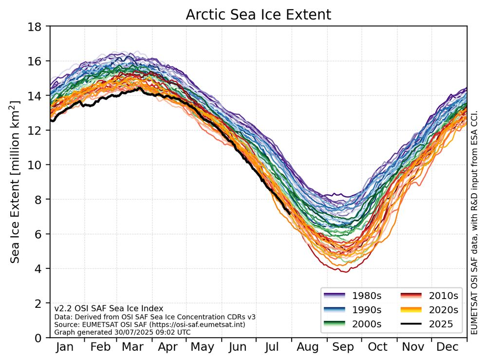
Here's a closer look at the record low sea ice conditions around #Svalbard. The ice edge is still close to the 85°N line of latitude along the Atlantic front. That's a lot of open water into the Barents Sea region! Data from AMSR2.

October 14, 2025 at 12:17 PM
Here's a closer look at the record low sea ice conditions around #Svalbard. The ice edge is still close to the 85°N line of latitude along the Atlantic front. That's a lot of open water into the Barents Sea region! Data from AMSR2.
Technical data update - Due to the U.S. government shutdown, some climate data visualizations on my website may not be updated as usual. I’ll refresh them as soon as possible. Sorry, and thanks for your patience!
Image from nsidc.org/data/g10016/...
Image from nsidc.org/data/g10016/...

October 3, 2025 at 9:06 PM
Technical data update - Due to the U.S. government shutdown, some climate data visualizations on my website may not be updated as usual. I’ll refresh them as soon as possible. Sorry, and thanks for your patience!
Image from nsidc.org/data/g10016/...
Image from nsidc.org/data/g10016/...

Mabel Heffring, Lincoln Linlin Xu
Bayesian Transformer for Pan-Arctic Sea Ice Concentration Mapping and Uncertainty Estimation using Sentinel-1, RCM, and AMSR2 Data
https://arxiv.org/abs/2509.25437
Bayesian Transformer for Pan-Arctic Sea Ice Concentration Mapping and Uncertainty Estimation using Sentinel-1, RCM, and AMSR2 Data
https://arxiv.org/abs/2509.25437
October 1, 2025 at 11:12 AM
Mabel Heffring, Lincoln Linlin Xu
Bayesian Transformer for Pan-Arctic Sea Ice Concentration Mapping and Uncertainty Estimation using Sentinel-1, RCM, and AMSR2 Data
https://arxiv.org/abs/2509.25437
Bayesian Transformer for Pan-Arctic Sea Ice Concentration Mapping and Uncertainty Estimation using Sentinel-1, RCM, and AMSR2 Data
https://arxiv.org/abs/2509.25437

Mabel Heffring, Lincoln Linlin Xu: Bayesian Transformer for Pan-Arctic Sea Ice Concentration Mapping and Uncertainty Estimation using Sentinel-1, RCM, and AMSR2 Data https://arxiv.org/abs/2509.25437 https://arxiv.org/pdf/2509.25437 https://arxiv.org/html/2509.25437
October 1, 2025 at 6:30 AM
Mabel Heffring, Lincoln Linlin Xu: Bayesian Transformer for Pan-Arctic Sea Ice Concentration Mapping and Uncertainty Estimation using Sentinel-1, RCM, and AMSR2 Data https://arxiv.org/abs/2509.25437 https://arxiv.org/pdf/2509.25437 https://arxiv.org/html/2509.25437
The AMSR2 instrument aboard JAXA's GCOM-W1 satellite captured these Microwave images of Super Typhoon Ragasa as it was rampaging through the Luzon strait. Babuyan, Calayan and Camiguin island being lashed by the ferocious eyewall of Nando at that time.


September 22, 2025 at 12:54 PM
The AMSR2 instrument aboard JAXA's GCOM-W1 satellite captured these Microwave images of Super Typhoon Ragasa as it was rampaging through the Luzon strait. Babuyan, Calayan and Camiguin island being lashed by the ferocious eyewall of Nando at that time.
AMSR2 GW1 microwave images from a few hours ago already showed a very healthy structure underneath the blossoming deep convection of Ragasa (NandoPH). Very well-defined banding was wrapping into a nascent inner core. Eyewall majority complete, open to the south-southwest.


September 19, 2025 at 8:31 PM
AMSR2 GW1 microwave images from a few hours ago already showed a very healthy structure underneath the blossoming deep convection of Ragasa (NandoPH). Very well-defined banding was wrapping into a nascent inner core. Eyewall majority complete, open to the south-southwest.

You should they're good!
Recommend any of them really - Zero Mission, AMSR2 (a top tier fan remake - honestly the dogs bollocks), Super, Fusion, or Dread - pretty good experience.
Don't recommend the OG NES game - it's very aged.
Recommend any of them really - Zero Mission, AMSR2 (a top tier fan remake - honestly the dogs bollocks), Super, Fusion, or Dread - pretty good experience.
Don't recommend the OG NES game - it's very aged.
September 10, 2025 at 5:18 PM
You should they're good!
Recommend any of them really - Zero Mission, AMSR2 (a top tier fan remake - honestly the dogs bollocks), Super, Fusion, or Dread - pretty good experience.
Don't recommend the OG NES game - it's very aged.
Recommend any of them really - Zero Mission, AMSR2 (a top tier fan remake - honestly the dogs bollocks), Super, Fusion, or Dread - pretty good experience.
Don't recommend the OG NES game - it's very aged.
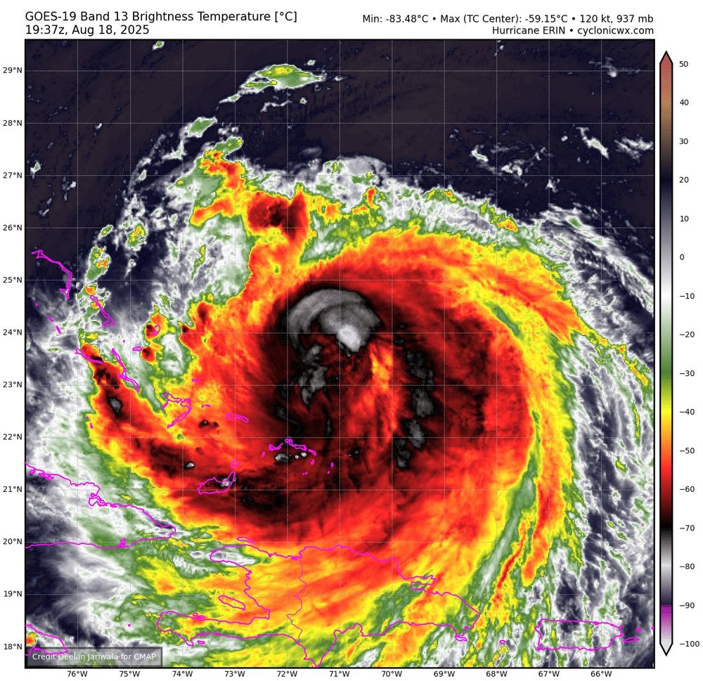
Very recent new AMSR2 GW1 microwave images hot off the press suggest that Erin now possesses a closed inner eyewall, this should help drop her MSLP even further. We won't get a new recon mission into Erin for a few hours to see this in action. #tropicswx


August 20, 2025 at 7:17 PM
Very recent new AMSR2 GW1 microwave images hot off the press suggest that Erin now possesses a closed inner eyewall, this should help drop her MSLP even further. We won't get a new recon mission into Erin for a few hours to see this in action. #tropicswx
Overnight images from the AMSR2 instrument aboard GCOM-W1 indicate that erin now features at least a quite a compact partial inner core, surrounded by a wide moat and concentric outer banding. Not the kind of banding likely to cause eyewall replacement tho, especially at this stage. #tropicswx


August 20, 2025 at 11:28 AM
Overnight images from the AMSR2 instrument aboard GCOM-W1 indicate that erin now features at least a quite a compact partial inner core, surrounded by a wide moat and concentric outer banding. Not the kind of banding likely to cause eyewall replacement tho, especially at this stage. #tropicswx
A AMSR2 GW1 89 Ghz microwave image from ~3 1/2 hrs ago indicates that the mid-level structure of Erin in particular had already gotten quite a bit better then this morning (UTC), with more well defined banding now present east of the LLCC but she got a lot of work still to do.


August 19, 2025 at 10:10 PM
A AMSR2 GW1 89 Ghz microwave image from ~3 1/2 hrs ago indicates that the mid-level structure of Erin in particular had already gotten quite a bit better then this morning (UTC), with more well defined banding now present east of the LLCC but she got a lot of work still to do.
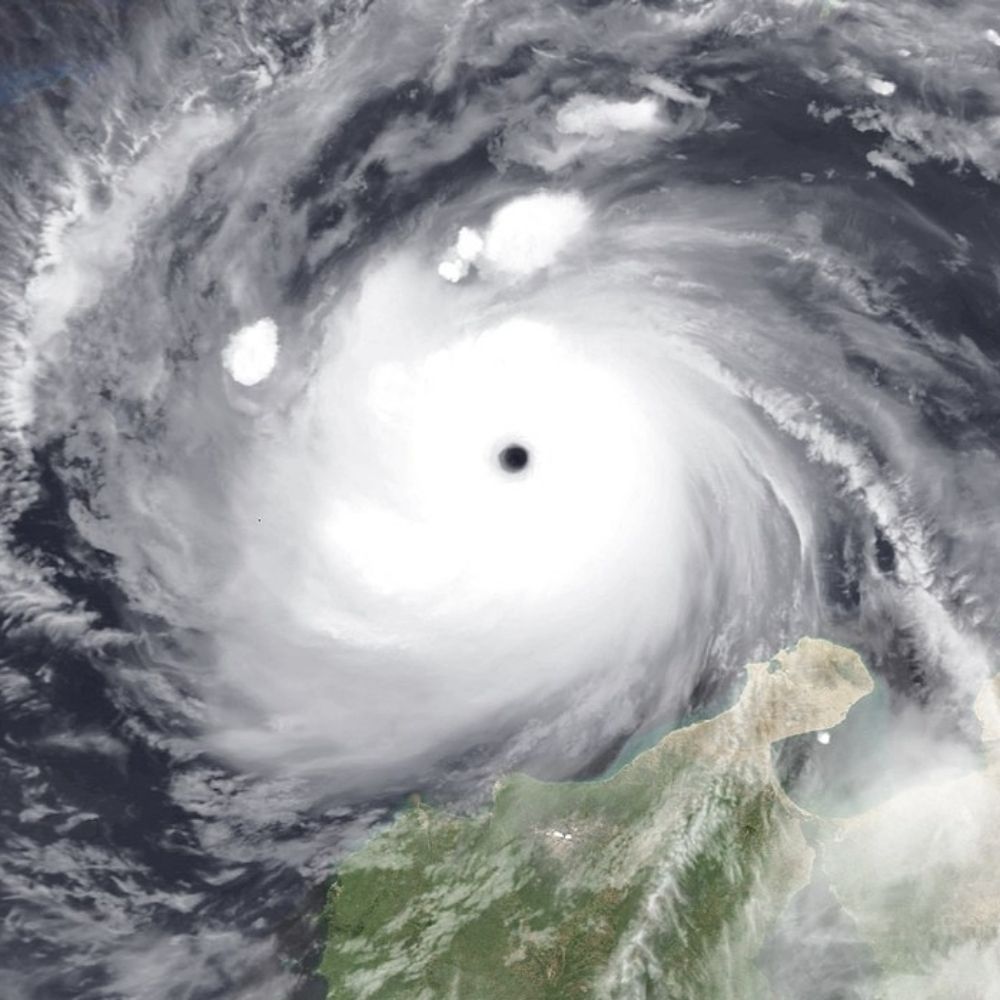
Erin is not looking too hot this evening. The eye has become cloud filled, the CDO increasingly misshapen. AMSR2 microwave images show an eyewall open to the west and extensive concentric banding on the other. None of these bands is capable of wrapping upshear, however. #tropicswx


August 18, 2025 at 7:51 PM
Erin is not looking too hot this evening. The eye has become cloud filled, the CDO increasingly misshapen. AMSR2 microwave images show an eyewall open to the west and extensive concentric banding on the other. None of these bands is capable of wrapping upshear, however. #tropicswx

The last "good" microwave pass was over 9 hours ago. So it is very difficult to tell subjectively or objectively if an ERC is really happening or not until it does.
Explanation of right image in alt text.
Explanation of right image in alt text.


August 17, 2025 at 3:38 PM
The last "good" microwave pass was over 9 hours ago. So it is very difficult to tell subjectively or objectively if an ERC is really happening or not until it does.
Explanation of right image in alt text.
Explanation of right image in alt text.
AMSR2 89 Ghz image from about 4 and a half hours ago, shows the vertical tilt of Erin quite well. The deep convection (in red), which correlates with the mid-level troughing/circulation is clearly offset to the southwest relative to the low-level cloud lines in cyan (color?).

August 14, 2025 at 9:14 PM
AMSR2 89 Ghz image from about 4 and a half hours ago, shows the vertical tilt of Erin quite well. The deep convection (in red), which correlates with the mid-level troughing/circulation is clearly offset to the southwest relative to the low-level cloud lines in cyan (color?).
Technical data update - This morning I went through and modified all of my real-time sea ice graphics to be consistent with the new NSIDC Sea Ice Index v4, which now uses AMSR2 for the year 2025.
The effect of this new product version update on my visualizations is expected to be minor.
The effect of this new product version update on my visualizations is expected to be minor.
August 2, 2025 at 3:16 PM
Technical data update - This morning I went through and modified all of my real-time sea ice graphics to be consistent with the new NSIDC Sea Ice Index v4, which now uses AMSR2 for the year 2025.
The effect of this new product version update on my visualizations is expected to be minor.
The effect of this new product version update on my visualizations is expected to be minor.

So it's come to this. As expected, on 1-Aug, Arctic ice data from US satellites is unavailable so NSIDC has switched to using data from the Japanese JAXA AMSR2 satellite. Which is now well beyond it's design
August 2, 2025 at 8:34 AM
So it's come to this. As expected, on 1-Aug, Arctic ice data from US satellites is unavailable so NSIDC has switched to using data from the Japanese JAXA AMSR2 satellite. Which is now well beyond it's design

So it's come to this. As expected, on 1-Aug, Arctic ice data from US satellites is unavailable so NSIDC has switched to using data from the Japanese JAXA AMSR2 satellite. Which is now well beyond it's design life […]
Original post on mastodon.social
mastodon.social
August 2, 2025 at 8:36 AM
So it's come to this. As expected, on 1-Aug, Arctic ice data from US satellites is unavailable so NSIDC has switched to using data from the Japanese JAXA AMSR2 satellite. Which is now well beyond it's design life […]
With the announcement that the U.S. SSMIS data will continue to be distributed after 31 July, the Sea-Ice Index will continue to be produced as usual, based on SSMIS-derived sea-ice concentration, but our plan remains to upgrade the index with data from on the alternative sensor AMSR2. Stay tuned!
August 1, 2025 at 1:27 PM
With the announcement that the U.S. SSMIS data will continue to be distributed after 31 July, the Sea-Ice Index will continue to be produced as usual, based on SSMIS-derived sea-ice concentration, but our plan remains to upgrade the index with data from on the alternative sensor AMSR2. Stay tuned!

For all the sea ice nerds, NSIDC has announced a new version of the sea ice index that replaces SSMIS data with AMSR2 (starting Jan 1, 2025 and continuing for all future updates).
This new dataset was developed in response to the plans to kill SSMIS.
nsidc.org/data/user-re...
This new dataset was developed in response to the plans to kill SSMIS.
nsidc.org/data/user-re...
New version release: NOAA/NSIDC Sea Ice Index, Version 4 | National Snow and Ice Data Center
NOAA@NSIDC is pleased to announce the release of Sea Ice Index, Version 4.
nsidc.org
August 1, 2025 at 11:14 AM
For all the sea ice nerds, NSIDC has announced a new version of the sea ice index that replaces SSMIS data with AMSR2 (starting Jan 1, 2025 and continuing for all future updates).
This new dataset was developed in response to the plans to kill SSMIS.
nsidc.org/data/user-re...
This new dataset was developed in response to the plans to kill SSMIS.
nsidc.org/data/user-re...
*Note: to accompany this data change (SSMIS to AMSR2), I will update all of my sea ice visualizations on my website this coming weekend to be consistent with this latest version.
August 1, 2025 at 1:07 AM
*Note: to accompany this data change (SSMIS to AMSR2), I will update all of my sea ice visualizations on my website this coming weekend to be consistent with this latest version.
Great news and well done @nsidc.bsky.social!
"NOAA@NSIDC is pleased to announce the release of Sea Ice Index, Version 4.
This new version uses input data from the JAXA GCOM-W1 AMSR2 instrument for 1 January 2025 through forward processing."
"NOAA@NSIDC is pleased to announce the release of Sea Ice Index, Version 4.
This new version uses input data from the JAXA GCOM-W1 AMSR2 instrument for 1 January 2025 through forward processing."
New version release: NOAA/NSIDC Sea Ice Index, Version 4 | National Snow and Ice Data Center
NOAA@NSIDC is pleased to announce the release of Sea Ice Index, Version 4.
nsidc.org
August 1, 2025 at 12:59 AM
Great news and well done @nsidc.bsky.social!
"NOAA@NSIDC is pleased to announce the release of Sea Ice Index, Version 4.
This new version uses input data from the JAXA GCOM-W1 AMSR2 instrument for 1 January 2025 through forward processing."
"NOAA@NSIDC is pleased to announce the release of Sea Ice Index, Version 4.
This new version uses input data from the JAXA GCOM-W1 AMSR2 instrument for 1 January 2025 through forward processing."
#SSMIS data-end grows close. Our #SeaIce team has been busy this summer to ensure product continuity.
Our Sea Ice Index will be updated from v2.2 (SSMIS based) to v2.3 ( #AMSR2 based) from Friday 01/08/2025 on.
more on: osi-saf.eumetsat.int/community/li...
#climate #arctic #antarctic
Our Sea Ice Index will be updated from v2.2 (SSMIS based) to v2.3 ( #AMSR2 based) from Friday 01/08/2025 on.
more on: osi-saf.eumetsat.int/community/li...
#climate #arctic #antarctic
July 30, 2025 at 1:08 PM
#SSMIS data-end grows close. Our #SeaIce team has been busy this summer to ensure product continuity.
Our Sea Ice Index will be updated from v2.2 (SSMIS based) to v2.3 ( #AMSR2 based) from Friday 01/08/2025 on.
more on: osi-saf.eumetsat.int/community/li...
#climate #arctic #antarctic
Our Sea Ice Index will be updated from v2.2 (SSMIS based) to v2.3 ( #AMSR2 based) from Friday 01/08/2025 on.
more on: osi-saf.eumetsat.int/community/li...
#climate #arctic #antarctic