


TR Baker
@trbaker.bsky.social
💙🌎📻📸Teacher. Author. GIS education. EdTech. Former university research prof. Kansas Earth science teacher. GIS and XR. #EduSky
Teaching erosional concepts with MapMaker Some landforms are shaped over time through the geomorphic process of erosion. #GIS #earthscience #teachers #geography #educators
More: www.linkedin.com/pulse/teachi...
More: www.linkedin.com/pulse/teachi...
October 8, 2025 at 6:11 PM
Teaching erosional concepts with MapMaker Some landforms are shaped over time through the geomorphic process of erosion. #GIS #earthscience #teachers #geography #educators
More: www.linkedin.com/pulse/teachi...
More: www.linkedin.com/pulse/teachi...
The ArcGIS for Schools Bundle license period has been extended. Learn more: community.esri.com/t5/education... #GIS #geography #K12 #APHG #edtech

April 24, 2025 at 8:28 PM
The ArcGIS for Schools Bundle license period has been extended. Learn more: community.esri.com/t5/education... #GIS #geography #K12 #APHG #edtech
Love LEGO? ❤️ Here's a fun Map of Wisconsin made with LEGOS and designed in #ArcGIS Pro
(1 brick=10 sq mi). The terrain is represented at different levels in elevation, with lakes and cities displayed.
Full map: esri.social/eBrZ50UoJwC
🗺️ 𝐴𝑢𝑡ℎ𝑜𝑟: 𝐴𝑡𝑙𝑎𝑠 𝐺𝑢𝑜
(1 brick=10 sq mi). The terrain is represented at different levels in elevation, with lakes and cities displayed.
Full map: esri.social/eBrZ50UoJwC
🗺️ 𝐴𝑢𝑡ℎ𝑜𝑟: 𝐴𝑡𝑙𝑎𝑠 𝐺𝑢𝑜

January 21, 2025 at 9:33 PM
Love LEGO? ❤️ Here's a fun Map of Wisconsin made with LEGOS and designed in #ArcGIS Pro
(1 brick=10 sq mi). The terrain is represented at different levels in elevation, with lakes and cities displayed.
Full map: esri.social/eBrZ50UoJwC
🗺️ 𝐴𝑢𝑡ℎ𝑜𝑟: 𝐴𝑡𝑙𝑎𝑠 𝐺𝑢𝑜
(1 brick=10 sq mi). The terrain is represented at different levels in elevation, with lakes and cities displayed.
Full map: esri.social/eBrZ50UoJwC
🗺️ 𝐴𝑢𝑡ℎ𝑜𝑟: 𝐴𝑡𝑙𝑎𝑠 𝐺𝑢𝑜
Career and technical education instructors can help increase students’ job readiness by building their professional GIS skills 💼
Explore #CTE resources, certifications, and more 👉 ow.ly/q9ZZ50UI8ir
Explore #CTE resources, certifications, and more 👉 ow.ly/q9ZZ50UI8ir

January 21, 2025 at 9:30 PM
Career and technical education instructors can help increase students’ job readiness by building their professional GIS skills 💼
Explore #CTE resources, certifications, and more 👉 ow.ly/q9ZZ50UI8ir
Explore #CTE resources, certifications, and more 👉 ow.ly/q9ZZ50UI8ir
Start your Near Year off right by incorporating National Geographic MapMaker into your curriculum! #NatGeoMapMaker equips teachers & learners with carefully curated maps, data, + activities for many subjects and grade levels.
Get started: esri.social/pHht50UymCb
#MappyNewYear
Get started: esri.social/pHht50UymCb
#MappyNewYear

January 10, 2025 at 7:42 PM
Start your Near Year off right by incorporating National Geographic MapMaker into your curriculum! #NatGeoMapMaker equips teachers & learners with carefully curated maps, data, + activities for many subjects and grade levels.
Get started: esri.social/pHht50UymCb
#MappyNewYear
Get started: esri.social/pHht50UymCb
#MappyNewYear
Where Do Christmas Trees Grow in the US? More than 25 million #Christmas trees are harvested in the U.S. each year. www.maps.com/where-christ... #geography #climate #GIS #solstice #holidays

December 19, 2024 at 8:16 PM
Where Do Christmas Trees Grow in the US? More than 25 million #Christmas trees are harvested in the U.S. each year. www.maps.com/where-christ... #geography #climate #GIS #solstice #holidays
Maps are powerful. 🗺️ They can spark curiosity, entertain, provide insight, and even drive people to take action that unites our world.
🔸Explore a gallery of inspiring maps: esri.social/MALE50Uclr5
#GIS #academicsky #Esri
🔸Explore a gallery of inspiring maps: esri.social/MALE50Uclr5
#GIS #academicsky #Esri


December 18, 2024 at 10:09 PM
Maps are powerful. 🗺️ They can spark curiosity, entertain, provide insight, and even drive people to take action that unites our world.
🔸Explore a gallery of inspiring maps: esri.social/MALE50Uclr5
#GIS #academicsky #Esri
🔸Explore a gallery of inspiring maps: esri.social/MALE50Uclr5
#GIS #academicsky #Esri
Educators! 🌟 Use this to help secondary students explore #GIS: esri.social/eGpE50UqhUZ #teachers #edusky #geography
Students will:
🔹View & identify map features & patterns
🔹Use GIS tools to analyze a problem
🔹Create a GIS web app that tells a story
🔹Describe how GIS helps people do their work
Students will:
🔹View & identify map features & patterns
🔹Use GIS tools to analyze a problem
🔹Create a GIS web app that tells a story
🔹Describe how GIS helps people do their work

December 18, 2024 at 10:04 PM
Educators! 🌟 Use this to help secondary students explore #GIS: esri.social/eGpE50UqhUZ #teachers #edusky #geography
Students will:
🔹View & identify map features & patterns
🔹Use GIS tools to analyze a problem
🔹Create a GIS web app that tells a story
🔹Describe how GIS helps people do their work
Students will:
🔹View & identify map features & patterns
🔹Use GIS tools to analyze a problem
🔹Create a GIS web app that tells a story
🔹Describe how GIS helps people do their work
The Audubon society Bird Migration Explorer is your guide to the heroic journeys made by over 450 bird species, and the challenges they face along the way. 🐦
🔸Explore the map: explorer.audubon.org/home #GIS #geography #bio #science
🔸Explore the map: explorer.audubon.org/home #GIS #geography #bio #science

December 16, 2024 at 1:36 PM
The Audubon society Bird Migration Explorer is your guide to the heroic journeys made by over 450 bird species, and the challenges they face along the way. 🐦
🔸Explore the map: explorer.audubon.org/home #GIS #geography #bio #science
🔸Explore the map: explorer.audubon.org/home #GIS #geography #bio #science

📍 Mapped: #US Home Price-to-Income Ratio By State (June 2024) Thanks @josephkerski.bsky.social www.visualcapitalist.com/mapped-home-... 🗺️ So many things said and unsaid in one map. #geography #sschat #socialstudies #economics

December 6, 2024 at 6:16 PM
📍 Mapped: #US Home Price-to-Income Ratio By State (June 2024) Thanks @josephkerski.bsky.social www.visualcapitalist.com/mapped-home-... 🗺️ So many things said and unsaid in one map. #geography #sschat #socialstudies #economics
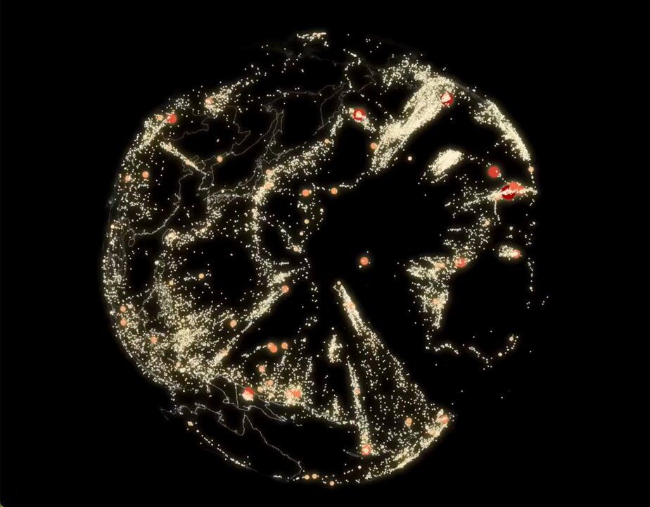
You're looking at earthquakes from inside the Earth. 🌏 Created by Raluca Nicola with the ArcGIS Maps SDK for JavaScript.
🔸Explore the app here: esri.social/BmH650UlkeR
#ArcGIS #JavaScript #geoscience #geography #edusky
🔸Explore the app here: esri.social/BmH650UlkeR
#ArcGIS #JavaScript #geoscience #geography #edusky
December 5, 2024 at 4:55 PM
You're looking at earthquakes from inside the Earth. 🌏 Created by Raluca Nicola with the ArcGIS Maps SDK for JavaScript.
🔸Explore the app here: esri.social/BmH650UlkeR
#ArcGIS #JavaScript #geoscience #geography #edusky
🔸Explore the app here: esri.social/BmH650UlkeR
#ArcGIS #JavaScript #geoscience #geography #edusky
I talked with a resourceful Earth science teacher today who is still using ArcView 3 on a Windows XP computer in his classroom! 🤯 Amazing! He is now set to upgrade to ArcGIS Online later this month. 👍😀 ArcView 3 was released in 1992. 💾 📠📞 #GIS #Esri @josephkerski.bsky.social #geography

December 4, 2024 at 9:19 PM
I talked with a resourceful Earth science teacher today who is still using ArcView 3 on a Windows XP computer in his classroom! 🤯 Amazing! He is now set to upgrade to ArcGIS Online later this month. 👍😀 ArcView 3 was released in 1992. 💾 📠📞 #GIS #Esri @josephkerski.bsky.social #geography
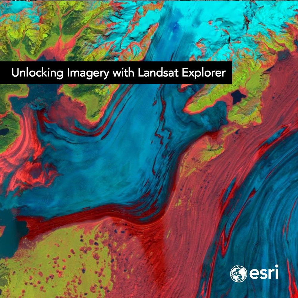
From urban expansion to the shrinking of lakes, the Landsat Explorer app in ArcGIS Living Atlas of the World provides an easy way for users to access and interpret #Landsat satellite data. 🛰️
🔹Learn more: esri.social/OzBu50Uc3rv
#ArcGISLivingAtlas
🔹Learn more: esri.social/OzBu50Uc3rv
#ArcGISLivingAtlas
December 2, 2024 at 6:20 PM
From urban expansion to the shrinking of lakes, the Landsat Explorer app in ArcGIS Living Atlas of the World provides an easy way for users to access and interpret #Landsat satellite data. 🛰️
🔹Learn more: esri.social/OzBu50Uc3rv
#ArcGISLivingAtlas
🔹Learn more: esri.social/OzBu50Uc3rv
#ArcGISLivingAtlas
Using interactive maps to explore data, illuminate patterns, and uncover relationships helps K-12 students build critical thinking skills 💭 Esri provides mapping software and many free resources for integrating geographic content of all types 🗺️
Explore: esri.social/XlN750UgNs3
Explore: esri.social/XlN750UgNs3

November 29, 2024 at 4:12 PM
Using interactive maps to explore data, illuminate patterns, and uncover relationships helps K-12 students build critical thinking skills 💭 Esri provides mapping software and many free resources for integrating geographic content of all types 🗺️
Explore: esri.social/XlN750UgNs3
Explore: esri.social/XlN750UgNs3
#Academics: Have you ever wondered how to cite #Landsat data? ow.ly/9ali50UbuUA
#OpenData #DataCitation (via USGSLandsat(X))
#OpenData #DataCitation (via USGSLandsat(X))

November 27, 2024 at 5:27 PM
#Academics: Have you ever wondered how to cite #Landsat data? ow.ly/9ali50UbuUA
#OpenData #DataCitation (via USGSLandsat(X))
#OpenData #DataCitation (via USGSLandsat(X))
Exploring. #Maps at #NCSS2024 in Boston today. #NetGeo mapmaker, #GeoInquiries, and #StoryMaps driving teacher interest. ESRI booth 717. #Geography


November 23, 2024 at 4:06 PM
Exploring. #Maps at #NCSS2024 in Boston today. #NetGeo mapmaker, #GeoInquiries, and #StoryMaps driving teacher interest. ESRI booth 717. #Geography
talking about maps and sharing the power of Geo spatial data at #NCSS2024 in booth 717. #LuggageTags #Stickers 🌎
November 23, 2024 at 2:52 PM
talking about maps and sharing the power of Geo spatial data at #NCSS2024 in booth 717. #LuggageTags #Stickers 🌎
GIS Day 2024 is tomorrow - Nov 20. It’s a great day to share the power of spatial thinking with students and the public. Find resources and see what others are doing. www.gisday.com #geography #NCSS2024 #GIS #geoscience #edusky #sschat

November 19, 2024 at 1:47 PM
GIS Day 2024 is tomorrow - Nov 20. It’s a great day to share the power of spatial thinking with students and the public. Find resources and see what others are doing. www.gisday.com #geography #NCSS2024 #GIS #geoscience #edusky #sschat
Several months ago, I began experimenting with #Ai generated maps (art). This is from Midjourney. #aiart #midjourneyart

November 17, 2024 at 12:57 AM
Several months ago, I began experimenting with #Ai generated maps (art). This is from Midjourney. #aiart #midjourneyart
The GeoInquiries Earth Science collection teaches map-based concepts for middle-high school students on topics ranging from topography, earthquakes, volcanoes, oceans, and more! 🌋
Explore the collection of activities 🗺️https://esri.com/geoinquiries #GIS #geography #science #edtech #teachers
Explore the collection of activities 🗺️https://esri.com/geoinquiries #GIS #geography #science #edtech #teachers

November 16, 2024 at 3:18 PM
The GeoInquiries Earth Science collection teaches map-based concepts for middle-high school students on topics ranging from topography, earthquakes, volcanoes, oceans, and more! 🌋
Explore the collection of activities 🗺️https://esri.com/geoinquiries #GIS #geography #science #edtech #teachers
Explore the collection of activities 🗺️https://esri.com/geoinquiries #GIS #geography #science #edtech #teachers
If you are an educator and use or teach with geospatial technologies, see this starter pack. Let me know if you should be added to it. 👉🏻 go.bsky.app/MUeVYC7

November 14, 2024 at 2:28 PM
If you are an educator and use or teach with geospatial technologies, see this starter pack. Let me know if you should be added to it. 👉🏻 go.bsky.app/MUeVYC7
Next week, I head over to where #SocialStudies meets #GIS:
ncss.org . Join the Esri #K12 team at NCSS 2024, where we’ll be sharing the latest in GIS tech for the classroom! Hope to see you there (in booth #717) 👉 community.esri.com/t5/education... @gis4schools.bsky.social
ncss.org . Join the Esri #K12 team at NCSS 2024, where we’ll be sharing the latest in GIS tech for the classroom! Hope to see you there (in booth #717) 👉 community.esri.com/t5/education... @gis4schools.bsky.social

November 13, 2024 at 3:13 PM
Next week, I head over to where #SocialStudies meets #GIS:
ncss.org . Join the Esri #K12 team at NCSS 2024, where we’ll be sharing the latest in GIS tech for the classroom! Hope to see you there (in booth #717) 👉 community.esri.com/t5/education... @gis4schools.bsky.social
ncss.org . Join the Esri #K12 team at NCSS 2024, where we’ll be sharing the latest in GIS tech for the classroom! Hope to see you there (in booth #717) 👉 community.esri.com/t5/education... @gis4schools.bsky.social
The Esri Wildfire Aware app provides information on the current status and potential impact of wildfire incidents in the US. ow.ly/k9CR50U3N0S

November 11, 2024 at 4:03 PM
The Esri Wildfire Aware app provides information on the current status and potential impact of wildfire incidents in the US. ow.ly/k9CR50U3N0S
Educators in need of resources to modernize your curriculum to #webGIS check out this webpage: www.esri.com/en-us/indust...
You'll get access to:
🔹 Core concepts of #modernGIS
🔹 Case studies
🔹 Curriculum resources
🔹 Training recommendations
🔹 Articles and blogs. (From @GISEd on X)
You'll get access to:
🔹 Core concepts of #modernGIS
🔹 Case studies
🔹 Curriculum resources
🔹 Training recommendations
🔹 Articles and blogs. (From @GISEd on X)

November 8, 2024 at 10:00 PM
Educators in need of resources to modernize your curriculum to #webGIS check out this webpage: www.esri.com/en-us/indust...
You'll get access to:
🔹 Core concepts of #modernGIS
🔹 Case studies
🔹 Curriculum resources
🔹 Training recommendations
🔹 Articles and blogs. (From @GISEd on X)
You'll get access to:
🔹 Core concepts of #modernGIS
🔹 Case studies
🔹 Curriculum resources
🔹 Training recommendations
🔹 Articles and blogs. (From @GISEd on X)