


TR Baker
@trbaker.bsky.social
💙🌎📻📸Teacher. Author. GIS education. EdTech. Former university research prof. Kansas Earth science teacher. GIS and XR. #EduSky
Teaching erosional concepts with MapMaker Some landforms are shaped over time through the geomorphic process of erosion. #GIS #earthscience #teachers #geography #educators
More: www.linkedin.com/pulse/teachi...
More: www.linkedin.com/pulse/teachi...
October 8, 2025 at 6:11 PM
Teaching erosional concepts with MapMaker Some landforms are shaped over time through the geomorphic process of erosion. #GIS #earthscience #teachers #geography #educators
More: www.linkedin.com/pulse/teachi...
More: www.linkedin.com/pulse/teachi...
New blog: Teaching topography (September's Earth science resource) community.esri.com/t5/education... Free software and materials for the geography and earth science classroom.

Teaching topography (September's Earth science resource)
Teaching topography and topographic maps are important in Earth science and physical geography; it builds a foundation for understanding how the surface of the Earth shapes natural processes, ecosyste...
community.esri.com
September 9, 2025 at 3:47 PM
New blog: Teaching topography (September's Earth science resource) community.esri.com/t5/education... Free software and materials for the geography and earth science classroom.
The ArcGIS for Schools Bundle license period has been extended. Learn more: community.esri.com/t5/education... #GIS #geography #K12 #APHG #edtech

April 24, 2025 at 8:28 PM
The ArcGIS for Schools Bundle license period has been extended. Learn more: community.esri.com/t5/education... #GIS #geography #K12 #APHG #edtech
GIS and special education teacher training program in Georgia. www.esri.com/en-us/lg/ind... #STEM #science #teachers #GIS

Developing a STEM & SPED Learning Program for High Schools
Faculty at the University of North Georgia developed a program called GeoEd, introducing high school STEM and SPED teachers and students to GIS and geoscience.
www.esri.com
March 31, 2025 at 3:39 PM
GIS and special education teacher training program in Georgia. www.esri.com/en-us/lg/ind... #STEM #science #teachers #GIS
Teachers: Get the kids outside this spring with GIS! community.esri.com/t5/education...

Get the kids outside this spring with GIS!
As spring rolls across the northern hemisphere, many students (and teachers) long to get outdoors. It’s a great opportunity to engage kids in field data work. +++ Ask the question Whether the teache...
community.esri.com
March 7, 2025 at 5:19 PM
Teachers: Get the kids outside this spring with GIS! community.esri.com/t5/education...
There are groups of data librarians, researchers working on a efforts to quickly triage and move US federal data to safer sites. Most of the data to DataLumos Project- www.datalumos.org/datalumos/
Environmental data - envirodatagov.org
More info - www.datarescueproject.org #GIS #geography
Environmental data - envirodatagov.org
More info - www.datarescueproject.org #GIS #geography
DataLumos
www.datalumos.org
February 14, 2025 at 7:16 PM
There are groups of data librarians, researchers working on a efforts to quickly triage and move US federal data to safer sites. Most of the data to DataLumos Project- www.datalumos.org/datalumos/
Environmental data - envirodatagov.org
More info - www.datarescueproject.org #GIS #geography
Environmental data - envirodatagov.org
More info - www.datarescueproject.org #GIS #geography
"The US Board on Geographic Names (BGN) has changed the name of the Gulf of Mexico to Gulf of America." The link is a good overview of the processes and systems engaged to affect the name changes on maps and spatial data from the US. www.sco.wisc.edu/2025/02/11/f...
Farewell to the Gulf of Mexico
It’s official.
www.sco.wisc.edu
February 14, 2025 at 5:27 PM
"The US Board on Geographic Names (BGN) has changed the name of the Gulf of Mexico to Gulf of America." The link is a good overview of the processes and systems engaged to affect the name changes on maps and spatial data from the US. www.sco.wisc.edu/2025/02/11/f...
Nat Geog Society launched a request for proposals, Spatial Thinking: Inspiring Place Based Solutions - seeking proposals that identify a challenge related to a place and leverages an edu solution using spatial thinking. www.nationalgeographic.org/society/gran... #GIS #geography #edusky

Spatial Thinking: Inspiring Action through Place-Based Solutions - National Geographic Society
This funding opportunity supports projects that identify a challenge related to a specific place and its unique conditions and leverages an educational solution using spatial thinking to enable people...
www.nationalgeographic.org
February 14, 2025 at 5:23 PM
Nat Geog Society launched a request for proposals, Spatial Thinking: Inspiring Place Based Solutions - seeking proposals that identify a challenge related to a place and leverages an edu solution using spatial thinking. www.nationalgeographic.org/society/gran... #GIS #geography #edusky
Mapping your course using tutorials for MapMaker community.esri.com/t5/education... #maps #GIS K-12 #schools #geography #ArcGIS #Edtech

Mapping your course using tutorials for MapMaker
The ArcGIS Tutorials team has created a series of modules that when completed, provide a great introduction to understanding the functionality of the National Geographic MapMaker. The series is suitab...
community.esri.com
February 13, 2025 at 7:22 PM
Mapping your course using tutorials for MapMaker community.esri.com/t5/education... #maps #GIS K-12 #schools #geography #ArcGIS #Edtech
Educator Gets #GIS for Every West Virginia K–12 Student! www.esri.com/en-us/lg/ind... @eklose.bsky.social #edusky #education #school #geo

Geologist Turned Educator Gets GIS for Every West Virginia K–12 Student
Dr. Erika Klose, a geologist turned educator, brings GIS technology to West Virginia’s K–12 students, enhancing learning and real-world data understanding.
www.esri.com
February 4, 2025 at 10:03 PM
Educator Gets #GIS for Every West Virginia K–12 Student! www.esri.com/en-us/lg/ind... @eklose.bsky.social #edusky #education #school #geo
Love LEGO? ❤️ Here's a fun Map of Wisconsin made with LEGOS and designed in #ArcGIS Pro
(1 brick=10 sq mi). The terrain is represented at different levels in elevation, with lakes and cities displayed.
Full map: esri.social/eBrZ50UoJwC
🗺️ 𝐴𝑢𝑡ℎ𝑜𝑟: 𝐴𝑡𝑙𝑎𝑠 𝐺𝑢𝑜
(1 brick=10 sq mi). The terrain is represented at different levels in elevation, with lakes and cities displayed.
Full map: esri.social/eBrZ50UoJwC
🗺️ 𝐴𝑢𝑡ℎ𝑜𝑟: 𝐴𝑡𝑙𝑎𝑠 𝐺𝑢𝑜

January 21, 2025 at 9:33 PM
Love LEGO? ❤️ Here's a fun Map of Wisconsin made with LEGOS and designed in #ArcGIS Pro
(1 brick=10 sq mi). The terrain is represented at different levels in elevation, with lakes and cities displayed.
Full map: esri.social/eBrZ50UoJwC
🗺️ 𝐴𝑢𝑡ℎ𝑜𝑟: 𝐴𝑡𝑙𝑎𝑠 𝐺𝑢𝑜
(1 brick=10 sq mi). The terrain is represented at different levels in elevation, with lakes and cities displayed.
Full map: esri.social/eBrZ50UoJwC
🗺️ 𝐴𝑢𝑡ℎ𝑜𝑟: 𝐴𝑡𝑙𝑎𝑠 𝐺𝑢𝑜
Career and technical education instructors can help increase students’ job readiness by building their professional GIS skills 💼
Explore #CTE resources, certifications, and more 👉 ow.ly/q9ZZ50UI8ir
Explore #CTE resources, certifications, and more 👉 ow.ly/q9ZZ50UI8ir

January 21, 2025 at 9:30 PM
Career and technical education instructors can help increase students’ job readiness by building their professional GIS skills 💼
Explore #CTE resources, certifications, and more 👉 ow.ly/q9ZZ50UI8ir
Explore #CTE resources, certifications, and more 👉 ow.ly/q9ZZ50UI8ir
Start your Near Year off right by incorporating National Geographic MapMaker into your curriculum! #NatGeoMapMaker equips teachers & learners with carefully curated maps, data, + activities for many subjects and grade levels.
Get started: esri.social/pHht50UymCb
#MappyNewYear
Get started: esri.social/pHht50UymCb
#MappyNewYear

January 10, 2025 at 7:42 PM
Start your Near Year off right by incorporating National Geographic MapMaker into your curriculum! #NatGeoMapMaker equips teachers & learners with carefully curated maps, data, + activities for many subjects and grade levels.
Get started: esri.social/pHht50UymCb
#MappyNewYear
Get started: esri.social/pHht50UymCb
#MappyNewYear
Where Do Christmas Trees Grow in the US? More than 25 million #Christmas trees are harvested in the U.S. each year. www.maps.com/where-christ... #geography #climate #GIS #solstice #holidays

December 19, 2024 at 8:16 PM
Where Do Christmas Trees Grow in the US? More than 25 million #Christmas trees are harvested in the U.S. each year. www.maps.com/where-christ... #geography #climate #GIS #solstice #holidays
Maps are powerful. 🗺️ They can spark curiosity, entertain, provide insight, and even drive people to take action that unites our world.
🔸Explore a gallery of inspiring maps: esri.social/MALE50Uclr5
#GIS #academicsky #Esri
🔸Explore a gallery of inspiring maps: esri.social/MALE50Uclr5
#GIS #academicsky #Esri


December 18, 2024 at 10:09 PM
Maps are powerful. 🗺️ They can spark curiosity, entertain, provide insight, and even drive people to take action that unites our world.
🔸Explore a gallery of inspiring maps: esri.social/MALE50Uclr5
#GIS #academicsky #Esri
🔸Explore a gallery of inspiring maps: esri.social/MALE50Uclr5
#GIS #academicsky #Esri
Educators! 🌟 Use this to help secondary students explore #GIS: esri.social/eGpE50UqhUZ #teachers #edusky #geography
Students will:
🔹View & identify map features & patterns
🔹Use GIS tools to analyze a problem
🔹Create a GIS web app that tells a story
🔹Describe how GIS helps people do their work
Students will:
🔹View & identify map features & patterns
🔹Use GIS tools to analyze a problem
🔹Create a GIS web app that tells a story
🔹Describe how GIS helps people do their work

December 18, 2024 at 10:04 PM
Educators! 🌟 Use this to help secondary students explore #GIS: esri.social/eGpE50UqhUZ #teachers #edusky #geography
Students will:
🔹View & identify map features & patterns
🔹Use GIS tools to analyze a problem
🔹Create a GIS web app that tells a story
🔹Describe how GIS helps people do their work
Students will:
🔹View & identify map features & patterns
🔹Use GIS tools to analyze a problem
🔹Create a GIS web app that tells a story
🔹Describe how GIS helps people do their work
Registration is now open for the #Esri #GIS Education Summit
taking place July 12-15, 2025 in San Diego, California. www.esri.com/en-us/about/... #geoscience #geography
taking place July 12-15, 2025 in San Diego, California. www.esri.com/en-us/about/... #geoscience #geography

Esri Education Summit July 12–15, 2025
Join us for the Esri Education Summit in San Diego, CA. Find innovative strategies for teaching and discover how institutions are employing GIS in classrooms and across campuses.
www.esri.com
December 16, 2024 at 5:19 PM
Registration is now open for the #Esri #GIS Education Summit
taking place July 12-15, 2025 in San Diego, California. www.esri.com/en-us/about/... #geoscience #geography
taking place July 12-15, 2025 in San Diego, California. www.esri.com/en-us/about/... #geoscience #geography
The Audubon society Bird Migration Explorer is your guide to the heroic journeys made by over 450 bird species, and the challenges they face along the way. 🐦
🔸Explore the map: explorer.audubon.org/home #GIS #geography #bio #science
🔸Explore the map: explorer.audubon.org/home #GIS #geography #bio #science

December 16, 2024 at 1:36 PM
The Audubon society Bird Migration Explorer is your guide to the heroic journeys made by over 450 bird species, and the challenges they face along the way. 🐦
🔸Explore the map: explorer.audubon.org/home #GIS #geography #bio #science
🔸Explore the map: explorer.audubon.org/home #GIS #geography #bio #science
Happy Computer Science Education Week! 💻 Did you know that Esri offers a learn tutorial on GIS for computer science CTE programs? 👀 Check it out: esri.social/hH0E50Uotvp
#CSEdWeek #CTE #EduSky
#CSEdWeek #CTE #EduSky

GIS for computer science CTE programs (JavaScript)
See the role of GIS in computer science CTE. Use the spatial lens of GIS to help students in the career cluster for information technology understand data processing, display customization, and websit...
esri.social
December 13, 2024 at 6:58 PM
Happy Computer Science Education Week! 💻 Did you know that Esri offers a learn tutorial on GIS for computer science CTE programs? 👀 Check it out: esri.social/hH0E50Uotvp
#CSEdWeek #CTE #EduSky
#CSEdWeek #CTE #EduSky

📝 Blogged: iNaturalist data mapping in ArcGIS 3D viewer and MapMaker for #teachers. 🦃 🦉 🧸 🦊 🐿️ 🦫 See: community.esri.com/t5/education... #geography #biology #GIS #edusky

A STEM educator's introduction to iNaturalist data in ArcGIS
Over the summer, Esri announced that the iNaturalist observations are now available in the ArcGIS Living Atlas of the World with over 800,000 naturalists who have recorded over 90 million observations...
community.esri.com
December 10, 2024 at 10:14 PM
📝 Blogged: iNaturalist data mapping in ArcGIS 3D viewer and MapMaker for #teachers. 🦃 🦉 🧸 🦊 🐿️ 🦫 See: community.esri.com/t5/education... #geography #biology #GIS #edusky
📍 Mapped: #US Home Price-to-Income Ratio By State (June 2024) Thanks @josephkerski.bsky.social www.visualcapitalist.com/mapped-home-... 🗺️ So many things said and unsaid in one map. #geography #sschat #socialstudies #economics

December 6, 2024 at 6:16 PM
📍 Mapped: #US Home Price-to-Income Ratio By State (June 2024) Thanks @josephkerski.bsky.social www.visualcapitalist.com/mapped-home-... 🗺️ So many things said and unsaid in one map. #geography #sschat #socialstudies #economics
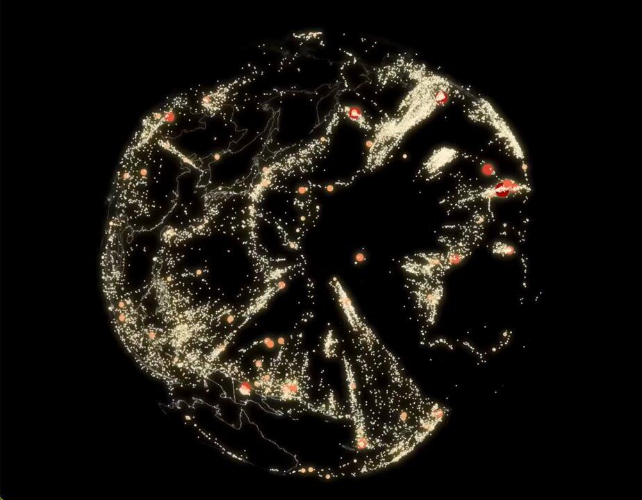
You're looking at earthquakes from inside the Earth. 🌏 Created by Raluca Nicola with the ArcGIS Maps SDK for JavaScript.
🔸Explore the app here: esri.social/BmH650UlkeR
#ArcGIS #JavaScript #geoscience #geography #edusky
🔸Explore the app here: esri.social/BmH650UlkeR
#ArcGIS #JavaScript #geoscience #geography #edusky
December 5, 2024 at 4:55 PM
You're looking at earthquakes from inside the Earth. 🌏 Created by Raluca Nicola with the ArcGIS Maps SDK for JavaScript.
🔸Explore the app here: esri.social/BmH650UlkeR
#ArcGIS #JavaScript #geoscience #geography #edusky
🔸Explore the app here: esri.social/BmH650UlkeR
#ArcGIS #JavaScript #geoscience #geography #edusky
I talked with a resourceful Earth science teacher today who is still using ArcView 3 on a Windows XP computer in his classroom! 🤯 Amazing! He is now set to upgrade to ArcGIS Online later this month. 👍😀 ArcView 3 was released in 1992. 💾 📠📞 #GIS #Esri @josephkerski.bsky.social #geography

December 4, 2024 at 9:19 PM
I talked with a resourceful Earth science teacher today who is still using ArcView 3 on a Windows XP computer in his classroom! 🤯 Amazing! He is now set to upgrade to ArcGIS Online later this month. 👍😀 ArcView 3 was released in 1992. 💾 📠📞 #GIS #Esri @josephkerski.bsky.social #geography
🔥 Scientists are revolutionizing fossil tracking by utilizing RFID tags and GIS mapping to create a shared map that will document dinosaur fossils discovered worldwide.🦕 esri.social/OwGo50T8WuF #geoscience

Mapping Dinosaur Fossils, from Dig to Display
The Earth Sciences Foundation is creating a real-time map of dinosaur bone locations with RFID tagging and GIS mapping.
esri.social
December 4, 2024 at 9:01 PM
🔥 Scientists are revolutionizing fossil tracking by utilizing RFID tags and GIS mapping to create a shared map that will document dinosaur fossils discovered worldwide.🦕 esri.social/OwGo50T8WuF #geoscience