


London & Southeast🔅
@thesnowdreamer.bsky.social
A clear, cold and frosty start to tomorrow morning…. judging by the westerly driven outlook, it might be the last in a while.

November 25, 2025 at 8:15 PM
A clear, cold and frosty start to tomorrow morning…. judging by the westerly driven outlook, it might be the last in a while.
Tropical compared to some spots….

November 23, 2025 at 9:14 PM
Tropical compared to some spots….
I think the hope would be tropical forcing steering these heights more northwards to Scandi, the added complication is stratospheric zonal wind, but forecasts remain for a weaker vortex through Dec. (2/3)

November 23, 2025 at 9:07 PM
I think the hope would be tropical forcing steering these heights more northwards to Scandi, the added complication is stratospheric zonal wind, but forecasts remain for a weaker vortex through Dec. (2/3)
Heading through rest of Nov & early December the pattern is clearly zonal 🌧️💨 (+NAO) there are robust signs of subtropical ridge influence into 2nd week of Dec, this would likely result in even milder temperatures in UK/Europe while possibly drier. (1/3)
November 23, 2025 at 9:07 PM
Heading through rest of Nov & early December the pattern is clearly zonal 🌧️💨 (+NAO) there are robust signs of subtropical ridge influence into 2nd week of Dec, this would likely result in even milder temperatures in UK/Europe while possibly drier. (1/3)
First and the last day this week it has crept into double figures in London.
The cold spell continues strongly in central Europe and separately exceptional cold wave in N Scandinavia. Far southeast is exceptionally warm in Turkey #Istanbul temperatures reached 21C (70F) this afternoon.
The cold spell continues strongly in central Europe and separately exceptional cold wave in N Scandinavia. Far southeast is exceptionally warm in Turkey #Istanbul temperatures reached 21C (70F) this afternoon.

November 23, 2025 at 3:49 PM
First and the last day this week it has crept into double figures in London.
The cold spell continues strongly in central Europe and separately exceptional cold wave in N Scandinavia. Far southeast is exceptionally warm in Turkey #Istanbul temperatures reached 21C (70F) this afternoon.
The cold spell continues strongly in central Europe and separately exceptional cold wave in N Scandinavia. Far southeast is exceptionally warm in Turkey #Istanbul temperatures reached 21C (70F) this afternoon.
Our earlier rain is giving widespread snowfall in France tonight. The warm front will turn snow to rain overnight but large areas will see 1-5cm before that.

November 22, 2025 at 9:46 PM
Our earlier rain is giving widespread snowfall in France tonight. The warm front will turn snow to rain overnight but large areas will see 1-5cm before that.
Not pretty! Heaviest rain affecting N London/Herts 🌧️🌧️

November 22, 2025 at 3:53 PM
Not pretty! Heaviest rain affecting N London/Herts 🌧️🌧️
The difference in a day!


November 22, 2025 at 3:20 PM
The difference in a day!

Persistent steady rain now moving into west London area.

November 22, 2025 at 2:40 PM
Persistent steady rain now moving into west London area.
Some quite heavy rain is moving eastwards across Southern England about an hour from London!

November 22, 2025 at 1:37 PM
Some quite heavy rain is moving eastwards across Southern England about an hour from London!
After yesterday’s brilliant blue skies we’ve fallen back with a bump, more typical conditions what you expect this time of year.
White capped Alps / Pyrenees being well highlighted this afternoon following recent snowfall - excellent skiing conditions ☀️❄️⛷️
White capped Alps / Pyrenees being well highlighted this afternoon following recent snowfall - excellent skiing conditions ☀️❄️⛷️
November 22, 2025 at 1:31 PM
After yesterday’s brilliant blue skies we’ve fallen back with a bump, more typical conditions what you expect this time of year.
White capped Alps / Pyrenees being well highlighted this afternoon following recent snowfall - excellent skiing conditions ☀️❄️⛷️
White capped Alps / Pyrenees being well highlighted this afternoon following recent snowfall - excellent skiing conditions ☀️❄️⛷️
London Heathrow's annual frost number days (1949-2025*) where minimum temperature falls below 0C (32F).
Currently, 2025 stands at 26 days with still December to come, this is above recent decadal average. It has felt like a frostier year, but certainly an element of shifting baseline syndrome.
Currently, 2025 stands at 26 days with still December to come, this is above recent decadal average. It has felt like a frostier year, but certainly an element of shifting baseline syndrome.

November 21, 2025 at 8:10 PM
London Heathrow's annual frost number days (1949-2025*) where minimum temperature falls below 0C (32F).
Currently, 2025 stands at 26 days with still December to come, this is above recent decadal average. It has felt like a frostier year, but certainly an element of shifting baseline syndrome.
Currently, 2025 stands at 26 days with still December to come, this is above recent decadal average. It has felt like a frostier year, but certainly an element of shifting baseline syndrome.
Cold Friday evening many places in south and east already subzero.
Frost will thaw by dawn with cloud and light rain approaching. Still chilly highs of 7C in London, a more notable warm up will occur next Thursday with temps in the teens…
Frost will thaw by dawn with cloud and light rain approaching. Still chilly highs of 7C in London, a more notable warm up will occur next Thursday with temps in the teens…


November 21, 2025 at 7:46 PM
Cold Friday evening many places in south and east already subzero.
Frost will thaw by dawn with cloud and light rain approaching. Still chilly highs of 7C in London, a more notable warm up will occur next Thursday with temps in the teens…
Frost will thaw by dawn with cloud and light rain approaching. Still chilly highs of 7C in London, a more notable warm up will occur next Thursday with temps in the teens…
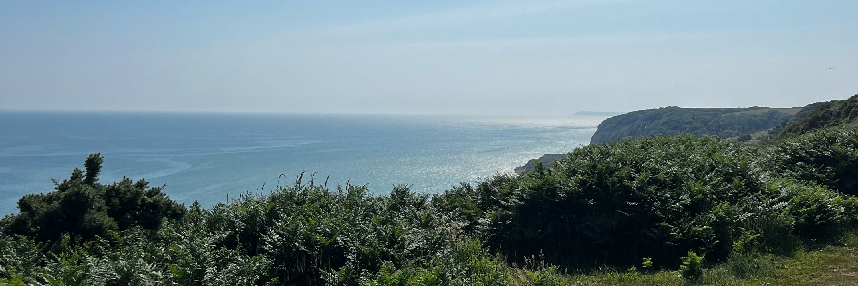
Stunning blue sky day in London the bluest skies I’ve seen in a long time.
In deep November something to be savoured! #Rotherhithe #Docklands
In deep November something to be savoured! #Rotherhithe #Docklands


November 21, 2025 at 1:55 PM
Stunning blue sky day in London the bluest skies I’ve seen in a long time.
In deep November something to be savoured! #Rotherhithe #Docklands
In deep November something to be savoured! #Rotherhithe #Docklands
Clear blue skies to start Friday and cold! A bit more of a breeze in SE generally kept temps a little less cold.
It was also coldest night of ‘winter’ preliminary minimum of -11.7C (11F) at Loch Glascanoch in N Scotland 🥶
It was also coldest night of ‘winter’ preliminary minimum of -11.7C (11F) at Loch Glascanoch in N Scotland 🥶

November 21, 2025 at 8:18 AM
Clear blue skies to start Friday and cold! A bit more of a breeze in SE generally kept temps a little less cold.
It was also coldest night of ‘winter’ preliminary minimum of -11.7C (11F) at Loch Glascanoch in N Scotland 🥶
It was also coldest night of ‘winter’ preliminary minimum of -11.7C (11F) at Loch Glascanoch in N Scotland 🥶


A rather cold 3C at lunchtime for most places, not quite feeling as cold as yesterday with northerly wind not as strong.

November 20, 2025 at 12:57 PM
A rather cold 3C at lunchtime for most places, not quite feeling as cold as yesterday with northerly wind not as strong.
Cold 🥶 -6C in Benson and rounded -1C in central London not much frost visible though, dry air.


November 20, 2025 at 7:14 AM
Cold 🥶 -6C in Benson and rounded -1C in central London not much frost visible though, dry air.
NE Scotland including #Aberdeen getting clobbered by persistent ‘lake effect’ snow with a lot more to come overnight.
The yellow snow warning is evidently not sufficient - wide area away from immediate coasts likely will see 10-20cm. Significant travel disruption expected Thursday AM.
The yellow snow warning is evidently not sufficient - wide area away from immediate coasts likely will see 10-20cm. Significant travel disruption expected Thursday AM.
November 19, 2025 at 10:37 PM
NE Scotland including #Aberdeen getting clobbered by persistent ‘lake effect’ snow with a lot more to come overnight.
The yellow snow warning is evidently not sufficient - wide area away from immediate coasts likely will see 10-20cm. Significant travel disruption expected Thursday AM.
The yellow snow warning is evidently not sufficient - wide area away from immediate coasts likely will see 10-20cm. Significant travel disruption expected Thursday AM.
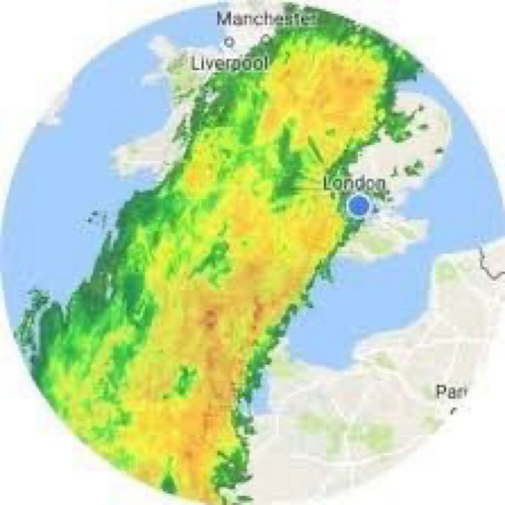
Some of most colder than average temperatures on planet Earth are currently across England and Nordics.

November 19, 2025 at 10:12 PM
Some of most colder than average temperatures on planet Earth are currently across England and Nordics.
A cold night to come even centre of London is expected to slip below freezing. With earlier rain/snow be wary of slippery surfaces.

November 19, 2025 at 7:08 PM
A cold night to come even centre of London is expected to slip below freezing. With earlier rain/snow be wary of slippery surfaces.
Cold mid November day high of 5.1C in inner south London with the cold northerly wind feels like temperatures have been widely subzero.

November 19, 2025 at 4:00 PM
Cold mid November day high of 5.1C in inner south London with the cold northerly wind feels like temperatures have been widely subzero.
Most of our region will see a spell of cold ☔️ tomorrow morning.
It may have a more wintry flavour on back edge later in morn, but more likely sleety rain to low levels. The risk is higher to W of London - possible snow might briefly accumulate on highest ground of Chilterns ect.
It may have a more wintry flavour on back edge later in morn, but more likely sleety rain to low levels. The risk is higher to W of London - possible snow might briefly accumulate on highest ground of Chilterns ect.


November 18, 2025 at 8:53 PM
Most of our region will see a spell of cold ☔️ tomorrow morning.
It may have a more wintry flavour on back edge later in morn, but more likely sleety rain to low levels. The risk is higher to W of London - possible snow might briefly accumulate on highest ground of Chilterns ect.
It may have a more wintry flavour on back edge later in morn, but more likely sleety rain to low levels. The risk is higher to W of London - possible snow might briefly accumulate on highest ground of Chilterns ect.