


Romain Fourmy
@romainfourmy.bsky.social
Geospatial & Earth Observation Expert 🌍| 🛰️ Transforming views from above into insights
🛰️ Satellite imagery won’t replace fieldwork — but it can take you much further than you think.
www.linkedin.com/pulse/just-t...
www.linkedin.com/pulse/just-t...

Not Just Theory: Lessons from Using Satellite Imagery in Real-Life Impact Evaluation
Discover how satellite imagery can fill data gaps, support impact evaluation, and generate actionable insights when combined with field knowledge.
www.linkedin.com
May 7, 2025 at 7:58 AM
🛰️ Satellite imagery won’t replace fieldwork — but it can take you much further than you think.
www.linkedin.com/pulse/just-t...
www.linkedin.com/pulse/just-t...
Reposted by Romain Fourmy
#WomensHistoryMonth Day 16: Esther Duflo revolutionized the fight against poverty by applying data-driven research and GIS analysis. A Nobel Laureate in Economics, she maps the impact of infrastructure & policies on communities, ensuring interventions truly work. #Shero #GISChat

March 16, 2025 at 3:47 PM
#WomensHistoryMonth Day 16: Esther Duflo revolutionized the fight against poverty by applying data-driven research and GIS analysis. A Nobel Laureate in Economics, she maps the impact of infrastructure & policies on communities, ensuring interventions truly work. #Shero #GISChat
Reposted by Romain Fourmy
⏰𝗥𝗲𝗺𝗶𝗻𝗱𝗲𝗿⏰
The #Sentinel-2A extension campaign begins in 𝘁𝘄𝗼 days, improving the global revisit frequency of the Sentinel-2 constellation. Particularly beneficial for observing tropical regions in Africa and South America with high #cloud cover.
buff.ly/lTEENhP
#earthobs #remotesensing
The #Sentinel-2A extension campaign begins in 𝘁𝘄𝗼 days, improving the global revisit frequency of the Sentinel-2 constellation. Particularly beneficial for observing tropical regions in Africa and South America with high #cloud cover.
buff.ly/lTEENhP
#earthobs #remotesensing
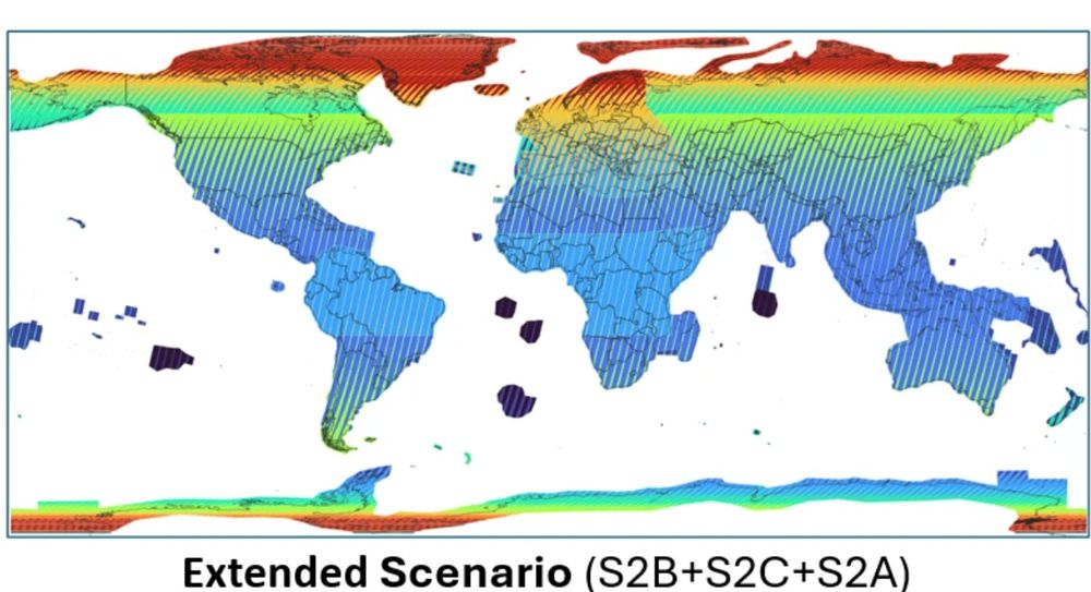
Sentinel-2A: Extended Campaign Starting March 13, 2025
Copernicus Data Space Ecosystem - Europe's eyes on Earth
buff.ly
March 11, 2025 at 7:02 AM
⏰𝗥𝗲𝗺𝗶𝗻𝗱𝗲𝗿⏰
The #Sentinel-2A extension campaign begins in 𝘁𝘄𝗼 days, improving the global revisit frequency of the Sentinel-2 constellation. Particularly beneficial for observing tropical regions in Africa and South America with high #cloud cover.
buff.ly/lTEENhP
#earthobs #remotesensing
The #Sentinel-2A extension campaign begins in 𝘁𝘄𝗼 days, improving the global revisit frequency of the Sentinel-2 constellation. Particularly beneficial for observing tropical regions in Africa and South America with high #cloud cover.
buff.ly/lTEENhP
#earthobs #remotesensing
Reposted by Romain Fourmy

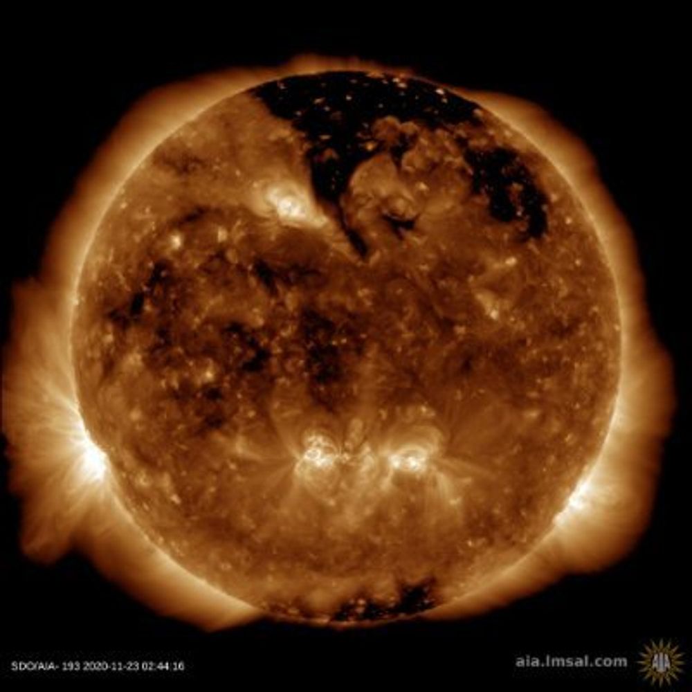
One of my favourite data discoveries this year: Google's mind-blowing ARCO-ERA5 dataset: hourly data for ~300 climate variables, available globally from 1940! 🤯
Loadable with a single line of Python code from a single cloud-friendly Zarr file! Below: a month of wind waves + swell: 🌊
Loadable with a single line of Python code from a single cloud-friendly Zarr file! Below: a month of wind waves + swell: 🌊
November 27, 2024 at 4:02 AM
One of my favourite data discoveries this year: Google's mind-blowing ARCO-ERA5 dataset: hourly data for ~300 climate variables, available globally from 1940! 🤯
Loadable with a single line of Python code from a single cloud-friendly Zarr file! Below: a month of wind waves + swell: 🌊
Loadable with a single line of Python code from a single cloud-friendly Zarr file! Below: a month of wind waves + swell: 🌊
Reposted by Romain Fourmy

We are lucky to be living on the most photogenic continent on the planet. This image from #Landsat taken yesterday shows the stunning Warmalana/Depuch Island in Western Australia. Check it out on #DigitalEarthAu Maps tinyurl.com/3ufr5f7a

November 21, 2024 at 6:08 AM
We are lucky to be living on the most photogenic continent on the planet. This image from #Landsat taken yesterday shows the stunning Warmalana/Depuch Island in Western Australia. Check it out on #DigitalEarthAu Maps tinyurl.com/3ufr5f7a
Reposted by Romain Fourmy

🚀 Foursquare just launched Open Source Places (FSQ OS Places), a foundational open dataset featuring 100M+ global places of interest (POIs) with 22 core attributes. The dataset will be updated monthly!
🔗 Blog Post: lnkd.in/ehWVbNvq
📥 Access the data: opensource.foursquare.com/os-places
#geospatial
🔗 Blog Post: lnkd.in/ehWVbNvq
📥 Access the data: opensource.foursquare.com/os-places
#geospatial

November 20, 2024 at 3:17 PM
🚀 Foursquare just launched Open Source Places (FSQ OS Places), a foundational open dataset featuring 100M+ global places of interest (POIs) with 22 core attributes. The dataset will be updated monthly!
🔗 Blog Post: lnkd.in/ehWVbNvq
📥 Access the data: opensource.foursquare.com/os-places
#geospatial
🔗 Blog Post: lnkd.in/ehWVbNvq
📥 Access the data: opensource.foursquare.com/os-places
#geospatial
Reposted by Romain Fourmy
Anthropogenic climate change doubled the frequency of compound drought and heatwaves in low-income regions
www.nature.com/articles/s43...
www.nature.com/articles/s43...

Anthropogenic climate change doubled the frequency of compound drought and heatwaves in low-income regions - Communications Earth & Environment
From 1981 to 2020, low-income regions experienced a faster increase in the frequency of compound drought-heatwaves events than high-income regions, and the increase is attributed to anthropogenic clim...
www.nature.com
November 19, 2024 at 11:42 AM
Anthropogenic climate change doubled the frequency of compound drought and heatwaves in low-income regions
www.nature.com/articles/s43...
www.nature.com/articles/s43...
Reposted by Romain Fourmy
Queridos periodistas,
No se debe usar "desastre/catástrofe natural". Los desastres provocados por riesgos naturales son siempre el resultado de las acciones y las decisiones humanas. Un desastre no es natural y que las acciones humanas pueden prevenir y mitigar sus impactos. Aquí otros conceptos:
No se debe usar "desastre/catástrofe natural". Los desastres provocados por riesgos naturales son siempre el resultado de las acciones y las decisiones humanas. Un desastre no es natural y que las acciones humanas pueden prevenir y mitigar sus impactos. Aquí otros conceptos:

November 18, 2024 at 3:48 PM
Queridos periodistas,
No se debe usar "desastre/catástrofe natural". Los desastres provocados por riesgos naturales son siempre el resultado de las acciones y las decisiones humanas. Un desastre no es natural y que las acciones humanas pueden prevenir y mitigar sus impactos. Aquí otros conceptos:
No se debe usar "desastre/catástrofe natural". Los desastres provocados por riesgos naturales son siempre el resultado de las acciones y las decisiones humanas. Un desastre no es natural y que las acciones humanas pueden prevenir y mitigar sus impactos. Aquí otros conceptos:
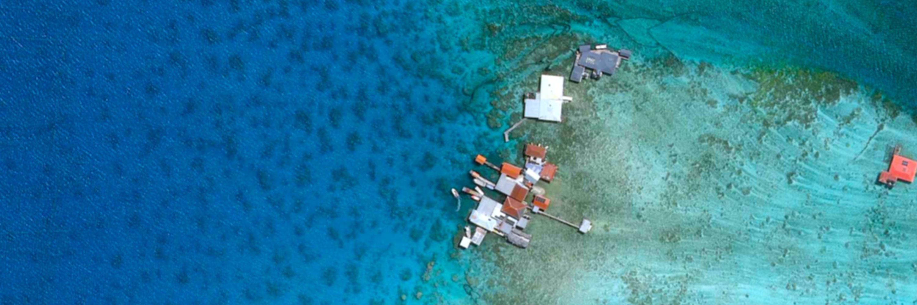
French Polynesia, Ocean Pacific 🏝️
Credits: Pléiades Neo, Airbus 2022
Credits: Pléiades Neo, Airbus 2022

November 18, 2024 at 2:56 PM
French Polynesia, Ocean Pacific 🏝️
Credits: Pléiades Neo, Airbus 2022
Credits: Pléiades Neo, Airbus 2022