


Jenna Storm Warner
@jennastormwarner.bsky.social
Arkansas Storm Team Meteorologist • University of Oklahoma BS’21 MS’23 • OH ✈️ OK ✈️ SC ✈️ AR
It's always fun to make out what shapes and figures you see in the clouds!! Sarah Migeot sent in this photo from Bryant this afternoon of a "fire-breathing dragon" protecting Bryant #arwx

November 25, 2025 at 9:51 PM
It's always fun to make out what shapes and figures you see in the clouds!! Sarah Migeot sent in this photo from Bryant this afternoon of a "fire-breathing dragon" protecting Bryant #arwx
That's some SERIOUS fog...
Karen Heatherly snapped this photo Monday afternoon just north of Clinton, Arkansas
Karen Heatherly snapped this photo Monday afternoon just north of Clinton, Arkansas

November 24, 2025 at 11:51 PM
That's some SERIOUS fog...
Karen Heatherly snapped this photo Monday afternoon just north of Clinton, Arkansas
Karen Heatherly snapped this photo Monday afternoon just north of Clinton, Arkansas
Today (Thursday, November 20th), there's a low to medium (levels 1 and 2 out of 4) risk of flooding and flash flooding with multiple rounds of showers and storms. The flooding potential is our biggest impact with today's and tonight's showers and storms.

November 20, 2025 at 12:09 PM
Today (Thursday, November 20th), there's a low to medium (levels 1 and 2 out of 4) risk of flooding and flash flooding with multiple rounds of showers and storms. The flooding potential is our biggest impact with today's and tonight's showers and storms.
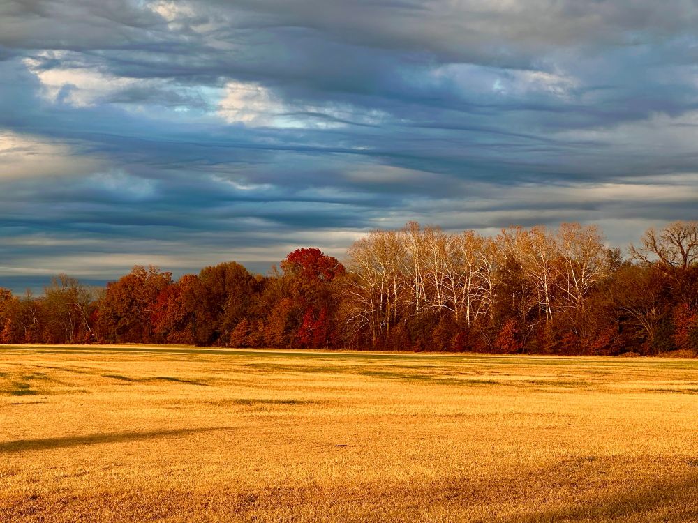
STUNNING
From the golden field to the red and orange fall trees, AND the wavy, gray/blue sky... A thousand words + to describe this phenomenal photo from Joyce Williams in Independence County 🍁🍂🌾
From the golden field to the red and orange fall trees, AND the wavy, gray/blue sky... A thousand words + to describe this phenomenal photo from Joyce Williams in Independence County 🍁🍂🌾
November 17, 2025 at 11:28 PM
STUNNING
From the golden field to the red and orange fall trees, AND the wavy, gray/blue sky... A thousand words + to describe this phenomenal photo from Joyce Williams in Independence County 🍁🍂🌾
From the golden field to the red and orange fall trees, AND the wavy, gray/blue sky... A thousand words + to describe this phenomenal photo from Joyce Williams in Independence County 🍁🍂🌾
The Northern Lights from Mountain View, Arkansas tonight🤩🤩🤩
Thanks for sending in this photo, 📸 Heather Mealer
Thanks for sending in this photo, 📸 Heather Mealer

November 12, 2025 at 4:14 AM
The Northern Lights from Mountain View, Arkansas tonight🤩🤩🤩
Thanks for sending in this photo, 📸 Heather Mealer
Thanks for sending in this photo, 📸 Heather Mealer
Freezing conditions = soup!! I made taco soup for us tonight😋

November 10, 2025 at 12:58 AM
Freezing conditions = soup!! I made taco soup for us tonight😋
How on schedule is this freeze tonight? Very on schedule, per the 30-year average across Arkansas. For Little Rock, it's right on the money even⤵🥶
This is just that time of year, but we're not used to it yet this season. Bundle up out there and stay warm😊
This is just that time of year, but we're not used to it yet this season. Bundle up out there and stay warm😊

November 10, 2025 at 12:23 AM
How on schedule is this freeze tonight? Very on schedule, per the 30-year average across Arkansas. For Little Rock, it's right on the money even⤵🥶
This is just that time of year, but we're not used to it yet this season. Bundle up out there and stay warm😊
This is just that time of year, but we're not used to it yet this season. Bundle up out there and stay warm😊
A Freeze Warning will be in effect from 9pm Sunday to 9am Monday for much of Arkansas. This is the coldest air so far this season, feeling even colder with the wind.
Pets should be indoors tonight. And if you haven't already, bring inside or cover sensitive plants.
Stay warm out there, Arkansas!
Pets should be indoors tonight. And if you haven't already, bring inside or cover sensitive plants.
Stay warm out there, Arkansas!


November 9, 2025 at 9:44 PM
A Freeze Warning will be in effect from 9pm Sunday to 9am Monday for much of Arkansas. This is the coldest air so far this season, feeling even colder with the wind.
Pets should be indoors tonight. And if you haven't already, bring inside or cover sensitive plants.
Stay warm out there, Arkansas!
Pets should be indoors tonight. And if you haven't already, bring inside or cover sensitive plants.
Stay warm out there, Arkansas!
And it was all yellow✨🍂🍁🎶
Melody Harrison captured this photo in Stone County on a bright, sunshine-y day☀️
Melody Harrison captured this photo in Stone County on a bright, sunshine-y day☀️

November 8, 2025 at 2:30 PM
And it was all yellow✨🍂🍁🎶
Melody Harrison captured this photo in Stone County on a bright, sunshine-y day☀️
Melody Harrison captured this photo in Stone County on a bright, sunshine-y day☀️
A Wind Advisory will be in effect on Wednesday from 4am-7pm as NW winds sustained to 25mph and gusts up to 35mph are expected. This will be valid for those in tan tomorrow.
If you have loose objects in the yard, like your Halloween decorations or trash cans, secure them or bring them inside
If you have loose objects in the yard, like your Halloween decorations or trash cans, secure them or bring them inside

October 28, 2025 at 4:56 PM
A Wind Advisory will be in effect on Wednesday from 4am-7pm as NW winds sustained to 25mph and gusts up to 35mph are expected. This will be valid for those in tan tomorrow.
If you have loose objects in the yard, like your Halloween decorations or trash cans, secure them or bring them inside
If you have loose objects in the yard, like your Halloween decorations or trash cans, secure them or bring them inside
Melissa is very close to making landfall in Jamaica as of 10am CDT. It'll be one of the strongest landfalling hurricanes in the Atlantic Basin in recorded history.
My thoughts are with the people of Jamaica. After the storm, I encourage you to donate to a reputable relief org, if you're able
My thoughts are with the people of Jamaica. After the storm, I encourage you to donate to a reputable relief org, if you're able

October 28, 2025 at 3:20 PM
Melissa is very close to making landfall in Jamaica as of 10am CDT. It'll be one of the strongest landfalling hurricanes in the Atlantic Basin in recorded history.
My thoughts are with the people of Jamaica. After the storm, I encourage you to donate to a reputable relief org, if you're able
My thoughts are with the people of Jamaica. After the storm, I encourage you to donate to a reputable relief org, if you're able
Major Hurricane Melissa... It's approaching historic levels. By late week, Melissa could have made 3 landfalls. Let's talk about the latest (as of Monday, October 27th, 4 pm CDT) on KARK4 News at 4pm with @toddyakoubian.bsky.social
October 27, 2025 at 9:46 PM
Major Hurricane Melissa... It's approaching historic levels. By late week, Melissa could have made 3 landfalls. Let's talk about the latest (as of Monday, October 27th, 4 pm CDT) on KARK4 News at 4pm with @toddyakoubian.bsky.social
Wow, Melissa EXPLODED overnight… Melissa underwent rapid intensification, going from a Cat 1 to a Cat 4 overnight. As of the 10am CDT NHC update, Melissa has max sustained winds of 140mph and is still crawling W at 3mph. Melissa will make a run at Cat 5 status tomorrow 🧵
October 26, 2025 at 5:03 PM
Wow, Melissa EXPLODED overnight… Melissa underwent rapid intensification, going from a Cat 1 to a Cat 4 overnight. As of the 10am CDT NHC update, Melissa has max sustained winds of 140mph and is still crawling W at 3mph. Melissa will make a run at Cat 5 status tomorrow 🧵
Robert Moore sent in a wall cloud from Gurdon this afternoon with the tornado-warned storm in Clark County.
Christopher, Joel, and Todd are live covering this warning now, so tune in for the latest
Posted 3:40pm Saturday
Christopher, Joel, and Todd are live covering this warning now, so tune in for the latest
Posted 3:40pm Saturday

October 18, 2025 at 8:40 PM
Robert Moore sent in a wall cloud from Gurdon this afternoon with the tornado-warned storm in Clark County.
Christopher, Joel, and Todd are live covering this warning now, so tune in for the latest
Posted 3:40pm Saturday
Christopher, Joel, and Todd are live covering this warning now, so tune in for the latest
Posted 3:40pm Saturday
3:17pm Saturday
A Tornado Watch has been issued until 8pm CDT for parts of central Arkansas. This includes Little Rock, Conway, Pine Bluff, Heber Springs, Camden, Arkadelphia, and Fordyce.
Have multiple ways to receive warning info for your location into tonight
A Tornado Watch has been issued until 8pm CDT for parts of central Arkansas. This includes Little Rock, Conway, Pine Bluff, Heber Springs, Camden, Arkadelphia, and Fordyce.
Have multiple ways to receive warning info for your location into tonight

October 18, 2025 at 8:22 PM
3:17pm Saturday
A Tornado Watch has been issued until 8pm CDT for parts of central Arkansas. This includes Little Rock, Conway, Pine Bluff, Heber Springs, Camden, Arkadelphia, and Fordyce.
Have multiple ways to receive warning info for your location into tonight
A Tornado Watch has been issued until 8pm CDT for parts of central Arkansas. This includes Little Rock, Conway, Pine Bluff, Heber Springs, Camden, Arkadelphia, and Fordyce.
Have multiple ways to receive warning info for your location into tonight
A Tornado Watch (yellow) has been issued for parts of southwestern Arkansas until 9pm CDT. A couple of discrete storms capable of tornadoes are possible within the yellow counties through the watch period. Hazards also include damaging wind gusts, hail, and frequent lightning.

October 18, 2025 at 7:04 PM
A Tornado Watch (yellow) has been issued for parts of southwestern Arkansas until 9pm CDT. A couple of discrete storms capable of tornadoes are possible within the yellow counties through the watch period. Hazards also include damaging wind gusts, hail, and frequent lightning.
11:19am Saturday
A Severe T-Storm Watch has been issued for those in pink until 6pm CDT. This means conditions are ripe for severe weather, with the main hazards being damaging wind gusts & hail. There’s a very low tornado risk, too. When thunder roars, head indoors
A Severe T-Storm Watch has been issued for those in pink until 6pm CDT. This means conditions are ripe for severe weather, with the main hazards being damaging wind gusts & hail. There’s a very low tornado risk, too. When thunder roars, head indoors

October 18, 2025 at 4:25 PM
11:19am Saturday
A Severe T-Storm Watch has been issued for those in pink until 6pm CDT. This means conditions are ripe for severe weather, with the main hazards being damaging wind gusts & hail. There’s a very low tornado risk, too. When thunder roars, head indoors
A Severe T-Storm Watch has been issued for those in pink until 6pm CDT. This means conditions are ripe for severe weather, with the main hazards being damaging wind gusts & hail. There’s a very low tornado risk, too. When thunder roars, head indoors
A line of showers and storms is likely to organize to our west in the next few hours, moving through the state from afternoon to early tonight. The severe weather threat is low. Main hazards include damaging wind gust, hail, and frequent lightning. There’s also a very low tornado risk.


October 18, 2025 at 3:12 PM
A line of showers and storms is likely to organize to our west in the next few hours, moving through the state from afternoon to early tonight. The severe weather threat is low. Main hazards include damaging wind gust, hail, and frequent lightning. There’s also a very low tornado risk.
Day 1️⃣
I’m thrilled to be here at KARK KLRT!
I’m thrilled to be here at KARK KLRT!

August 18, 2025 at 9:28 PM
Day 1️⃣
I’m thrilled to be here at KARK KLRT!
I’m thrilled to be here at KARK KLRT!
A Heat Advisory is in place from now (10am) to 8pm tonight for Marlboro, Robeson, Dillon, Darlington, Florence, Marion, Columbus, and northern Horry Counties. Not shown in the graphic but also in a Heat Advisory: Scotland County.
This is due to heat index values up to 107°F expected. (Thread)
This is due to heat index values up to 107°F expected. (Thread)

July 8, 2025 at 2:08 PM
A Heat Advisory is in place from now (10am) to 8pm tonight for Marlboro, Robeson, Dillon, Darlington, Florence, Marion, Columbus, and northern Horry Counties. Not shown in the graphic but also in a Heat Advisory: Scotland County.
This is due to heat index values up to 107°F expected. (Thread)
This is due to heat index values up to 107°F expected. (Thread)
11pm Saturday
Chantal has strengthened, now with max sustained winds of 50mph. It'll make landfall early Sunday morning, somewhere between McClellanville & Myrtle Beach
Chantal will quickly weaken over land, becoming a depression over the Pee Dee, and then a remnant low over eastern NC (thread)
Chantal has strengthened, now with max sustained winds of 50mph. It'll make landfall early Sunday morning, somewhere between McClellanville & Myrtle Beach
Chantal will quickly weaken over land, becoming a depression over the Pee Dee, and then a remnant low over eastern NC (thread)


July 6, 2025 at 3:06 AM
11pm Saturday
Chantal has strengthened, now with max sustained winds of 50mph. It'll make landfall early Sunday morning, somewhere between McClellanville & Myrtle Beach
Chantal will quickly weaken over land, becoming a depression over the Pee Dee, and then a remnant low over eastern NC (thread)
Chantal has strengthened, now with max sustained winds of 50mph. It'll make landfall early Sunday morning, somewhere between McClellanville & Myrtle Beach
Chantal will quickly weaken over land, becoming a depression over the Pee Dee, and then a remnant low over eastern NC (thread)
12pm Sat
TS Chantal is still barely moving, but will start to later today. The storm is a bit better organized, and it could strengthen a tad before landfall (but will remain TS strength). It’s forecast to make landfall Sunday morning somewhere between Charleston and far southeastern NC (thread)
TS Chantal is still barely moving, but will start to later today. The storm is a bit better organized, and it could strengthen a tad before landfall (but will remain TS strength). It’s forecast to make landfall Sunday morning somewhere between Charleston and far southeastern NC (thread)

July 5, 2025 at 4:03 PM
12pm Sat
TS Chantal is still barely moving, but will start to later today. The storm is a bit better organized, and it could strengthen a tad before landfall (but will remain TS strength). It’s forecast to make landfall Sunday morning somewhere between Charleston and far southeastern NC (thread)
TS Chantal is still barely moving, but will start to later today. The storm is a bit better organized, and it could strengthen a tad before landfall (but will remain TS strength). It’s forecast to make landfall Sunday morning somewhere between Charleston and far southeastern NC (thread)
9am Saturday, July 5:
Tropical Storm Chantal is offshore, still meandering north at 2mph, with max sustained winds of 40mph. Chantal is forecast to make landfall somewhere between Charleston and Cape Fear, and it is forecast to make landfall Sunday morning as a tropical storm. (Thread)
Tropical Storm Chantal is offshore, still meandering north at 2mph, with max sustained winds of 40mph. Chantal is forecast to make landfall somewhere between Charleston and Cape Fear, and it is forecast to make landfall Sunday morning as a tropical storm. (Thread)


July 5, 2025 at 1:14 PM
9am Saturday, July 5:
Tropical Storm Chantal is offshore, still meandering north at 2mph, with max sustained winds of 40mph. Chantal is forecast to make landfall somewhere between Charleston and Cape Fear, and it is forecast to make landfall Sunday morning as a tropical storm. (Thread)
Tropical Storm Chantal is offshore, still meandering north at 2mph, with max sustained winds of 40mph. Chantal is forecast to make landfall somewhere between Charleston and Cape Fear, and it is forecast to make landfall Sunday morning as a tropical storm. (Thread)
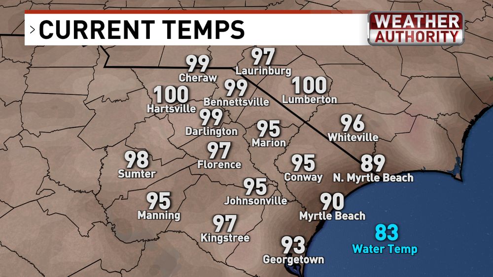
For the first time since last July, Lumberton has reached 100 degrees Fahrenheit. Also reaching 100 degrees is Hartsville. Current temps as of 3:30pm Tuesday... and heat index values to show what it actually feels like outside with the humidity
Hydrate up and stay cool out there, folks!
Hydrate up and stay cool out there, folks!

June 24, 2025 at 7:33 PM
For the first time since last July, Lumberton has reached 100 degrees Fahrenheit. Also reaching 100 degrees is Hartsville. Current temps as of 3:30pm Tuesday... and heat index values to show what it actually feels like outside with the humidity
Hydrate up and stay cool out there, folks!
Hydrate up and stay cool out there, folks!
A Thunderstorm Warning has been issued for Oklahoma City tonight!!!! Wow, what a series and what a Game 7… All I can say is #THUNDERUP ⚡️⚡️⚡️

June 23, 2025 at 3:13 AM
A Thunderstorm Warning has been issued for Oklahoma City tonight!!!! Wow, what a series and what a Game 7… All I can say is #THUNDERUP ⚡️⚡️⚡️