

Ensembleator
@ensembleator.bsky.social
Semi-retired meteorologist, living in lovely #YVR since 1994. I often write forecasts using abbreviations due to social media character limits. Dnt wry, U wll gt it.
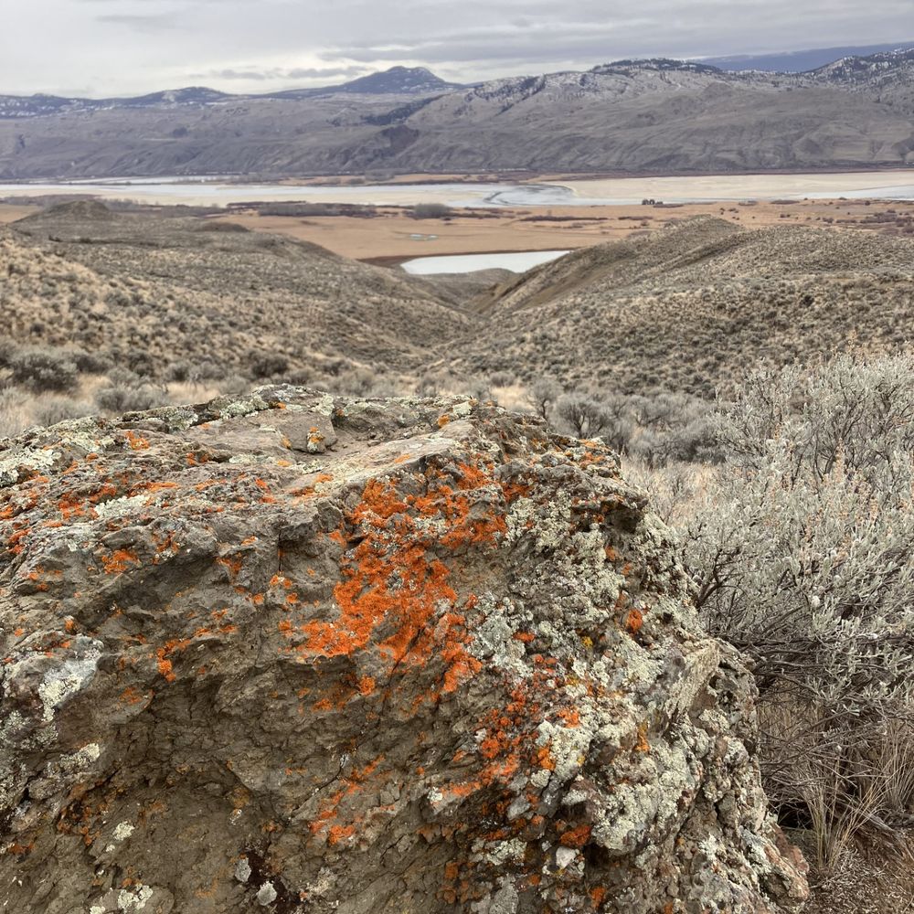
Fog below and cirrus uncinus above as a short lived ridge exits and the next upper trough approaches

November 9, 2025 at 8:49 AM
Fog below and cirrus uncinus above as a short lived ridge exits and the next upper trough approaches
Misty Irish country morning

November 9, 2025 at 8:18 AM
Misty Irish country morning
A damp hill walk in Ireland on a showery blustery day
November 7, 2025 at 9:39 PM
A damp hill walk in Ireland on a showery blustery day
Grey morning in Dublin

November 5, 2025 at 9:27 AM
Grey morning in Dublin
Areas of fog dvlpg inland this AM #YVR. Owz a mainly sunny AM. Clds increase PM. Rain dvlps ovnite, tapers to shwrs that continue thru the day on Wed. Windy from the SE. Vrbl skies chc shwrs Thu AM w/rain, wind PM. Vrbl skies Fri chc shwr. Wknd looking nice: dry, vrbl skies, coolish. Back on Mon :)
November 4, 2025 at 1:33 PM
Areas of fog dvlpg inland this AM #YVR. Owz a mainly sunny AM. Clds increase PM. Rain dvlps ovnite, tapers to shwrs that continue thru the day on Wed. Windy from the SE. Vrbl skies chc shwrs Thu AM w/rain, wind PM. Vrbl skies Fri chc shwr. Wknd looking nice: dry, vrbl skies, coolish. Back on Mon :)

A gaggle of trofs and minor circulations offshore tracking E-NE but they all miss #YVR. Clds tdy w/partial clrg ltr AM. Dvlpg upr sys 47N 158W digs ESE and spawns a more significant trof/fnt for Wed. Areas fog Tue AM then vrbl skies. Rain/wind Wed. Breezy/shwrs Thu endg Fri AM then dry thru Sun PM.
November 3, 2025 at 2:54 PM
A gaggle of trofs and minor circulations offshore tracking E-NE but they all miss #YVR. Clds tdy w/partial clrg ltr AM. Dvlpg upr sys 47N 158W digs ESE and spawns a more significant trof/fnt for Wed. Areas fog Tue AM then vrbl skies. Rain/wind Wed. Breezy/shwrs Thu endg Fri AM then dry thru Sun PM.
Busy w/forestry tdy. Dirty ridge over SWBC this PM w/weak lows NW and the SW + a jetstream ovhd #YVR. Ridge splits the lows but chc shwr ovnite. Mainly cldy Mon AM w/vrbl skies PM. Mix sun/cld Tue (ptchy AM fog). Rain Wed all day w/a brisk E wind. More rain/breezy Thu. Shwrs Fri. Sat looks dry
November 3, 2025 at 12:55 AM
Busy w/forestry tdy. Dirty ridge over SWBC this PM w/weak lows NW and the SW + a jetstream ovhd #YVR. Ridge splits the lows but chc shwr ovnite. Mainly cldy Mon AM w/vrbl skies PM. Mix sun/cld Tue (ptchy AM fog). Rain Wed all day w/a brisk E wind. More rain/breezy Thu. Shwrs Fri. Sat looks dry
A powerful jetstream has a lot to do with tdys windstorm. Mdls continue to deepen the low as it Xs over the coast range. The system has excellent support w/the jet promoting stg divergence aloft, thus lowering sfc P. In this pattn I would suspect power outages likely Vly esp. S of the Fraser.

November 1, 2025 at 3:02 PM
A powerful jetstream has a lot to do with tdys windstorm. Mdls continue to deepen the low as it Xs over the coast range. The system has excellent support w/the jet promoting stg divergence aloft, thus lowering sfc P. In this pattn I would suspect power outages likely Vly esp. S of the Fraser.
Deepng low to the W in the wake of ydy's short AR Xs SWBC this AM. It tracks inland just N of #YVR this AM: a windy pattern. Rain this AM. Brisk SE winds dvlp shortly (gust 50 beaches) and switch to WNW G60-70 beaches in the wake of the low. Winds diminish vrbl skies ltr PM. Mxd bag Sun w/chc shwr
November 1, 2025 at 1:57 PM
Deepng low to the W in the wake of ydy's short AR Xs SWBC this AM. It tracks inland just N of #YVR this AM: a windy pattern. Rain this AM. Brisk SE winds dvlp shortly (gust 50 beaches) and switch to WNW G60-70 beaches in the wake of the low. Winds diminish vrbl skies ltr PM. Mxd bag Sun w/chc shwr
Moisture rich fnt + trailing low (dvlpg now 41.5N 156W) Xs SWBC nxt 24h. Rain tdy, w/a brisk SE wnd, tapering to shwrs - w/a chc of a few dry hrs - this eve. Rain re-dvlps Sat AM, taprng to shwrs PM. Ttl #YVR rain 25-75 mm fm S-N. High rain rates will create lcl floods/road ponds this PM and Sat AM
October 31, 2025 at 1:58 PM
Moisture rich fnt + trailing low (dvlpg now 41.5N 156W) Xs SWBC nxt 24h. Rain tdy, w/a brisk SE wnd, tapering to shwrs - w/a chc of a few dry hrs - this eve. Rain re-dvlps Sat AM, taprng to shwrs PM. Ttl #YVR rain 25-75 mm fm S-N. High rain rates will create lcl floods/road ponds this PM and Sat AM
#YVR undr a moist SW flow w/a weak upr trof ofshr movng E. Vrbl skies tdy. Deep low 48.7N 155.5W lifts ENE, dragging a plume of subtrop air (an AR 1-2 inland) ovr SWBC Fri. AR ttl 25-50 mm, heaviest 2PM-6PM. Lcl flooding. Breezy. A pause ltr eve then more hvy rain w/the cold fnt Sat AM, tapers PM
October 30, 2025 at 1:42 PM
#YVR undr a moist SW flow w/a weak upr trof ofshr movng E. Vrbl skies tdy. Deep low 48.7N 155.5W lifts ENE, dragging a plume of subtrop air (an AR 1-2 inland) ovr SWBC Fri. AR ttl 25-50 mm, heaviest 2PM-6PM. Lcl flooding. Breezy. A pause ltr eve then more hvy rain w/the cold fnt Sat AM, tapers PM

Shwrs taper off this AM as a ridge blds onto the coast #YVR. Mainly cldy AM; some PM sun. Ptchy fog dvlps ovnite otwz a few clds Thu; dry. AR runs into SWBC Fri w/rain dvlpg AM tapering erly Sat AM. A sodden, breezy Halloween for the kids and kids at heart. Vrbl skies, dry Sat. Foggy/drizzly Sun AM
October 29, 2025 at 12:57 PM
Shwrs taper off this AM as a ridge blds onto the coast #YVR. Mainly cldy AM; some PM sun. Ptchy fog dvlps ovnite otwz a few clds Thu; dry. AR runs into SWBC Fri w/rain dvlpg AM tapering erly Sat AM. A sodden, breezy Halloween for the kids and kids at heart. Vrbl skies, dry Sat. Foggy/drizzly Sun AM
Slug of heavy rain will run thru #YVR over the next hour and a bit. Cold Front. Not a great time to walk the dog. Good thing I don't have one.
October 29, 2025 at 1:17 AM
Slug of heavy rain will run thru #YVR over the next hour and a bit. Cold Front. Not a great time to walk the dog. Good thing I don't have one.
Deep low nr 48N 139W tracking ENE, w/a warm fnt stretching to its E ovr SE WA, lifting N. Cold fnt trailing SSW. Rain/blustry SE wind dvlps this AM #YVR, tapering to shwrs Wed AM as the cold fnt sweeps inland. Some PM clrg. Vrbl skies/cool Thu. Rain/some wind Fri/Sat. Looks AR-ish. Dry/cool Sun.
October 28, 2025 at 1:17 PM
Deep low nr 48N 139W tracking ENE, w/a warm fnt stretching to its E ovr SE WA, lifting N. Cold fnt trailing SSW. Rain/blustry SE wind dvlps this AM #YVR, tapering to shwrs Wed AM as the cold fnt sweeps inland. Some PM clrg. Vrbl skies/cool Thu. Rain/some wind Fri/Sat. Looks AR-ish. Dry/cool Sun.
Devastating hurricane Melissa, eye filled with lightning and gravity waves propagating radially from the centre, about to wreak havoc on Jamaica today.
October 28, 2025 at 12:51 PM
Devastating hurricane Melissa, eye filled with lightning and gravity waves propagating radially from the centre, about to wreak havoc on Jamaica today.
#YVR undr a very cool Wly flow, unstbl at low lvls but stabilizing thru the day as a rdg bulds onshr. Mnly cldy, cool. Chc shwr this AM. Increasng cld ovnite as a warm fnt approaches fm the SW. Rain dvlpng Tue AM. Brisk E wind. Unsettled/shwrs Wed. AM fog, mainly sunny Thu w/outflow. Shwrs back Fri
October 27, 2025 at 1:51 PM
#YVR undr a very cool Wly flow, unstbl at low lvls but stabilizing thru the day as a rdg bulds onshr. Mnly cldy, cool. Chc shwr this AM. Increasng cld ovnite as a warm fnt approaches fm the SW. Rain dvlpng Tue AM. Brisk E wind. Unsettled/shwrs Wed. AM fog, mainly sunny Thu w/outflow. Shwrs back Fri
Bushfires in the wake of Sunday’s severe thunderstorms paint the sun red in Brisbane AU. Taken by my daughter.

October 27, 2025 at 12:49 PM
Bushfires in the wake of Sunday’s severe thunderstorms paint the sun red in Brisbane AU. Taken by my daughter.
Lightning in a severe thunderstorm that hit Brisbane last evening from my daughter’s coworker

October 27, 2025 at 3:32 AM
Lightning in a severe thunderstorm that hit Brisbane last evening from my daughter’s coworker
Diminishing winds, mainly cloudy, cool+ unsettled tdy #YVR w/some AM shwrs and mtn flurries/chc ⚡esp this PM. Vry cool aloft w/a building ridge at the sfc. Notice the jet stream now well to the S ovr Srn OR. Vrbl skies/chc sprinkles ovnite and Mon and quite cool. Cld, shwrs dvlpg Tue, rain/wind late
October 26, 2025 at 1:19 PM
Diminishing winds, mainly cloudy, cool+ unsettled tdy #YVR w/some AM shwrs and mtn flurries/chc ⚡esp this PM. Vry cool aloft w/a building ridge at the sfc. Notice the jet stream now well to the S ovr Srn OR. Vrbl skies/chc sprinkles ovnite and Mon and quite cool. Cld, shwrs dvlpg Tue, rain/wind late
Vertically stacked upr/sfc low near 48.7N 130W (clear centre) and a shallow/convective near-surface system tracking rapidly E near 44.5N 129W. It's the main system further N that's going to give us some wind (likely power) issues tonight #YVR / Fraser Valley
October 25, 2025 at 5:06 PM
Vertically stacked upr/sfc low near 48.7N 130W (clear centre) and a shallow/convective near-surface system tracking rapidly E near 44.5N 129W. It's the main system further N that's going to give us some wind (likely power) issues tonight #YVR / Fraser Valley
Convective upr/sfc low offshore moves ENE, Xing central VI this eve: a windy pattn. Shwrs + brisk E winds dvlp this AM #YVR, bcmg vry brisk SWlys ltr this eve (G 60's beach) as the low tracks inland to the N. Cool w/vrbl skes Sun. Mtn shwrs/flurries chc ⚡. Unsettled Mon, cool. Vry cool Tue AM, dry.
October 25, 2025 at 1:34 PM
Convective upr/sfc low offshore moves ENE, Xing central VI this eve: a windy pattn. Shwrs + brisk E winds dvlp this AM #YVR, bcmg vry brisk SWlys ltr this eve (G 60's beach) as the low tracks inland to the N. Cool w/vrbl skes Sun. Mtn shwrs/flurries chc ⚡. Unsettled Mon, cool. Vry cool Tue AM, dry.
A little vortmax spinning up offshore in jetstream-induced shear (blue-orange couplet) may bring some brief heavy showers this eve #YVR with a slight chc of ⚡
October 24, 2025 at 11:50 PM
A little vortmax spinning up offshore in jetstream-induced shear (blue-orange couplet) may bring some brief heavy showers this eve #YVR with a slight chc of ⚡
This is an instantaneous sfc pressure change product for later Sat eve. Colours trending to deeper greens are stronger pressure increases. Warm colours are pressure falls. This pattern is consistent with a Juan de Fuca windstorm Sat eve, w/strong SW winds in #YVR and strong inflows thru Howe Sound

October 24, 2025 at 4:53 PM
This is an instantaneous sfc pressure change product for later Sat eve. Colours trending to deeper greens are stronger pressure increases. Warm colours are pressure falls. This pattern is consistent with a Juan de Fuca windstorm Sat eve, w/strong SW winds in #YVR and strong inflows thru Howe Sound