


Vicky Veritas
@vickyveritas.bsky.social
Born in the Anthropocene
Worked at the intersection of Geology and GIS
#Geosciences | #EarthScience | #Geology | #GIS | #Rocks | #TeamFluorite | #ScienceFiction | #Fantasy
Worked at the intersection of Geology and GIS
#Geosciences | #EarthScience | #Geology | #GIS | #Rocks | #TeamFluorite | #ScienceFiction | #Fantasy
Reposted by Vicky Veritas
Here’s a nice Saturday Surprise. I just posted 19 new volcano tissue box covers in my Etsy shop. They are 3D printed scale models made using lidar scans from federally funded USGS projects and my photogrammetry. Thanks to @opentopography.org for organizing the data!
phaneritic.etsy.com
phaneritic.etsy.com


January 31, 2026 at 8:46 PM
Here’s a nice Saturday Surprise. I just posted 19 new volcano tissue box covers in my Etsy shop. They are 3D printed scale models made using lidar scans from federally funded USGS projects and my photogrammetry. Thanks to @opentopography.org for organizing the data!
phaneritic.etsy.com
phaneritic.etsy.com
Reposted by Vicky Veritas
Nevermind the jobs you had, tell me five classes you took in college:
Sedimentology and Stratigraphy ♥️♥️♥️
American Environmental History 📜
Field Drawing 🎨
Ecosystems Ecology 🌿
Spanish Coffee and News 🗞️
History prof had a burning personal vendetta against the Glen Canyon Dam.
Sedimentology and Stratigraphy ♥️♥️♥️
American Environmental History 📜
Field Drawing 🎨
Ecosystems Ecology 🌿
Spanish Coffee and News 🗞️
History prof had a burning personal vendetta against the Glen Canyon Dam.
Nevermind the jobs you had, tell me five classes you took in college:
Comic Fiction
Seminar in World Music (learned to play music from Indonesia and Ghana, got into ethnomusicology)
Italian
Intro to Philosophy
Artificial Intelligence /ducks
Comic Fiction
Seminar in World Music (learned to play music from Indonesia and Ghana, got into ethnomusicology)
Italian
Intro to Philosophy
Artificial Intelligence /ducks
Nevermind the jobs you had, tell me five classes you took in college:
Intro to Ordinary Differential Equations
Digital Design
Modern Physics
Electronics Lab
Choral Conducting
Intro to Ordinary Differential Equations
Digital Design
Modern Physics
Electronics Lab
Choral Conducting
January 31, 2026 at 2:14 PM
Nevermind the jobs you had, tell me five classes you took in college:
Sedimentology and Stratigraphy ♥️♥️♥️
American Environmental History 📜
Field Drawing 🎨
Ecosystems Ecology 🌿
Spanish Coffee and News 🗞️
History prof had a burning personal vendetta against the Glen Canyon Dam.
Sedimentology and Stratigraphy ♥️♥️♥️
American Environmental History 📜
Field Drawing 🎨
Ecosystems Ecology 🌿
Spanish Coffee and News 🗞️
History prof had a burning personal vendetta against the Glen Canyon Dam.
Reposted by Vicky Veritas
Nevermind the jobs you had, tell me five classes you took in college: (round 2)
•Ethics of the Life Cycle
•Environmental Geology
•Modern Ballet for Non-Majors
•Documentary Film
•Shakespeare
•Ethics of the Life Cycle
•Environmental Geology
•Modern Ballet for Non-Majors
•Documentary Film
•Shakespeare
Nevermind the jobs you had, tell me five classes you took in college:
Linear Algebra
Nuclear Physics (don’t ask)
Engineering Geology
Optical Mineralogy
Field Geology
Linear Algebra
Nuclear Physics (don’t ask)
Engineering Geology
Optical Mineralogy
Field Geology
Nevermind the jobs you had, tell me five classes you took in college:
Sedimentology and Stratigraphy ♥️♥️♥️
American Environmental History 📜
Field Drawing 🎨
Ecosystems Ecology 🌿
Spanish Coffee and News 🗞️
History prof had a burning personal vendetta against the Glen Canyon Dam.
Sedimentology and Stratigraphy ♥️♥️♥️
American Environmental History 📜
Field Drawing 🎨
Ecosystems Ecology 🌿
Spanish Coffee and News 🗞️
History prof had a burning personal vendetta against the Glen Canyon Dam.
January 31, 2026 at 9:05 PM
Nevermind the jobs you had, tell me five classes you took in college: (round 2)
•Ethics of the Life Cycle
•Environmental Geology
•Modern Ballet for Non-Majors
•Documentary Film
•Shakespeare
•Ethics of the Life Cycle
•Environmental Geology
•Modern Ballet for Non-Majors
•Documentary Film
•Shakespeare
Reposted by Vicky Veritas

Free workshop alert! Bring a pencil! 😉 (but don't worry, no drawing ability required to take part)
Register here: forms.office.com/pages/respon...
Register here: forms.office.com/pages/respon...

January 19, 2026 at 8:12 PM
Free workshop alert! Bring a pencil! 😉 (but don't worry, no drawing ability required to take part)
Register here: forms.office.com/pages/respon...
Register here: forms.office.com/pages/respon...
Reposted by Vicky Veritas
Happening today (3 PM US eastern)! There's still time to register. ⚒️🧪
Want to learn more about NISAR (the new joint India/US synthetic aperture radar satellite mission)? Franz Meyer from UAF/Alaska Satellite Facility will be giving an online talk to introduce NISAR and its capabilities on Jan. 21. More info and registration below. ⚒️🧪
uaf-accap.org/event/vaws-i...
uaf-accap.org/event/vaws-i...

VAWS – Introducing NISAR: NASA’s Biggest Earth Observation Mission | ACCAP
Speaker: Franz Meyer, Professor, UAF Geophysical Institute, Chief Scientist, Alaska Satellite Facility About the webinar: Some of the recent earthquakes in Alaska and across the globe showed us how…
uaf-accap.org
January 21, 2026 at 5:26 PM
Happening today (3 PM US eastern)! There's still time to register. ⚒️🧪
Reposted by Vicky Veritas
Nevermind the jobs you had, tell me five classes you took in college:
Electricity and Magnetism (favorite physics class)
18th Century French Literature (in French)
Linear Algebra
Hellenistic World and Roman Empire
Rock Climbing
Electricity and Magnetism (favorite physics class)
18th Century French Literature (in French)
Linear Algebra
Hellenistic World and Roman Empire
Rock Climbing
Nevermind the jobs you had, tell me five classes you took in college:
Sedimentology and Stratigraphy ♥️♥️♥️
American Environmental History 📜
Field Drawing 🎨
Ecosystems Ecology 🌿
Spanish Coffee and News 🗞️
History prof had a burning personal vendetta against the Glen Canyon Dam.
Sedimentology and Stratigraphy ♥️♥️♥️
American Environmental History 📜
Field Drawing 🎨
Ecosystems Ecology 🌿
Spanish Coffee and News 🗞️
History prof had a burning personal vendetta against the Glen Canyon Dam.
Nevermind the jobs you had, tell me five classes you took in college:
Comic Fiction
Seminar in World Music (learned to play music from Indonesia and Ghana, got into ethnomusicology)
Italian
Intro to Philosophy
Artificial Intelligence /ducks
Comic Fiction
Seminar in World Music (learned to play music from Indonesia and Ghana, got into ethnomusicology)
Italian
Intro to Philosophy
Artificial Intelligence /ducks
January 31, 2026 at 3:01 PM
Nevermind the jobs you had, tell me five classes you took in college:
Electricity and Magnetism (favorite physics class)
18th Century French Literature (in French)
Linear Algebra
Hellenistic World and Roman Empire
Rock Climbing
Electricity and Magnetism (favorite physics class)
18th Century French Literature (in French)
Linear Algebra
Hellenistic World and Roman Empire
Rock Climbing
Reposted by Vicky Veritas

Nevermind the jobs you had, tell me five classes you took in college:
Cartography
Photojournalism
20th Century German Literature
Philosophy of Evolution
Orienteering
Interesting that although I enjoyed being a geology major, geology courses weren't among those that immediately came to mind.
Cartography
Photojournalism
20th Century German Literature
Philosophy of Evolution
Orienteering
Interesting that although I enjoyed being a geology major, geology courses weren't among those that immediately came to mind.
Nevermind the jobs you had, tell me five classes you took in college:
Linear Algebra
Nuclear Physics (don’t ask)
Engineering Geology
Optical Mineralogy
Field Geology
Linear Algebra
Nuclear Physics (don’t ask)
Engineering Geology
Optical Mineralogy
Field Geology
Nevermind the jobs you had, tell me five classes you took in college:
Sedimentology and Stratigraphy ♥️♥️♥️
American Environmental History 📜
Field Drawing 🎨
Ecosystems Ecology 🌿
Spanish Coffee and News 🗞️
History prof had a burning personal vendetta against the Glen Canyon Dam.
Sedimentology and Stratigraphy ♥️♥️♥️
American Environmental History 📜
Field Drawing 🎨
Ecosystems Ecology 🌿
Spanish Coffee and News 🗞️
History prof had a burning personal vendetta against the Glen Canyon Dam.
January 31, 2026 at 8:38 PM
Nevermind the jobs you had, tell me five classes you took in college:
Cartography
Photojournalism
20th Century German Literature
Philosophy of Evolution
Orienteering
Interesting that although I enjoyed being a geology major, geology courses weren't among those that immediately came to mind.
Cartography
Photojournalism
20th Century German Literature
Philosophy of Evolution
Orienteering
Interesting that although I enjoyed being a geology major, geology courses weren't among those that immediately came to mind.
Reposted by Vicky Veritas
Nevermind the jobs you had, tell me five classes you took in college:
Environmental Field Studies
Tectonostratigraphic Evolution of the San Francisco Bay Area
Field Geology
Historical Geography of North America
Outdoor Adventure Recreation
Environmental Field Studies
Tectonostratigraphic Evolution of the San Francisco Bay Area
Field Geology
Historical Geography of North America
Outdoor Adventure Recreation
Nevermind the jobs you had, tell me five classes you took in college:
Linear Algebra
Nuclear Physics (don’t ask)
Engineering Geology
Optical Mineralogy
Field Geology
Linear Algebra
Nuclear Physics (don’t ask)
Engineering Geology
Optical Mineralogy
Field Geology
Nevermind the jobs you had, tell me five classes you took in college:
Sedimentology and Stratigraphy ♥️♥️♥️
American Environmental History 📜
Field Drawing 🎨
Ecosystems Ecology 🌿
Spanish Coffee and News 🗞️
History prof had a burning personal vendetta against the Glen Canyon Dam.
Sedimentology and Stratigraphy ♥️♥️♥️
American Environmental History 📜
Field Drawing 🎨
Ecosystems Ecology 🌿
Spanish Coffee and News 🗞️
History prof had a burning personal vendetta against the Glen Canyon Dam.
January 31, 2026 at 8:34 PM
Nevermind the jobs you had, tell me five classes you took in college:
Environmental Field Studies
Tectonostratigraphic Evolution of the San Francisco Bay Area
Field Geology
Historical Geography of North America
Outdoor Adventure Recreation
Environmental Field Studies
Tectonostratigraphic Evolution of the San Francisco Bay Area
Field Geology
Historical Geography of North America
Outdoor Adventure Recreation
Reposted by Vicky Veritas
🧪⚒️
New story in @science.org. Evidence for two huge Triassic supereruptions found on Tibetan Plateau. 🧪#geology

Traces of ancient seafloor cataclysms turn up in the Himalayas
Vast undersea eruptions may be undercounted source of extinctions through Earth’s history
www.science.org
January 31, 2026 at 4:48 PM
🧪⚒️
Reposted by Vicky Veritas
Tell me five classes you took in college:
Ancient & Imperial Russia
Archeological Geology
Prehistory of North America
Volcanology
Evolution
Look, despite spending my career extolling the importance of a liberal arts education, I really just mainlined field trips, Earth and life sciences.
Ancient & Imperial Russia
Archeological Geology
Prehistory of North America
Volcanology
Evolution
Look, despite spending my career extolling the importance of a liberal arts education, I really just mainlined field trips, Earth and life sciences.
Macroevolution
Astrophysics
Music performance (violin)
Computational statistics
British poetry
This is an interesting list considering I was a geology major lol
Astrophysics
Music performance (violin)
Computational statistics
British poetry
This is an interesting list considering I was a geology major lol
Tell me five classes you took in college:
Medieval drama
Nuclear Ethics
Michelangelo
Coalescence
Phylogenetic Methods
Medieval drama
Nuclear Ethics
Michelangelo
Coalescence
Phylogenetic Methods
January 31, 2026 at 4:56 PM
Tell me five classes you took in college:
Ancient & Imperial Russia
Archeological Geology
Prehistory of North America
Volcanology
Evolution
Look, despite spending my career extolling the importance of a liberal arts education, I really just mainlined field trips, Earth and life sciences.
Ancient & Imperial Russia
Archeological Geology
Prehistory of North America
Volcanology
Evolution
Look, despite spending my career extolling the importance of a liberal arts education, I really just mainlined field trips, Earth and life sciences.
Reposted by Vicky Veritas
⚒️🧪Fiery Mud Volcano Eruption!
The Daşmərdan (Dashmardan) mud volcano in Azerbaijan erupted ~16:50 on the 30th Jan 2026. The eruption lasted ~15 mins and was accompanied by a pillar of flame several hundred meters high. Daşmərdan had previous documented eruptions in 1866, 1954, 1976, 1986 and 2011.
The Daşmərdan (Dashmardan) mud volcano in Azerbaijan erupted ~16:50 on the 30th Jan 2026. The eruption lasted ~15 mins and was accompanied by a pillar of flame several hundred meters high. Daşmərdan had previous documented eruptions in 1866, 1954, 1976, 1986 and 2011.
January 31, 2026 at 2:07 PM
⚒️🧪Fiery Mud Volcano Eruption!
The Daşmərdan (Dashmardan) mud volcano in Azerbaijan erupted ~16:50 on the 30th Jan 2026. The eruption lasted ~15 mins and was accompanied by a pillar of flame several hundred meters high. Daşmərdan had previous documented eruptions in 1866, 1954, 1976, 1986 and 2011.
The Daşmərdan (Dashmardan) mud volcano in Azerbaijan erupted ~16:50 on the 30th Jan 2026. The eruption lasted ~15 mins and was accompanied by a pillar of flame several hundred meters high. Daşmərdan had previous documented eruptions in 1866, 1954, 1976, 1986 and 2011.
Reposted by Vicky Veritas
Nevermind the jobs you had, tell me five classes you took in college:
Physical Chemistry
Theater
Environmental geophysics
Oceanography
Invertebrate Paleobiology
Physical Chemistry
Theater
Environmental geophysics
Oceanography
Invertebrate Paleobiology
Nevermind the jobs you had, tell me five classes you took in college:
Linear Algebra
Nuclear Physics (don’t ask)
Engineering Geology
Optical Mineralogy
Field Geology
Linear Algebra
Nuclear Physics (don’t ask)
Engineering Geology
Optical Mineralogy
Field Geology
Nevermind the jobs you had, tell me five classes you took in college:
Sedimentology and Stratigraphy ♥️♥️♥️
American Environmental History 📜
Field Drawing 🎨
Ecosystems Ecology 🌿
Spanish Coffee and News 🗞️
History prof had a burning personal vendetta against the Glen Canyon Dam.
Sedimentology and Stratigraphy ♥️♥️♥️
American Environmental History 📜
Field Drawing 🎨
Ecosystems Ecology 🌿
Spanish Coffee and News 🗞️
History prof had a burning personal vendetta against the Glen Canyon Dam.
January 31, 2026 at 5:53 PM
Nevermind the jobs you had, tell me five classes you took in college:
Physical Chemistry
Theater
Environmental geophysics
Oceanography
Invertebrate Paleobiology
Physical Chemistry
Theater
Environmental geophysics
Oceanography
Invertebrate Paleobiology
Reposted by Vicky Veritas
Nevermind the jobs you had, tell me five classes you took in college.
Economic Development in Latin America
Soil Science
Postmodernism in Literature
Tropical Agriculture Systems
Civilization and Capitalism 15th - 18th Century
Economic Development in Latin America
Soil Science
Postmodernism in Literature
Tropical Agriculture Systems
Civilization and Capitalism 15th - 18th Century
Nevermind the jobs you had, tell me five classes you took in college:
Linear Algebra
Nuclear Physics (don’t ask)
Engineering Geology
Optical Mineralogy
Field Geology
Linear Algebra
Nuclear Physics (don’t ask)
Engineering Geology
Optical Mineralogy
Field Geology
Nevermind the jobs you had, tell me five classes you took in college:
Sedimentology and Stratigraphy ♥️♥️♥️
American Environmental History 📜
Field Drawing 🎨
Ecosystems Ecology 🌿
Spanish Coffee and News 🗞️
History prof had a burning personal vendetta against the Glen Canyon Dam.
Sedimentology and Stratigraphy ♥️♥️♥️
American Environmental History 📜
Field Drawing 🎨
Ecosystems Ecology 🌿
Spanish Coffee and News 🗞️
History prof had a burning personal vendetta against the Glen Canyon Dam.
January 31, 2026 at 5:20 PM
Nevermind the jobs you had, tell me five classes you took in college.
Economic Development in Latin America
Soil Science
Postmodernism in Literature
Tropical Agriculture Systems
Civilization and Capitalism 15th - 18th Century
Economic Development in Latin America
Soil Science
Postmodernism in Literature
Tropical Agriculture Systems
Civilization and Capitalism 15th - 18th Century
Reposted by Vicky Veritas

Advertising
Intercultural Communications
History of Graphic Design
Photography
History of Middle Earth
Intercultural Communications
History of Graphic Design
Photography
History of Middle Earth
Nevermind the jobs you had, tell me five classes you took in college:
Linear Algebra
Nuclear Physics (don’t ask)
Engineering Geology
Optical Mineralogy
Field Geology
Linear Algebra
Nuclear Physics (don’t ask)
Engineering Geology
Optical Mineralogy
Field Geology
Nevermind the jobs you had, tell me five classes you took in college:
Sedimentology and Stratigraphy ♥️♥️♥️
American Environmental History 📜
Field Drawing 🎨
Ecosystems Ecology 🌿
Spanish Coffee and News 🗞️
History prof had a burning personal vendetta against the Glen Canyon Dam.
Sedimentology and Stratigraphy ♥️♥️♥️
American Environmental History 📜
Field Drawing 🎨
Ecosystems Ecology 🌿
Spanish Coffee and News 🗞️
History prof had a burning personal vendetta against the Glen Canyon Dam.
January 31, 2026 at 5:21 PM
Advertising
Intercultural Communications
History of Graphic Design
Photography
History of Middle Earth
Intercultural Communications
History of Graphic Design
Photography
History of Middle Earth
Reposted by Vicky Veritas

Of course, I could've answered Paleobioecogeochemosedimentichnology
Macroevolution
Astrophysics
Music performance (violin)
Computational statistics
British poetry
This is an interesting list considering I was a geology major lol
Astrophysics
Music performance (violin)
Computational statistics
British poetry
This is an interesting list considering I was a geology major lol
Tell me five classes you took in college:
Medieval drama
Nuclear Ethics
Michelangelo
Coalescence
Phylogenetic Methods
Medieval drama
Nuclear Ethics
Michelangelo
Coalescence
Phylogenetic Methods
January 31, 2026 at 4:48 PM
Of course, I could've answered Paleobioecogeochemosedimentichnology
Reposted by Vicky Veritas
Nevermind the jobs you had, tell me five classes you took in college:
Archery & Bowling
Universal Stage Optical Mineralogy
General Relativity
Advanced Mineralogy
Introduction to Geophysics
Archery & Bowling
Universal Stage Optical Mineralogy
General Relativity
Advanced Mineralogy
Introduction to Geophysics
Nevermind the jobs you had, tell me five classes you took in college:
Linear Algebra
Nuclear Physics (don’t ask)
Engineering Geology
Optical Mineralogy
Field Geology
Linear Algebra
Nuclear Physics (don’t ask)
Engineering Geology
Optical Mineralogy
Field Geology
Nevermind the jobs you had, tell me five classes you took in college:
Sedimentology and Stratigraphy ♥️♥️♥️
American Environmental History 📜
Field Drawing 🎨
Ecosystems Ecology 🌿
Spanish Coffee and News 🗞️
History prof had a burning personal vendetta against the Glen Canyon Dam.
Sedimentology and Stratigraphy ♥️♥️♥️
American Environmental History 📜
Field Drawing 🎨
Ecosystems Ecology 🌿
Spanish Coffee and News 🗞️
History prof had a burning personal vendetta against the Glen Canyon Dam.
January 31, 2026 at 4:47 PM
Nevermind the jobs you had, tell me five classes you took in college:
Archery & Bowling
Universal Stage Optical Mineralogy
General Relativity
Advanced Mineralogy
Introduction to Geophysics
Archery & Bowling
Universal Stage Optical Mineralogy
General Relativity
Advanced Mineralogy
Introduction to Geophysics
Reposted by Vicky Veritas
Nevermind the jobs you had, tell me five classes you took in college:
Intro to Particle Physics
Deciphering Ancient Egypt (2 Semester)
Sun Dance People
Old Norse Literature in Translation
Books: Technology and Culture
Intro to Particle Physics
Deciphering Ancient Egypt (2 Semester)
Sun Dance People
Old Norse Literature in Translation
Books: Technology and Culture
Nevermind the jobs you had, tell me five classes you took in college:
Linear Algebra
Nuclear Physics (don’t ask)
Engineering Geology
Optical Mineralogy
Field Geology
Linear Algebra
Nuclear Physics (don’t ask)
Engineering Geology
Optical Mineralogy
Field Geology
Nevermind the jobs you had, tell me five classes you took in college:
Sedimentology and Stratigraphy ♥️♥️♥️
American Environmental History 📜
Field Drawing 🎨
Ecosystems Ecology 🌿
Spanish Coffee and News 🗞️
History prof had a burning personal vendetta against the Glen Canyon Dam.
Sedimentology and Stratigraphy ♥️♥️♥️
American Environmental History 📜
Field Drawing 🎨
Ecosystems Ecology 🌿
Spanish Coffee and News 🗞️
History prof had a burning personal vendetta against the Glen Canyon Dam.
January 31, 2026 at 4:54 PM
Nevermind the jobs you had, tell me five classes you took in college:
Intro to Particle Physics
Deciphering Ancient Egypt (2 Semester)
Sun Dance People
Old Norse Literature in Translation
Books: Technology and Culture
Intro to Particle Physics
Deciphering Ancient Egypt (2 Semester)
Sun Dance People
Old Norse Literature in Translation
Books: Technology and Culture
Nevermind the jobs you had, tell me five classes you took in college:
Linear Algebra
Nuclear Physics (don’t ask)
Engineering Geology
Optical Mineralogy
Field Geology
Linear Algebra
Nuclear Physics (don’t ask)
Engineering Geology
Optical Mineralogy
Field Geology
Nevermind the jobs you had, tell me five classes you took in college:
Sedimentology and Stratigraphy ♥️♥️♥️
American Environmental History 📜
Field Drawing 🎨
Ecosystems Ecology 🌿
Spanish Coffee and News 🗞️
History prof had a burning personal vendetta against the Glen Canyon Dam.
Sedimentology and Stratigraphy ♥️♥️♥️
American Environmental History 📜
Field Drawing 🎨
Ecosystems Ecology 🌿
Spanish Coffee and News 🗞️
History prof had a burning personal vendetta against the Glen Canyon Dam.
Nevermind the jobs you had, tell me five classes you took in college:
Comic Fiction
Seminar in World Music (learned to play music from Indonesia and Ghana, got into ethnomusicology)
Italian
Intro to Philosophy
Artificial Intelligence /ducks
Comic Fiction
Seminar in World Music (learned to play music from Indonesia and Ghana, got into ethnomusicology)
Italian
Intro to Philosophy
Artificial Intelligence /ducks
January 31, 2026 at 4:35 PM
Nevermind the jobs you had, tell me five classes you took in college:
Linear Algebra
Nuclear Physics (don’t ask)
Engineering Geology
Optical Mineralogy
Field Geology
Linear Algebra
Nuclear Physics (don’t ask)
Engineering Geology
Optical Mineralogy
Field Geology
Reposted by Vicky Veritas
Nevermind the jobs you had, tell me five classes you took in college:
Art History 🖼️
Philosophy 🤔
Comparative Religion ☯️
Mineralogy ⚒️
History of Jazz 🎺
All of these at a Junior College. Such a great place to expand your world!
Art History 🖼️
Philosophy 🤔
Comparative Religion ☯️
Mineralogy ⚒️
History of Jazz 🎺
All of these at a Junior College. Such a great place to expand your world!
Nevermind the jobs you had, tell me five classes you took in college:
Sedimentology and Stratigraphy ♥️♥️♥️
American Environmental History 📜
Field Drawing 🎨
Ecosystems Ecology 🌿
Spanish Coffee and News 🗞️
History prof had a burning personal vendetta against the Glen Canyon Dam.
Sedimentology and Stratigraphy ♥️♥️♥️
American Environmental History 📜
Field Drawing 🎨
Ecosystems Ecology 🌿
Spanish Coffee and News 🗞️
History prof had a burning personal vendetta against the Glen Canyon Dam.
Nevermind the jobs you had, tell me five classes you took in college:
Comic Fiction
Seminar in World Music (learned to play music from Indonesia and Ghana, got into ethnomusicology)
Italian
Intro to Philosophy
Artificial Intelligence /ducks
Comic Fiction
Seminar in World Music (learned to play music from Indonesia and Ghana, got into ethnomusicology)
Italian
Intro to Philosophy
Artificial Intelligence /ducks
January 31, 2026 at 4:17 PM
Nevermind the jobs you had, tell me five classes you took in college:
Art History 🖼️
Philosophy 🤔
Comparative Religion ☯️
Mineralogy ⚒️
History of Jazz 🎺
All of these at a Junior College. Such a great place to expand your world!
Art History 🖼️
Philosophy 🤔
Comparative Religion ☯️
Mineralogy ⚒️
History of Jazz 🎺
All of these at a Junior College. Such a great place to expand your world!
Reposted by Vicky Veritas
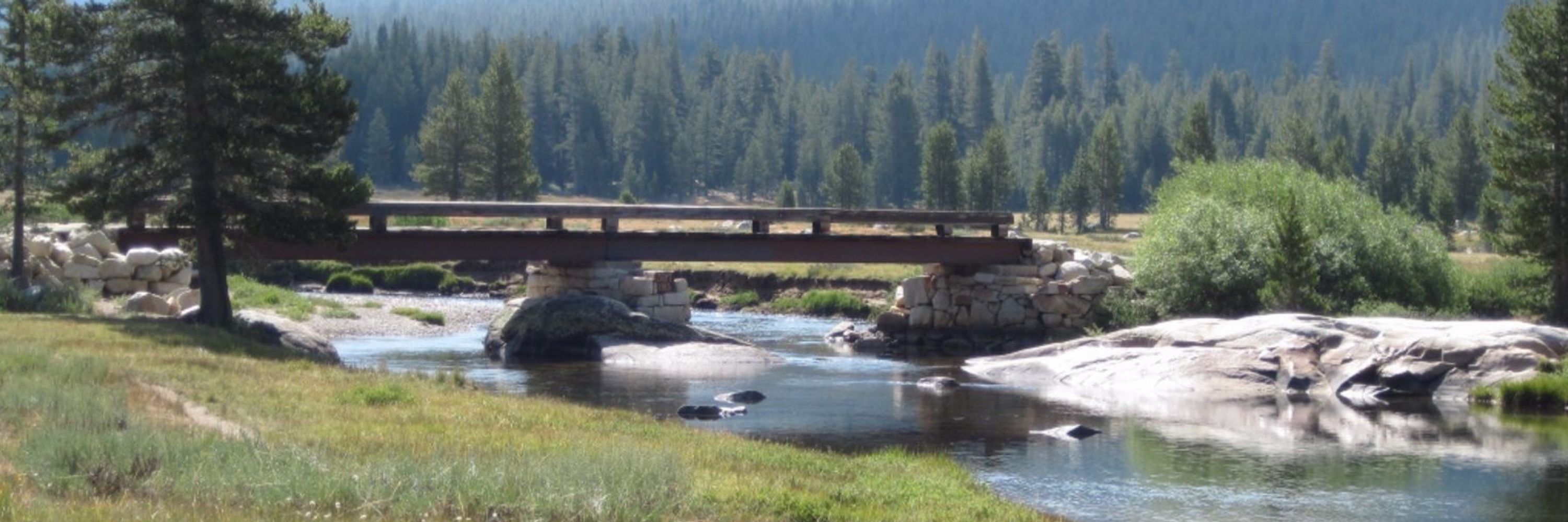
My final #FridayFold from December's visit to Mosaic Canyon in Death Valley NP in California. This one is pretty crazy, with at least two hinges. See if you can make any sense of it. ⚒️

January 30, 2026 at 5:49 PM
My final #FridayFold from December's visit to Mosaic Canyon in Death Valley NP in California. This one is pretty crazy, with at least two hinges. See if you can make any sense of it. ⚒️
Reposted by Vicky Veritas

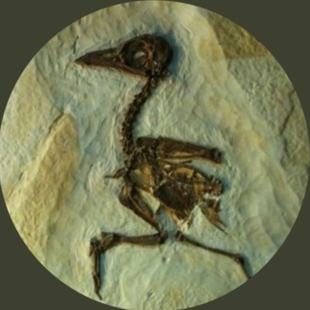
#FossilFriday Hildegarde Howard, American pioneer in avian paleontology, known for her discoveries in the La Brea Tar Pits, among them the Rancho La Brea eagles #FeministFriday 🧪⚒️
paleonerdish.wordpress.com/2019/05/01/f...
paleonerdish.wordpress.com/2019/05/01/f...


January 30, 2026 at 8:02 PM
#FossilFriday Hildegarde Howard, American pioneer in avian paleontology, known for her discoveries in the La Brea Tar Pits, among them the Rancho La Brea eagles #FeministFriday 🧪⚒️
paleonerdish.wordpress.com/2019/05/01/f...
paleonerdish.wordpress.com/2019/05/01/f...
Reposted by Vicky Veritas

January 30, 2026 at 8:11 PM
Reposted by Vicky Veritas
I am so humbled and forever thankful to my colleagues all over the country who have helped me with historical geology resources and so much help! We gotta be the closest net discipline out there. Special shout out to @callanbentley.bsky.social for always coming through!
January 30, 2026 at 8:28 PM
I am so humbled and forever thankful to my colleagues all over the country who have helped me with historical geology resources and so much help! We gotta be the closest net discipline out there. Special shout out to @callanbentley.bsky.social for always coming through!
Reposted by Vicky Veritas

😍😍😍😍😍😍 STUNNING displacement map of the Niscemi landslide in Italy using @planet.com superdove imagery🧪⚒️

January 30, 2026 at 8:55 PM
😍😍😍😍😍😍 STUNNING displacement map of the Niscemi landslide in Italy using @planet.com superdove imagery🧪⚒️
Reposted by Vicky Veritas
A late #FossilFriday A close up of the attachment structures from the mid-proterozoic #fossils I showed the other day. The fossils don't just sit on each other, they have a complex and consistent interweaving and inter looping pattern. See alt text for details #Geology #Paleontology

January 30, 2026 at 10:54 PM
A late #FossilFriday A close up of the attachment structures from the mid-proterozoic #fossils I showed the other day. The fossils don't just sit on each other, they have a complex and consistent interweaving and inter looping pattern. See alt text for details #Geology #Paleontology