


Rhodes Cartography
@thinkinginspace.bsky.social
Maps, mapping, geoviz. No politics.
Fellow @RGS_IBG
Board member @wmsmapsociety
Adjunct Professor @georgetownsfs
www.thinkinginspace.net
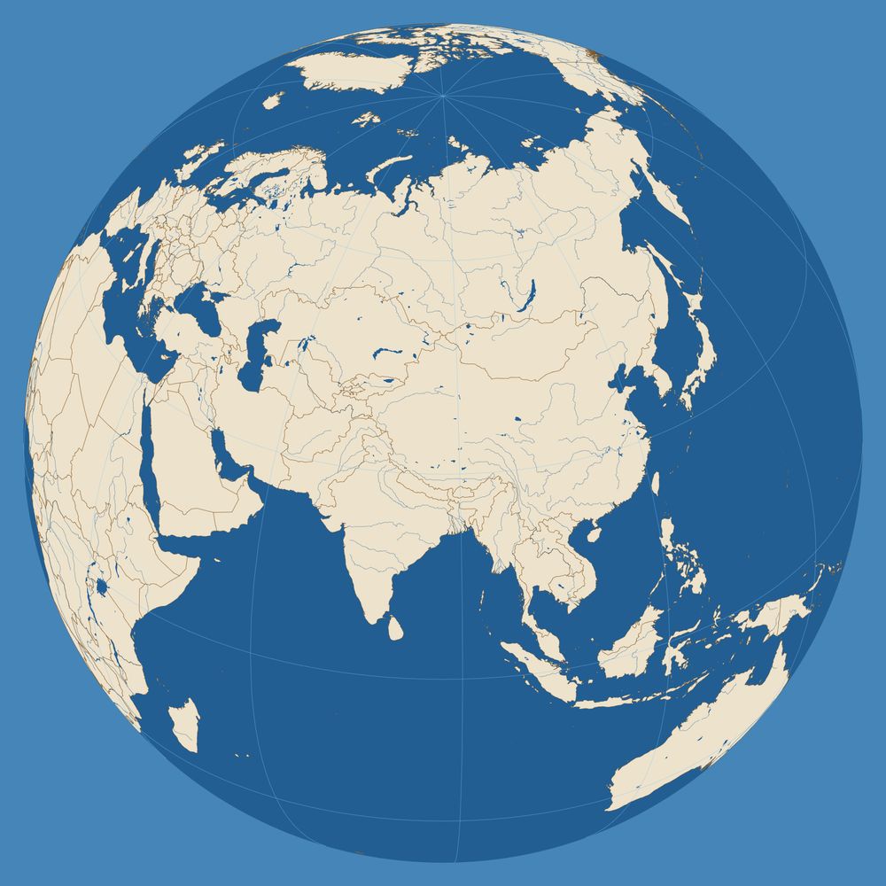
Simple Orthographic Map Creator with MetBrewer colors:
https://www.mapspam.net/MetOrtho.html
Fellow @RGS_IBG
Board member @wmsmapsociety
Adjunct Professor @georgetownsfs
www.thinkinginspace.net
Simple Orthographic Map Creator with MetBrewer colors:
https://www.mapspam.net/MetOrtho.html
Pinned

Spheres of Influence: Projecting Power & Fear onto the Globe
April 2nd - September 19th 2025 at the David Rumsey Map Center
storymaps.arcgis.com
Excited to have one of my maps featured in the new Rumsey Map Center exhibition "Spheres of Influence" at Stanford. Please visit if you are in NorCal, but you can also see the digital exhibit here:
storymaps.arcgis.com/stories/83a4...
storymaps.arcgis.com/stories/83a4...
Geography questions from the 1858 Oxford Local Examinations. How would you do?
I have been looking everywhere but have not yet found surviving examples of any "accompanying map" actually used in an exam. There was a whole industry around publishing exam prep maps.
I have been looking everywhere but have not yet found surviving examples of any "accompanying map" actually used in an exam. There was a whole industry around publishing exam prep maps.

December 6, 2025 at 3:56 PM
Geography questions from the 1858 Oxford Local Examinations. How would you do?
I have been looking everywhere but have not yet found surviving examples of any "accompanying map" actually used in an exam. There was a whole industry around publishing exam prep maps.
I have been looking everywhere but have not yet found surviving examples of any "accompanying map" actually used in an exam. There was a whole industry around publishing exam prep maps.
Reposted by Rhodes Cartography

#30daymapchallenge | Day 22 Data: Natural Earth | The Great Islands
Earlier this summer I finished this print version of my map from last year depicting our Great Lakes as islands. Been trying to learn more about lighting techniques in Blender—I think this was a big leap forward from 2024 version!
Earlier this summer I finished this print version of my map from last year depicting our Great Lakes as islands. Been trying to learn more about lighting techniques in Blender—I think this was a big leap forward from 2024 version!

November 22, 2025 at 1:20 PM
#30daymapchallenge | Day 22 Data: Natural Earth | The Great Islands
Earlier this summer I finished this print version of my map from last year depicting our Great Lakes as islands. Been trying to learn more about lighting techniques in Blender—I think this was a big leap forward from 2024 version!
Earlier this summer I finished this print version of my map from last year depicting our Great Lakes as islands. Been trying to learn more about lighting techniques in Blender—I think this was a big leap forward from 2024 version!
Reposted by Rhodes Cartography

This physical map of North America by the masterful @mtnmapper puts the location of Greenland and Iceland into perspective. You can grab the map here: buff.ly/M3Y4zrV

November 22, 2025 at 4:30 PM
This physical map of North America by the masterful @mtnmapper puts the location of Greenland and Iceland into perspective. You can grab the map here: buff.ly/M3Y4zrV
Reposted by Rhodes Cartography
Day 22 of the #30DayMapChallenge - Natural Earth Data. I used the Ocean Bottom layer to make a Bathymetry map of Northern Europe.

November 22, 2025 at 5:12 PM
Day 22 of the #30DayMapChallenge - Natural Earth Data. I used the Ocean Bottom layer to make a Bathymetry map of Northern Europe.
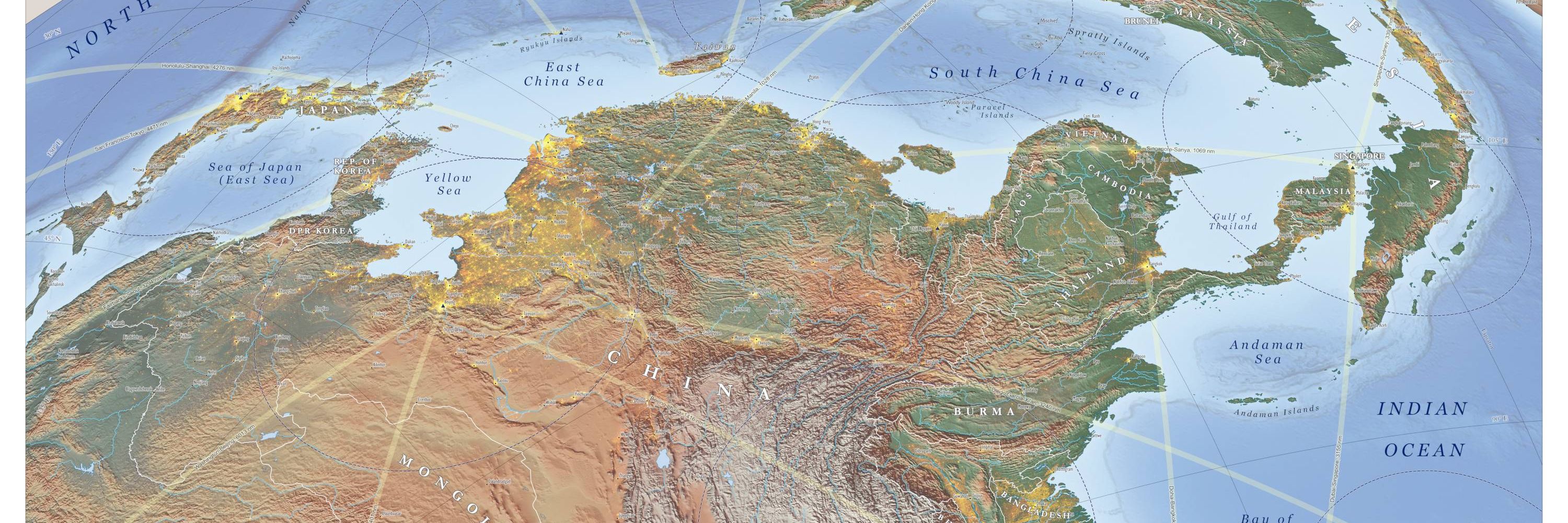
After some helpful comments from testers, I have updated this tool for making simple outline maps on an equidistant projection. Zoom and rotate functions work better now and without a mouse. Make base maps for briefing graphics or coloring books.
mapspam.net/OutlineMap.html
mapspam.net/OutlineMap.html
Outline Atlas — AEQD
mapspam.net
November 22, 2025 at 5:38 PM
After some helpful comments from testers, I have updated this tool for making simple outline maps on an equidistant projection. Zoom and rotate functions work better now and without a mouse. Make base maps for briefing graphics or coloring books.
mapspam.net/OutlineMap.html
mapspam.net/OutlineMap.html

Reposted by Rhodes Cartography
That chart is well worth studying. Share of daily transactions taking place in cash around the world. As an Australian, I’m very much used to cashless everything by now. I’m still totally against going fully cashless.

November 11, 2025 at 6:26 AM
That chart is well worth studying. Share of daily transactions taking place in cash around the world. As an Australian, I’m very much used to cashless everything by now. I’m still totally against going fully cashless.
On Monday afternoon (GMT) I will be giving a lecture at the Royal Geographic Society on Alexander Macomb Mason. Naval history, exploration in Africa, 19th-century century science, and lots of #maps... Register for in-person or online here:
www.rgs.org/events/upcom...
www.rgs.org/events/upcom...


November 8, 2025 at 11:34 AM
On Monday afternoon (GMT) I will be giving a lecture at the Royal Geographic Society on Alexander Macomb Mason. Naval history, exploration in Africa, 19th-century century science, and lots of #maps... Register for in-person or online here:
www.rgs.org/events/upcom...
www.rgs.org/events/upcom...
Reposted by Rhodes Cartography
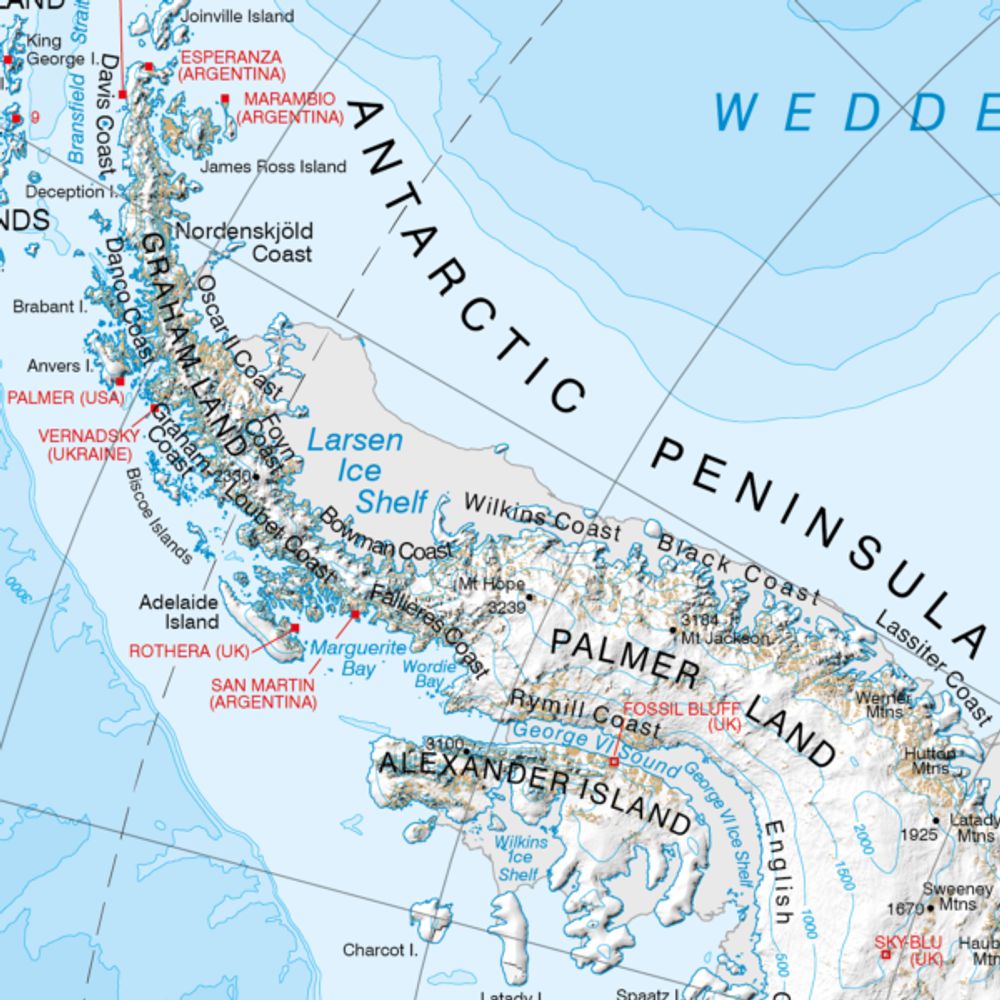
We've recently created a new collection of legacy maps in our Catalogue, which will be added to over time. For now, we have 3 interesting maps available to view and download: data.bas.ac.uk/collections/...
The Scotia Arc is one of our favourites. The map was a massive compilation effort at the time!
The Scotia Arc is one of our favourites. The map was a massive compilation effort at the time!

November 7, 2025 at 2:34 PM
We've recently created a new collection of legacy maps in our Catalogue, which will be added to over time. For now, we have 3 interesting maps available to view and download: data.bas.ac.uk/collections/...
The Scotia Arc is one of our favourites. The map was a massive compilation effort at the time!
The Scotia Arc is one of our favourites. The map was a massive compilation effort at the time!
Reposted by Rhodes Cartography

Celebrate Geography Awareness Week at Brown! From Nov 17-21, IBES & partners will host a career panel, photo contest, workshops, colloquia, and tours highlighting how GIS skills can be used in + beyond the classroom.
Full schedule: https://ibes.brown.edu/news-events/2025-geography-awareness-week
Full schedule: https://ibes.brown.edu/news-events/2025-geography-awareness-week

November 5, 2025 at 5:15 PM
Celebrate Geography Awareness Week at Brown! From Nov 17-21, IBES & partners will host a career panel, photo contest, workshops, colloquia, and tours highlighting how GIS skills can be used in + beyond the classroom.
Full schedule: https://ibes.brown.edu/news-events/2025-geography-awareness-week
Full schedule: https://ibes.brown.edu/news-events/2025-geography-awareness-week
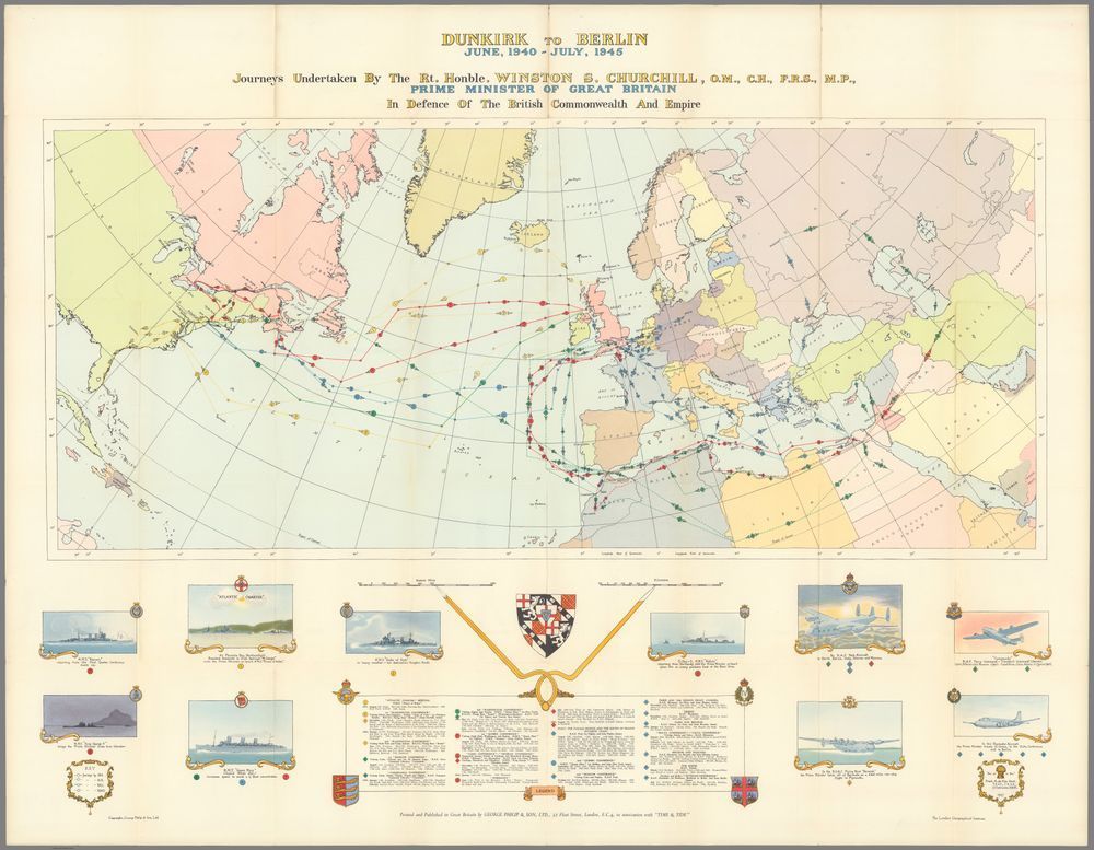
Who was "SHB" that made these maps for Churchill's books?


November 6, 2025 at 3:04 PM
Who was "SHB" that made these maps for Churchill's books?


So glad to receive my copy of Great Power Diplomacy. It was a worthy challenge to make maps for a range of case studies. I am especially grateful that Wess thought to include a "Note on the Maps": a rare chance to reflect on the interplay of maps and strategy.


October 22, 2025 at 8:43 PM
So glad to receive my copy of Great Power Diplomacy. It was a worthy challenge to make maps for a range of case studies. I am especially grateful that Wess thought to include a "Note on the Maps": a rare chance to reflect on the interplay of maps and strategy.
Reposted by Rhodes Cartography


My new map of the Baltic Sea got a strong response last week. Many seemed to appreciate the fresh perspective on maritime geopolitics, and a few asked for a high-resolution download, so I've posted it here:
thinkinginspace.net/f/baltic-sea...
thinkinginspace.net/f/baltic-sea...

Baltic Sea: Oblique Orthographic View of Maritime Geopolitics
I took the existing orthographic oblique style I have used for some other recent maps and made this map after reading a few news stories about the Baltic. This rotation and framing gives a fresh persp...
thinkinginspace.net
October 18, 2025 at 4:48 PM
My new map of the Baltic Sea got a strong response last week. Many seemed to appreciate the fresh perspective on maritime geopolitics, and a few asked for a high-resolution download, so I've posted it here:
thinkinginspace.net/f/baltic-sea...
thinkinginspace.net/f/baltic-sea...


Reposted by Rhodes Cartography

Counterintuitive Comparison Of Relative Population Latitudes Of US, Canada & Europe
Full map: brilliantmaps.com/populatio...
Full map: brilliantmaps.com/populatio...

October 12, 2025 at 12:01 PM
Counterintuitive Comparison Of Relative Population Latitudes Of US, Canada & Europe
Full map: brilliantmaps.com/populatio...
Full map: brilliantmaps.com/populatio...
Great work. Glad you found the tool useful.
Via the map projection app from @thinkinginspace.bsky.social

October 11, 2025 at 4:30 PM
Great work. Glad you found the tool useful.
Been consumed with other things lately and not making enough maps. But had a fresh look at the Baltic and came up with this take with an old style. Labeling needs work, but feels more dynamic than the traditional view.

October 11, 2025 at 4:30 PM
Been consumed with other things lately and not making enough maps. But had a fresh look at the Baltic and came up with this take with an old style. Labeling needs work, but feels more dynamic than the traditional view.
Reposted by Rhodes Cartography


October 6, 2025 at 8:16 PM
Reposted by Rhodes Cartography

September 28, 2025 at 11:01 AM
Reposted by Rhodes Cartography

A nice shift in perceived colour between central and peripheral vision. The fixated disc looks purple while the others look blue.
The effect presumably comes from the absence of S-cones in the fovea.
From Hinnerk Schulz-Hildebrandt:
arxiv.org/pdf/2509.115...
The effect presumably comes from the absence of S-cones in the fovea.
From Hinnerk Schulz-Hildebrandt:
arxiv.org/pdf/2509.115...

September 24, 2025 at 12:04 PM
A nice shift in perceived colour between central and peripheral vision. The fixated disc looks purple while the others look blue.
The effect presumably comes from the absence of S-cones in the fovea.
From Hinnerk Schulz-Hildebrandt:
arxiv.org/pdf/2509.115...
The effect presumably comes from the absence of S-cones in the fovea.
From Hinnerk Schulz-Hildebrandt:
arxiv.org/pdf/2509.115...
Great map. Clear story, excellent use of projection and scale to frame the narrative on the page.
This fantastic map shows just how much Winston Churchill traveled between June 1940 and July 1945. He visited the US, Europe, North Africa, and the Middle East (all the key World War II theaters). Source: buff.ly/ByRIuFT
September 13, 2025 at 1:49 PM
Great map. Clear story, excellent use of projection and scale to frame the narrative on the page.
Reposted by Rhodes Cartography
A Cartographic Tour of Gold Country. Inspired by a trip to the Sierra Foothills, I made a map of the Mother Lode, paired with some vintage maps highlighting different types of mines.
🗺️ #cartography #mapping
pixeum.org/exhibits/715...
🗺️ #cartography #mapping
pixeum.org/exhibits/715...

A Cartographic View of the California Gold Rush
Original map by Robert Simmon
pixeum.org
September 12, 2025 at 4:17 PM
A Cartographic Tour of Gold Country. Inspired by a trip to the Sierra Foothills, I made a map of the Mother Lode, paired with some vintage maps highlighting different types of mines.
🗺️ #cartography #mapping
pixeum.org/exhibits/715...
🗺️ #cartography #mapping
pixeum.org/exhibits/715...
Need a 16x9 map for your PPT? Want bluebook outline maps for a classroom? Are you really into equidistant projections? Do you like fun maps in strange orientations with bold colors?
Skip the image search and make the map that suits your own needs:
www.mapspam.net/OutlineMap.html
Skip the image search and make the map that suits your own needs:
www.mapspam.net/OutlineMap.html


September 7, 2025 at 9:40 AM
Need a 16x9 map for your PPT? Want bluebook outline maps for a classroom? Are you really into equidistant projections? Do you like fun maps in strange orientations with bold colors?
Skip the image search and make the map that suits your own needs:
www.mapspam.net/OutlineMap.html
Skip the image search and make the map that suits your own needs:
www.mapspam.net/OutlineMap.html