


Mount St. Helens in 1980 | #MSH45
@mountsthelens1980.bsky.social
Hi there, I’m Chris. Just sharing my fascination with the 1980 eruption of Mount St. Helens (Lawilátɬa/Loowit) with you for #MSH45.
About Me: https://bsky.app/profile/mountsthelens1980.bsky.social/post/3lohgbvt4ab2d
Links: https://linktr.ee/sthelensin1980
About Me: https://bsky.app/profile/mountsthelens1980.bsky.social/post/3lohgbvt4ab2d
Links: https://linktr.ee/sthelensin1980
Reposted by Mount St. Helens in 1980 | #MSH45

The town of St Helens is just between Liverpool and Manchester. When I was a small child, in Liverpool, Mount St Helens, in Washington, erupted. Not having a grasp of geography, I spent two weeks in mortal fear of dying in a volcanic eruption before my dad set me straight.
November 29, 2025 at 3:20 PM
The town of St Helens is just between Liverpool and Manchester. When I was a small child, in Liverpool, Mount St Helens, in Washington, erupted. Not having a grasp of geography, I spent two weeks in mortal fear of dying in a volcanic eruption before my dad set me straight.
Oh, FYI.
Kilauea's doing its thing right now if you've burnt yourself out of the 14 random college basketball tourneys happening right now.
Kilauea's doing its thing right now if you've burnt yourself out of the 14 random college basketball tourneys happening right now.
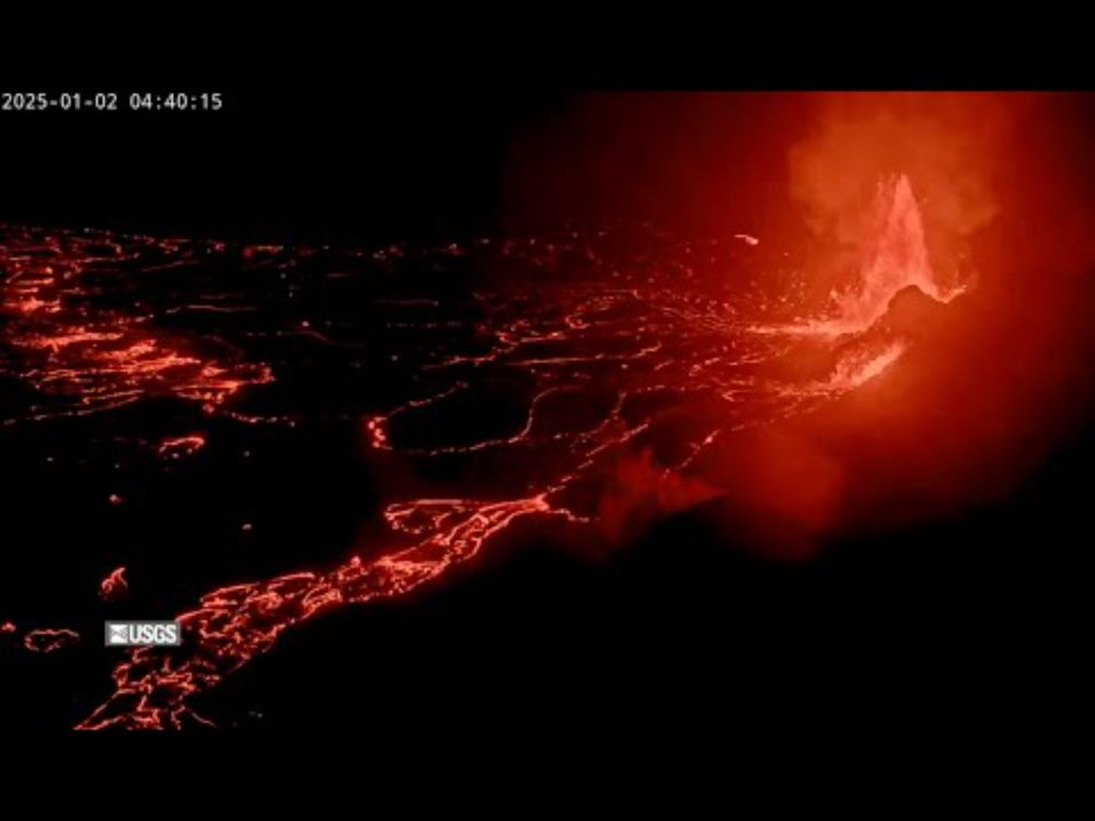
[V1cam] Kīlauea volcano, Hawaii (west Halemaʻumaʻu crater)
YouTube video by USGS
www.youtube.com
November 26, 2025 at 12:54 AM
Oh, FYI.
Kilauea's doing its thing right now if you've burnt yourself out of the 14 random college basketball tourneys happening right now.
Kilauea's doing its thing right now if you've burnt yourself out of the 14 random college basketball tourneys happening right now.
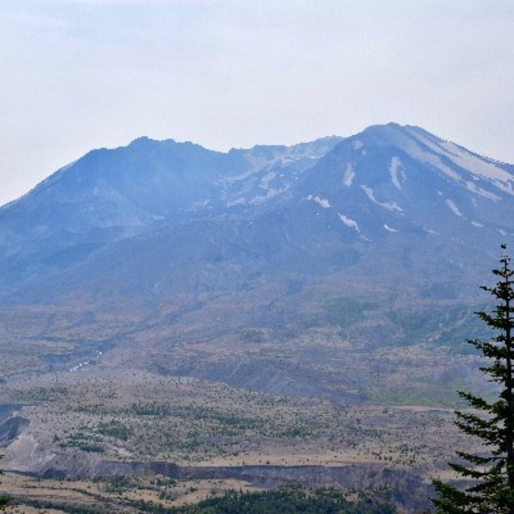
#MSH45 | Nov. 25 and 26, 1980
One month after rising from the depths, the October 1980 lava dome at Mount St. Helens is a 740-ft-wide, 120-ft-high plug in the crater—its top restless with steaming fumaroles.
Embrace the uneasy silence.
One month after rising from the depths, the October 1980 lava dome at Mount St. Helens is a 740-ft-wide, 120-ft-high plug in the crater—its top restless with steaming fumaroles.
Embrace the uneasy silence.


November 26, 2025 at 12:26 AM
#MSH45 | Nov. 25 and 26, 1980
One month after rising from the depths, the October 1980 lava dome at Mount St. Helens is a 740-ft-wide, 120-ft-high plug in the crater—its top restless with steaming fumaroles.
Embrace the uneasy silence.
One month after rising from the depths, the October 1980 lava dome at Mount St. Helens is a 740-ft-wide, 120-ft-high plug in the crater—its top restless with steaming fumaroles.
Embrace the uneasy silence.
Anyone want to help this person out?

For my WIP, I’m doing some rock hounding. I am slowly educating myself about rocks. This was something I found at the base of a waterfall near Mt. St. Helens I believe it’s chalcedony, agate, and quartz.
Anyone know their #rocks?
It almost looks like a geode, but rare there.
Anyone know their #rocks?
It almost looks like a geode, but rare there.

November 25, 2025 at 12:05 AM
Anyone want to help this person out?
Reposted by Mount St. Helens in 1980 | #MSH45
Here's the complete footage from KATU's visit to the "St. Helens" set—including interviews with crew members and their roles.
It's an interesting look into not-quite-major motion picture filming at the dawn of the 80s.
It's an interesting look into not-quite-major motion picture filming at the dawn of the 80s.
November 24, 2025 at 1:41 AM
Here's the complete footage from KATU's visit to the "St. Helens" set—including interviews with crew members and their roles.
It's an interesting look into not-quite-major motion picture filming at the dawn of the 80s.
It's an interesting look into not-quite-major motion picture filming at the dawn of the 80s.
Reposted by Mount St. Helens in 1980 | #MSH45

Derived Ash Height product from @eumetsat.int #meteosat10 suggested that parts of the volcanic ash cloud from the eruption of #HayliGubbi in Ethiopia may have reached heights in the 18-20 km range (black).
November 23, 2025 at 8:39 PM
Derived Ash Height product from @eumetsat.int #meteosat10 suggested that parts of the volcanic ash cloud from the eruption of #HayliGubbi in Ethiopia may have reached heights in the 18-20 km range (black).
Reposted by Mount St. Helens in 1980 | #MSH45
An explosive #eruption of Hayli Gubbi #volcano, located SE of Erta'Ale in the Afar Rift (Ethiopia), began at ~08:30 UTC on Nov 23. Eruption onset was fortuitously captured by a @planet.com overpass at 08:31 UTC. Hayli Gubbi has no record of Holocene eruptions. Toulouse VAAC reporting ash to ~15 km.


November 23, 2025 at 5:23 PM
An explosive #eruption of Hayli Gubbi #volcano, located SE of Erta'Ale in the Afar Rift (Ethiopia), began at ~08:30 UTC on Nov 23. Eruption onset was fortuitously captured by a @planet.com overpass at 08:31 UTC. Hayli Gubbi has no record of Holocene eruptions. Toulouse VAAC reporting ash to ~15 km.
Meanwhile, in other volcanic activity, check out this eruption plume from Hayli Gubbi in Ethiopia.
It's its first, at least according to the Global Volcanism Program's records, in recorded history. So, how about that? You live in a moment when a novel volcanic event occurred.
It's its first, at least according to the Global Volcanism Program's records, in recorded history. So, how about that? You live in a moment when a novel volcanic event occurred.
November 24, 2025 at 1:53 AM
Meanwhile, in other volcanic activity, check out this eruption plume from Hayli Gubbi in Ethiopia.
It's its first, at least according to the Global Volcanism Program's records, in recorded history. So, how about that? You live in a moment when a novel volcanic event occurred.
It's its first, at least according to the Global Volcanism Program's records, in recorded history. So, how about that? You live in a moment when a novel volcanic event occurred.
Here's the complete footage from KATU's visit to the "St. Helens" set—including interviews with crew members and their roles.
It's an interesting look into not-quite-major motion picture filming at the dawn of the 80s.
It's an interesting look into not-quite-major motion picture filming at the dawn of the 80s.
November 24, 2025 at 1:41 AM
Here's the complete footage from KATU's visit to the "St. Helens" set—including interviews with crew members and their roles.
It's an interesting look into not-quite-major motion picture filming at the dawn of the 80s.
It's an interesting look into not-quite-major motion picture filming at the dawn of the 80s.
Reposted by Mount St. Helens in 1980 | #MSH45
#MSH45 | The Film: Sieber's Folly Pays Off
Along with Harry Truman's family, among others, "St. Helens" executive producer Michael Murphy also struck a deal with one Otto Sieber.
This is the Seattle filmmaker whose May trip into the devastated area nearly cost him and his team their lives.
Along with Harry Truman's family, among others, "St. Helens" executive producer Michael Murphy also struck a deal with one Otto Sieber.
This is the Seattle filmmaker whose May trip into the devastated area nearly cost him and his team their lives.
November 23, 2025 at 1:50 AM
#MSH45 | The Film: Sieber's Folly Pays Off
Along with Harry Truman's family, among others, "St. Helens" executive producer Michael Murphy also struck a deal with one Otto Sieber.
This is the Seattle filmmaker whose May trip into the devastated area nearly cost him and his team their lives.
Along with Harry Truman's family, among others, "St. Helens" executive producer Michael Murphy also struck a deal with one Otto Sieber.
This is the Seattle filmmaker whose May trip into the devastated area nearly cost him and his team their lives.
November 23, 2025 at 1:50 AM
#MSH45 | The Film: Sieber's Folly Pays Off
Along with Harry Truman's family, among others, "St. Helens" executive producer Michael Murphy also struck a deal with one Otto Sieber.
This is the Seattle filmmaker whose May trip into the devastated area nearly cost him and his team their lives.
Along with Harry Truman's family, among others, "St. Helens" executive producer Michael Murphy also struck a deal with one Otto Sieber.
This is the Seattle filmmaker whose May trip into the devastated area nearly cost him and his team their lives.
Reposted by Mount St. Helens in 1980 | #MSH45


Reposted by Mount St. Helens in 1980 | #MSH45

This is so cool! I had an amazing undergraduate student right after I started my job, and his research project included looking at the 1842 eruption. We concluded it was not just a phreatic event, but a bit more exciting. I wish this letter had been available then.
🌋⚒️🧪
🌋⚒️🧪
November 22, 2025 at 4:51 PM
This is so cool! I had an amazing undergraduate student right after I started my job, and his research project included looking at the 1842 eruption. We concluded it was not just a phreatic event, but a bit more exciting. I wish this letter had been available then.
🌋⚒️🧪
🌋⚒️🧪
Reposted by Mount St. Helens in 1980 | #MSH45
#MSH45 | The Movie: Lights, Camera, Action!
It's November 1980.
Portland’s KATU gives a peek behind the scenes of the filming of “St. Helens,” as Harry Truman, brought back to life by Art Carney, holds a press conference at a stand-in Mount St. Helens Lodge — Elk Lake Lodge near Mount Bachelor.
It's November 1980.
Portland’s KATU gives a peek behind the scenes of the filming of “St. Helens,” as Harry Truman, brought back to life by Art Carney, holds a press conference at a stand-in Mount St. Helens Lodge — Elk Lake Lodge near Mount Bachelor.
November 21, 2025 at 7:00 PM
#MSH45 | The Movie: Lights, Camera, Action!
It's November 1980.
Portland’s KATU gives a peek behind the scenes of the filming of “St. Helens,” as Harry Truman, brought back to life by Art Carney, holds a press conference at a stand-in Mount St. Helens Lodge — Elk Lake Lodge near Mount Bachelor.
It's November 1980.
Portland’s KATU gives a peek behind the scenes of the filming of “St. Helens,” as Harry Truman, brought back to life by Art Carney, holds a press conference at a stand-in Mount St. Helens Lodge — Elk Lake Lodge near Mount Bachelor.
November 21, 2025 at 7:00 PM
#MSH45 | The Movie: Lights, Camera, Action!
It's November 1980.
Portland’s KATU gives a peek behind the scenes of the filming of “St. Helens,” as Harry Truman, brought back to life by Art Carney, holds a press conference at a stand-in Mount St. Helens Lodge — Elk Lake Lodge near Mount Bachelor.
It's November 1980.
Portland’s KATU gives a peek behind the scenes of the filming of “St. Helens,” as Harry Truman, brought back to life by Art Carney, holds a press conference at a stand-in Mount St. Helens Lodge — Elk Lake Lodge near Mount Bachelor.
Reposted by Mount St. Helens in 1980 | #MSH45
#MSH45 | The Movie: Sept. 1980
Producer Roger Lewis dreams of bringing Mount St. Helens to the big screen. With tentative funding from Taft International Films, he heads to Washington for research and interviews.
For now, he believes he's the only one chasing this story—but only for so long.
Producer Roger Lewis dreams of bringing Mount St. Helens to the big screen. With tentative funding from Taft International Films, he heads to Washington for research and interviews.
For now, he believes he's the only one chasing this story—but only for so long.


November 21, 2025 at 1:24 AM
#MSH45 | The Movie: Sept. 1980
Producer Roger Lewis dreams of bringing Mount St. Helens to the big screen. With tentative funding from Taft International Films, he heads to Washington for research and interviews.
For now, he believes he's the only one chasing this story—but only for so long.
Producer Roger Lewis dreams of bringing Mount St. Helens to the big screen. With tentative funding from Taft International Films, he heads to Washington for research and interviews.
For now, he believes he's the only one chasing this story—but only for so long.
November 21, 2025 at 1:24 AM
#MSH45 | The Movie: Sept. 1980
Producer Roger Lewis dreams of bringing Mount St. Helens to the big screen. With tentative funding from Taft International Films, he heads to Washington for research and interviews.
For now, he believes he's the only one chasing this story—but only for so long.
Producer Roger Lewis dreams of bringing Mount St. Helens to the big screen. With tentative funding from Taft International Films, he heads to Washington for research and interviews.
For now, he believes he's the only one chasing this story—but only for so long.
Folks, I...
I mean, we are talking the time of Boogie Nights, here—but before Alfred Molina on cocaine appears, so better times?
I should stop. I'm not deflecting well. I'll stop.
I mean, we are talking the time of Boogie Nights, here—but before Alfred Molina on cocaine appears, so better times?
I should stop. I'm not deflecting well. I'll stop.

November 20, 2025 at 11:48 PM
Folks, I...
I mean, we are talking the time of Boogie Nights, here—but before Alfred Molina on cocaine appears, so better times?
I should stop. I'm not deflecting well. I'll stop.
I mean, we are talking the time of Boogie Nights, here—but before Alfred Molina on cocaine appears, so better times?
I should stop. I'm not deflecting well. I'll stop.
Reposted by Mount St. Helens in 1980 | #MSH45

Semeru, Indonesia is erupting. Communities are being evacuated.
Incredible footage of pyroclastic density currents in the news.
youtube.com/watch?v=ducv...
Incredible footage of pyroclastic density currents in the news.
youtube.com/watch?v=ducv...

Indonesia's Mount Semeru erupts and covers villages with falling ash
YouTube video by Associated Press
youtube.com
November 20, 2025 at 10:26 PM
Semeru, Indonesia is erupting. Communities are being evacuated.
Incredible footage of pyroclastic density currents in the news.
youtube.com/watch?v=ducv...
Incredible footage of pyroclastic density currents in the news.
youtube.com/watch?v=ducv...
Reposted by Mount St. Helens in 1980 | #MSH45
#MSH45 | Oct. 24, 1980
Would you stand next to a lava dome just days after an eruption?
USGS geologists Don Swanson and Terry Leighley did, along with others who investigated this new hill of igneous origin.
Would you stand next to a lava dome just days after an eruption?
USGS geologists Don Swanson and Terry Leighley did, along with others who investigated this new hill of igneous origin.


October 26, 2025 at 2:36 AM
#MSH45 | Oct. 24, 1980
Would you stand next to a lava dome just days after an eruption?
USGS geologists Don Swanson and Terry Leighley did, along with others who investigated this new hill of igneous origin.
Would you stand next to a lava dome just days after an eruption?
USGS geologists Don Swanson and Terry Leighley did, along with others who investigated this new hill of igneous origin.
Reposted by Mount St. Helens in 1980 | #MSH45
#MSH45 | May 1980
Morton, Washington
The mushroom cloud rose to the south, blotting out the sky and the sun. As it climbed higher, it drifted closer—then came the fallout. Mudballs and ash rained from the sky.
When it was over, the town lay under a thin gray grit. The cleanup would take weeks.
Morton, Washington
The mushroom cloud rose to the south, blotting out the sky and the sun. As it climbed higher, it drifted closer—then came the fallout. Mudballs and ash rained from the sky.
When it was over, the town lay under a thin gray grit. The cleanup would take weeks.
October 26, 2025 at 11:08 PM
#MSH45 | May 1980
Morton, Washington
The mushroom cloud rose to the south, blotting out the sky and the sun. As it climbed higher, it drifted closer—then came the fallout. Mudballs and ash rained from the sky.
When it was over, the town lay under a thin gray grit. The cleanup would take weeks.
Morton, Washington
The mushroom cloud rose to the south, blotting out the sky and the sun. As it climbed higher, it drifted closer—then came the fallout. Mudballs and ash rained from the sky.
When it was over, the town lay under a thin gray grit. The cleanup would take weeks.
Reposted by Mount St. Helens in 1980 | #MSH45
#MSH45 | Nov. 13, 1980
At lower elevations, the snow came on more slowly.
Here in the Smith Creek drainage, as captured by USGS scientists, the barren land was as stark as it was immediately after the May 18 eruption.
At lower elevations, the snow came on more slowly.
Here in the Smith Creek drainage, as captured by USGS scientists, the barren land was as stark as it was immediately after the May 18 eruption.

November 20, 2025 at 1:42 AM
#MSH45 | Nov. 13, 1980
At lower elevations, the snow came on more slowly.
Here in the Smith Creek drainage, as captured by USGS scientists, the barren land was as stark as it was immediately after the May 18 eruption.
At lower elevations, the snow came on more slowly.
Here in the Smith Creek drainage, as captured by USGS scientists, the barren land was as stark as it was immediately after the May 18 eruption.
Reposted by Mount St. Helens in 1980 | #MSH45
Okay, phew. I'm done. Not a scientist, but have worked with many over the years...and I feel bad for them.
Anyway, here's our good friend Mount St. Helens on Nov. 12, 1980.
Anyway, here's our good friend Mount St. Helens on Nov. 12, 1980.

November 19, 2025 at 11:51 PM
Okay, phew. I'm done. Not a scientist, but have worked with many over the years...and I feel bad for them.
Anyway, here's our good friend Mount St. Helens on Nov. 12, 1980.
Anyway, here's our good friend Mount St. Helens on Nov. 12, 1980.
Okay, last post about it.

Experts debunk viral headline claiming increase in seismic activity at Mount Rainier
YouTube video by KOMO News
www.youtube.com
November 20, 2025 at 2:16 AM
Okay, last post about it.
#MSH45 | Nov. 13, 1980
At lower elevations, the snow came on more slowly.
Here in the Smith Creek drainage, as captured by USGS scientists, the barren land was as stark as it was immediately after the May 18 eruption.
At lower elevations, the snow came on more slowly.
Here in the Smith Creek drainage, as captured by USGS scientists, the barren land was as stark as it was immediately after the May 18 eruption.
November 20, 2025 at 1:42 AM
#MSH45 | Nov. 13, 1980
At lower elevations, the snow came on more slowly.
Here in the Smith Creek drainage, as captured by USGS scientists, the barren land was as stark as it was immediately after the May 18 eruption.
At lower elevations, the snow came on more slowly.
Here in the Smith Creek drainage, as captured by USGS scientists, the barren land was as stark as it was immediately after the May 18 eruption.