

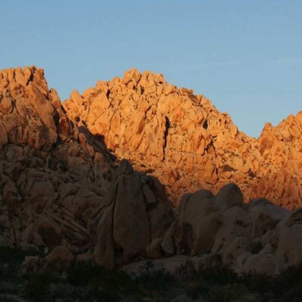
Looks like CHP is checking for debris from what must have been a bunch of detonations/etc. at Pendleton. 10/18/25 1416PT #pendleton #i5closure #shutdown #traffic #sandiego

October 18, 2025 at 9:17 PM
Everybody can reply
5 reposts
9 likes
1 saves

yep! made in Quickmap on Shady Knight's beta branch :)
there are already some awesome community maps on Discord!
there are already some awesome community maps on Discord!
September 30, 2025 at 1:01 PM
Everybody can reply
1 likes

State Route 178 in San Bernardino County is closed just east of Ridgecrest after the highway sustained heavy damage during last night's storm.
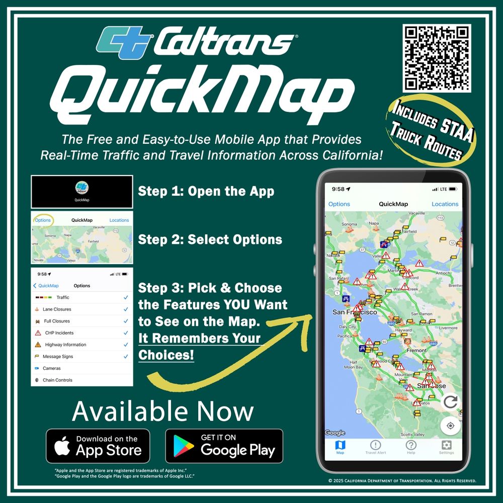
For the latest on highway conditions, visit quickmap.dot.ca.gov or download the #quickmap app.
www.youtube.com/shorts/K-r4r...
For the latest on highway conditions, visit quickmap.dot.ca.gov or download the #quickmap app.
www.youtube.com/shorts/K-r4r...
September 19, 2025 at 6:27 PM
Everybody can reply
1 reposts
1 likes
I love CalTrans QuickMap app almost as much as I do WatchDutyApp. Pulsepoint is a distant 3rd. 😹💚
September 19, 2025 at 4:03 AM
Everybody can reply
3 likes

L’ultima luna
La vide solo un bimbo appena nato
Aveva occhi tondi e neri e fondi
E non piangeva
Con grandi ali prese la luna tra le mani
E volò via e volò via
Era l’uomo di domani l’uomo di domani.
- L’ultima Luna, Lucio Dalla -
Quickmap dalla NASA
La vide solo un bimbo appena nato
Aveva occhi tondi e neri e fondi
E non piangeva
Con grandi ali prese la luna tra le mani
E volò via e volò via
Era l’uomo di domani l’uomo di domani.
- L’ultima Luna, Lucio Dalla -
Quickmap dalla NASA
QuickMap
LROC QuickMap, a powerful map interface to browse Lunar data from NASA/LRO and other missions. Explore the Moon in both 2D and 3D. Developed by Applied Coherent Technology and customized for the LROC ...
quickmap.lroc.im-ldi.com
August 13, 2025 at 8:02 PM
Everybody can reply
1 reposts
2 likes

Looking north with synthetic Quickmap 3D views makes it clear that the 'northern crater' I had trouble matching with the panorama before I flipped it can in fact be identified. Here it is, about 60 m north of he lander and about 10 m across. Small craters […]
[Original post on mastodon.social]
[Original post on mastodon.social]

August 6, 2025 at 7:04 AM
Everybody can reply
Here is the panorama looking west in the middle (the sun is high in the sky so shadows don''t help much). The left end with the hills looks south, the right end with the crater looks north. Now the distant hills, when tilted as at lower left, do look more […]
[Original post on mastodon.social]
[Original post on mastodon.social]

August 4, 2025 at 6:55 AM
Everybody can reply
1 likes


Caltrans Quickmap
also can be found at cad.chp.ca.gov
also can be found at cad.chp.ca.gov
CHP Traffic
cad.chp.ca.gov
July 18, 2025 at 7:54 PM
Everybody can reply
1 likes
Hitting the road this weekend? Before you set out, check QuickMap.dot.ca.gov or download the #QuickMap app to get the latest info on road conditions, lane closures, and rest area availability.
July 11, 2025 at 3:17 PM
Everybody can reply
1 reposts
2 likes

Highway 36 Expected to Reopen to One-Way Traffic Thursday Near Swimmer’s Delight #Highway36 #CaltransDistrict1 #SlideRecovery #GrizzlyCreek #HumboldtCounty #RoadReopening #OneWayTraffic #QuickMap

Highway 36 Expected to Reopen to One-Way Traffic Thursday Near Swimmer’s Delight
Caltrans crews, loggers, and helicopters have cleared over 100 logs from a massive slide east of Swimmer’s Delight, setting the stage for limited reopening of Highway 36 this Thursday.
kymkemp.com
July 1, 2025 at 12:40 AM
Everybody can reply

It's time for a new episode of What is Roleplay featuring
@davidblandyrpgs.bsky.social and an actual play quickmap by
@jogbrogzin.bsky.social #indierpg #podcast beyondcataclysm.co.uk/podcast/what...
@davidblandyrpgs.bsky.social and an actual play quickmap by
@jogbrogzin.bsky.social #indierpg #podcast beyondcataclysm.co.uk/podcast/what...

What is Roleplay #25: No Prep Play with David Blandy - Beyond Cataclysm
Welcome to Episode 25 of ‘What Is Roleplay?' This episode we are joined by artist and tabletop roleplay game designer David Blandy to discuss No Prep Play Chris asks David what No Prep Play is Simply ...
beyondcataclysm.co.uk
June 19, 2025 at 1:29 PM
Everybody can reply
1 reposts
2 quotes
6 likes
Work continues this week on reopening State Route 120 W at Lee Vining. Snow has been cleared, but there are vital pavement repairs and rock work that needs to be completed before the road can reopen. We will provide updates on the status of the highway as they come in.
#QuickMap
#QuickMap

May 19, 2025 at 5:57 PM
Everybody can reply
1 reposts
1 quotes
4 likes
State Route 108 (Sonora Pass) has reopened from its winter closure.
While the highway is open to vehicles now, there is a snowstorm in the forecast that might prompt a storm closure. Be sure to follow us here for updates and check #QuickMap before you go to get the latest on highway conditions.
While the highway is open to vehicles now, there is a snowstorm in the forecast that might prompt a storm closure. Be sure to follow us here for updates and check #QuickMap before you go to get the latest on highway conditions.

May 15, 2025 at 5:41 PM
Everybody can reply

Extra quickmap ! Merci 👍👍👍👍👍
May 2, 2025 at 4:20 PM
Everybody can reply
1 likes
Our Lee Vining Maintenance Crew reached the eastern entrance to Yosemite National Park on State Route 120 West yesterday. While this is a big seasonal milestone, there is still work to do before the highway can reopen.
For road conditions, visit quickmap.dot.ca.gov or download the #quickmap app.
For road conditions, visit quickmap.dot.ca.gov or download the #quickmap app.
April 25, 2025 at 5:45 PM
Everybody can reply
4 likes
Exit 165 on State Route 58 north of Mojave has reopened from its wind closure.
Before you leave home, check quickmap.dot.ca.gov or download the #quickmap app to get the latest info on California highway conditions.
Before you leave home, check quickmap.dot.ca.gov or download the #quickmap app to get the latest info on California highway conditions.

April 3, 2025 at 4:16 PM
Everybody can reply
🌨️Winter isn't going down without a fight. More snow is in the forecast for the higher elevations of Mono County today, per our friends at the National Weather Service in Reno.
Remember to pack your snow chains and check #QuickMap before you go to get the latest info on highway conditions.
Remember to pack your snow chains and check #QuickMap before you go to get the latest info on highway conditions.

April 1, 2025 at 4:11 PM
Everybody can reply
Working on next week's column.


March 16, 2025 at 3:40 PM
Everybody can reply
1 likes
Snow is falling from Tehachapi to Mammoth Lakes and beyond. Even the Coso Junction Rest Area in Inyo County is seeing flakes. When the weather is like this, remember to slow down, create space between vehicles, and check the #Quickmap app or quickmap.dot.ca.gov before you go.
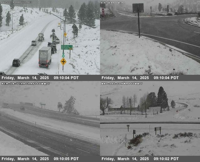
March 14, 2025 at 4:48 PM
Everybody can reply
2 likes
Good luck & safe journey! It's been raining in SoCal so remember how people drive in the rain here *wink wink* Also, CalTrans QuickMap app is handy for traffic.💚
March 12, 2025 at 12:19 PM
Everybody can reply
2 likes
James used the LROC Quickmap to create a lot of his cool Moon figures. Check out the website here: quickmap.lroc.asu.edu #LPSC2025
QuickMap
LROC QuickMap, a powerful map interface to browse Lunar data from NASA/LRO and other missions. Explore the Moon in both 2D and 3D. Developed by Applied Coherent Technology and customized for the LROC ...
quickmap.lroc.asu.edu
March 11, 2025 at 7:53 PM
Everybody can reply
2 reposts
6 likes

I've been busy reconstructing the landing profile of #BlueGhost from the amazing landing video.
Relative to the LRO NAC mosaic from Quickmap, my landing coordinate estimate is 18.56349°N, 61.80990°E
#planetsci #BGM1
Relative to the LRO NAC mosaic from Quickmap, my landing coordinate estimate is 18.56349°N, 61.80990°E
#planetsci #BGM1


March 4, 2025 at 11:12 PM
Everybody can reply
31 reposts
1 quotes
130 likes
The crater Giordano Bruno is just beyond the limits of the visible side of the Moon, so close I wonder if a bit of it's outer rim might barely show above the limb under the best lighting, Lunar libration and Earthly viewing geometry. On October 7 1959 the Soviet Luna 3 probe first revealed it to us.


February 18, 2025 at 5:12 AM
Everybody can reply
2 reposts
13 likes
UPDATE: U.S. 395 over Conway Summit (between Lee Vining and Bridgeport) has reopened with chain control restrictions. Drivers should visit QuickMap.dot.ca.gov or download the #Quickmap app to get the latest highway conditions before they leave home.

February 15, 2025 at 2:21 AM
Everybody can reply