


Johnny K
@stormchaser4850.bsky.social
*Regardless of the method or source, you should ALWAYS STAY WEATHER AWARE as weather is ALWAYS changing*
(All weather, all the time)
TikTOK: https://www.tiktok.com/@alwaysstayweatheraware?lang=en
(All weather, all the time)
TikTOK: https://www.tiktok.com/@alwaysstayweatheraware?lang=en
Reposted by Johnny K

Reposted by Johnny K

Updates on the Midwest winter storm and impacts today from lake effect snow and snow squalls in the eastern Lakes and Northeast. open.substack.com/pub/balanced...

Major winter storm to cause significant travel impacts in Midwest next couple of days
Lake effect snow and snow squalls an issue today in the eastern Great Lakes and Northeast
open.substack.com
November 28, 2025 at 4:34 PM
Updates on the Midwest winter storm and impacts today from lake effect snow and snow squalls in the eastern Lakes and Northeast. open.substack.com/pub/balanced...
Reposted by Johnny K

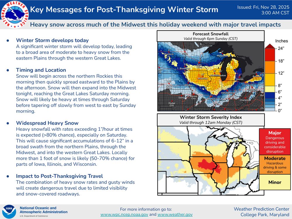
Two winter storms will cause dangerous travel conditions across the northern tier of the country into the weekend. Here are the latest Key Messages for these storms.

November 28, 2025 at 3:38 PM
Two winter storms will cause dangerous travel conditions across the northern tier of the country into the weekend. Here are the latest Key Messages for these storms.


November 28, 2025 at 12:21 PM
( #NWSWPC): A significant #WinterSTORM will bring widespread HEAVY #SNOW to much of the Midwest through this upcoming weekend.
HEAVY #SNOWFALL accumulating to 6-12"+ will create DANGEROUS travel for many areas, including #DesMoines, #Chicago, and #Milwaukee .⚠️ #IAwx #ILwx #WIwx #USwx #wx #wxsky
HEAVY #SNOWFALL accumulating to 6-12"+ will create DANGEROUS travel for many areas, including #DesMoines, #Chicago, and #Milwaukee .⚠️ #IAwx #ILwx #WIwx #USwx #wx #wxsky

November 28, 2025 at 12:02 PM
( #NWSWPC): A significant #WinterSTORM will bring widespread HEAVY #SNOW to much of the Midwest through this upcoming weekend.
HEAVY #SNOWFALL accumulating to 6-12"+ will create DANGEROUS travel for many areas, including #DesMoines, #Chicago, and #Milwaukee .⚠️ #IAwx #ILwx #WIwx #USwx #wx #wxsky
HEAVY #SNOWFALL accumulating to 6-12"+ will create DANGEROUS travel for many areas, including #DesMoines, #Chicago, and #Milwaukee .⚠️ #IAwx #ILwx #WIwx #USwx #wx #wxsky
Post- #Thanksgiving significant early season #WinterSTORM set to unfold on Friday (November 28) and through the weekend (November 29-30) across the Northern Plains into the #USwx Midwest
***Widespread Winter STORM watches, warnings and advisories in effect***
#wx #wxsky
***Widespread Winter STORM watches, warnings and advisories in effect***
#wx #wxsky
November 28, 2025 at 12:14 AM
Post- #Thanksgiving significant early season #WinterSTORM set to unfold on Friday (November 28) and through the weekend (November 29-30) across the Northern Plains into the #USwx Midwest
***Widespread Winter STORM watches, warnings and advisories in effect***
#wx #wxsky
***Widespread Winter STORM watches, warnings and advisories in effect***
#wx #wxsky


( #NWSWPC): A SIGNIFICANT SNOWSTORM will impact a good portion of the Northern Plains and Midwest starting Friday and carrying through Sunday morning. Several inches of snow will make for dangerous travel conditions, so be sure to plan accordingly as we move into the weekend. #USwx #wx #wxsky

November 27, 2025 at 9:58 PM
Reposted by Johnny K
A significant winter storm is likely to impact portions of the Northern Plains, Upper Midwest, and Great Lakes beginning Friday through this weekend, which will impact post-Thanksgiving travel.

November 27, 2025 at 7:09 PM
A significant winter storm is likely to impact portions of the Northern Plains, Upper Midwest, and Great Lakes beginning Friday through this weekend, which will impact post-Thanksgiving travel.
Reposted by Johnny K

Sneak peek of the next addition to PolarWx - AIFS ensembles including estimated precipitation types:


November 27, 2025 at 3:48 PM
Sneak peek of the next addition to PolarWx - AIFS ensembles including estimated precipitation types:
Reposted by Johnny K
This Thanksgiving, we want to give thanks to you, our dedicated followers who act as local weather heroes every day. You are a critical link between our forecasts/warnings and your family and friends. We know many of you are weather enthusiasts and thank you for your service to your community!

November 27, 2025 at 12:01 PM
This Thanksgiving, we want to give thanks to you, our dedicated followers who act as local weather heroes every day. You are a critical link between our forecasts/warnings and your family and friends. We know many of you are weather enthusiasts and thank you for your service to your community!


November 27, 2025 at 12:20 PM
Reposted by Johnny K

Reposted by Johnny K

Unless Boston can get 0.1" with a snow shower on Friday, it will make 7 straight Novembers without measureable snow. Ties the longest stretch on record (2005-2011 also 7 straight).

November 26, 2025 at 8:27 PM
Unless Boston can get 0.1" with a snow shower on Friday, it will make 7 straight Novembers without measureable snow. Ties the longest stretch on record (2005-2011 also 7 straight).
( #NWSWPC): A significant #WINTER #STORM continues to impact areas of the Upper Midwest and Great Lakes region today. The threat for HEAVY #SNOW and gusty winds will carry through the end of the week across the Great Lakes leading to hazardous travel conditions through the end of the week. #USwx #wx

November 26, 2025 at 8:10 PM
( #NWSWPC): A significant #WINTER #STORM continues to impact areas of the Upper Midwest and Great Lakes region today. The threat for HEAVY #SNOW and gusty winds will carry through the end of the week across the Great Lakes leading to hazardous travel conditions through the end of the week. #USwx #wx
Reposted by Johnny K

A major winter storm targets the Midwest after Thanksgiving. Heavy snow is expected across Minnesota, Iowa, Wisconsin, and Illinois starting Friday evening, with totals potentially exceeding 8 inches. An arctic blast follows next week with hazardous sub-zero temperatures.
November 26, 2025 at 6:30 PM
A major winter storm targets the Midwest after Thanksgiving. Heavy snow is expected across Minnesota, Iowa, Wisconsin, and Illinois starting Friday evening, with totals potentially exceeding 8 inches. An arctic blast follows next week with hazardous sub-zero temperatures.
Live: #Houghton #Michigan ( #MIwx ) via #MichiganTech ) www.mtu.edu/webcams/
#BLIZZARD in progress with #BlizzardWARNING in effect through early Thursday morning (November 27)/#Thanksgiving Day
#wx #wxsky
#BLIZZARD in progress with #BlizzardWARNING in effect through early Thursday morning (November 27)/#Thanksgiving Day
#wx #wxsky
November 26, 2025 at 1:36 PM
Live: #Houghton #Michigan ( #MIwx ) via #MichiganTech ) www.mtu.edu/webcams/
#BLIZZARD in progress with #BlizzardWARNING in effect through early Thursday morning (November 27)/#Thanksgiving Day
#wx #wxsky
#BLIZZARD in progress with #BlizzardWARNING in effect through early Thursday morning (November 27)/#Thanksgiving Day
#wx #wxsky


November 26, 2025 at 12:20 PM
#Thanksgiving #BLIZZARD set to unfold across portions of the Upper Peninsula of #Michigan ( #MIwx ) including #Marquette from Wednesday through early Thursday (November 26-27)
(WLUC )-TV: "You can see sustained winds could approach 50 mph"
"....very dangerous travel for us"
#wx #wxsky
(WLUC )-TV: "You can see sustained winds could approach 50 mph"
"....very dangerous travel for us"
#wx #wxsky
November 26, 2025 at 1:38 AM
#Thanksgiving #BLIZZARD set to unfold across portions of the Upper Peninsula of #Michigan ( #MIwx ) including #Marquette from Wednesday through early Thursday (November 26-27)
(WLUC )-TV: "You can see sustained winds could approach 50 mph"
"....very dangerous travel for us"
#wx #wxsky
(WLUC )-TV: "You can see sustained winds could approach 50 mph"
"....very dangerous travel for us"
#wx #wxsky

( #NWSHouston): Here are the preliminary damage survey results from yesterday's storms. We have confirmed TWO #TORNADOES so far. The first was in the Riata Ranch area with estimated winds of 110 MPH. The second was in the Klein area with estimated winds of 116 MPH. #TXwx ##HOUwx #Houston #wx #wxsky

November 25, 2025 at 10:48 PM
( #NWSHouston): Here are the preliminary damage survey results from yesterday's storms. We have confirmed TWO #TORNADOES so far. The first was in the Riata Ranch area with estimated winds of 110 MPH. The second was in the Klein area with estimated winds of 116 MPH. #TXwx ##HOUwx #Houston #wx #wxsky
( #NWSMarquette): HEAVY #SNOW is expected in the western U.P tonight with rates of 1-2 inches per hour. Rain changes to snow for the central and eastern U.P on Wednesday with rates up to 1 inch per hour. Lake effect will linger into #Thanksgiving day for the NW wind snowbelts. #Michigan #MIwx #wx

November 25, 2025 at 10:44 PM
( #NWSMarquette): HEAVY #SNOW is expected in the western U.P tonight with rates of 1-2 inches per hour. Rain changes to snow for the central and eastern U.P on Wednesday with rates up to 1 inch per hour. Lake effect will linger into #Thanksgiving day for the NW wind snowbelts. #Michigan #MIwx #wx
Reposted by Johnny K
In the north-central U.S., a storm will bring heavy snow and gusty to high winds over parts of the northern Plains and Upper Midwest today before moving across the Great Lakes with heavy lake effect snow Wednesday into Thanksgiving Day.
Traveling for the holiday? Check weather.gov for the latest.
Traveling for the holiday? Check weather.gov for the latest.
November 25, 2025 at 9:51 PM
In the north-central U.S., a storm will bring heavy snow and gusty to high winds over parts of the northern Plains and Upper Midwest today before moving across the Great Lakes with heavy lake effect snow Wednesday into Thanksgiving Day.
Traveling for the holiday? Check weather.gov for the latest.
Traveling for the holiday? Check weather.gov for the latest.