


SRG SCIENCE
@srg-science.bsky.social
Reposted by SRG SCIENCE

Linksextremismus vermeidet zivile Ziele, zivile Opfer und geht gezielt auf Einzelpersonen in Schlüsselstellungen oder auf Infrastruktur, die Macht versorgt.
Einen Stadtteil mit einem hohen Anteil vulnerabler BürgerInnen lahmlegen ist niemals linksextrem.
Nie. Wer das glaubt, glaubt jeden Scheiß.
Einen Stadtteil mit einem hohen Anteil vulnerabler BürgerInnen lahmlegen ist niemals linksextrem.
Nie. Wer das glaubt, glaubt jeden Scheiß.
January 5, 2026 at 8:25 AM
Linksextremismus vermeidet zivile Ziele, zivile Opfer und geht gezielt auf Einzelpersonen in Schlüsselstellungen oder auf Infrastruktur, die Macht versorgt.
Einen Stadtteil mit einem hohen Anteil vulnerabler BürgerInnen lahmlegen ist niemals linksextrem.
Nie. Wer das glaubt, glaubt jeden Scheiß.
Einen Stadtteil mit einem hohen Anteil vulnerabler BürgerInnen lahmlegen ist niemals linksextrem.
Nie. Wer das glaubt, glaubt jeden Scheiß.
Reposted by SRG SCIENCE

A semi-convective low moving through the Strait of Gibraltar into the Mediterranean Sea. 🐻⌚️
January 4, 2026 at 6:41 PM
A semi-convective low moving through the Strait of Gibraltar into the Mediterranean Sea. 🐻⌚️
Reposted by SRG SCIENCE

Deutschland soll also "mehr arbeiten"
-weil Jens Spahn bei seinen Maskendeals zu viel Geld verpulvert hat.
-weil Markus Söder den Diesel der Bauern bezuschusst.
-weil GasKathi Reiche den Ausbau günstiger Erneuerbarer Energie blockiert.
-weil Friedrich Merz innerdeutsche Flüge billiger machen will.
-weil Jens Spahn bei seinen Maskendeals zu viel Geld verpulvert hat.
-weil Markus Söder den Diesel der Bauern bezuschusst.
-weil GasKathi Reiche den Ausbau günstiger Erneuerbarer Energie blockiert.
-weil Friedrich Merz innerdeutsche Flüge billiger machen will.
December 22, 2025 at 2:23 PM
Deutschland soll also "mehr arbeiten"
-weil Jens Spahn bei seinen Maskendeals zu viel Geld verpulvert hat.
-weil Markus Söder den Diesel der Bauern bezuschusst.
-weil GasKathi Reiche den Ausbau günstiger Erneuerbarer Energie blockiert.
-weil Friedrich Merz innerdeutsche Flüge billiger machen will.
-weil Jens Spahn bei seinen Maskendeals zu viel Geld verpulvert hat.
-weil Markus Söder den Diesel der Bauern bezuschusst.
-weil GasKathi Reiche den Ausbau günstiger Erneuerbarer Energie blockiert.
-weil Friedrich Merz innerdeutsche Flüge billiger machen will.
Reposted by SRG SCIENCE
The cyclone that broke the December low pressure record at Gander Newfoundland (and Labrador) by 7 hPa. The record is at least 950.1 hPa now.
The last time the site broke a monthly low pressure record was all the way back on November 4, 2025.
The last time the site broke a monthly low pressure record was all the way back on November 4, 2025.

December 15, 2025 at 11:38 PM
The cyclone that broke the December low pressure record at Gander Newfoundland (and Labrador) by 7 hPa. The record is at least 950.1 hPa now.
The last time the site broke a monthly low pressure record was all the way back on November 4, 2025.
The last time the site broke a monthly low pressure record was all the way back on November 4, 2025.
Reposted by SRG SCIENCE


Reposted by SRG SCIENCE
Heute gab es die nächste starke Sonneneruption. Auf den aktuellen LASCO-C3-Bildern ist ein kleiner "Blizzard" zu sehen. Diese Bildstörungen entstehen, wenn der Sensor kurz nach einer starken Sonneneruption von hochenergetischen Teilchen getroffen wird. Im Hintergrund ist der Full-Halo-CME sichtbar.💥
November 11, 2025 at 12:52 PM
Heute gab es die nächste starke Sonneneruption. Auf den aktuellen LASCO-C3-Bildern ist ein kleiner "Blizzard" zu sehen. Diese Bildstörungen entstehen, wenn der Sensor kurz nach einer starken Sonneneruption von hochenergetischen Teilchen getroffen wird. Im Hintergrund ist der Full-Halo-CME sichtbar.💥
Reposted by SRG SCIENCE

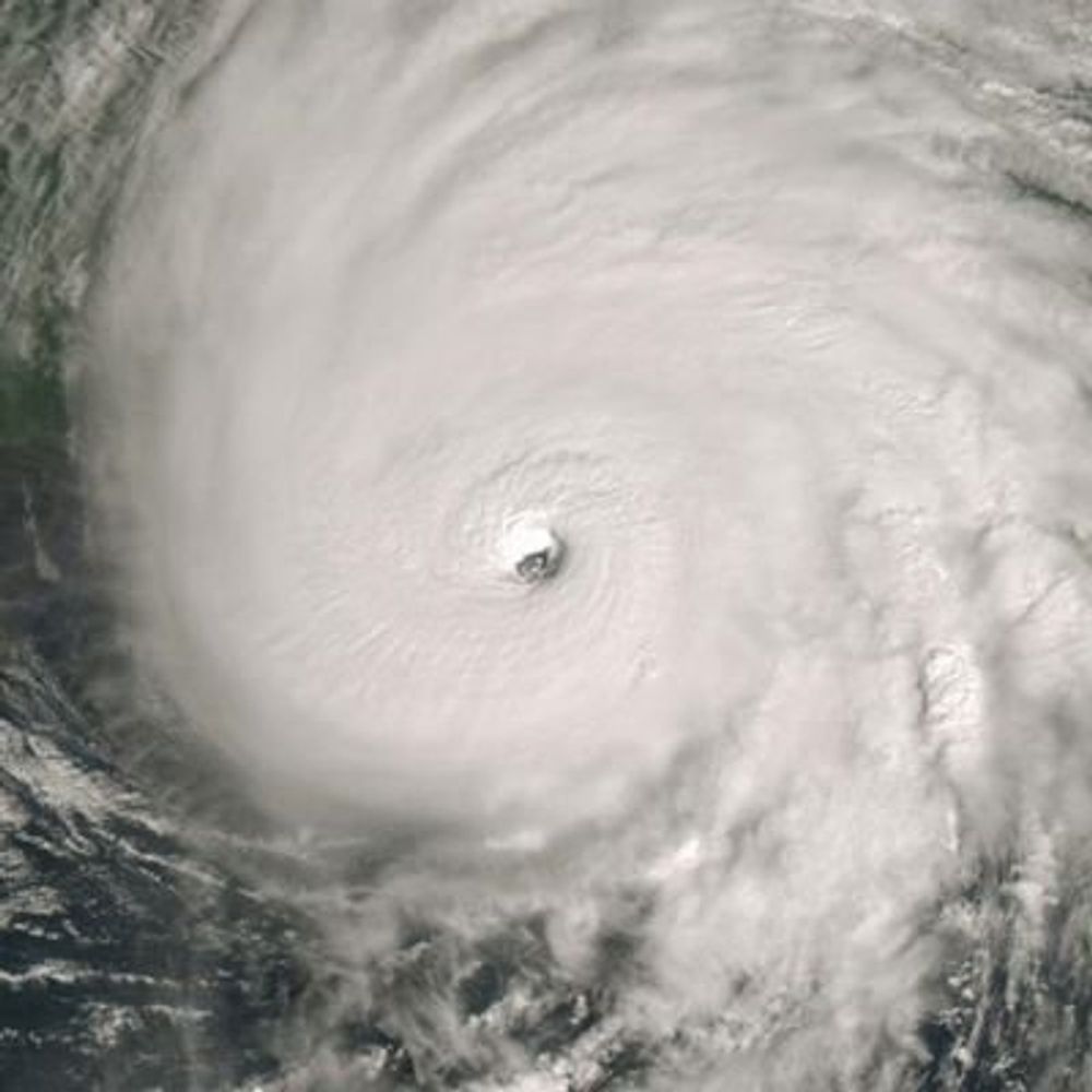
Take a look at all the sediments and minerals #Hurricane #Melissa kicked up just south of #Jamaica when it was a record breaking Category 5!
#wx
#wx
October 29, 2025 at 8:15 PM
Take a look at all the sediments and minerals #Hurricane #Melissa kicked up just south of #Jamaica when it was a record breaking Category 5!
#wx
#wx
Reposted by SRG SCIENCE

Here is a zoomed in radar version of 28 Oct showing #Melissa 's inner core evolution before #Jamaica landfall.
Radar evidence some type of fast eyewall replacement cycle, #ERC, occurred. Eye went from 10 n mi to 15 n mi on VDM fixes & more intensification occured after ERC.
Horrible for Jamaica 😞
Radar evidence some type of fast eyewall replacement cycle, #ERC, occurred. Eye went from 10 n mi to 15 n mi on VDM fixes & more intensification occured after ERC.
Horrible for Jamaica 😞
November 3, 2025 at 6:10 PM
Reposted by SRG SCIENCE
Invest #90W is a little bit ahead of schedule, with the system already getting an LLC together. Recent models are going incredibly bullish, not just wanting a CATEGORY 5 #SUPERTYPHOON, but one that could reach below 900mb! Those in the northern #Philippines need to watch this!


November 3, 2025 at 9:30 PM
Invest #90W is a little bit ahead of schedule, with the system already getting an LLC together. Recent models are going incredibly bullish, not just wanting a CATEGORY 5 #SUPERTYPHOON, but one that could reach below 900mb! Those in the northern #Philippines need to watch this!


Reposted by SRG SCIENCE

es ist herbts die atompilze schießen aus dem boden

November 3, 2025 at 7:09 AM
es ist herbts die atompilze schießen aus dem boden
Reposted by SRG SCIENCE

Subtropical Storm Karen forms in the Atlantic Ocean north of the Azores, becoming the eleventh named storm of the 2025 hurricane season.
A subtropical cyclone is a system that has both tropical and extratropical features.
A subtropical cyclone is a system that has both tropical and extratropical features.
October 10, 2025 at 7:53 PM
Subtropical Storm Karen forms in the Atlantic Ocean north of the Azores, becoming the eleventh named storm of the 2025 hurricane season.
A subtropical cyclone is a system that has both tropical and extratropical features.
A subtropical cyclone is a system that has both tropical and extratropical features.
Reposted by SRG SCIENCE

7 years ago today, Category 5 Hurricane #Michael made landfall along Florida's Gulf Coast. More imagery and details on the CIMSS Satellite Blog: cimss.ssec.wisc.edu/satellite-bl... #FLwx
October 11, 2025 at 2:17 AM
7 years ago today, Category 5 Hurricane #Michael made landfall along Florida's Gulf Coast. More imagery and details on the CIMSS Satellite Blog: cimss.ssec.wisc.edu/satellite-bl... #FLwx
Reposted by SRG SCIENCE
Fun neutercane in the middle of an occluded low northwest of the Azores.
NHC usually seems to feel better about a subtropical or tropical designation once cloud tops cool to -60C. We’re about 10C away from that level. 🐻⌚️
NHC usually seems to feel better about a subtropical or tropical designation once cloud tops cool to -60C. We’re about 10C away from that level. 🐻⌚️

October 9, 2025 at 6:06 PM
Fun neutercane in the middle of an occluded low northwest of the Azores.
NHC usually seems to feel better about a subtropical or tropical designation once cloud tops cool to -60C. We’re about 10C away from that level. 🐻⌚️
NHC usually seems to feel better about a subtropical or tropical designation once cloud tops cool to -60C. We’re about 10C away from that level. 🐻⌚️
Reposted by SRG SCIENCE

From Hurricane #Imelda today. Strong winds create a streaking effect on the ocean surface. Was about 65 kts here so this is hurricane force. Eventually upgraded to Cat 2 during the mission. Should pack a decent punch to Bermuda tonight.
October 1, 2025 at 8:23 PM
From Hurricane #Imelda today. Strong winds create a streaking effect on the ocean surface. Was about 65 kts here so this is hurricane force. Eventually upgraded to Cat 2 during the mission. Should pack a decent punch to Bermuda tonight.
Reposted by SRG SCIENCE
An elegant waltz occurs just off the East Coast of the US, as Hurricanes Humberto and Imelda put on a captivating performance.
September 30, 2025 at 11:37 PM
An elegant waltz occurs just off the East Coast of the US, as Hurricanes Humberto and Imelda put on a captivating performance.
Satellite animation of #Hurricane #Imelda (left) and Hurricane #Humberto (right).
#HurricaneHumberto was previously a category 5 storm. As of posting this, it is down to a category 1.
#hurricaneImelda is slowly intensifying while it pulls out to see. #Bermuda is in its path.
#HurricaneHumberto was previously a category 5 storm. As of posting this, it is down to a category 1.
#hurricaneImelda is slowly intensifying while it pulls out to see. #Bermuda is in its path.
September 30, 2025 at 11:44 PM
Satellite animation of #Hurricane #Imelda (left) and Hurricane #Humberto (right).
#HurricaneHumberto was previously a category 5 storm. As of posting this, it is down to a category 1.
#hurricaneImelda is slowly intensifying while it pulls out to see. #Bermuda is in its path.
#HurricaneHumberto was previously a category 5 storm. As of posting this, it is down to a category 1.
#hurricaneImelda is slowly intensifying while it pulls out to see. #Bermuda is in its path.
Reposted by SRG SCIENCE
Hurricane Gabrielle becomes a major storm.
This morning's view shows a few bursts of intense convection within Gabrielle's inner core.
This morning's view shows a few bursts of intense convection within Gabrielle's inner core.
September 22, 2025 at 3:17 PM
Hurricane Gabrielle becomes a major storm.
This morning's view shows a few bursts of intense convection within Gabrielle's inner core.
This morning's view shows a few bursts of intense convection within Gabrielle's inner core.
Reposted by SRG SCIENCE
Now a Category 4, #Gabrielle's satellite presentation continues to improve. Great time to watch the mesoscale loop as the sun goes down!
September 22, 2025 at 7:02 PM
Now a Category 4, #Gabrielle's satellite presentation continues to improve. Great time to watch the mesoscale loop as the sun goes down!
Reposted by SRG SCIENCE
Lightning flashes around the strong eye of a category 4 Hurricane Gabrielle.
September 22, 2025 at 11:19 PM
Lightning flashes around the strong eye of a category 4 Hurricane Gabrielle.

Reposted by SRG SCIENCE
Pretty neat radar evolution w/ #Gabrielle which rapidly intensified into a Cat 4 #hurricane today.
An eyewall replacement cycle occurred, but instead of the typical cycle of the inner replacing the outer eyewall, it appears the two eyewalls merged & did not interrupt continued intensification.
An eyewall replacement cycle occurred, but instead of the typical cycle of the inner replacing the outer eyewall, it appears the two eyewalls merged & did not interrupt continued intensification.
September 22, 2025 at 10:23 PM
Pretty neat radar evolution w/ #Gabrielle which rapidly intensified into a Cat 4 #hurricane today.
An eyewall replacement cycle occurred, but instead of the typical cycle of the inner replacing the outer eyewall, it appears the two eyewalls merged & did not interrupt continued intensification.
An eyewall replacement cycle occurred, but instead of the typical cycle of the inner replacing the outer eyewall, it appears the two eyewalls merged & did not interrupt continued intensification.
Reposted by SRG SCIENCE
A remarkable two-day time lapse of Super Typhoon Ragasa.
Over the next few days, Ragasa will continue it's trek west towards China.
Over the next few days, Ragasa will continue it's trek west towards China.
September 23, 2025 at 1:40 AM
A remarkable two-day time lapse of Super Typhoon Ragasa.
Over the next few days, Ragasa will continue it's trek west towards China.
Over the next few days, Ragasa will continue it's trek west towards China.
Reposted by SRG SCIENCE

Don't call it a come back...
The globe has awakened from it's hurricane slumber with 3 major hurricanes / super typhoons in 3 days! All three have been cat 4 and 5's with #Ragasa topping the list at 175 mph. #Gabrielle is peaking now so 140 may soon be upgraded.
The globe has awakened from it's hurricane slumber with 3 major hurricanes / super typhoons in 3 days! All three have been cat 4 and 5's with #Ragasa topping the list at 175 mph. #Gabrielle is peaking now so 140 may soon be upgraded.

September 23, 2025 at 1:36 AM
Don't call it a come back...
The globe has awakened from it's hurricane slumber with 3 major hurricanes / super typhoons in 3 days! All three have been cat 4 and 5's with #Ragasa topping the list at 175 mph. #Gabrielle is peaking now so 140 may soon be upgraded.
The globe has awakened from it's hurricane slumber with 3 major hurricanes / super typhoons in 3 days! All three have been cat 4 and 5's with #Ragasa topping the list at 175 mph. #Gabrielle is peaking now so 140 may soon be upgraded.
Reposted by SRG SCIENCE
Tropical Cyclone Kiko swirls north of the Hawai'i.
September 9, 2025 at 8:31 PM
Tropical Cyclone Kiko swirls north of the Hawai'i.