


Prof. Simon Carn
@simoncarn.bsky.social
Volcanologist @michigantech.bsky.social. Satellite-powered analysis of global #volcanic activity. #GreatLakes silent sports 🏃🏻♂️🚵🏻♂️⛷. Often buried in snow. 🇬🇧/🇺🇸
As of November 26, the SO₂ emitted by #HayliGubbi on Nov 23 has been sheared out into a near-continuous plume extending from East Africa to the central Pacific. SO₂ data from #NOAA-20 OMPS.

November 26, 2025 at 7:57 PM
As of November 26, the SO₂ emitted by #HayliGubbi on Nov 23 has been sheared out into a near-continuous plume extending from East Africa to the central Pacific. SO₂ data from #NOAA-20 OMPS.
Pre- and post-eruption visible imagery of #HayliGubbi from #Sentinel-2, showing tephra deposits and 2 new craters. The latter could be eruption vents and/or formed by post-eruptive subsidence. Looks like the pre-existing crater was enlarged by the eruption. @esa.int
November 25, 2025 at 3:45 PM
Pre- and post-eruption visible imagery of #HayliGubbi from #Sentinel-2, showing tephra deposits and 2 new craters. The latter could be eruption vents and/or formed by post-eruptive subsidence. Looks like the pre-existing crater was enlarged by the eruption. @esa.int
Thanks Tim. @planet.com imagery from Nov 24 show some subsidence in the southern half of the Erta Ale caldera after the #HayliGubbi eruption (plus widespread ash deposits).
November 24, 2025 at 5:29 PM
Thanks Tim. @planet.com imagery from Nov 24 show some subsidence in the southern half of the Erta Ale caldera after the #HayliGubbi eruption (plus widespread ash deposits).
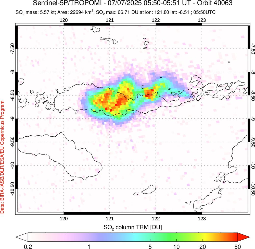
New #TROPOMI data on Nov 24 show higher total SO₂ emissions from #HayliGubbi (~0.2 Tg SO₂). Measurements on Nov 23 were likely impacted by the dense volcanic ash plume. Most of the SO₂ is spreading rapidly east in the subtropical jet stream, over the Arabian Sea towards NW India and Pakistan.

November 24, 2025 at 1:53 PM
New #TROPOMI data on Nov 24 show higher total SO₂ emissions from #HayliGubbi (~0.2 Tg SO₂). Measurements on Nov 23 were likely impacted by the dense volcanic ash plume. Most of the SO₂ is spreading rapidly east in the subtropical jet stream, over the Arabian Sea towards NW India and Pakistan.
Sentinel-5P #TROPOMI measurements at ~11:00 UTC show most of the SO₂ emissions from #HayliGubbi spreading east in the upper troposphere. Plume contains ~44 kilotons of SO₂ (~0.04 Tg).

November 23, 2025 at 5:53 PM
Sentinel-5P #TROPOMI measurements at ~11:00 UTC show most of the SO₂ emissions from #HayliGubbi spreading east in the upper troposphere. Plume contains ~44 kilotons of SO₂ (~0.04 Tg).
An explosive #eruption of Hayli Gubbi #volcano, located SE of Erta'Ale in the Afar Rift (Ethiopia), began at ~08:30 UTC on Nov 23. Eruption onset was fortuitously captured by a @planet.com overpass at 08:31 UTC. Hayli Gubbi has no record of Holocene eruptions. Toulouse VAAC reporting ash to ~15 km.


November 23, 2025 at 5:23 PM
An explosive #eruption of Hayli Gubbi #volcano, located SE of Erta'Ale in the Afar Rift (Ethiopia), began at ~08:30 UTC on Nov 23. Eruption onset was fortuitously captured by a @planet.com overpass at 08:31 UTC. Hayli Gubbi has no record of Holocene eruptions. Toulouse VAAC reporting ash to ~15 km.
Some stunning footage of ongoing pyroclastic flow activity at Semeru #volcano (Java, Indonesia). Screen capture shows a lightning strike at ~16:07 UTC. www.youtube.com/watch?v=Txgr...

November 19, 2025 at 4:06 PM
Some stunning footage of ongoing pyroclastic flow activity at Semeru #volcano (Java, Indonesia). Screen capture shows a lightning strike at ~16:07 UTC. www.youtube.com/watch?v=Txgr...
Satellite measurements on July 18 show continued SO₂ emissions from the erupting fissure in #Iceland and dispersion of SO₂ over #Greenland and the #Arctic Ocean.
July 18, 2025 at 7:24 PM
Satellite measurements on July 18 show continued SO₂ emissions from the erupting fissure in #Iceland and dispersion of SO₂ over #Greenland and the #Arctic Ocean.
Dispersion of #volcanic SO₂ from the latest #eruption on #Iceland's #Reykjanes peninsula (July 16), measured by the Sentinel-5P TROPOMI satellite instrument. SO₂ emissions have spread into north and west Iceland, impacting air quality (Icelandic Met Office). @esa.int
July 18, 2025 at 7:15 PM
Dispersion of #volcanic SO₂ from the latest #eruption on #Iceland's #Reykjanes peninsula (July 16), measured by the Sentinel-5P TROPOMI satellite instrument. SO₂ emissions have spread into north and west Iceland, impacting air quality (Icelandic Met Office). @esa.int
Thanks Fred. Impressive plume but low SO₂ loading (~6 kt or 0.006 Tg); an order of magnitude lower than the June 17 eruption of #Lewotobi.
July 8, 2025 at 7:19 PM
Thanks Fred. Impressive plume but low SO₂ loading (~6 kt or 0.006 Tg); an order of magnitude lower than the June 17 eruption of #Lewotobi.
Satellite imagery of nighttime lights using the NOAA-20/VIIRS Day/Night Band ('visible image at night') shows areas of Spain and Portugal still affected by power outages overnight on April 28-29. Images from NASA Worldview. @thenasaearth.bsky.social @noaa.gov
April 29, 2025 at 3:54 PM
Satellite imagery of nighttime lights using the NOAA-20/VIIRS Day/Night Band ('visible image at night') shows areas of Spain and Portugal still affected by power outages overnight on April 28-29. Images from NASA Worldview. @thenasaearth.bsky.social @noaa.gov
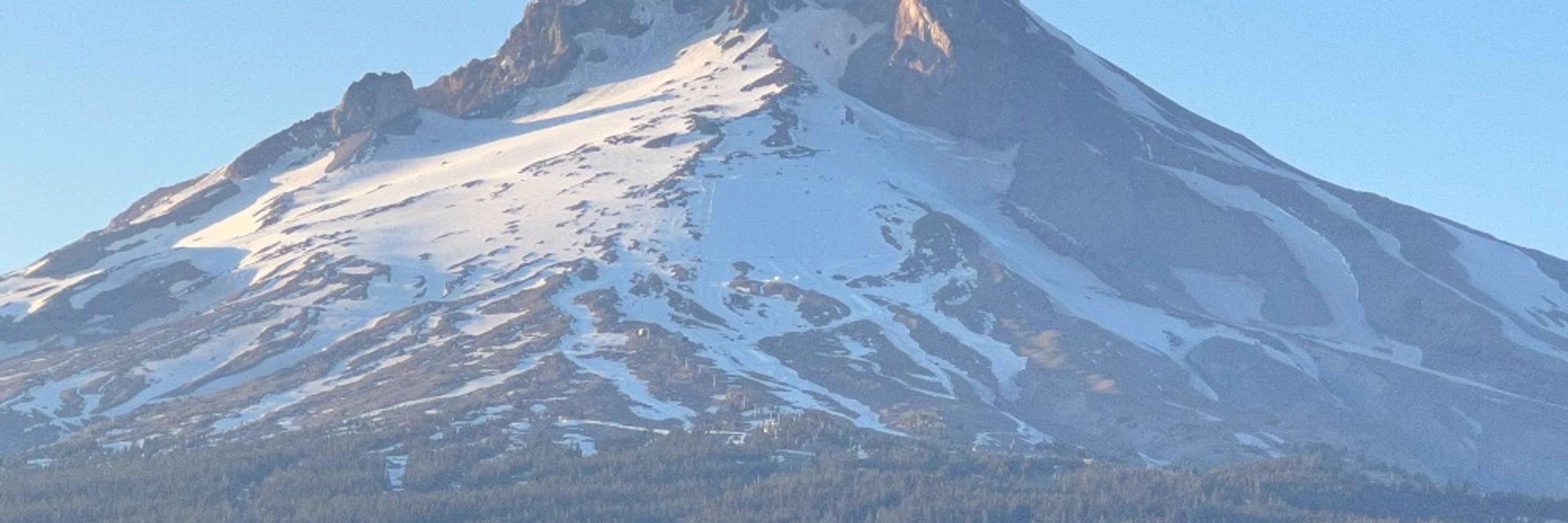
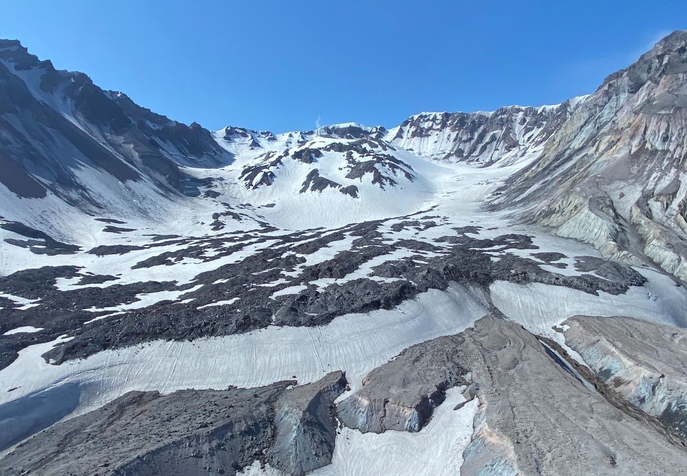
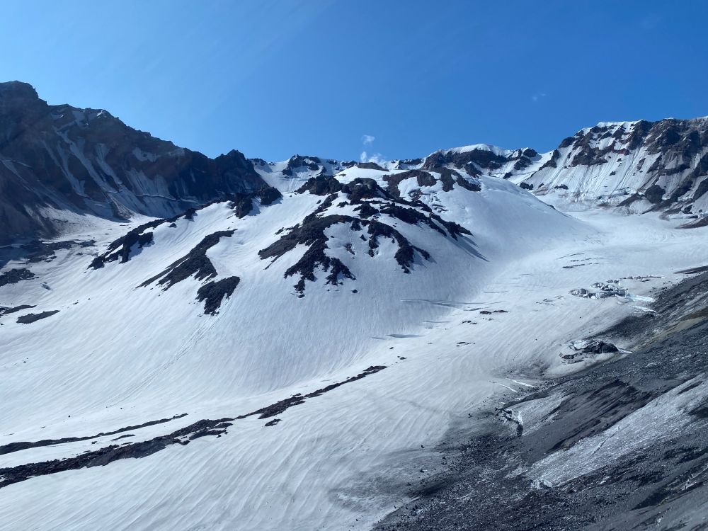
The world's youngest mountain glacier - Crater Glacier at Mount St. Helens #volcano (WA, USA) - formed in 1996 in the amphitheater produced by the May 1980 eruption. The glacier flows around lava domes erupted in 1980-86 and 2004-08. Photos taken in 2023. #WorldGlacierDay 🧪🌋
March 21, 2025 at 4:54 PM
The world's youngest mountain glacier - Crater Glacier at Mount St. Helens #volcano (WA, USA) - formed in 1996 in the amphitheater produced by the May 1980 eruption. The glacier flows around lava domes erupted in 1980-86 and 2004-08. Photos taken in 2023. #WorldGlacierDay 🧪🌋
When Spurr last erupted in 1992, volcanic ash & gas clouds (a potential aviation hazard) drifted south over the Pacific NW & Upper Midwest. A fully functional USGS & NOAA is needed to monitor such events & mitigate their impacts. NASA/NOAA satellite data also critical for tracking volcanic clouds.
March 12, 2025 at 10:48 PM
When Spurr last erupted in 1992, volcanic ash & gas clouds (a potential aviation hazard) drifted south over the Pacific NW & Upper Midwest. A fully functional USGS & NOAA is needed to monitor such events & mitigate their impacts. NASA/NOAA satellite data also critical for tracking volcanic clouds.
Satellite imagery from @planet.com shows increased steaming in the summit caldera of Fentale volcano (Ethiopia) in the last week. Emissions appear confined to topographic lows - perhaps a meteorological effect (temperature inversion?). @davidmpyle.bsky.social @volckaren.bsky.social 🧪
January 20, 2025 at 12:38 AM
Satellite imagery from @planet.com shows increased steaming in the summit caldera of Fentale volcano (Ethiopia) in the last week. Emissions appear confined to topographic lows - perhaps a meteorological effect (temperature inversion?). @davidmpyle.bsky.social @volckaren.bsky.social 🧪
#Volcanic SO₂ plume from #Kanlaon #volcano captured and entrained by Super Typhoon #Man-yi (#Pepito) during its passage through the #Philippines. Data from the #geostationary GK-2B GEMS instrument.
November 19, 2024 at 5:51 AM
#Volcanic SO₂ plume from #Kanlaon #volcano captured and entrained by Super Typhoon #Man-yi (#Pepito) during its passage through the #Philippines. Data from the #geostationary GK-2B GEMS instrument.
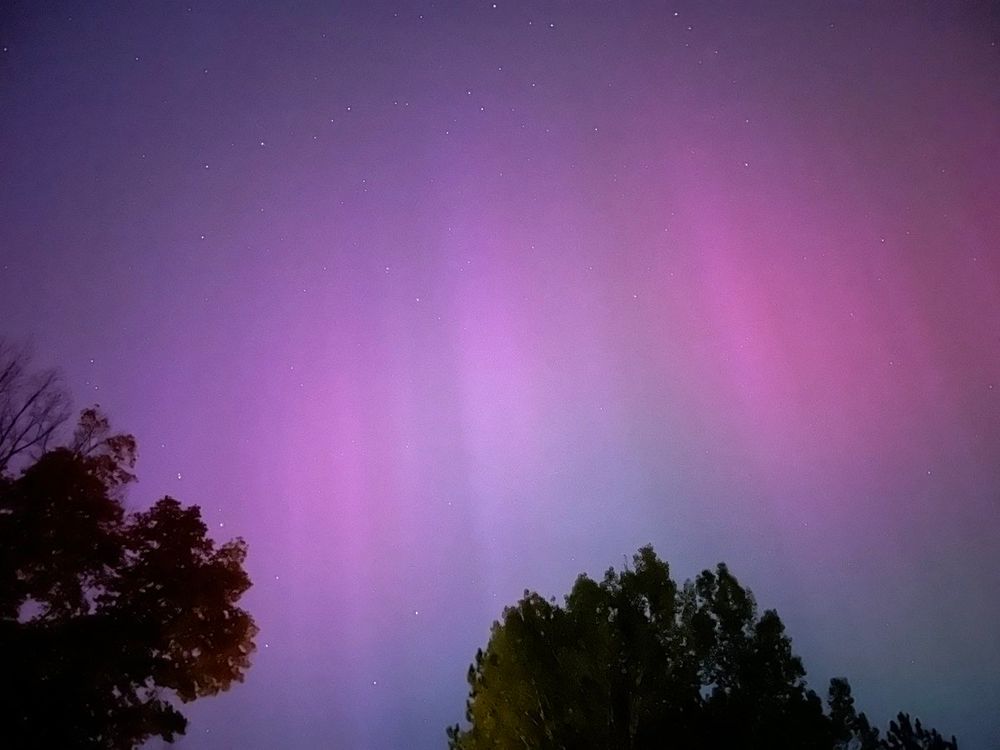
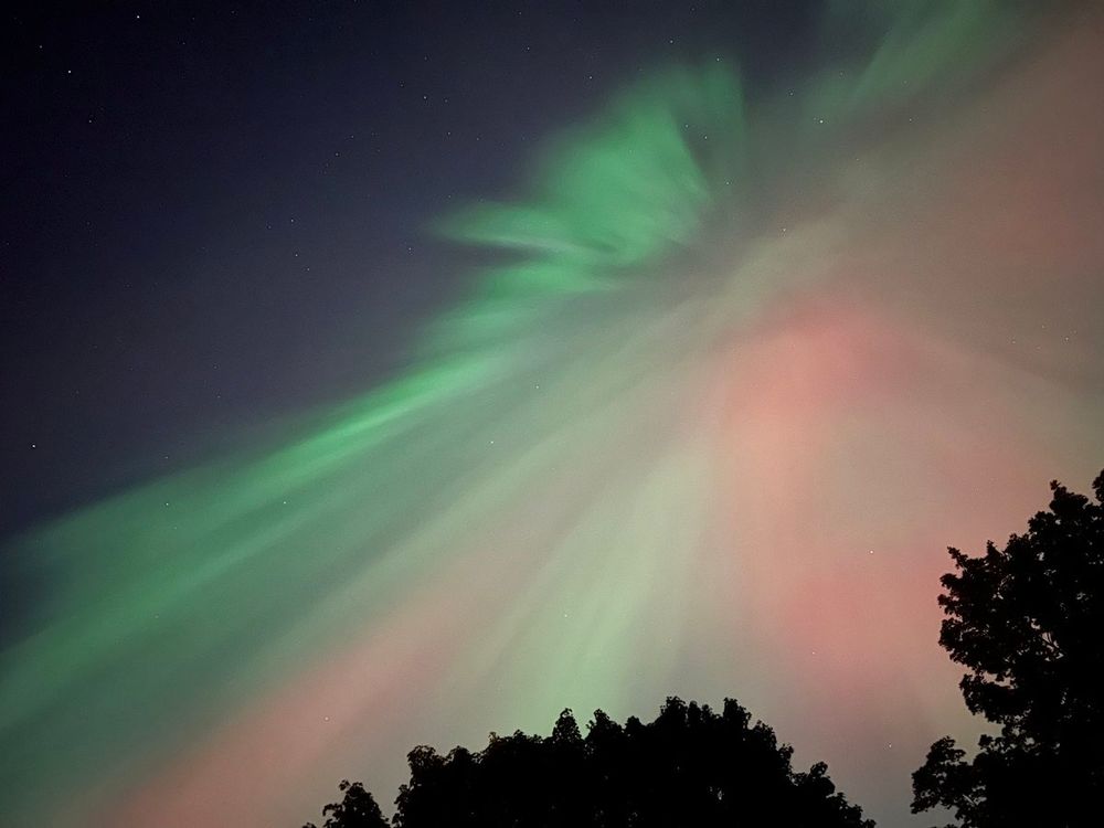
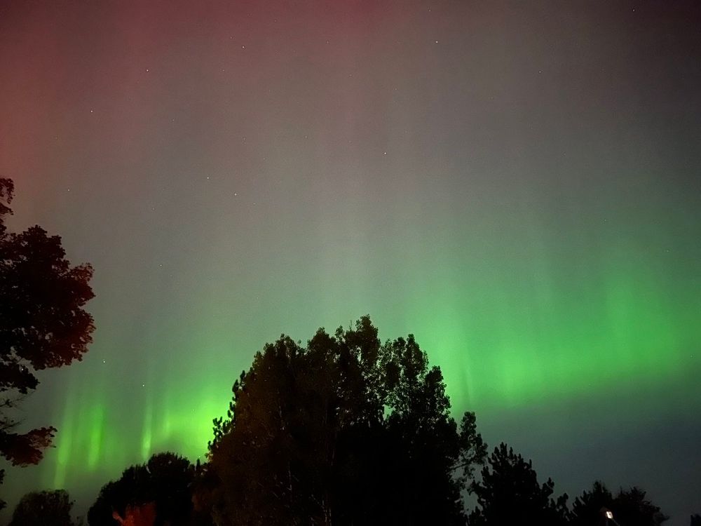
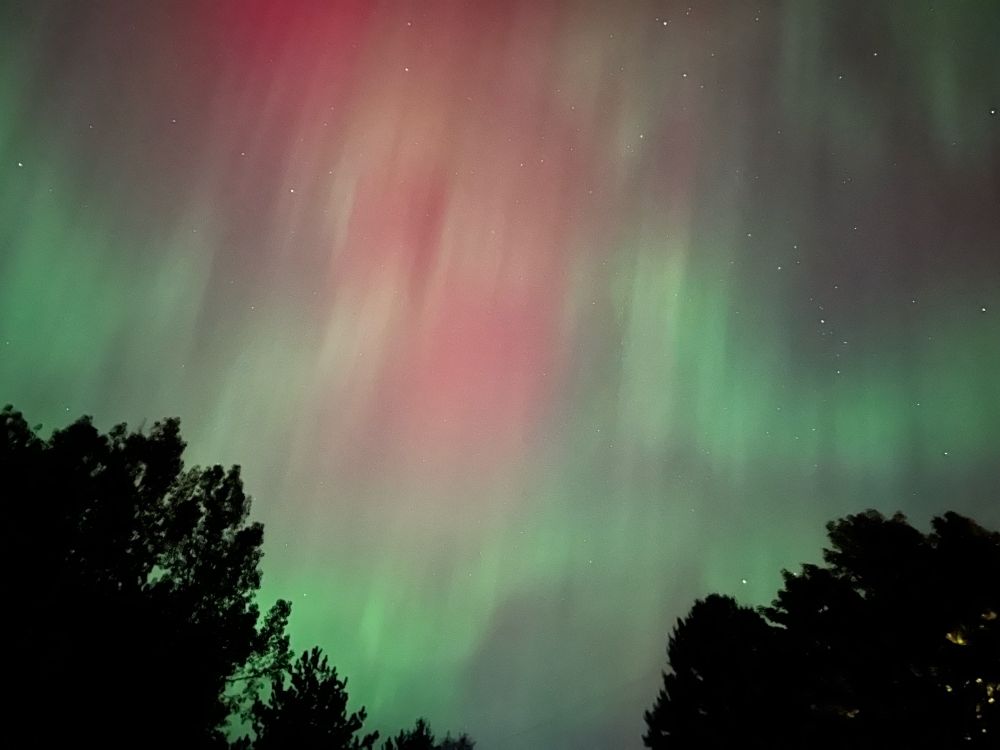
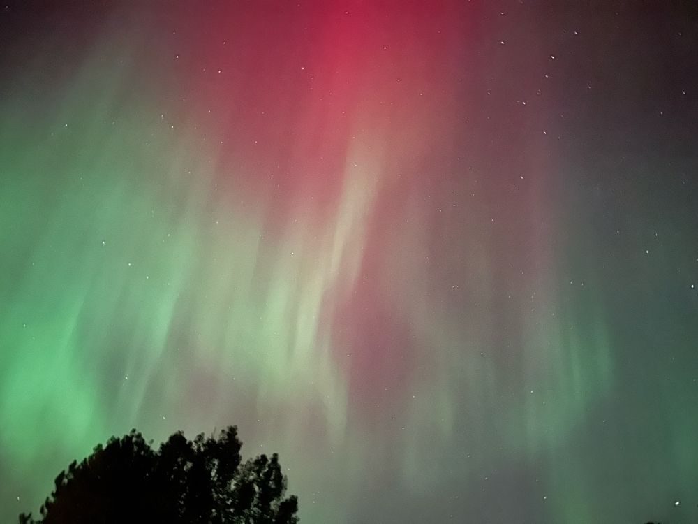
Evolution of colors in tonight’s #aurora over Hancock, #Michigan. @Upper Peninsula @NWSMarquette @TamithaSkov #northernlights #geomagneticstorm

November 16, 2024 at 10:20 PM
Evolution of colors in tonight’s #aurora over Hancock, #Michigan. @Upper Peninsula @NWSMarquette @TamithaSkov #northernlights #geomagneticstorm
October 8, 2024 at 4:19 AM
Another batch of #volcanic SO₂ en route to the #UK/#Ireland, courtesy of the latest #eruption on #Iceland's #Reykjanes peninsula. Might cause some local #AirQuality impacts in the coming days. @eddy_weather @ScottishEPA
SO₂ data: @NOAA/@NASA @JPSSProgram #NOAA20-#OMPS
SO₂ data: @NOAA/@NASA @JPSSProgram #NOAA20-#OMPS
November 16, 2024 at 10:20 PM
Another batch of #volcanic SO₂ en route to the #UK/#Ireland, courtesy of the latest #eruption on #Iceland's #Reykjanes peninsula. Might cause some local #AirQuality impacts in the coming days. @eddy_weather @ScottishEPA
SO₂ data: @NOAA/@NASA @JPSSProgram #NOAA20-#OMPS
SO₂ data: @NOAA/@NASA @JPSSProgram #NOAA20-#OMPS
Longer sequence of hourly #GEMS data (daytime only) showing SO₂ emissions from the June 3 #Kanlaon #eruption. On June 5, the upper tropospheric SO₂ cloud was moving west over #SriLanka and S. #India, whilst SO₂ at lower altitudes is dispersing over the southern #Philippines.
November 16, 2024 at 10:31 PM
The largest #eruption on record of #Kanlaon/#Canlaon #volcano (#Philippines) on June 3 produced an upper tropospheric SO₂ cloud (~0.05 Tg SO₂), seen here from #geostationary orbit by #SouthKorea's UV #GK2B #GEMS sensor.
@phivolcs_dost @News5PH @nababaha
@phivolcs_dost @News5PH @nababaha
November 16, 2024 at 10:20 PM
The largest #eruption on record of #Kanlaon/#Canlaon #volcano (#Philippines) on June 3 produced an upper tropospheric SO₂ cloud (~0.05 Tg SO₂), seen here from #geostationary orbit by #SouthKorea's UV #GK2B #GEMS sensor.
@phivolcs_dost @News5PH @nababaha
@phivolcs_dost @News5PH @nababaha
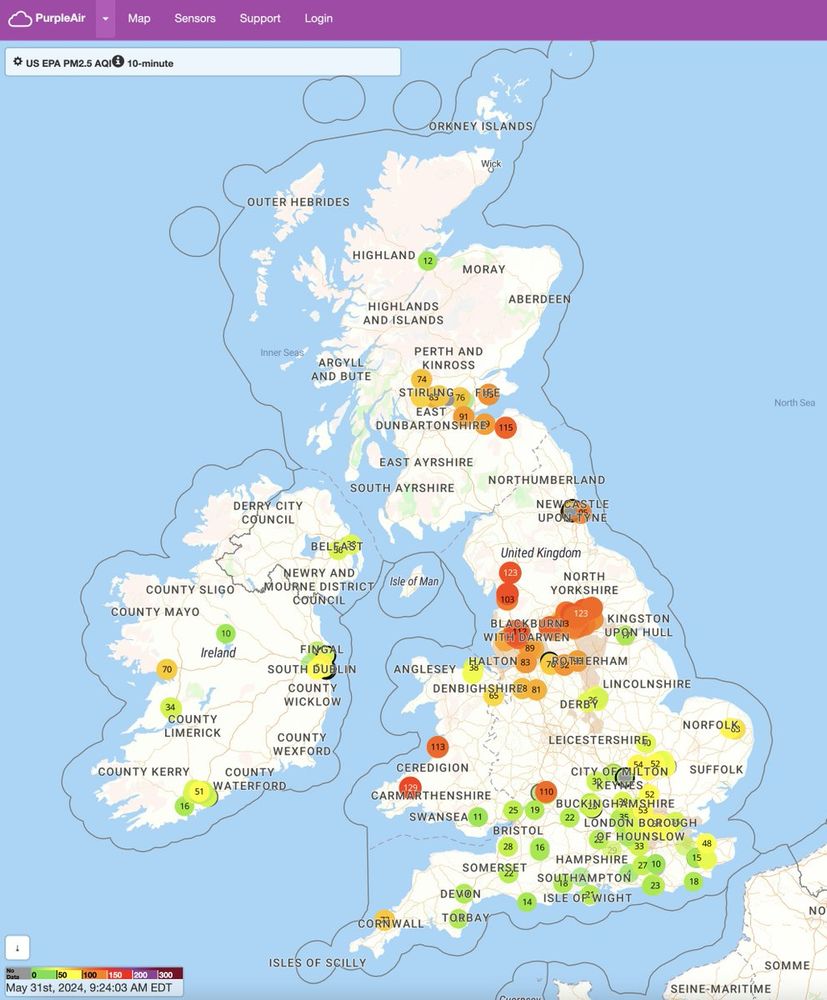
The #volcanic SO₂ (and derived sulfate aerosol) from #Iceland seems to be impacting surface #AirQuality over the northern #UK today.
L: #TROPOMI data shows SO₂ plume at 11:50 UT
R: map shows data from the @ThePurpleAir...
L: #TROPOMI data shows SO₂ plume at 11:50 UT
R: map shows data from the @ThePurpleAir...
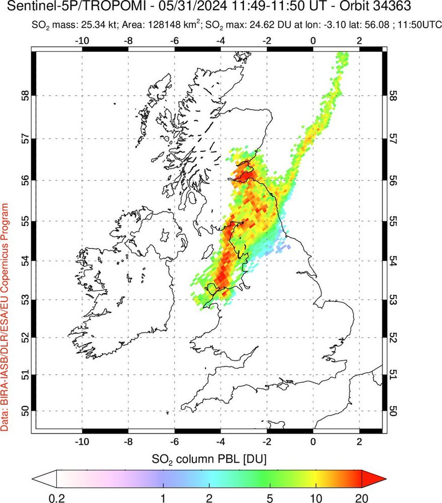
November 16, 2024 at 10:43 PM
The #volcanic SO₂ (and derived sulfate aerosol) from #Iceland seems to be impacting surface #AirQuality over the northern #UK today.
L: #TROPOMI data shows SO₂ plume at 11:50 UT
R: map shows data from the @ThePurpleAir...
L: #TROPOMI data shows SO₂ plume at 11:50 UT
R: map shows data from the @ThePurpleAir...
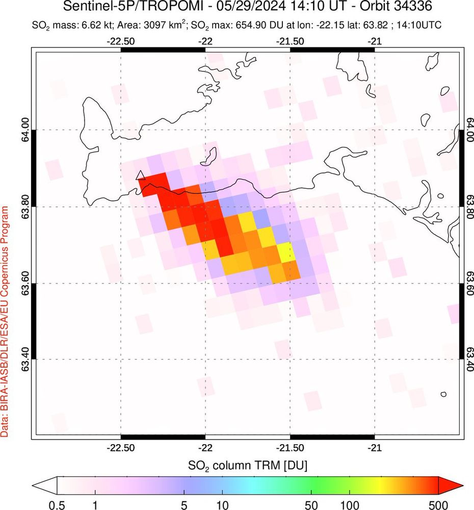
Consecutive orbits of #TROPOMI data on May 30 show ongoing SO₂ emissions from the Sundhnúksgíga #eruption. The SO₂ plume emitted on May 29 is now drifting towards NW #Scotland & SO₂ columns in this cloud remain quite high (~200 DU). Might create some visible haze. @EIlyinskaya
November 16, 2024 at 10:31 PM
First #Sentinel5P #TROPOMI overpass ~1.3 hours after the onset of today's #eruption on #Iceland's #Reykjanes peninsula shows very high SO₂ column amounts in plume spreading SE. Est. SO₂ emission rate is ~1400 kg/s (~120,000 tons/day). @Vedurstofan @CopernicusEU @rockhardIES
November 16, 2024 at 10:20 PM
First #Sentinel5P #TROPOMI overpass ~1.3 hours after the onset of today's #eruption on #Iceland's #Reykjanes peninsula shows very high SO₂ column amounts in plume spreading SE. Est. SO₂ emission rate is ~1400 kg/s (~120,000 tons/day). @Vedurstofan @CopernicusEU @rockhardIES
SO₂ emissions from the April 16 #eruption of #Ruang #volcano (#Indonesia) measured with hourly cadence by #SouthKorea's #geostationary UV GK-2B #GEMS sensor. Relatively low SO₂ amounts detected so far. @PVMBG_ @id_magma @andrewcraigtupp
November 16, 2024 at 10:21 PM
SO₂ emissions from the April 16 #eruption of #Ruang #volcano (#Indonesia) measured with hourly cadence by #SouthKorea's #geostationary UV GK-2B #GEMS sensor. Relatively low SO₂ amounts detected so far. @PVMBG_ @id_magma @andrewcraigtupp