


Rodney Barney
@rcbstormpost.bsky.social
Posting tidbits of #NLwx | Meteorologist | Gander, Newfoundland and Labrador

Temps tanking now, but not before the windy, mild #NLwx took a serious bite out of the snowpack.
#GanderWest: 33 cm on ground yesterday morning; just 8 cm average this afternoon, with many bare patches.
Goose Bay #YYR: 67 cm down to 35 cm in 24 hrs.
Lots of double-digit highs!
#GanderWest: 33 cm on ground yesterday morning; just 8 cm average this afternoon, with many bare patches.
Goose Bay #YYR: 67 cm down to 35 cm in 24 hrs.
Lots of double-digit highs!


December 20, 2025 at 7:21 PM
Temps tanking now, but not before the windy, mild #NLwx took a serious bite out of the snowpack.
#GanderWest: 33 cm on ground yesterday morning; just 8 cm average this afternoon, with many bare patches.
Goose Bay #YYR: 67 cm down to 35 cm in 24 hrs.
Lots of double-digit highs!
#GanderWest: 33 cm on ground yesterday morning; just 8 cm average this afternoon, with many bare patches.
Goose Bay #YYR: 67 cm down to 35 cm in 24 hrs.
Lots of double-digit highs!

Snowfall totals and more data in the full summary of our latest #NLwx bomb: weather.gc.ca/warnings/wea....
Reports also indicate significant snow in the Corner Brook area, but no empirical data received yet.
Reports also indicate significant snow in the Corner Brook area, but no empirical data received yet.

December 16, 2025 at 4:08 PM
Snowfall totals and more data in the full summary of our latest #NLwx bomb: weather.gc.ca/warnings/wea....
Reports also indicate significant snow in the Corner Brook area, but no empirical data received yet.
Reports also indicate significant snow in the Corner Brook area, but no empirical data received yet.

Happy cleanup morning!
Event total snowfall 35.3 cm in #GanderWest since Sunday night — split between two rounds, with 1.8 mm rain/freezing rain in between. Snowfall 20.5 cm from the second round last night.
More numbers later...
#nlwx
Event total snowfall 35.3 cm in #GanderWest since Sunday night — split between two rounds, with 1.8 mm rain/freezing rain in between. Snowfall 20.5 cm from the second round last night.
More numbers later...
#nlwx


December 16, 2025 at 11:28 AM
Happy cleanup morning!
Event total snowfall 35.3 cm in #GanderWest since Sunday night — split between two rounds, with 1.8 mm rain/freezing rain in between. Snowfall 20.5 cm from the second round last night.
More numbers later...
#nlwx
Event total snowfall 35.3 cm in #GanderWest since Sunday night — split between two rounds, with 1.8 mm rain/freezing rain in between. Snowfall 20.5 cm from the second round last night.
More numbers later...
#nlwx
Obligatory pic of glass gone bottom up.
For Gander #YQX, official minimum sea level pressure 949.7 mb this evening marks the lowest since Feb 9, 1964 (when the all-time low of 946.9 mb occurred). Data since 1959.
Rebound will be swift: 50 mb rise next 12 hrs. Thus, wind!
#nlwx
For Gander #YQX, official minimum sea level pressure 949.7 mb this evening marks the lowest since Feb 9, 1964 (when the all-time low of 946.9 mb occurred). Data since 1959.
Rebound will be swift: 50 mb rise next 12 hrs. Thus, wind!
#nlwx

December 16, 2025 at 12:41 AM
Central pressure at about 960 mb as centre just comes onto land near McCallum around 1800 UTC (2:30 PM NST). About 16 mb of intensification in the past six hours alone. #nlwx

December 15, 2025 at 6:40 PM
Central pressure at about 960 mb as centre just comes onto land near McCallum around 1800 UTC (2:30 PM NST). About 16 mb of intensification in the past six hours alone. #nlwx
Snowfall 14.5 cm through 11am in #GanderWest, with ice pellets now into the mix. Getting more dense with water equivalent 15.8 mm. #nlwx

December 15, 2025 at 2:37 PM
Snowfall 14.5 cm through 11am in #GanderWest, with ice pellets now into the mix. Getting more dense with water equivalent 15.8 mm. #nlwx
Measuring 9.4 cm of snow through 7 am in #GanderWest (water equivalent 7.9 mm putting the average snow to liquid ratio near 12 to 1 for what has fallen so far).
Airport reports as of 6:30 am included 9 cm at St. John's #YTT – now over to rain, and 11 cm at Deer Lake #YDF.
#nlwx
Airport reports as of 6:30 am included 9 cm at St. John's #YTT – now over to rain, and 11 cm at Deer Lake #YDF.
#nlwx


December 15, 2025 at 10:50 AM
Measuring 9.4 cm of snow through 7 am in #GanderWest (water equivalent 7.9 mm putting the average snow to liquid ratio near 12 to 1 for what has fallen so far).
Airport reports as of 6:30 am included 9 cm at St. John's #YTT – now over to rain, and 11 cm at Deer Lake #YDF.
#nlwx
Airport reports as of 6:30 am included 9 cm at St. John's #YTT – now over to rain, and 11 cm at Deer Lake #YDF.
#nlwx
A number of alerts into the orange tier, meaning prepare for a more impactful event—like longer-duration power outages due to wind, or for areas where snow involved, a longer cleanup.
Also, a coastal flooding statement for parts of the NE coast.
www.weather.gc.ca?center=48.82... #nlwx
Also, a coastal flooding statement for parts of the NE coast.
www.weather.gc.ca?center=48.82... #nlwx


December 14, 2025 at 9:07 PM
A number of alerts into the orange tier, meaning prepare for a more impactful event—like longer-duration power outages due to wind, or for areas where snow involved, a longer cleanup.
Also, a coastal flooding statement for parts of the NE coast.
www.weather.gc.ca?center=48.82... #nlwx
Also, a coastal flooding statement for parts of the NE coast.
www.weather.gc.ca?center=48.82... #nlwx


December 14, 2025 at 7:13 PM
4/4 Winds peak on the backside of the system, with exposed coastal gusts potentially 130+ km/h Monday night. Sustained hurricane-force offshore (models showing a sting jet signal).
Conditions rapidly improve Tuesday for all as the system quickly departs. #nlwx
Conditions rapidly improve Tuesday for all as the system quickly departs. #nlwx

December 13, 2025 at 9:20 PM
4/4 Winds peak on the backside of the system, with exposed coastal gusts potentially 130+ km/h Monday night. Sustained hurricane-force offshore (models showing a sting jet signal).
Conditions rapidly improve Tuesday for all as the system quickly departs. #nlwx
Conditions rapidly improve Tuesday for all as the system quickly departs. #nlwx
3/4 Further east (incl. St. John’s metro), much lower snowfall, then rain, followed by a dry slot and a spell of very mild air. Snow resumes from the storm’s wraparound as it pulls away, with temperatures falling again. #nlwx

December 13, 2025 at 9:19 PM
3/4 Further east (incl. St. John’s metro), much lower snowfall, then rain, followed by a dry slot and a spell of very mild air. Snow resumes from the storm’s wraparound as it pulls away, with temperatures falling again. #nlwx
2/4 Significant snow likely for central & western parts of the island. GFW and areas just west favoured for heaviest main-system snowfall, with the west coast seeing additional accums from post-storm squalls. #Gander may get briefly dry-slotted, tempering totals somewhat. #nlwx

December 13, 2025 at 9:19 PM
1/4 Beginning to see convergence among the models on the Monday storm track (especially if we discount the NAM/JMA, which typically aren’t leaned on for #nlwx). Low tracks over or near Fortune Bay while undergoing explosive deepening, then departs via the NE coast.
December 13, 2025 at 9:18 PM
1/4 Beginning to see convergence among the models on the Monday storm track (especially if we discount the NAM/JMA, which typically aren’t leaned on for #nlwx). Low tracks over or near Fortune Bay while undergoing explosive deepening, then departs via the NE coast.
Snowy conditions in #Labrador; highest 24-hour totals over southeastern areas (thru 10am AST / 10:30 am NST):
20.5 cm (L'Anse au Loup);
20.4 cm (Blanc-Sablon #YBX);
17.8 cm (Goose Bay #YYR);
5.0 cm (Churchill Falls).
www.gov.nl.ca/ti/roads/cam... #nlwx
20.5 cm (L'Anse au Loup);
20.4 cm (Blanc-Sablon #YBX);
17.8 cm (Goose Bay #YYR);
5.0 cm (Churchill Falls).
www.gov.nl.ca/ti/roads/cam... #nlwx


December 12, 2025 at 2:32 PM
Snowy conditions in #Labrador; highest 24-hour totals over southeastern areas (thru 10am AST / 10:30 am NST):
20.5 cm (L'Anse au Loup);
20.4 cm (Blanc-Sablon #YBX);
17.8 cm (Goose Bay #YYR);
5.0 cm (Churchill Falls).
www.gov.nl.ca/ti/roads/cam... #nlwx
20.5 cm (L'Anse au Loup);
20.4 cm (Blanc-Sablon #YBX);
17.8 cm (Goose Bay #YYR);
5.0 cm (Churchill Falls).
www.gov.nl.ca/ti/roads/cam... #nlwx
Remnants of west coast snow squalls making their way across to #Gander.
Looking incredibly wintry considering the ground was bare a week ago. Snowfall 54 cm over the past 7 days. ❄️
weather.cod.edu/satrad/?parm... #nlwx
Looking incredibly wintry considering the ground was bare a week ago. Snowfall 54 cm over the past 7 days. ❄️
weather.cod.edu/satrad/?parm... #nlwx


December 9, 2025 at 7:50 PM
Remnants of west coast snow squalls making their way across to #Gander.
Looking incredibly wintry considering the ground was bare a week ago. Snowfall 54 cm over the past 7 days. ❄️
weather.cod.edu/satrad/?parm... #nlwx
Looking incredibly wintry considering the ground was bare a week ago. Snowfall 54 cm over the past 7 days. ❄️
weather.cod.edu/satrad/?parm... #nlwx
Fresh and fluffy 11.9 cm of snow in #GanderWest last night for the latest CoCoRaHS entry; water equiv just 7.6 mm (snow:liquid ratio ~16:1).
Other totals yesterday/last night:
20.0 cm (Terra Nova);
19.5 cm (St. Alban's);
15.0 cm (St. John's #YYT).
Strong winds observed on parts of the coast. #nlwx
Other totals yesterday/last night:
20.0 cm (Terra Nova);
19.5 cm (St. Alban's);
15.0 cm (St. John's #YYT).
Strong winds observed on parts of the coast. #nlwx

December 9, 2025 at 12:00 PM
Fresh and fluffy 11.9 cm of snow in #GanderWest last night for the latest CoCoRaHS entry; water equiv just 7.6 mm (snow:liquid ratio ~16:1).
Other totals yesterday/last night:
20.0 cm (Terra Nova);
19.5 cm (St. Alban's);
15.0 cm (St. John's #YYT).
Strong winds observed on parts of the coast. #nlwx
Other totals yesterday/last night:
20.0 cm (Terra Nova);
19.5 cm (St. Alban's);
15.0 cm (St. John's #YYT).
Strong winds observed on parts of the coast. #nlwx
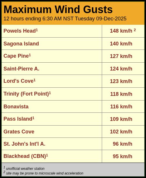
Winds quickly ramping up around the intensifying storm centre.
Peak gusts through 9 pm:
124 km/h (Saint-Pierre);
124 km/h (Sagona Island);
121 km/h (Trepassey - Powels Head);
109 km/h (Pass Island);
103 km/h (Cape Pine).
#nlwx
Peak gusts through 9 pm:
124 km/h (Saint-Pierre);
124 km/h (Sagona Island);
121 km/h (Trepassey - Powels Head);
109 km/h (Pass Island);
103 km/h (Cape Pine).
#nlwx

December 9, 2025 at 12:34 AM
Winds quickly ramping up around the intensifying storm centre.
Peak gusts through 9 pm:
124 km/h (Saint-Pierre);
124 km/h (Sagona Island);
121 km/h (Trepassey - Powels Head);
109 km/h (Pass Island);
103 km/h (Cape Pine).
#nlwx
Peak gusts through 9 pm:
124 km/h (Saint-Pierre);
124 km/h (Sagona Island);
121 km/h (Trepassey - Powels Head);
109 km/h (Pass Island);
103 km/h (Cape Pine).
#nlwx
Might be good time to do at least a rudimentary cleanup on the NE Avalon with backedge of first impulse going through.
Slice of milder air just south with 2°C at Middle Pond, 5°C at Trepassey, 3°C at Point May.
Also already gusting 104 km/h at Powels Head (Trepassey). #nlwx
Slice of milder air just south with 2°C at Middle Pond, 5°C at Trepassey, 3°C at Point May.
Also already gusting 104 km/h at Powels Head (Trepassey). #nlwx
December 8, 2025 at 11:30 PM
Might be good time to do at least a rudimentary cleanup on the NE Avalon with backedge of first impulse going through.
Slice of milder air just south with 2°C at Middle Pond, 5°C at Trepassey, 3°C at Point May.
Also already gusting 104 km/h at Powels Head (Trepassey). #nlwx
Slice of milder air just south with 2°C at Middle Pond, 5°C at Trepassey, 3°C at Point May.
Also already gusting 104 km/h at Powels Head (Trepassey). #nlwx
To those who mark the occasion: happy week-with-earliest-sunsets.
The evening-light comeback begins next week. 🌇
www.timeanddate.com #nlwx
The evening-light comeback begins next week. 🌇
www.timeanddate.com #nlwx

December 8, 2025 at 7:43 PM
To those who mark the occasion: happy week-with-earliest-sunsets.
The evening-light comeback begins next week. 🌇
www.timeanddate.com #nlwx
The evening-light comeback begins next week. 🌇
www.timeanddate.com #nlwx
Marion Bridge radar showing circulation centre driving the heaviest snow just off Cape Breton. The 996 mb centre is commencing bombogenesis, forecast to deepen by 40 mb to 956 mb in 24 hours as its track takes it across Placentia Bay tonight before moving away over the Atlantic. #nlwx
December 8, 2025 at 6:26 PM
Marion Bridge radar showing circulation centre driving the heaviest snow just off Cape Breton. The 996 mb centre is commencing bombogenesis, forecast to deepen by 40 mb to 956 mb in 24 hours as its track takes it across Placentia Bay tonight before moving away over the Atlantic. #nlwx
View from NOAA-20 VIRRS just after noon today showing yesterday's wind maker racing away as a ~960 mb low over the mid Atlantic.
Clear view of a cold and mostly snow-covered island in its wake (though still some bare ground still holding over the SE Avalon).
#nlwx
Clear view of a cold and mostly snow-covered island in its wake (though still some bare ground still holding over the SE Avalon).
#nlwx

December 6, 2025 at 7:52 PM
View from NOAA-20 VIRRS just after noon today showing yesterday's wind maker racing away as a ~960 mb low over the mid Atlantic.
Clear view of a cold and mostly snow-covered island in its wake (though still some bare ground still holding over the SE Avalon).
#nlwx
Clear view of a cold and mostly snow-covered island in its wake (though still some bare ground still holding over the SE Avalon).
#nlwx
