


Rodney Barney
@rcbstormpost.bsky.social
Posting tidbits of #NLwx | Meteorologist | Gander, Newfoundland and Labrador
Remnants of west coast snow squalls making their way across to #Gander.
Looking incredibly wintry considering the ground was bare a week ago. Snowfall 54 cm over the past 7 days. ❄️
weather.cod.edu/satrad/?parm... #nlwx
Looking incredibly wintry considering the ground was bare a week ago. Snowfall 54 cm over the past 7 days. ❄️
weather.cod.edu/satrad/?parm... #nlwx


December 9, 2025 at 7:50 PM
Remnants of west coast snow squalls making their way across to #Gander.
Looking incredibly wintry considering the ground was bare a week ago. Snowfall 54 cm over the past 7 days. ❄️
weather.cod.edu/satrad/?parm... #nlwx
Looking incredibly wintry considering the ground was bare a week ago. Snowfall 54 cm over the past 7 days. ❄️
weather.cod.edu/satrad/?parm... #nlwx
Fresh and fluffy 11.9 cm of snow in #GanderWest last night for the latest CoCoRaHS entry; water equiv just 7.6 mm (snow:liquid ratio ~16:1).
Other totals yesterday/last night:
20.0 cm (Terra Nova);
19.5 cm (St. Alban's);
15.0 cm (St. John's #YYT).
Strong winds observed on parts of the coast. #nlwx
Other totals yesterday/last night:
20.0 cm (Terra Nova);
19.5 cm (St. Alban's);
15.0 cm (St. John's #YYT).
Strong winds observed on parts of the coast. #nlwx

December 9, 2025 at 12:00 PM
Fresh and fluffy 11.9 cm of snow in #GanderWest last night for the latest CoCoRaHS entry; water equiv just 7.6 mm (snow:liquid ratio ~16:1).
Other totals yesterday/last night:
20.0 cm (Terra Nova);
19.5 cm (St. Alban's);
15.0 cm (St. John's #YYT).
Strong winds observed on parts of the coast. #nlwx
Other totals yesterday/last night:
20.0 cm (Terra Nova);
19.5 cm (St. Alban's);
15.0 cm (St. John's #YYT).
Strong winds observed on parts of the coast. #nlwx
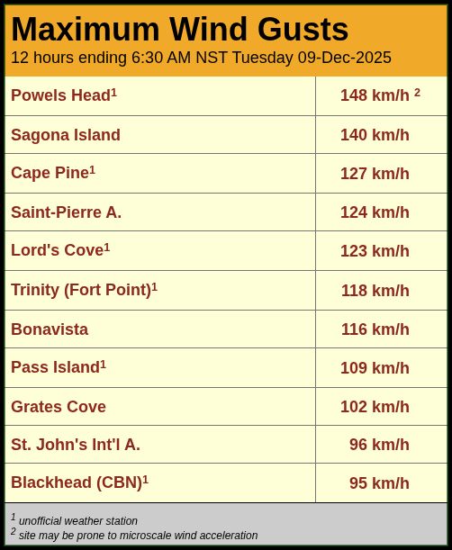
Winds quickly ramping up around the intensifying storm centre.
Peak gusts through 9 pm:
124 km/h (Saint-Pierre);
124 km/h (Sagona Island);
121 km/h (Trepassey - Powels Head);
109 km/h (Pass Island);
103 km/h (Cape Pine).
#nlwx
Peak gusts through 9 pm:
124 km/h (Saint-Pierre);
124 km/h (Sagona Island);
121 km/h (Trepassey - Powels Head);
109 km/h (Pass Island);
103 km/h (Cape Pine).
#nlwx

December 9, 2025 at 12:34 AM
Winds quickly ramping up around the intensifying storm centre.
Peak gusts through 9 pm:
124 km/h (Saint-Pierre);
124 km/h (Sagona Island);
121 km/h (Trepassey - Powels Head);
109 km/h (Pass Island);
103 km/h (Cape Pine).
#nlwx
Peak gusts through 9 pm:
124 km/h (Saint-Pierre);
124 km/h (Sagona Island);
121 km/h (Trepassey - Powels Head);
109 km/h (Pass Island);
103 km/h (Cape Pine).
#nlwx
Might be good time to do at least a rudimentary cleanup on the NE Avalon with backedge of first impulse going through.
Slice of milder air just south with 2°C at Middle Pond, 5°C at Trepassey, 3°C at Point May.
Also already gusting 104 km/h at Powels Head (Trepassey). #nlwx
Slice of milder air just south with 2°C at Middle Pond, 5°C at Trepassey, 3°C at Point May.
Also already gusting 104 km/h at Powels Head (Trepassey). #nlwx
December 8, 2025 at 11:30 PM
Might be good time to do at least a rudimentary cleanup on the NE Avalon with backedge of first impulse going through.
Slice of milder air just south with 2°C at Middle Pond, 5°C at Trepassey, 3°C at Point May.
Also already gusting 104 km/h at Powels Head (Trepassey). #nlwx
Slice of milder air just south with 2°C at Middle Pond, 5°C at Trepassey, 3°C at Point May.
Also already gusting 104 km/h at Powels Head (Trepassey). #nlwx
To those who mark the occasion: happy week-with-earliest-sunsets.
The evening-light comeback begins next week. 🌇
www.timeanddate.com #nlwx
The evening-light comeback begins next week. 🌇
www.timeanddate.com #nlwx

December 8, 2025 at 7:43 PM
To those who mark the occasion: happy week-with-earliest-sunsets.
The evening-light comeback begins next week. 🌇
www.timeanddate.com #nlwx
The evening-light comeback begins next week. 🌇
www.timeanddate.com #nlwx
Marion Bridge radar showing circulation centre driving the heaviest snow just off Cape Breton. The 996 mb centre is commencing bombogenesis, forecast to deepen by 40 mb to 956 mb in 24 hours as its track takes it across Placentia Bay tonight before moving away over the Atlantic. #nlwx
December 8, 2025 at 6:26 PM
Marion Bridge radar showing circulation centre driving the heaviest snow just off Cape Breton. The 996 mb centre is commencing bombogenesis, forecast to deepen by 40 mb to 956 mb in 24 hours as its track takes it across Placentia Bay tonight before moving away over the Atlantic. #nlwx
View from NOAA-20 VIRRS just after noon today showing yesterday's wind maker racing away as a ~960 mb low over the mid Atlantic.
Clear view of a cold and mostly snow-covered island in its wake (though still some bare ground still holding over the SE Avalon).
#nlwx
Clear view of a cold and mostly snow-covered island in its wake (though still some bare ground still holding over the SE Avalon).
#nlwx

December 6, 2025 at 7:52 PM
View from NOAA-20 VIRRS just after noon today showing yesterday's wind maker racing away as a ~960 mb low over the mid Atlantic.
Clear view of a cold and mostly snow-covered island in its wake (though still some bare ground still holding over the SE Avalon).
#nlwx
Clear view of a cold and mostly snow-covered island in its wake (though still some bare ground still holding over the SE Avalon).
#nlwx

Clear day after the snow much of #Labrador; totals from Thu night thru Fri night:
39.8 cm (Goose Bay #YYR);
25.0 cm (Makkovik);
10.0 cm (L'Anse au Loup).
Meanwhile, very cold in western Labrador this morning: Low -34.9°C at Wabush #YWK marked lowest temp since March 15. #nlwx
39.8 cm (Goose Bay #YYR);
25.0 cm (Makkovik);
10.0 cm (L'Anse au Loup).
Meanwhile, very cold in western Labrador this morning: Low -34.9°C at Wabush #YWK marked lowest temp since March 15. #nlwx


December 6, 2025 at 3:34 PM
=TIED ALL TIME RECORD=
Peak gust 165 km/h at Sagona Island this evening matches the same value from April 3, 2017, for the strongest on record at the site.
Data available back to 1995 (with some gaps). #nlwx
Peak gust 165 km/h at Sagona Island this evening matches the same value from April 3, 2017, for the strongest on record at the site.
Data available back to 1995 (with some gaps). #nlwx
December 6, 2025 at 3:11 AM
=TIED ALL TIME RECORD=
Peak gust 165 km/h at Sagona Island this evening matches the same value from April 3, 2017, for the strongest on record at the site.
Data available back to 1995 (with some gaps). #nlwx
Peak gust 165 km/h at Sagona Island this evening matches the same value from April 3, 2017, for the strongest on record at the site.
Data available back to 1995 (with some gaps). #nlwx
Tad breezy out there. Some peaks (km/h) thru 5pm:
146 (Sagona I.);
140 (Cape Bonavista);
140 (Cape St. Mary's);
132 (Pass I.);
129 (Cape Pine);
125 (Port aux Basques);
124 (Wreckhouse);
121 (Trepassey);
115 (St-Pierre);
111 (Bonavista);
102 (Burgeo);
102 (Winterland).
#nlwx
146 (Sagona I.);
140 (Cape Bonavista);
140 (Cape St. Mary's);
132 (Pass I.);
129 (Cape Pine);
125 (Port aux Basques);
124 (Wreckhouse);
121 (Trepassey);
115 (St-Pierre);
111 (Bonavista);
102 (Burgeo);
102 (Winterland).
#nlwx
December 5, 2025 at 8:32 PM
Tad breezy out there. Some peaks (km/h) thru 5pm:
146 (Sagona I.);
140 (Cape Bonavista);
140 (Cape St. Mary's);
132 (Pass I.);
129 (Cape Pine);
125 (Port aux Basques);
124 (Wreckhouse);
121 (Trepassey);
115 (St-Pierre);
111 (Bonavista);
102 (Burgeo);
102 (Winterland).
#nlwx
146 (Sagona I.);
140 (Cape Bonavista);
140 (Cape St. Mary's);
132 (Pass I.);
129 (Cape Pine);
125 (Port aux Basques);
124 (Wreckhouse);
121 (Trepassey);
115 (St-Pierre);
111 (Bonavista);
102 (Burgeo);
102 (Winterland).
#nlwx
Another day, another round of snow gets underway. Measuring 4.8 cm through 8:30 am in #GanderWest (since starting during the night). Winds have shifted and are increasing. #nlwx

December 5, 2025 at 12:32 PM
Another day, another round of snow gets underway. Measuring 4.8 cm through 8:30 am in #GanderWest (since starting during the night). Winds have shifted and are increasing. #nlwx
Full list of numbers from yesterday's first solid taste of winter for many of us. weather.gc.ca/warnings/wea... #nlwx

December 4, 2025 at 8:33 PM
Full list of numbers from yesterday's first solid taste of winter for many of us. weather.gc.ca/warnings/wea... #nlwx
Final total 32.8 cm in #GanderWest (all but the first 0.5 cm attributed to the @CoCoRaHSCanada Dec 3 entry). Water equiv 27.9 mm.
Minor compaction brings the depth down to 30 cm this morning, but that’s still more than was recorded on the ground at any time last winter! #nlwx
Minor compaction brings the depth down to 30 cm this morning, but that’s still more than was recorded on the ground at any time last winter! #nlwx


December 4, 2025 at 12:02 PM
Final total 32.8 cm in #GanderWest (all but the first 0.5 cm attributed to the @CoCoRaHSCanada Dec 3 entry). Water equiv 27.9 mm.
Minor compaction brings the depth down to 30 cm this morning, but that’s still more than was recorded on the ground at any time last winter! #nlwx
Minor compaction brings the depth down to 30 cm this morning, but that’s still more than was recorded on the ground at any time last winter! #nlwx
Snowfall 31.8 cm through 11pm in #GanderWest; water equivalent 26.7 mm, making for an approximate snow-to-liquid ratio of 12:1. The drier nature definitely helps with the cleanup!
Still some light snow falling, so will have to wait until morning for the final total. #nlwx
Still some light snow falling, so will have to wait until morning for the final total. #nlwx

December 4, 2025 at 2:34 AM
Snowfall 31.8 cm through 11pm in #GanderWest; water equivalent 26.7 mm, making for an approximate snow-to-liquid ratio of 12:1. The drier nature definitely helps with the cleanup!
Still some light snow falling, so will have to wait until morning for the final total. #nlwx
Still some light snow falling, so will have to wait until morning for the final total. #nlwx

Some snowfall amounts from the middle part of the island as of 5:30 pm:
30 cm (Terra Nova);
25 cm (#GanderWest);
25 cm (Millertown);
24 cm (St. Alban's).
Rates have eased from earlier but still accumulating 1-2 cm per hour in Central. Expected to wrap up near midnight. #nlwx
30 cm (Terra Nova);
25 cm (#GanderWest);
25 cm (Millertown);
24 cm (St. Alban's).
Rates have eased from earlier but still accumulating 1-2 cm per hour in Central. Expected to wrap up near midnight. #nlwx
December 3, 2025 at 9:10 PM
Some snowfall amounts from the middle part of the island as of 5:30 pm:
30 cm (Terra Nova);
25 cm (#GanderWest);
25 cm (Millertown);
24 cm (St. Alban's).
Rates have eased from earlier but still accumulating 1-2 cm per hour in Central. Expected to wrap up near midnight. #nlwx
30 cm (Terra Nova);
25 cm (#GanderWest);
25 cm (Millertown);
24 cm (St. Alban's).
Rates have eased from earlier but still accumulating 1-2 cm per hour in Central. Expected to wrap up near midnight. #nlwx
Rainfall amounts (thru 4:30 pm) from the mild part of the storm:
45.0 mm (Lord's Cove);
45.0 mm (St. Lawrence);
40.4 mm (Lamaline);
36.3 mm (Cape Pine);
35.8 mm (Cape Race);
30.5 mm (St. Joseph's).
#nlwx
45.0 mm (Lord's Cove);
45.0 mm (St. Lawrence);
40.4 mm (Lamaline);
36.3 mm (Cape Pine);
35.8 mm (Cape Race);
30.5 mm (St. Joseph's).
#nlwx
December 3, 2025 at 8:07 PM
Rainfall amounts (thru 4:30 pm) from the mild part of the storm:
45.0 mm (Lord's Cove);
45.0 mm (St. Lawrence);
40.4 mm (Lamaline);
36.3 mm (Cape Pine);
35.8 mm (Cape Race);
30.5 mm (St. Joseph's).
#nlwx
45.0 mm (Lord's Cove);
45.0 mm (St. Lawrence);
40.4 mm (Lamaline);
36.3 mm (Cape Pine);
35.8 mm (Cape Race);
30.5 mm (St. Joseph's).
#nlwx
Total snowfall 17 cm at St. John's #YYT prior to mid-afternoon change to rain.
3:30 pm temperatures: 0.6°C at the airport; 2.2°C downtown.
Local webcams around Metro show accumulations vary with elevation. apps.stjohns.ca/accessstjohn... #nlwx
3:30 pm temperatures: 0.6°C at the airport; 2.2°C downtown.
Local webcams around Metro show accumulations vary with elevation. apps.stjohns.ca/accessstjohn... #nlwx


December 3, 2025 at 7:04 PM
Total snowfall 17 cm at St. John's #YYT prior to mid-afternoon change to rain.
3:30 pm temperatures: 0.6°C at the airport; 2.2°C downtown.
Local webcams around Metro show accumulations vary with elevation. apps.stjohns.ca/accessstjohn... #nlwx
3:30 pm temperatures: 0.6°C at the airport; 2.2°C downtown.
Local webcams around Metro show accumulations vary with elevation. apps.stjohns.ca/accessstjohn... #nlwx
Into intense snowfall in Central; measuring 14 cm as of 2pm in #GanderWest. Plenty more to come, rates currently 5-6 cm per hour. #nlwx


December 3, 2025 at 5:47 PM
Into intense snowfall in Central; measuring 14 cm as of 2pm in #GanderWest. Plenty more to come, rates currently 5-6 cm per hour. #nlwx


Snow began overnight in #GanderWest so first measurement of the event (0.5 cm) gets attributed to the Dec 2 reporting day for CoCoRaHS (24-hr period ending 7am Dec 3). #nlwx

December 3, 2025 at 10:49 AM
Snow began overnight in #GanderWest so first measurement of the event (0.5 cm) gets attributed to the Dec 2 reporting day for CoCoRaHS (24-hr period ending 7am Dec 3). #nlwx