


Oliver Wipfli
@oliverwipfli.ch
Got some settings wrong

March 26, 2025 at 4:55 PM
Got some settings wrong
Tilezen railways at zoom 5.
Can inspect the map here by selecting only the transit layer: pmtiles.io?url=https%3A...
Can inspect the map here by selecting only the transit layer: pmtiles.io?url=https%3A...

March 12, 2025 at 6:27 AM
Tilezen railways at zoom 5.
Can inspect the map here by selecting only the transit layer: pmtiles.io?url=https%3A...
Can inspect the map here by selecting only the transit layer: pmtiles.io?url=https%3A...
And same for upload... It fluctuates between 80 MB/s and 115 MB/s.

February 28, 2025 at 11:02 AM
And same for upload... It fluctuates between 80 MB/s and 115 MB/s.
I have just upgraded to gigabit internet at home. Can really recommend iWay.ch! Downloading a large file from my hetzner which has also a 1 Gbps line gives this:

February 28, 2025 at 10:55 AM
I have just upgraded to gigabit internet at home. Can really recommend iWay.ch! Downloading a large file from my hetzner which has also a 1 Gbps line gives this:

Google Maps Bretagne

January 24, 2025 at 7:47 AM
Google Maps Bretagne
Bretagne is a nice example for bad road network rendering if you select minzooms purely based on semantics like the OpenStreetMap highway tag. Roads alternate here between highway=trunk and highway=primary. If you select now only the highway=trunk roads, you get a lot of gaps...

January 24, 2025 at 7:43 AM
Bretagne is a nice example for bad road network rendering if you select minzooms purely based on semantics like the OpenStreetMap highway tag. Roads alternate here between highway=trunk and highway=primary. If you select now only the highway=trunk roads, you get a lot of gaps...

Small blog post about how country, state, and city labels are placed at low zoom levels on Google Maps:
oliverwipfli.ch/positioning-...
oliverwipfli.ch/positioning-...

January 8, 2025 at 4:25 PM
Small blog post about how country, state, and city labels are placed at low zoom levels on Google Maps:
oliverwipfli.ch/positioning-...
oliverwipfli.ch/positioning-...
Collapsing carriageways. Points are attracted by 1/distance and cos(angle difference of attached line segments). Feels a bit like Physics...
wipfli.github.io/magnetron/bo...
wipfli.github.io/magnetron/bo...

January 5, 2025 at 1:51 PM
Collapsing carriageways. Points are attracted by 1/distance and cos(angle difference of attached line segments). Feels a bit like Physics...
wipfli.github.io/magnetron/bo...
wipfli.github.io/magnetron/bo...

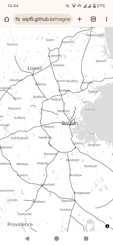
Something is wrong with the vector tile of the Boston area...

January 4, 2025 at 7:37 PM
Something is wrong with the vector tile of the Boston area...
MapLibre GL JS v5.0.0 has been released and it comes with a nice new globe feature. Congrats everyone who worked on this!
maplibre.org/maplibre-gl-...
maplibre.org/maplibre-gl-...

January 4, 2025 at 6:15 PM
MapLibre GL JS v5.0.0 has been released and it comes with a nice new globe feature. Congrats everyone who worked on this!
maplibre.org/maplibre-gl-...
maplibre.org/maplibre-gl-...
I just remembered that some time ago I vectorized the hand-drawn hillshading of swisstopo and put it on a MapLibre-based map. Demo: wipfli.github.io/swiss-map/ve...

January 2, 2025 at 5:37 PM
I just remembered that some time ago I vectorized the hand-drawn hillshading of swisstopo and put it on a MapLibre-based map. Demo: wipfli.github.io/swiss-map/ve...
I'm experimenting with highway generalization for low zoom levels. In this screenshot I made the lines collapse by looking for close by points up to a certain radius, then taking the midpoint of those. Doing this multiple times converges the points and sort of smooths lines...

December 27, 2024 at 4:14 PM
I'm experimenting with highway generalization for low zoom levels. In this screenshot I made the lines collapse by looking for close by points up to a certain radius, then taking the midpoint of those. Doing this multiple times converges the points and sort of smooths lines...
I am looking a bit into vertical text layout of Japanese in MapLibre GL JS. Interesting how some characters are displayed with 90 degree rotation in vertical text. For example the string "(東京タワー…)" becomes this

December 26, 2024 at 3:06 PM
I am looking a bit into vertical text layout of Japanese in MapLibre GL JS. Interesting how some characters are displayed with 90 degree rotation in vertical text. For example the string "(東京タワー…)" becomes this
Selecting which roads to display on a map at a given scale is an interesting problem. One approach is the stroke-mesh method which prunes roads based on local density and length of dead-ends. Have a look at Benz and Weibel 2014 www.zora.uzh.ch/id/eprint/10...

December 22, 2024 at 7:23 AM
Selecting which roads to display on a map at a given scale is an interesting problem. One approach is the stroke-mesh method which prunes roads based on local density and length of dead-ends. Have a look at Benz and Weibel 2014 www.zora.uzh.ch/id/eprint/10...

Monaco is always nice to look at...
Data: OpenStreetMap contributor. Made with Planetiler using if (sourceFeature.canBeLine()) and visualized with tileserver-gl/MapLibre GL JS.
Data: OpenStreetMap contributor. Made with Planetiler using if (sourceFeature.canBeLine()) and visualized with tileserver-gl/MapLibre GL JS.

December 20, 2024 at 7:37 PM
Monaco is always nice to look at...
Data: OpenStreetMap contributor. Made with Planetiler using if (sourceFeature.canBeLine()) and visualized with tileserver-gl/MapLibre GL JS.
Data: OpenStreetMap contributor. Made with Planetiler using if (sourceFeature.canBeLine()) and visualized with tileserver-gl/MapLibre GL JS.
At Thursday's GeoBeer #46 in Rapperswil I will share a poster with the title "Vector Tiles Overview". Looking forward to meet you there if you are around...

December 16, 2024 at 9:52 AM
At Thursday's GeoBeer #46 in Rapperswil I will share a poster with the title "Vector Tiles Overview". Looking forward to meet you there if you are around...
Fabian Rechsteiner compared the performance of PostGIS-backed tile servers such as Martin, Tegola, BBOX and a few more. It looks like Martin is the fastest out there...
unigis.at/files/Master...
unigis.at/files/Master...

December 13, 2024 at 1:42 PM
Fabian Rechsteiner compared the performance of PostGIS-backed tile servers such as Martin, Tegola, BBOX and a few more. It looks like Martin is the fastest out there...
unigis.at/files/Master...
unigis.at/files/Master...
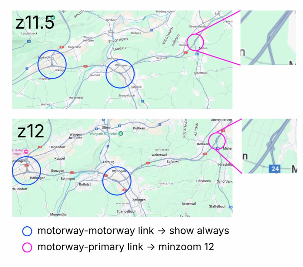
Google Maps seems to show links between motorways at all zoom levels, but links from motorway to primary roads seem to be visible only from zoom 12.
Has anyone done something like this with OpenStreetMap data?
Has anyone done something like this with OpenStreetMap data?
December 9, 2024 at 8:57 AM
Google Maps seems to show links between motorways at all zoom levels, but links from motorway to primary roads seem to be visible only from zoom 12.
Has anyone done something like this with OpenStreetMap data?
Has anyone done something like this with OpenStreetMap data?
Identifying road importance by routing between 10k buildings in Zürich. Uses OpenStreetMap data and OSRM for routing...

December 2, 2024 at 4:41 PM
Identifying road importance by routing between 10k buildings in Zürich. Uses OpenStreetMap data and OSRM for routing...

Added a globe control for the MapLibre v5 fans...

November 22, 2024 at 2:53 PM
Added a globe control for the MapLibre v5 fans...