


Oliver Wipfli
@oliverwipfli.ch
MapLibre GL JS can still use server-generated pbf fonts, but it does not have to use them any more thanks to github.com/maplibre/map...

Render glyphs locally if glyph PBF is unspecified or unavailable by 1ec5 · Pull Request #4564 · maplibre/maplibre-gl-js
This implements the GL JS side of “Extended SDF” as proposed in maplibre/maplibre-style-spec#1045 and specified in maplibre/maplibre-style-spec#1068. GL JS no longer refuses to load a stylesheet if...
github.com
November 5, 2025 at 11:16 AM
MapLibre GL JS can still use server-generated pbf fonts, but it does not have to use them any more thanks to github.com/maplibre/map...
Reposted by Oliver Wipfli
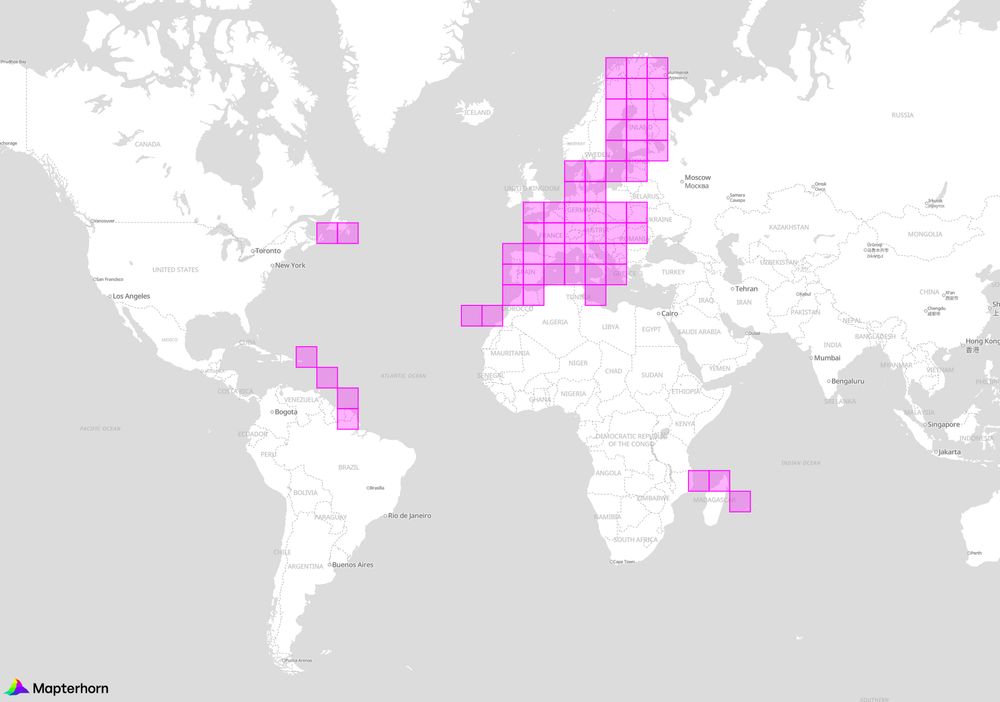
Mapterhorn v0.0.4 ships high-resolution terrain data for Belgium, Czech Republic, Denmark, Estonia, Finland, France, Germany, Italy, Latvia, Luxembourg, Romania, Slovakia, Slovenia, and Spain.
Explore the map at mapterhorn.com/viewer/#map=...
Explore the map at mapterhorn.com/viewer/#map=...
October 20, 2025 at 8:27 AM
Mapterhorn v0.0.4 ships high-resolution terrain data for Belgium, Czech Republic, Denmark, Estonia, Finland, France, Germany, Italy, Latvia, Luxembourg, Romania, Slovakia, Slovenia, and Spain.
Explore the map at mapterhorn.com/viewer/#map=...
Explore the map at mapterhorn.com/viewer/#map=...
Reposted by Oliver Wipfli
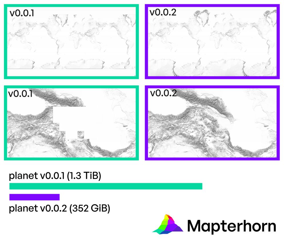
Mapterhorn v0.0.2 ships smaller tiles that are optimized for size while keeping the same visual quality, missing data in Caucasus and polar regions were added, and you can now use the pmtiles cli tool to make small area extracts.
mapterhorn.com
mapterhorn.com
August 20, 2025 at 11:24 AM
Mapterhorn v0.0.2 ships smaller tiles that are optimized for size while keeping the same visual quality, missing data in Caucasus and polar regions were added, and you can now use the pmtiles cli tool to make small area extracts.
mapterhorn.com
mapterhorn.com
Reposted by Oliver Wipfli

This is amazing, a beautiful, global terrain layer in PMTiles format! Thank you for making this Oliver @oliverwipfli.ch!
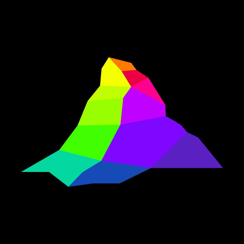
Mapterhorn v0.0.1 has been released. It is an aggregation of the global Copernicus GLO-30 low-resolution digital elevation model with the Swiss swissALTI3D high-resolution model. mapterhorn.com
mapterhorn
Open terrain tile sets and data catalog
mapterhorn.com
August 11, 2025 at 9:31 AM
This is amazing, a beautiful, global terrain layer in PMTiles format! Thank you for making this Oliver @oliverwipfli.ch!
Reposted by Oliver Wipfli

Have you been waiting for "Protomaps Terrain"?
It's arriving! @mapterhorn.com is an independent project created by @oliverwipfli.ch - a global elevation model built from multiple sources, distributed as a single PMTiles archive
It's arriving! @mapterhorn.com is an independent project created by @oliverwipfli.ch - a global elevation model built from multiple sources, distributed as a single PMTiles archive
Mapterhorn v0.0.1 has been released. It is an aggregation of the global Copernicus GLO-30 low-resolution digital elevation model with the Swiss swissALTI3D high-resolution model. mapterhorn.com
mapterhorn
Open terrain tile sets and data catalog
mapterhorn.com
August 11, 2025 at 9:07 AM
Have you been waiting for "Protomaps Terrain"?
It's arriving! @mapterhorn.com is an independent project created by @oliverwipfli.ch - a global elevation model built from multiple sources, distributed as a single PMTiles archive
It's arriving! @mapterhorn.com is an independent project created by @oliverwipfli.ch - a global elevation model built from multiple sources, distributed as a single PMTiles archive
Reposted by Oliver Wipfli
Mapterhorn v0.0.1 has been released. It is an aggregation of the global Copernicus GLO-30 low-resolution digital elevation model with the Swiss swissALTI3D high-resolution model. mapterhorn.com
mapterhorn
Open terrain tile sets and data catalog
mapterhorn.com
August 8, 2025 at 3:32 PM
Mapterhorn v0.0.1 has been released. It is an aggregation of the global Copernicus GLO-30 low-resolution digital elevation model with the Swiss swissALTI3D high-resolution model. mapterhorn.com
Got some settings wrong

March 26, 2025 at 4:55 PM
Got some settings wrong
Reposted by Oliver Wipfli
try out a new Rasterio plugin for converting GeoTIFF to PMTiles:
pip install rio-pmtiles
github.com/protomaps/PM...
pip install rio-pmtiles
github.com/protomaps/PM...
March 24, 2025 at 3:15 AM
try out a new Rasterio plugin for converting GeoTIFF to PMTiles:
pip install rio-pmtiles
github.com/protomaps/PM...
pip install rio-pmtiles
github.com/protomaps/PM...
Tilezen railways at zoom 5.
Can inspect the map here by selecting only the transit layer: pmtiles.io?url=https%3A...
Can inspect the map here by selecting only the transit layer: pmtiles.io?url=https%3A...

March 12, 2025 at 6:27 AM
Tilezen railways at zoom 5.
Can inspect the map here by selecting only the transit layer: pmtiles.io?url=https%3A...
Can inspect the map here by selecting only the transit layer: pmtiles.io?url=https%3A...
I have just upgraded to gigabit internet at home. Can really recommend iWay.ch! Downloading a large file from my hetzner which has also a 1 Gbps line gives this:

February 28, 2025 at 10:55 AM
I have just upgraded to gigabit internet at home. Can really recommend iWay.ch! Downloading a large file from my hetzner which has also a 1 Gbps line gives this:
Reposted by Oliver Wipfli

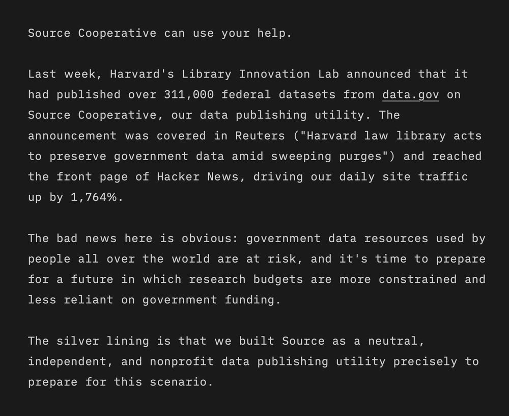
We're seeking funding to take @source.coop to the next level.


February 12, 2025 at 5:52 PM
We're seeking funding to take @source.coop to the next level.
Reposted by Oliver Wipfli

I have been appointed as the CEO of MIERUNE.
I will do my best to contribute to society and clients more than ever by geospatial technology.
www.mierune.co.jp?lang=en
I will do my best to contribute to society and clients more than ever by geospatial technology.
www.mierune.co.jp?lang=en

位置情報に関する課題解決 | MIERUNE
MIERUNEはQGIS・MapTiler・WebGISに関する豊富な技術や経験をもとに、位置情報に関する課題解決をサポートするソリューションカンパニーです。これまで蓄積された技術力や実績をベースに、クライアント企業様がお持ちの位置データのコンサルティング・システム開発などで課題解決や業務効率化を強力にサポートします。
www.mierune.co.jp
February 3, 2025 at 1:03 PM
I have been appointed as the CEO of MIERUNE.
I will do my best to contribute to society and clients more than ever by geospatial technology.
www.mierune.co.jp?lang=en
I will do my best to contribute to society and clients more than ever by geospatial technology.
www.mierune.co.jp?lang=en
ChatGPT guesses correctly in 78 out of 93 test cases if a Burmese string uses Zawgyi or Unicode encoding. Not too bad...
Test cases were taken from CLDR github.com/unicode-org/...
Test cases were taken from CLDR github.com/unicode-org/...
February 3, 2025 at 10:57 AM
ChatGPT guesses correctly in 78 out of 93 test cases if a Burmese string uses Zawgyi or Unicode encoding. Not too bad...
Test cases were taken from CLDR github.com/unicode-org/...
Test cases were taken from CLDR github.com/unicode-org/...
Bretagne is a nice example for bad road network rendering if you select minzooms purely based on semantics like the OpenStreetMap highway tag. Roads alternate here between highway=trunk and highway=primary. If you select now only the highway=trunk roads, you get a lot of gaps...

January 24, 2025 at 7:43 AM
Bretagne is a nice example for bad road network rendering if you select minzooms purely based on semantics like the OpenStreetMap highway tag. Roads alternate here between highway=trunk and highway=primary. If you select now only the highway=trunk roads, you get a lot of gaps...

Small blog post about how country, state, and city labels are placed at low zoom levels on Google Maps:
oliverwipfli.ch/positioning-...
oliverwipfli.ch/positioning-...

January 8, 2025 at 4:25 PM
Small blog post about how country, state, and city labels are placed at low zoom levels on Google Maps:
oliverwipfli.ch/positioning-...
oliverwipfli.ch/positioning-...
Collapsing carriageways. Points are attracted by 1/distance and cos(angle difference of attached line segments). Feels a bit like Physics...
wipfli.github.io/magnetron/bo...
wipfli.github.io/magnetron/bo...

January 5, 2025 at 1:51 PM
Collapsing carriageways. Points are attracted by 1/distance and cos(angle difference of attached line segments). Feels a bit like Physics...
wipfli.github.io/magnetron/bo...
wipfli.github.io/magnetron/bo...
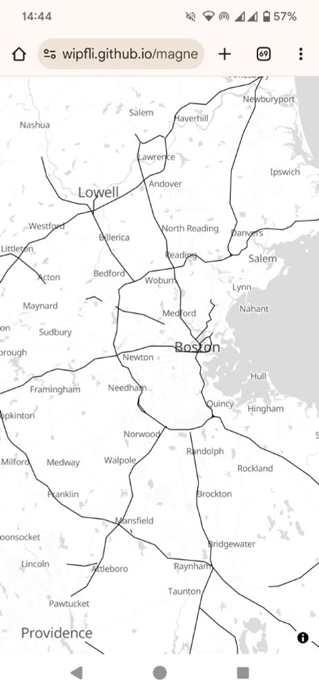
Something is wrong with the vector tile of the Boston area...

January 4, 2025 at 7:37 PM
Something is wrong with the vector tile of the Boston area...
MapLibre GL JS v5.0.0 has been released and it comes with a nice new globe feature. Congrats everyone who worked on this!
maplibre.org/maplibre-gl-...
maplibre.org/maplibre-gl-...

January 4, 2025 at 6:15 PM
MapLibre GL JS v5.0.0 has been released and it comes with a nice new globe feature. Congrats everyone who worked on this!
maplibre.org/maplibre-gl-...
maplibre.org/maplibre-gl-...
I just remembered that some time ago I vectorized the hand-drawn hillshading of swisstopo and put it on a MapLibre-based map. Demo: wipfli.github.io/swiss-map/ve...

January 2, 2025 at 5:37 PM
I just remembered that some time ago I vectorized the hand-drawn hillshading of swisstopo and put it on a MapLibre-based map. Demo: wipfli.github.io/swiss-map/ve...
I'm experimenting with highway generalization for low zoom levels. In this screenshot I made the lines collapse by looking for close by points up to a certain radius, then taking the midpoint of those. Doing this multiple times converges the points and sort of smooths lines...

December 27, 2024 at 4:14 PM
I'm experimenting with highway generalization for low zoom levels. In this screenshot I made the lines collapse by looking for close by points up to a certain radius, then taking the midpoint of those. Doing this multiple times converges the points and sort of smooths lines...
I am looking a bit into vertical text layout of Japanese in MapLibre GL JS. Interesting how some characters are displayed with 90 degree rotation in vertical text. For example the string "(東京タワー…)" becomes this

December 26, 2024 at 3:06 PM
I am looking a bit into vertical text layout of Japanese in MapLibre GL JS. Interesting how some characters are displayed with 90 degree rotation in vertical text. For example the string "(東京タワー…)" becomes this
Selecting which roads to display on a map at a given scale is an interesting problem. One approach is the stroke-mesh method which prunes roads based on local density and length of dead-ends. Have a look at Benz and Weibel 2014 www.zora.uzh.ch/id/eprint/10...

December 22, 2024 at 7:23 AM
Selecting which roads to display on a map at a given scale is an interesting problem. One approach is the stroke-mesh method which prunes roads based on local density and length of dead-ends. Have a look at Benz and Weibel 2014 www.zora.uzh.ch/id/eprint/10...
Monaco is always nice to look at...
Data: OpenStreetMap contributor. Made with Planetiler using if (sourceFeature.canBeLine()) and visualized with tileserver-gl/MapLibre GL JS.
Data: OpenStreetMap contributor. Made with Planetiler using if (sourceFeature.canBeLine()) and visualized with tileserver-gl/MapLibre GL JS.

December 20, 2024 at 7:37 PM
Monaco is always nice to look at...
Data: OpenStreetMap contributor. Made with Planetiler using if (sourceFeature.canBeLine()) and visualized with tileserver-gl/MapLibre GL JS.
Data: OpenStreetMap contributor. Made with Planetiler using if (sourceFeature.canBeLine()) and visualized with tileserver-gl/MapLibre GL JS.