


MyRadar
@myradar.bsky.social
Keeping you ahead of the storm since 2008. Download for FREE! myradar.com
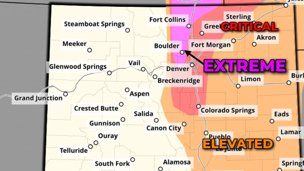
Boulder and the northwest suburbs of Denver are included in the Storm Prediction Center's zone for "extreme" fire danger – the agency's highest tier.
December 19, 2025 at 6:17 PM
Boulder and the northwest suburbs of Denver are included in the Storm Prediction Center's zone for "extreme" fire danger – the agency's highest tier.
Here's a map of where controlled power shutoffs have occurred in Colorado, via XCel Energy.
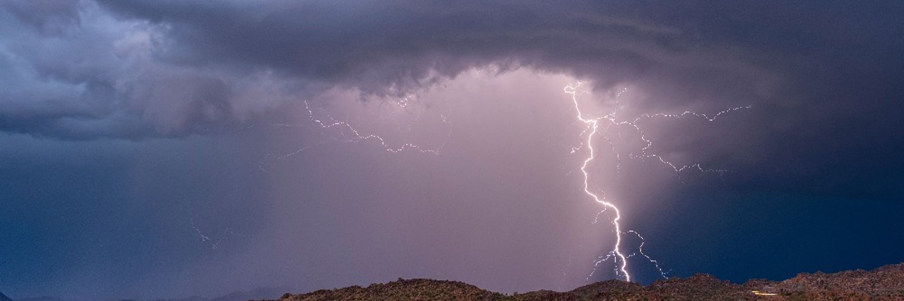
Extreme fire danger amid strong/destructive foothill winds and bone-dry air.
Extreme fire danger amid strong/destructive foothill winds and bone-dry air.

December 19, 2025 at 6:16 PM
Here's a map of where controlled power shutoffs have occurred in Colorado, via XCel Energy.
Extreme fire danger amid strong/destructive foothill winds and bone-dry air.
Extreme fire danger amid strong/destructive foothill winds and bone-dry air.
If we take a slice through the atmosphere, we can see strong winds sliding over the lip of the Rockies.
Air cascades downhill like water spilling over a damn.
That air descends, dries out and accelerates, bringing a parched, damaging wind.
Air cascades downhill like water spilling over a damn.
That air descends, dries out and accelerates, bringing a parched, damaging wind.

December 19, 2025 at 6:15 PM
If we take a slice through the atmosphere, we can see strong winds sliding over the lip of the Rockies.
Air cascades downhill like water spilling over a damn.
That air descends, dries out and accelerates, bringing a parched, damaging wind.
Air cascades downhill like water spilling over a damn.
That air descends, dries out and accelerates, bringing a parched, damaging wind.
TORNADO WARNING in Hawaii!?
A tornado warning was issued at 6:37 a.m. local time Friday morning for Hawaii’s westernmost island. This was for Niihau in Kauai County.
.
A tornado warning was issued at 6:37 a.m. local time Friday morning for Hawaii’s westernmost island. This was for Niihau in Kauai County.
.

December 19, 2025 at 5:07 PM
TORNADO WARNING in Hawaii!?
A tornado warning was issued at 6:37 a.m. local time Friday morning for Hawaii’s westernmost island. This was for Niihau in Kauai County.
.
A tornado warning was issued at 6:37 a.m. local time Friday morning for Hawaii’s westernmost island. This was for Niihau in Kauai County.
.
EXTREME fire danger in the Front Range/Rockies behind a wind shift coming in. In the Denver/Boulder area, the first-ever Colorado PDS – Particularly Dangerous Situation – fire weather warning is in effect.

December 19, 2025 at 2:42 PM
EXTREME fire danger in the Front Range/Rockies behind a wind shift coming in. In the Denver/Boulder area, the first-ever Colorado PDS – Particularly Dangerous Situation – fire weather warning is in effect.
Look at these wind gusts in the Front Range... up to 80 mph in the Foothills.
Bone dry relative humidities down to 8-10% will make for extreme fire danger.
If anything crops up in the mountains west of Boulder, it will be fanned east quickly. Please take this seriously.
Bone dry relative humidities down to 8-10% will make for extreme fire danger.
If anything crops up in the mountains west of Boulder, it will be fanned east quickly. Please take this seriously.

December 19, 2025 at 2:35 PM
Look at these wind gusts in the Front Range... up to 80 mph in the Foothills.
Bone dry relative humidities down to 8-10% will make for extreme fire danger.
If anything crops up in the mountains west of Boulder, it will be fanned east quickly. Please take this seriously.
Bone dry relative humidities down to 8-10% will make for extreme fire danger.
If anything crops up in the mountains west of Boulder, it will be fanned east quickly. Please take this seriously.
Colorado's first PARTICULARLY DANGEROUS SITUATION fire weather warning is in effect for the west side of Denver and Boulder.
Foothill gusts to 80 mph and relative humidities of 10-15 percent will favor extreme fire behavior and rapid spread should ignition occur.
Take this seriously!
Foothill gusts to 80 mph and relative humidities of 10-15 percent will favor extreme fire behavior and rapid spread should ignition occur.
Take this seriously!

December 19, 2025 at 1:25 PM
Colorado's first PARTICULARLY DANGEROUS SITUATION fire weather warning is in effect for the west side of Denver and Boulder.
Foothill gusts to 80 mph and relative humidities of 10-15 percent will favor extreme fire behavior and rapid spread should ignition occur.
Take this seriously!
Foothill gusts to 80 mph and relative humidities of 10-15 percent will favor extreme fire behavior and rapid spread should ignition occur.
Take this seriously!
FRIDAY, December 19 – EXTREMELY DANGEROUS fire weather situation in the Denver and Boulder metro areas. PLEASE TAKE THIS SERIOUSLY!
For the first time on record, a PDS – Particularly Dangerous Situation – fire weather warning has been issued.
For the first time on record, a PDS – Particularly Dangerous Situation – fire weather warning has been issued.

December 19, 2025 at 2:11 AM
FRIDAY, December 19 – EXTREMELY DANGEROUS fire weather situation in the Denver and Boulder metro areas. PLEASE TAKE THIS SERIOUSLY!
For the first time on record, a PDS – Particularly Dangerous Situation – fire weather warning has been issued.
For the first time on record, a PDS – Particularly Dangerous Situation – fire weather warning has been issued.
December 19, 2025 at 2:06 AM
FRIDAY, December 19 – EXTREMELY DANGEROUS fire weather situation in the Denver and Boulder metro areas. PLEASE TAKE THIS SERIOUSLY!
For the first time on record, a PDS – Particularly Dangerous Situation – fire weather warning has been issued.
For the first time on record, a PDS – Particularly Dangerous Situation – fire weather warning has been issued.
Wow! Sneaky but increasing tornado risk in eastern Mississippi and northwest Alabama!
Tornado watch in effect until 9 PM.
Plentiful shear (changing winds with height) but not a ton of juice. Multiple low-topped supercells with spin. Isolated tornadoes possible.
Tornado watch in effect until 9 PM.
Plentiful shear (changing winds with height) but not a ton of juice. Multiple low-topped supercells with spin. Isolated tornadoes possible.

December 18, 2025 at 11:32 PM
Wow! Sneaky but increasing tornado risk in eastern Mississippi and northwest Alabama!
Tornado watch in effect until 9 PM.
Plentiful shear (changing winds with height) but not a ton of juice. Multiple low-topped supercells with spin. Isolated tornadoes possible.
Tornado watch in effect until 9 PM.
Plentiful shear (changing winds with height) but not a ton of juice. Multiple low-topped supercells with spin. Isolated tornadoes possible.
Friday AM, 12/19, could feature a sneaky low-end tornado risk over eastern parts of the Carolinas or Delmarva.
December 18, 2025 at 6:15 PM
Friday AM, 12/19, could feature a sneaky low-end tornado risk over eastern parts of the Carolinas or Delmarva.
Shorts weather on Christmas!?

December 18, 2025 at 5:59 PM
Shorts weather on Christmas!?
Another day of fire weather concerns in Kansas and Colorado today.
Cold, dry air is being dragged southeast behind a pair of cold fronts.
As it "downslopes" down the Rockies, it dries out even more and accelerates since it's dense. FIRE WEATHER worries.
Cold, dry air is being dragged southeast behind a pair of cold fronts.
As it "downslopes" down the Rockies, it dries out even more and accelerates since it's dense. FIRE WEATHER worries.


December 18, 2025 at 5:25 PM
Another day of fire weather concerns in Kansas and Colorado today.
Cold, dry air is being dragged southeast behind a pair of cold fronts.
As it "downslopes" down the Rockies, it dries out even more and accelerates since it's dense. FIRE WEATHER worries.
Cold, dry air is being dragged southeast behind a pair of cold fronts.
As it "downslopes" down the Rockies, it dries out even more and accelerates since it's dense. FIRE WEATHER worries.
Tornado WARNING northwest of St. Louis!
“Kink in the line” circulation may produce a brief tornado near Batchtown, Ill.
“Kink in the line” circulation may produce a brief tornado near Batchtown, Ill.


December 18, 2025 at 4:47 PM
Tornado WARNING northwest of St. Louis!
“Kink in the line” circulation may produce a brief tornado near Batchtown, Ill.
“Kink in the line” circulation may produce a brief tornado near Batchtown, Ill.
The winds are fierce across the Plains today! Fortunately, they should taper some this evening.
Travel may be impossible for high-profile vehicles, like 18-wheelers.
Travel may be impossible for high-profile vehicles, like 18-wheelers.

December 18, 2025 at 4:42 PM
The winds are fierce across the Plains today! Fortunately, they should taper some this evening.
Travel may be impossible for high-profile vehicles, like 18-wheelers.
Travel may be impossible for high-profile vehicles, like 18-wheelers.
TONS of jet stream energy working overhead tonight into Friday... if any tall downpours develop, some of that momentum will be mixed to the surface in the form of locally damaging gusts.
December 18, 2025 at 4:36 PM
TONS of jet stream energy working overhead tonight into Friday... if any tall downpours develop, some of that momentum will be mixed to the surface in the form of locally damaging gusts.
Plains gang – DESTRUCTIVE GUSTS are sweeping out of South Dakota into Nebraska and may reach northern Kansas and western Iowa!
A gust to 90 mph was recently reported at Rapid City Airport in western South Dakota – with gusts over 100 mph in the mountains.
SERIOUS windstorm!
A gust to 90 mph was recently reported at Rapid City Airport in western South Dakota – with gusts over 100 mph in the mountains.
SERIOUS windstorm!

December 18, 2025 at 12:54 PM
Plains gang – DESTRUCTIVE GUSTS are sweeping out of South Dakota into Nebraska and may reach northern Kansas and western Iowa!
A gust to 90 mph was recently reported at Rapid City Airport in western South Dakota – with gusts over 100 mph in the mountains.
SERIOUS windstorm!
A gust to 90 mph was recently reported at Rapid City Airport in western South Dakota – with gusts over 100 mph in the mountains.
SERIOUS windstorm!
LOTS of power outages in the Pacific Northwest after last night's atmospheric river/wind gusts.
And another atmospheric river – an even stronger one – is coming Thursday.
And another atmospheric river – an even stronger one – is coming Thursday.

December 17, 2025 at 3:14 PM
LOTS of power outages in the Pacific Northwest after last night's atmospheric river/wind gusts.
And another atmospheric river – an even stronger one – is coming Thursday.
And another atmospheric river – an even stronger one – is coming Thursday.
THURSDAY, December 18 – A LOT of water coming with the NEXT atmospheric river in the Pacific Northwest.
The valleys miss out, but look at the Oregon Coastal Range and Cascades – up to 8+ inches! The high terrain of western/central Washington will see up to 5 inches of water.
More river flooding!
The valleys miss out, but look at the Oregon Coastal Range and Cascades – up to 8+ inches! The high terrain of western/central Washington will see up to 5 inches of water.
More river flooding!

December 17, 2025 at 3:02 PM
THURSDAY, December 18 – A LOT of water coming with the NEXT atmospheric river in the Pacific Northwest.
The valleys miss out, but look at the Oregon Coastal Range and Cascades – up to 8+ inches! The high terrain of western/central Washington will see up to 5 inches of water.
More river flooding!
The valleys miss out, but look at the Oregon Coastal Range and Cascades – up to 8+ inches! The high terrain of western/central Washington will see up to 5 inches of water.
More river flooding!
The American GFS model is exceptionally bullish on strong wind potential in the Black Hills.
The European model isn't quite as aggressive, but nonetheless, gusts of 70-80 mph likely around Rapid City, Spearfish, Sturgis, etc.
The European model isn't quite as aggressive, but nonetheless, gusts of 70-80 mph likely around Rapid City, Spearfish, Sturgis, etc.


December 17, 2025 at 2:58 PM
The American GFS model is exceptionally bullish on strong wind potential in the Black Hills.
The European model isn't quite as aggressive, but nonetheless, gusts of 70-80 mph likely around Rapid City, Spearfish, Sturgis, etc.
The European model isn't quite as aggressive, but nonetheless, gusts of 70-80 mph likely around Rapid City, Spearfish, Sturgis, etc.
THURSDAY 12/18 will feature WIDESPREAD damaging gusts.
The American GFS model indicates the potential for 70-80 mph gusts across the Nebraska Sandhills and the Black Hills of South Dakota. Widespread 70+ mph gusts are likely in Wyoming, and gusts of 60+ mph across the rest of Nebraska and Kansas.
The American GFS model indicates the potential for 70-80 mph gusts across the Nebraska Sandhills and the Black Hills of South Dakota. Widespread 70+ mph gusts are likely in Wyoming, and gusts of 60+ mph across the rest of Nebraska and Kansas.

December 17, 2025 at 2:54 PM
THURSDAY 12/18 will feature WIDESPREAD damaging gusts.
The American GFS model indicates the potential for 70-80 mph gusts across the Nebraska Sandhills and the Black Hills of South Dakota. Widespread 70+ mph gusts are likely in Wyoming, and gusts of 60+ mph across the rest of Nebraska and Kansas.
The American GFS model indicates the potential for 70-80 mph gusts across the Nebraska Sandhills and the Black Hills of South Dakota. Widespread 70+ mph gusts are likely in Wyoming, and gusts of 60+ mph across the rest of Nebraska and Kansas.
Never a good sign when the weather map is a rainbow!
Back-to-back-to-back atmospheric rivers are bringing basically everything to the Pacific Northwest.
Mountain snow/blizzard conditions.
Damaging high elevation wind.
River flooding. Isolated severe thunderstorms.
And more is on the way!
Back-to-back-to-back atmospheric rivers are bringing basically everything to the Pacific Northwest.
Mountain snow/blizzard conditions.
Damaging high elevation wind.
River flooding. Isolated severe thunderstorms.
And more is on the way!

December 17, 2025 at 2:42 PM
Never a good sign when the weather map is a rainbow!
Back-to-back-to-back atmospheric rivers are bringing basically everything to the Pacific Northwest.
Mountain snow/blizzard conditions.
Damaging high elevation wind.
River flooding. Isolated severe thunderstorms.
And more is on the way!
Back-to-back-to-back atmospheric rivers are bringing basically everything to the Pacific Northwest.
Mountain snow/blizzard conditions.
Damaging high elevation wind.
River flooding. Isolated severe thunderstorms.
And more is on the way!
DENVER and BOULDER folks – fire weather concerns today! A cold front will bring a sudden surge of 60-85 mph wind gusts up in the Front Range.
As air slides downhill, it will dry out even more. Relative humidities will drop to 10 to 15 percent.
As air slides downhill, it will dry out even more. Relative humidities will drop to 10 to 15 percent.


December 17, 2025 at 2:35 PM
DENVER and BOULDER folks – fire weather concerns today! A cold front will bring a sudden surge of 60-85 mph wind gusts up in the Front Range.
As air slides downhill, it will dry out even more. Relative humidities will drop to 10 to 15 percent.
As air slides downhill, it will dry out even more. Relative humidities will drop to 10 to 15 percent.
Creepy as heck… a mysterious mist has been blanketing California for almost FOUR WEEKS! What’s up…!? #mist #fog #weather #eerie #meteorology
December 16, 2025 at 6:54 PM
Creepy as heck… a mysterious mist has been blanketing California for almost FOUR WEEKS! What’s up…!? #mist #fog #weather #eerie #meteorology
25 DAYS OF MIST in California!
The San Joaquin and Sacramento Valleys have been enshrouded in nightly fog since November 21. Like clockwork, it descends around 8 p.m., and vanishes suddenly around 8 a.m. Visibilities dip below a quarter mile at times, making for dangerous driving.
The San Joaquin and Sacramento Valleys have been enshrouded in nightly fog since November 21. Like clockwork, it descends around 8 p.m., and vanishes suddenly around 8 a.m. Visibilities dip below a quarter mile at times, making for dangerous driving.
December 16, 2025 at 4:41 PM
25 DAYS OF MIST in California!
The San Joaquin and Sacramento Valleys have been enshrouded in nightly fog since November 21. Like clockwork, it descends around 8 p.m., and vanishes suddenly around 8 a.m. Visibilities dip below a quarter mile at times, making for dangerous driving.
The San Joaquin and Sacramento Valleys have been enshrouded in nightly fog since November 21. Like clockwork, it descends around 8 p.m., and vanishes suddenly around 8 a.m. Visibilities dip below a quarter mile at times, making for dangerous driving.