


MyRadar
@myradar.bsky.social
Keeping you ahead of the storm since 2008. Download for FREE! myradar.com
Flash flood warning for areas downstream of the Green River Levee in Tukwilla, Washington.
This could lead to flooding along portions of the 405 or Highway 167.
This could lead to flooding along portions of the 405 or Highway 167.


December 15, 2025 at 9:26 PM
Flash flood warning for areas downstream of the Green River Levee in Tukwilla, Washington.
This could lead to flooding along portions of the 405 or Highway 167.
This could lead to flooding along portions of the 405 or Highway 167.
Our atmospheric river is accompanying a strong jet stream sweeping over the PacNW.
That's why the highest mountain summits will see gusts of 60 to 80 mph.
That's why the highest mountain summits will see gusts of 60 to 80 mph.
December 15, 2025 at 6:42 PM
Our atmospheric river is accompanying a strong jet stream sweeping over the PacNW.
That's why the highest mountain summits will see gusts of 60 to 80 mph.
That's why the highest mountain summits will see gusts of 60 to 80 mph.
Not one, not two but THREE atmospheric rivers swinging into the Pacific Northwest and British Columbia this week.
One today, another Tuesday night/Wednesday and a third Thursday night into Friday.
One today, another Tuesday night/Wednesday and a third Thursday night into Friday.
December 15, 2025 at 6:40 PM
Not one, not two but THREE atmospheric rivers swinging into the Pacific Northwest and British Columbia this week.
One today, another Tuesday night/Wednesday and a third Thursday night into Friday.
One today, another Tuesday night/Wednesday and a third Thursday night into Friday.
🌧️A conga line of atmospheric rivers is aimed toward the Pacific Northwest and British Columbia. At least THREE will hit this week. Significant river flooding and mountain snow will continue (or worsen).
MyRadar meteorologist @matthewcappucci.bsky.social has an update.
myradar.com/videos/6279
MyRadar meteorologist @matthewcappucci.bsky.social has an update.
myradar.com/videos/6279

MAJOR Pacific Northwest Flooding Continues
A conga line of atmospheric rivers is aimed toward the Pacific Northwest and British Columbia. At least THREE will hit this week. Significant river flooding and mountain snow will continue (or worsen)...
myradar.com
December 15, 2025 at 5:15 PM
🌧️A conga line of atmospheric rivers is aimed toward the Pacific Northwest and British Columbia. At least THREE will hit this week. Significant river flooding and mountain snow will continue (or worsen).
MyRadar meteorologist @matthewcappucci.bsky.social has an update.
myradar.com/videos/6279
MyRadar meteorologist @matthewcappucci.bsky.social has an update.
myradar.com/videos/6279
Washington and Oregon gang – THURSDAY, December 19 and FRIDAY, December 20 will feature an even heavier atmospheric river.
The atmospheric river will be trucking ashore nearly 400,000 pounds of water every SECOND.
The atmospheric river will be trucking ashore nearly 400,000 pounds of water every SECOND.

December 15, 2025 at 4:37 PM
Washington and Oregon gang – THURSDAY, December 19 and FRIDAY, December 20 will feature an even heavier atmospheric river.
The atmospheric river will be trucking ashore nearly 400,000 pounds of water every SECOND.
The atmospheric river will be trucking ashore nearly 400,000 pounds of water every SECOND.
On the one hand, the West is WAY behind in terms of snowpack.
The moisture coming in IS needed to replenish snow, which acts as a reservoir of meltwater in the dry season.
But the moisture is coming too quickly – overwhelming rivers.
The moisture coming in IS needed to replenish snow, which acts as a reservoir of meltwater in the dry season.
But the moisture is coming too quickly – overwhelming rivers.


December 15, 2025 at 4:16 PM
On the one hand, the West is WAY behind in terms of snowpack.
The moisture coming in IS needed to replenish snow, which acts as a reservoir of meltwater in the dry season.
But the moisture is coming too quickly – overwhelming rivers.
The moisture coming in IS needed to replenish snow, which acts as a reservoir of meltwater in the dry season.
But the moisture is coming too quickly – overwhelming rivers.
Washington State is FAR from done – in fact, the worst flooding is yet to come.
Another 4-6 inches in the Coastal Range, with up to 8 inches in the Cascades by Friday. Even 2 or 3 inches in Seattle and Portland.
Serious flooding along the Nooksack, Snonomish and Skagit Rivers.
Another 4-6 inches in the Coastal Range, with up to 8 inches in the Cascades by Friday. Even 2 or 3 inches in Seattle and Portland.
Serious flooding along the Nooksack, Snonomish and Skagit Rivers.

December 15, 2025 at 2:51 PM
Washington State is FAR from done – in fact, the worst flooding is yet to come.
Another 4-6 inches in the Coastal Range, with up to 8 inches in the Cascades by Friday. Even 2 or 3 inches in Seattle and Portland.
Serious flooding along the Nooksack, Snonomish and Skagit Rivers.
Another 4-6 inches in the Coastal Range, with up to 8 inches in the Cascades by Friday. Even 2 or 3 inches in Seattle and Portland.
Serious flooding along the Nooksack, Snonomish and Skagit Rivers.
Classic atmospheric river pattern over the Pacific – counterclockwise-spinning low abutting a clockwise-spinning high.
Both systems funnel the jet stream, and a conveyor belt of moisture, in between.
That moisture firehose remains aimed at the Pacific Northwest & BC all week.
Both systems funnel the jet stream, and a conveyor belt of moisture, in between.
That moisture firehose remains aimed at the Pacific Northwest & BC all week.

December 15, 2025 at 2:48 PM
Classic atmospheric river pattern over the Pacific – counterclockwise-spinning low abutting a clockwise-spinning high.
Both systems funnel the jet stream, and a conveyor belt of moisture, in between.
That moisture firehose remains aimed at the Pacific Northwest & BC all week.
Both systems funnel the jet stream, and a conveyor belt of moisture, in between.
That moisture firehose remains aimed at the Pacific Northwest & BC all week.
Look at this FIREHOSE of moisture associated with multiple atmospheric rivers aimed at the Pacific Northwest.
Another week of high-impact flooding likely along the the Skagit, Snonomish and Nooksack rivers.
Meteorologist @matthewcappucci.bsky.social will have a briefing soon.
Another week of high-impact flooding likely along the the Skagit, Snonomish and Nooksack rivers.
Meteorologist @matthewcappucci.bsky.social will have a briefing soon.
December 15, 2025 at 2:46 PM
Look at this FIREHOSE of moisture associated with multiple atmospheric rivers aimed at the Pacific Northwest.
Another week of high-impact flooding likely along the the Skagit, Snonomish and Nooksack rivers.
Meteorologist @matthewcappucci.bsky.social will have a briefing soon.
Another week of high-impact flooding likely along the the Skagit, Snonomish and Nooksack rivers.
Meteorologist @matthewcappucci.bsky.social will have a briefing soon.
☄️The Geminid meteor shower peaks Saturday night, with dozens of emerald green and purple meteors whipping across clear, dark skies every hour. It should be visible EVERYWHERE, weather permitting!
MyRadar meteorologist @matthewcappucci.bsky.social explains.
myradar.com/videos/6278
MyRadar meteorologist @matthewcappucci.bsky.social explains.
myradar.com/videos/6278

Geminid Meteor Shower Peaks This Week!
The Geminid meteor shower peaks Saturday night, with dozens of emerald green and purple meteors whipping across clear, dark skies every hour. It should be visible EVERYWHERE, weather permitting! MyRadar meteorologist Matthew Cappucci explains.
myradar.com
December 12, 2025 at 7:47 PM
☄️The Geminid meteor shower peaks Saturday night, with dozens of emerald green and purple meteors whipping across clear, dark skies every hour. It should be visible EVERYWHERE, weather permitting!
MyRadar meteorologist @matthewcappucci.bsky.social explains.
myradar.com/videos/6278
MyRadar meteorologist @matthewcappucci.bsky.social explains.
myradar.com/videos/6278
Biggest meteor shower of the year! FRIDAY and SATURDAY NIGHTS! 50+ meteors per hour/green fireballs! #geminid #meteorshower #weather #space #meteors
December 12, 2025 at 6:19 PM
Biggest meteor shower of the year! FRIDAY and SATURDAY NIGHTS! 50+ meteors per hour/green fireballs! #geminid #meteorshower #weather #space #meteors
Saturday night will feature an amazing meteor shower with GREEN METEORS!
December 12, 2025 at 4:39 AM
Saturday night will feature an amazing meteor shower with GREEN METEORS!
JUST IN: A 7.6 magnitude earthquake struck just off the coast of northeastern Japan.
The JMA has issued tsunami alerts.
The JMA has issued tsunami alerts.


December 8, 2025 at 3:01 PM
JUST IN: A 7.6 magnitude earthquake struck just off the coast of northeastern Japan.
The JMA has issued tsunami alerts.
The JMA has issued tsunami alerts.
🌧️A sneaky freezing rain/drizzle setup is coming together for Friday night in Washington D.C., Baltimore, and surrounding areas.
A glaze of ice accretion will make for dangerous travel.
MyRadar meteorologist @matthewcappucci.bsky.social has an update.
myradar.com/videos/6277
A glaze of ice accretion will make for dangerous travel.
MyRadar meteorologist @matthewcappucci.bsky.social has an update.
myradar.com/videos/6277

Freezing drizzle in Mid-Atlantic
A sneaky freezing rain/drizzle setup is coming together for Friday night in Washington D.C., Baltimore, and surrounding areas. A glaze of ice accretion will make for dangerous travel. MyRadar meteorol...
myradar.com
December 5, 2025 at 9:34 PM
🌧️A sneaky freezing rain/drizzle setup is coming together for Friday night in Washington D.C., Baltimore, and surrounding areas.
A glaze of ice accretion will make for dangerous travel.
MyRadar meteorologist @matthewcappucci.bsky.social has an update.
myradar.com/videos/6277
A glaze of ice accretion will make for dangerous travel.
MyRadar meteorologist @matthewcappucci.bsky.social has an update.
myradar.com/videos/6277
DMV gang – please share! INCREASING risk of freezing drizzle developing between 7 p.m. and 1 a.m. overnight TONIGHT! Very slick travel possible.
Drizzle freezes FASTER than rain due to higher surface area/volume ratio with tiny droplets.
Freezing fog/mist likely too!
Drizzle freezes FASTER than rain due to higher surface area/volume ratio with tiny droplets.
Freezing fog/mist likely too!

December 5, 2025 at 7:26 PM
DMV gang – please share! INCREASING risk of freezing drizzle developing between 7 p.m. and 1 a.m. overnight TONIGHT! Very slick travel possible.
Drizzle freezes FASTER than rain due to higher surface area/volume ratio with tiny droplets.
Freezing fog/mist likely too!
Drizzle freezes FASTER than rain due to higher surface area/volume ratio with tiny droplets.
Freezing fog/mist likely too!
Senior meteorologist @MatthewCappucci recently visited Chestertown College, where he delivered a guest lecture on the science of tornadoes.
“He is an amazing communicator of science … and it has been very surreal to have him here,” Dr. Karl Kehm told The Elm.
“He is an amazing communicator of science … and it has been very surreal to have him here,” Dr. Karl Kehm told The Elm.

December 4, 2025 at 7:27 PM
Senior meteorologist @MatthewCappucci recently visited Chestertown College, where he delivered a guest lecture on the science of tornadoes.
“He is an amazing communicator of science … and it has been very surreal to have him here,” Dr. Karl Kehm told The Elm.
“He is an amazing communicator of science … and it has been very surreal to have him here,” Dr. Karl Kehm told The Elm.
YIKES. Can you imagine!? Parts of Alaska and Yukon Canada could face temperatures of minus-40º to minus-50ºF late next week!
"As winds diminish toward the early to
middle part of next week, valley temperatures in the 40s and 50s below zero are not out of the question."
– NWS
"As winds diminish toward the early to
middle part of next week, valley temperatures in the 40s and 50s below zero are not out of the question."
– NWS

December 4, 2025 at 6:30 PM
YIKES. Can you imagine!? Parts of Alaska and Yukon Canada could face temperatures of minus-40º to minus-50ºF late next week!
"As winds diminish toward the early to
middle part of next week, valley temperatures in the 40s and 50s below zero are not out of the question."
– NWS
"As winds diminish toward the early to
middle part of next week, valley temperatures in the 40s and 50s below zero are not out of the question."
– NWS
We're monitoring the potential for an active mid-December and pre-holiday period across the eastern United States.
Colder than average temperatures are likely, with an increased risk of winter weather and/or storms.
Colder than average temperatures are likely, with an increased risk of winter weather and/or storms.

December 4, 2025 at 5:57 PM
We're monitoring the potential for an active mid-December and pre-holiday period across the eastern United States.
Colder than average temperatures are likely, with an increased risk of winter weather and/or storms.
Colder than average temperatures are likely, with an increased risk of winter weather and/or storms.
🌨️The first winter storm of the season is working into New England, producing significant inland snows. Totals of 6-10 inches are likely.
🌧️At the coast, primarily rain is likely. Isolated thundersnow is possible in Downeast Maine.
@matthewcappucci.bsky.social has an update.
myradar.com/videos/6276
🌧️At the coast, primarily rain is likely. Isolated thundersnow is possible in Downeast Maine.
@matthewcappucci.bsky.social has an update.
myradar.com/videos/6276

New England Nor’easter
The first winter storm of the season is working into New England, producing significant inland snows. Totals of 6 to 10 inches are likely. At the coast, primarily rain is likely. Isolated thundersnow ...
myradar.com
December 2, 2025 at 6:00 PM
🌨️The first winter storm of the season is working into New England, producing significant inland snows. Totals of 6-10 inches are likely.
🌧️At the coast, primarily rain is likely. Isolated thundersnow is possible in Downeast Maine.
@matthewcappucci.bsky.social has an update.
myradar.com/videos/6276
🌧️At the coast, primarily rain is likely. Isolated thundersnow is possible in Downeast Maine.
@matthewcappucci.bsky.social has an update.
myradar.com/videos/6276
Here's how much snow is left to fall in New England:

December 2, 2025 at 5:20 PM
Here's how much snow is left to fall in New England:
Maybe a lil' bit of thundersnow across Downeast Maine this evening? 👀
Will be intrigued to see if any cloud to ground bolts can strike the Bull Hill Wind farm owned by Hancock Wind in Franklin, Maine.
Will be intrigued to see if any cloud to ground bolts can strike the Bull Hill Wind farm owned by Hancock Wind in Franklin, Maine.


December 2, 2025 at 5:11 PM
Maybe a lil' bit of thundersnow across Downeast Maine this evening? 👀
Will be intrigued to see if any cloud to ground bolts can strike the Bull Hill Wind farm owned by Hancock Wind in Franklin, Maine.
Will be intrigued to see if any cloud to ground bolts can strike the Bull Hill Wind farm owned by Hancock Wind in Franklin, Maine.
❄️A significant winter storm will develop beginning Monday night, then track up the Appalachians while impacting the eastern U.S.
Accumulating snows are likely from Kentucky to Maine, with icing along Interstate 81.
Meteorologist @matthewcappucci.bsky.social has an update.
myradar.com/videos/6275
Accumulating snows are likely from Kentucky to Maine, with icing along Interstate 81.
Meteorologist @matthewcappucci.bsky.social has an update.
myradar.com/videos/6275
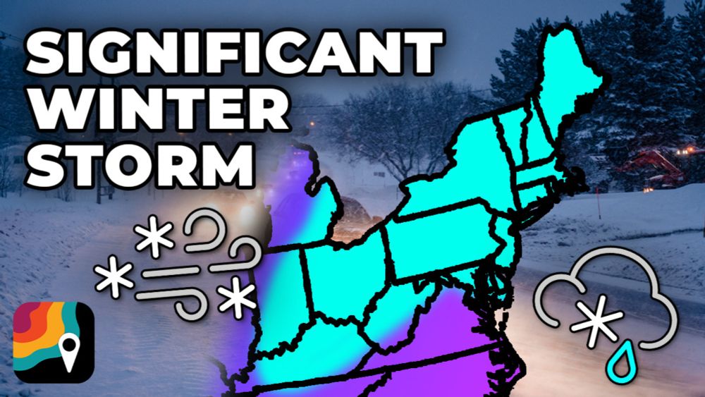
Eastern U.S. Winter Storm
A significant winter storm will develop beginning Monday night, then track up the Appalachians while impacting the eastern U.S. Accumulating snows are likely from Kentucky to Maine, with icing along I...
myradar.com
December 1, 2025 at 6:35 PM
❄️A significant winter storm will develop beginning Monday night, then track up the Appalachians while impacting the eastern U.S.
Accumulating snows are likely from Kentucky to Maine, with icing along Interstate 81.
Meteorologist @matthewcappucci.bsky.social has an update.
myradar.com/videos/6275
Accumulating snows are likely from Kentucky to Maine, with icing along Interstate 81.
Meteorologist @matthewcappucci.bsky.social has an update.
myradar.com/videos/6275
Here's a look at expected ice accretions in western Virginia and eastern West Virginia.
Locally up to a quarter inch. That will cause slick and dangerous travel.
It may LOOK wet but really be ice.
Locally up to a quarter inch. That will cause slick and dangerous travel.
It may LOOK wet but really be ice.

December 1, 2025 at 5:15 PM
Here's a look at expected ice accretions in western Virginia and eastern West Virginia.
Locally up to a quarter inch. That will cause slick and dangerous travel.
It may LOOK wet but really be ice.
Locally up to a quarter inch. That will cause slick and dangerous travel.
It may LOOK wet but really be ice.
Classic freezing rain sounding (profile) in western Virginia for Tuesday morning.
A "warm nose" at the mid levels guarantees liquid falls, but freezing/subfreezing surface layer promotes freezing and ice accretion at ground.
A "warm nose" at the mid levels guarantees liquid falls, but freezing/subfreezing surface layer promotes freezing and ice accretion at ground.

December 1, 2025 at 5:15 PM
Classic freezing rain sounding (profile) in western Virginia for Tuesday morning.
A "warm nose" at the mid levels guarantees liquid falls, but freezing/subfreezing surface layer promotes freezing and ice accretion at ground.
A "warm nose" at the mid levels guarantees liquid falls, but freezing/subfreezing surface layer promotes freezing and ice accretion at ground.
Growing concern for the I-81 corridor in western Virginia on Tuesday morning, as well as the Alleghenies of eastern West Virginia.
Freezing rain/freezing drizzle will make for very treacherous travel.
Freezing rain/freezing drizzle will make for very treacherous travel.

December 1, 2025 at 5:14 PM
Growing concern for the I-81 corridor in western Virginia on Tuesday morning, as well as the Alleghenies of eastern West Virginia.
Freezing rain/freezing drizzle will make for very treacherous travel.
Freezing rain/freezing drizzle will make for very treacherous travel.