


Met4Cast
@met4cast.net
UK WEATHER UPDATES | No drama, just weather | Making complex weather understandable | 20+ years of studying | Sensible forecasts without the hype ❌
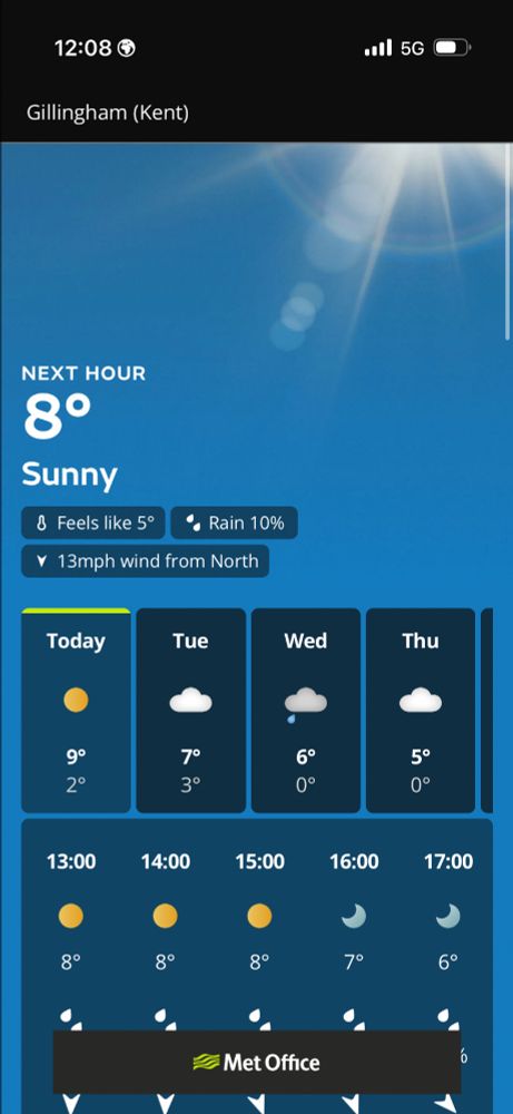
I really hope the Met Office see some sense and scrap this new app.
The design remains awful, completely lacking in data and.. worse still, this is what the warnings look like. How are you supposed to see which warning is which?
Just awful.
The design remains awful, completely lacking in data and.. worse still, this is what the warnings look like. How are you supposed to see which warning is which?
Just awful.

November 17, 2025 at 12:17 PM
I really hope the Met Office see some sense and scrap this new app.
The design remains awful, completely lacking in data and.. worse still, this is what the warnings look like. How are you supposed to see which warning is which?
Just awful.
The design remains awful, completely lacking in data and.. worse still, this is what the warnings look like. How are you supposed to see which warning is which?
Just awful.
A somewhat unfortunate drawing of the lines there..
November 17, 2025 at 11:20 AM
A somewhat unfortunate drawing of the lines there..
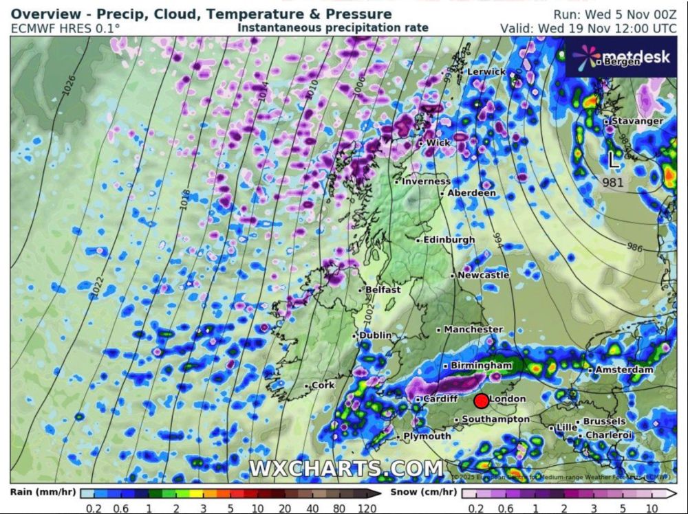
🚨 Locally severe weather possible tomorrow.
An easterly flow within the broader area of rainfall will intensify rainfall along eastern Welsh hills via orographic lift leading to a lot of water flowing into rivers downhill.
Totals of >100mm possible locally.
An easterly flow within the broader area of rainfall will intensify rainfall along eastern Welsh hills via orographic lift leading to a lot of water flowing into rivers downhill.
Totals of >100mm possible locally.

November 13, 2025 at 2:43 PM
🚨 Locally severe weather possible tomorrow.
An easterly flow within the broader area of rainfall will intensify rainfall along eastern Welsh hills via orographic lift leading to a lot of water flowing into rivers downhill.
Totals of >100mm possible locally.
An easterly flow within the broader area of rainfall will intensify rainfall along eastern Welsh hills via orographic lift leading to a lot of water flowing into rivers downhill.
Totals of >100mm possible locally.
Potentially quite a significant rain event shaping up for Friday.
A waving weather front could bring locally very high totals across the hills of Wales for example with totals likely exceeding 100mm and widely 30-50mm across central England.
Would expect Met Office warnings ⚠️
A waving weather front could bring locally very high totals across the hills of Wales for example with totals likely exceeding 100mm and widely 30-50mm across central England.
Would expect Met Office warnings ⚠️


November 12, 2025 at 8:40 AM
Potentially quite a significant rain event shaping up for Friday.
A waving weather front could bring locally very high totals across the hills of Wales for example with totals likely exceeding 100mm and widely 30-50mm across central England.
Would expect Met Office warnings ⚠️
A waving weather front could bring locally very high totals across the hills of Wales for example with totals likely exceeding 100mm and widely 30-50mm across central England.
Would expect Met Office warnings ⚠️
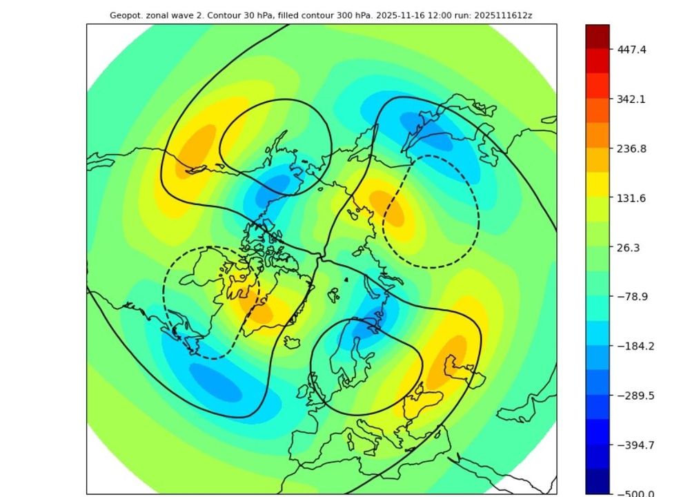
Absolute textbook example of anti-cyclonic wave breaking in the next few days leading to a cut off area of high pressure over Greenland.
November 11, 2025 at 5:51 PM
Absolute textbook example of anti-cyclonic wave breaking in the next few days leading to a cut off area of high pressure over Greenland.
Cold December?
MJO eastwards propagation and the associated +ve AAM tendency has driven a Pac Jet extension resulting in Atlantic / Greenland blocking next week.
This block will likely relax by the 26th/27th with a brief Atlantic interlude before further blocking develops into December.
MJO eastwards propagation and the associated +ve AAM tendency has driven a Pac Jet extension resulting in Atlantic / Greenland blocking next week.
This block will likely relax by the 26th/27th with a brief Atlantic interlude before further blocking develops into December.


November 11, 2025 at 3:36 PM
Cold December?
MJO eastwards propagation and the associated +ve AAM tendency has driven a Pac Jet extension resulting in Atlantic / Greenland blocking next week.
This block will likely relax by the 26th/27th with a brief Atlantic interlude before further blocking develops into December.
MJO eastwards propagation and the associated +ve AAM tendency has driven a Pac Jet extension resulting in Atlantic / Greenland blocking next week.
This block will likely relax by the 26th/27th with a brief Atlantic interlude before further blocking develops into December.
❄️❄️
Cold and potentially wintry weather arrives next week so naturally I've been dusting off and tweaking the snow graphics.
This is an example, but probably also does well to highlight the broader snow risks next week.
Cold and potentially wintry weather arrives next week so naturally I've been dusting off and tweaking the snow graphics.
This is an example, but probably also does well to highlight the broader snow risks next week.

November 11, 2025 at 2:48 PM
❄️❄️
Cold and potentially wintry weather arrives next week so naturally I've been dusting off and tweaking the snow graphics.
This is an example, but probably also does well to highlight the broader snow risks next week.
Cold and potentially wintry weather arrives next week so naturally I've been dusting off and tweaking the snow graphics.
This is an example, but probably also does well to highlight the broader snow risks next week.
Potential for some locally high rainfall totals across Wales in the coming days as a frontal wave pushes in.
Localised flooding / swollen rivers a possibility.
(The WxCharts redesign is very nice)
Localised flooding / swollen rivers a possibility.
(The WxCharts redesign is very nice)


November 11, 2025 at 1:54 PM
Potential for some locally high rainfall totals across Wales in the coming days as a frontal wave pushes in.
Localised flooding / swollen rivers a possibility.
(The WxCharts redesign is very nice)
Localised flooding / swollen rivers a possibility.
(The WxCharts redesign is very nice)
Modelling is certainly struggling at the moment, today’s EC46 comes tantalisingly close to a minor reversal!

November 5, 2025 at 10:17 PM
Modelling is certainly struggling at the moment, today’s EC46 comes tantalisingly close to a minor reversal!
The overnight ECM manages to find the cold.. ❄️
Still too far off to be chasing any cold with little support but does show that cold / snow is possible at the time of year we’re keeping an eye on.
Still too far off to be chasing any cold with little support but does show that cold / snow is possible at the time of year we’re keeping an eye on.

November 5, 2025 at 10:13 AM
The overnight ECM manages to find the cold.. ❄️
Still too far off to be chasing any cold with little support but does show that cold / snow is possible at the time of year we’re keeping an eye on.
Still too far off to be chasing any cold with little support but does show that cold / snow is possible at the time of year we’re keeping an eye on.
Beautiful example of a Rex Block on the GFS today.

November 4, 2025 at 8:54 PM
Beautiful example of a Rex Block on the GFS today.
Very interesting u-wind profile from the EC46 last night. Early December is usually a time when the sPV is strengthening so to see not only a significant weakening but many members going into major SSW territory is very interesting.
Last major SSW in early Decwas 1987.
Last Dec SSW was 2001.
Last major SSW in early Decwas 1987.
Last Dec SSW was 2001.

November 4, 2025 at 9:03 AM
Very interesting u-wind profile from the EC46 last night. Early December is usually a time when the sPV is strengthening so to see not only a significant weakening but many members going into major SSW territory is very interesting.
Last major SSW in early Decwas 1987.
Last Dec SSW was 2001.
Last major SSW in early Decwas 1987.
Last Dec SSW was 2001.
Blocky.
A Pacific jet extension associated with a recent strong +EAMT event will generate a Rossby wave train, these will propagate east eventually allowing for anticyclonic wave breaking in the Atlantic.
I.E high pressure building / turning settled.
A Pacific jet extension associated with a recent strong +EAMT event will generate a Rossby wave train, these will propagate east eventually allowing for anticyclonic wave breaking in the Atlantic.
I.E high pressure building / turning settled.


November 4, 2025 at 8:49 AM
Blocky.
A Pacific jet extension associated with a recent strong +EAMT event will generate a Rossby wave train, these will propagate east eventually allowing for anticyclonic wave breaking in the Atlantic.
I.E high pressure building / turning settled.
A Pacific jet extension associated with a recent strong +EAMT event will generate a Rossby wave train, these will propagate east eventually allowing for anticyclonic wave breaking in the Atlantic.
I.E high pressure building / turning settled.
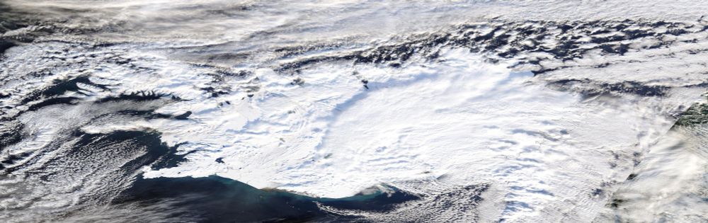
Iceland is really living up to it's name currently.
Following on from record breaking heat earlier this year, Iceland has recorded record breaking amounts of snow for the time of year, Reykjavík for example has recorded 40CM of snowfall.
Iceland bucking the current very warm Arctic trend.
Following on from record breaking heat earlier this year, Iceland has recorded record breaking amounts of snow for the time of year, Reykjavík for example has recorded 40CM of snowfall.
Iceland bucking the current very warm Arctic trend.
October 30, 2025 at 10:15 AM
Iceland is really living up to it's name currently.
Following on from record breaking heat earlier this year, Iceland has recorded record breaking amounts of snow for the time of year, Reykjavík for example has recorded 40CM of snowfall.
Iceland bucking the current very warm Arctic trend.
Following on from record breaking heat earlier this year, Iceland has recorded record breaking amounts of snow for the time of year, Reykjavík for example has recorded 40CM of snowfall.
Iceland bucking the current very warm Arctic trend.
On the left, the first ever hurricane captured by satellite category 5 Hurricane Esther in 1961 to today with this image of category 5 Hurricane Mellisa.
We have come a very, very long way in the last 64 years.
We have come a very, very long way in the last 64 years.


October 28, 2025 at 9:57 PM
On the left, the first ever hurricane captured by satellite category 5 Hurricane Esther in 1961 to today with this image of category 5 Hurricane Mellisa.
We have come a very, very long way in the last 64 years.
We have come a very, very long way in the last 64 years.
Hurricane Melissa is a record breaker.
210kt gust recorded above the surface setting a new world record, previous was 209kts by Typhoon Megi (2010)
The eye is now down to -5.21 making it the driest eye in Atlantic basin history, the world record is -5.00.
What a beast.
210kt gust recorded above the surface setting a new world record, previous was 209kts by Typhoon Megi (2010)
The eye is now down to -5.21 making it the driest eye in Atlantic basin history, the world record is -5.00.
What a beast.

October 27, 2025 at 4:10 PM
Hurricane Melissa is a record breaker.
210kt gust recorded above the surface setting a new world record, previous was 209kts by Typhoon Megi (2010)
The eye is now down to -5.21 making it the driest eye in Atlantic basin history, the world record is -5.00.
What a beast.
210kt gust recorded above the surface setting a new world record, previous was 209kts by Typhoon Megi (2010)
The eye is now down to -5.21 making it the driest eye in Atlantic basin history, the world record is -5.00.
What a beast.
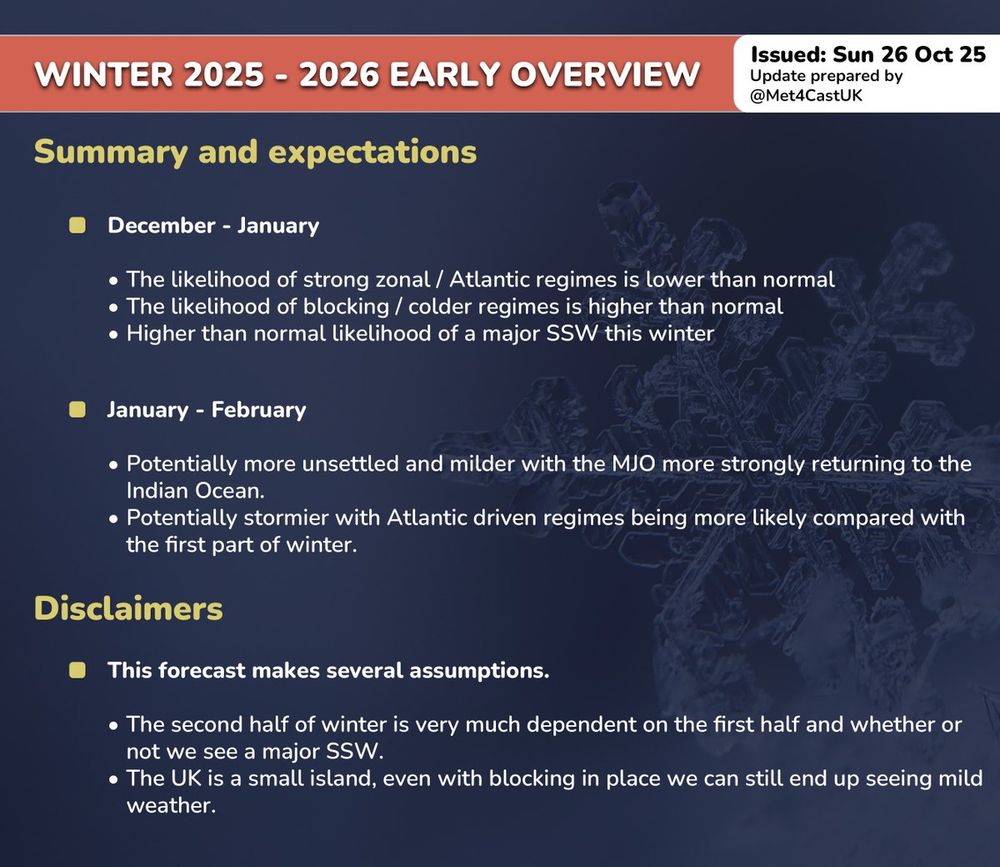
Key takeaway from my early winter thoughts this year for the UK.
October 27, 2025 at 11:13 AM
Key takeaway from my early winter thoughts this year for the UK.
I'm sorry but..
What the hell is this new Met Office website design language? It looks like something from the early 2000's but somehow.. worse? Why so large? Why so limited in terms of the data it shows? Why such huge spacing between things?
What the hell is this new Met Office website design language? It looks like something from the early 2000's but somehow.. worse? Why so large? Why so limited in terms of the data it shows? Why such huge spacing between things?


October 23, 2025 at 8:46 PM
I'm sorry but..
What the hell is this new Met Office website design language? It looks like something from the early 2000's but somehow.. worse? Why so large? Why so limited in terms of the data it shows? Why such huge spacing between things?
What the hell is this new Met Office website design language? It looks like something from the early 2000's but somehow.. worse? Why so large? Why so limited in terms of the data it shows? Why such huge spacing between things?
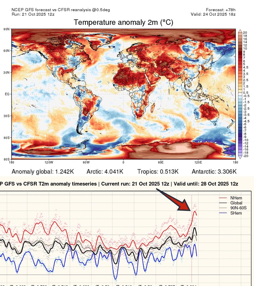
“The house is on fire. Act like it” - Greta Thunberg
A heatwave at a hemispheric level will spike in the coming days with NH temperatures likely to be 1.8-2.0°C above pre-industrial levels, the warmest they've been this year.
A heatwave at a hemispheric level will spike in the coming days with NH temperatures likely to be 1.8-2.0°C above pre-industrial levels, the warmest they've been this year.
October 21, 2025 at 6:37 PM
“The house is on fire. Act like it” - Greta Thunberg
A heatwave at a hemispheric level will spike in the coming days with NH temperatures likely to be 1.8-2.0°C above pre-industrial levels, the warmest they've been this year.
A heatwave at a hemispheric level will spike in the coming days with NH temperatures likely to be 1.8-2.0°C above pre-industrial levels, the warmest they've been this year.
I for one welcome our new low pressure overlord.
Quite a wet night across part of Ireland with Dublin seeing >40mm of rain. This ushers in our upcoming spell of wet & potentially windy weather 🌧️
BUT! There will be some sunshine too.. ☀️
Quite a wet night across part of Ireland with Dublin seeing >40mm of rain. This ushers in our upcoming spell of wet & potentially windy weather 🌧️
BUT! There will be some sunshine too.. ☀️

October 19, 2025 at 9:54 AM
I for one welcome our new low pressure overlord.
Quite a wet night across part of Ireland with Dublin seeing >40mm of rain. This ushers in our upcoming spell of wet & potentially windy weather 🌧️
BUT! There will be some sunshine too.. ☀️
Quite a wet night across part of Ireland with Dublin seeing >40mm of rain. This ushers in our upcoming spell of wet & potentially windy weather 🌧️
BUT! There will be some sunshine too.. ☀️
It's grey again today by the way but change is coming.
Through tonight and tomorrow a band of rain will slowly move eastwards ushering in a spell of unsettled weather. Locally wet & potentially windy at times over the next 7-10 days.
Autumn is here.
Through tonight and tomorrow a band of rain will slowly move eastwards ushering in a spell of unsettled weather. Locally wet & potentially windy at times over the next 7-10 days.
Autumn is here.

October 18, 2025 at 8:52 AM
It's grey again today by the way but change is coming.
Through tonight and tomorrow a band of rain will slowly move eastwards ushering in a spell of unsettled weather. Locally wet & potentially windy at times over the next 7-10 days.
Autumn is here.
Through tonight and tomorrow a band of rain will slowly move eastwards ushering in a spell of unsettled weather. Locally wet & potentially windy at times over the next 7-10 days.
Autumn is here.
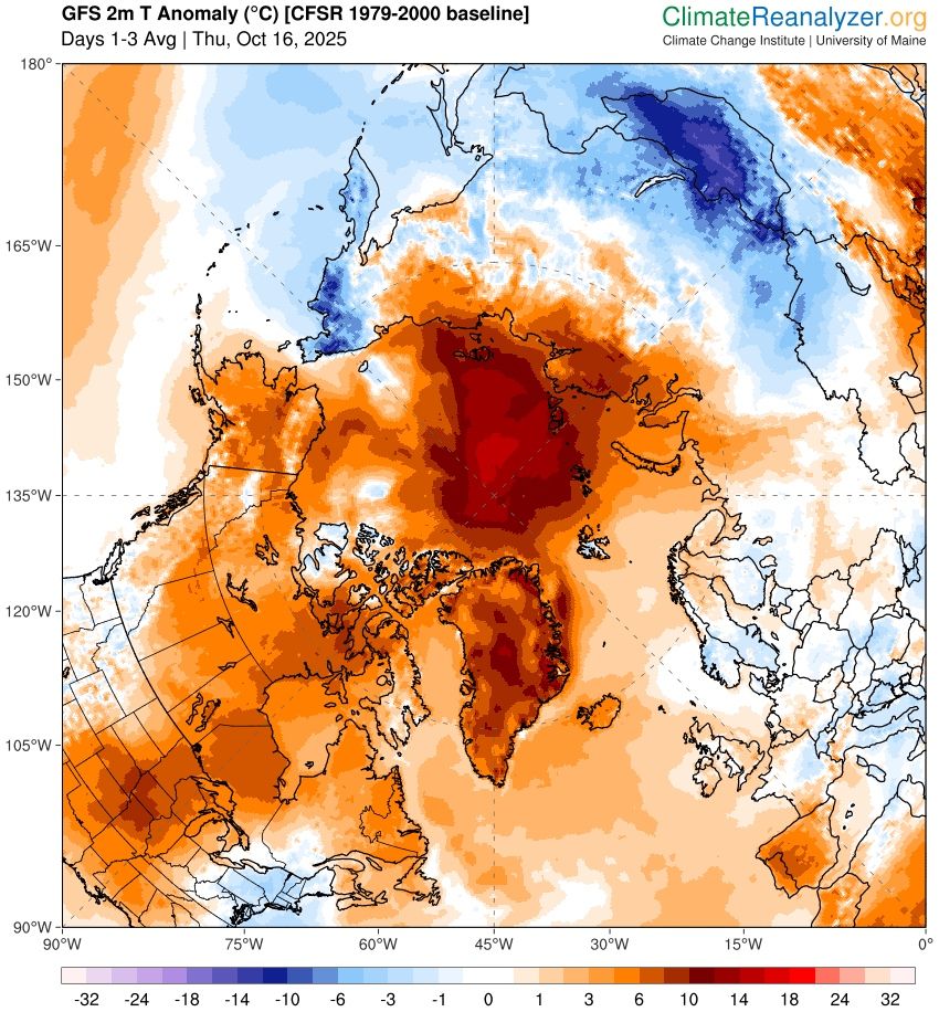
The entire Arctic region is significantly above average and this is having an impact on ice re-freezing.
Northerlies are becoming less cold in the UK, a rapidly warming Arctic & shrinking ice is part of the reason and is consistent with climate change.
Northerlies are becoming less cold in the UK, a rapidly warming Arctic & shrinking ice is part of the reason and is consistent with climate change.
October 16, 2025 at 10:44 AM
The entire Arctic region is significantly above average and this is having an impact on ice re-freezing.
Northerlies are becoming less cold in the UK, a rapidly warming Arctic & shrinking ice is part of the reason and is consistent with climate change.
Northerlies are becoming less cold in the UK, a rapidly warming Arctic & shrinking ice is part of the reason and is consistent with climate change.
Britons opening their curtains for the next 4 months.

October 15, 2025 at 10:17 AM
Britons opening their curtains for the next 4 months.
Growing signs that low pressure will return around the 21st/22nd bringing some much needed rainfall across the UK.
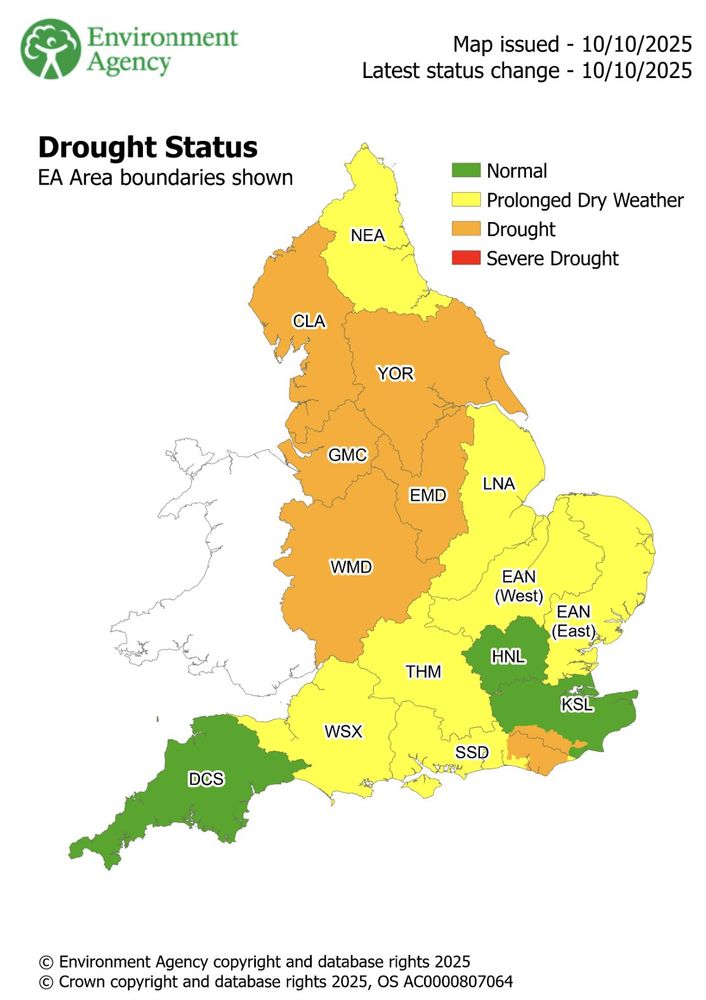
The Environment Agency have declared drought status in a number of areas across England.
The Environment Agency have declared drought status in a number of areas across England.

October 13, 2025 at 7:05 PM
Growing signs that low pressure will return around the 21st/22nd bringing some much needed rainfall across the UK.
The Environment Agency have declared drought status in a number of areas across England.
The Environment Agency have declared drought status in a number of areas across England.
Planet earth is very sick and it’s our fault.
We are destroying the natural world and burning it, this is causing the temperatures to rise and the climate to begin shifting into something today’s life on earth is not evolved for or adapt to quickly enough.
We are destroying the natural world and burning it, this is causing the temperatures to rise and the climate to begin shifting into something today’s life on earth is not evolved for or adapt to quickly enough.

October 11, 2025 at 6:27 PM
Planet earth is very sick and it’s our fault.
We are destroying the natural world and burning it, this is causing the temperatures to rise and the climate to begin shifting into something today’s life on earth is not evolved for or adapt to quickly enough.
We are destroying the natural world and burning it, this is causing the temperatures to rise and the climate to begin shifting into something today’s life on earth is not evolved for or adapt to quickly enough.