


Mark Bove
@mcb-wxclimaterisk.bsky.social
25 Year veteran insurance industry meteorologist. Natural hazards, weather, climate, catastrophe risk management and modeling. Building codes and resilience. Expect the occasional pupnado pic. Meteorologist for Munich Re US. All opinions my own. 🏳️🌈🇺🇦
Reposted by Mark Bove

Climate change DEFINITELY affects hurricane:
STRENGTH: Warmer water is hurricane food
RAINFALL: Warm air holds more water vapor
SURGE: Warmer water expands, warmer ice melts, sea levels rise
PREDICTION: hotter seas mean faster intensification
STRENGTH: Warmer water is hurricane food
RAINFALL: Warm air holds more water vapor
SURGE: Warmer water expands, warmer ice melts, sea levels rise
PREDICTION: hotter seas mean faster intensification
October 28, 2025 at 1:48 PM
Climate change DEFINITELY affects hurricane:
STRENGTH: Warmer water is hurricane food
RAINFALL: Warm air holds more water vapor
SURGE: Warmer water expands, warmer ice melts, sea levels rise
PREDICTION: hotter seas mean faster intensification
STRENGTH: Warmer water is hurricane food
RAINFALL: Warm air holds more water vapor
SURGE: Warmer water expands, warmer ice melts, sea levels rise
PREDICTION: hotter seas mean faster intensification
Reposted by Mark Bove

The western end of Jamaica where #Melissa is projected to make landfall has the least well-built structures of anyplace on the island. Graphic is from a 2021 paper, "Poverty and hurricane risk exposure in Jamaica": www.researchgate.net/publication/...

October 28, 2025 at 1:53 AM
The western end of Jamaica where #Melissa is projected to make landfall has the least well-built structures of anyplace on the island. Graphic is from a 2021 paper, "Poverty and hurricane risk exposure in Jamaica": www.researchgate.net/publication/...
Reposted by Mark Bove

Received a few questions regarding insurance in Jamaica. Roughly 20% of residential properties currently have insurance. However. Of that ~20%, a remarkable 95% of those properties are "underinsured" -- or not insured for the full value of their home. #Melissa
jamaica-gleaner.com/article/news...
jamaica-gleaner.com/article/news...
IAJ sounds alarm as 95% of J’can homes underinsured amid hurricane season
With the 2025 hurricane now under way, the Insurance Association of Jamaica (IAJ) has launched a new public education campaign urging Jamaican property owners, both locally and abroad, to urgently reassess their insurance coverage before disaster...
jamaica-gleaner.com
October 28, 2025 at 10:11 PM
Received a few questions regarding insurance in Jamaica. Roughly 20% of residential properties currently have insurance. However. Of that ~20%, a remarkable 95% of those properties are "underinsured" -- or not insured for the full value of their home. #Melissa
jamaica-gleaner.com/article/news...
jamaica-gleaner.com/article/news...
Reposted by Mark Bove
#Melissa: It is not hyperbolic to say that parts of western and central Jamaica will be unrecognizable once the storm passes. This is one of the strongest known tropical cyclones to make landfall anywhere in the world.
And.
Yet another example of a strengthening storm up to the point of landfall.
And.
Yet another example of a strengthening storm up to the point of landfall.

October 28, 2025 at 2:22 PM
#Melissa: It is not hyperbolic to say that parts of western and central Jamaica will be unrecognizable once the storm passes. This is one of the strongest known tropical cyclones to make landfall anywhere in the world.
And.
Yet another example of a strengthening storm up to the point of landfall.
And.
Yet another example of a strengthening storm up to the point of landfall.
For @catinsight.bsky.social: here are my full results using 4 RI thresholds by decade. If you want underlying data send me an email.

October 28, 2025 at 2:31 PM
For @catinsight.bsky.social: here are my full results using 4 RI thresholds by decade. If you want underlying data send me an email.
Reposted by Mark Bove

North Atlantic TCs achieving 150-kt maximum winds since 1966 (the satellite era):
Camille (1969): 150 kt, 905 hPa
Anita (1977): 150 kt, 926 hPa
David (1979): 150 kt, 924 hPa
Allen (1980): 165 kt, 899 hPa
Gilbert (1988): 160 kt, 888 hPa
Andrew (1992): 150 kt, 922 hPa
Mitch (1998): 155 kt, 905 hPa
Camille (1969): 150 kt, 905 hPa
Anita (1977): 150 kt, 926 hPa
David (1979): 150 kt, 924 hPa
Allen (1980): 165 kt, 899 hPa
Gilbert (1988): 160 kt, 888 hPa
Andrew (1992): 150 kt, 922 hPa
Mitch (1998): 155 kt, 905 hPa
October 27, 2025 at 7:57 PM
North Atlantic TCs achieving 150-kt maximum winds since 1966 (the satellite era):
Camille (1969): 150 kt, 905 hPa
Anita (1977): 150 kt, 926 hPa
David (1979): 150 kt, 924 hPa
Allen (1980): 165 kt, 899 hPa
Gilbert (1988): 160 kt, 888 hPa
Andrew (1992): 150 kt, 922 hPa
Mitch (1998): 155 kt, 905 hPa
Camille (1969): 150 kt, 905 hPa
Anita (1977): 150 kt, 926 hPa
David (1979): 150 kt, 924 hPa
Allen (1980): 165 kt, 899 hPa
Gilbert (1988): 160 kt, 888 hPa
Andrew (1992): 150 kt, 922 hPa
Mitch (1998): 155 kt, 905 hPa
My jaw dropped. Frightening display of power tonight by Melissa. Please stay safe Jamaica.
October 28, 2025 at 1:20 AM
My jaw dropped. Frightening display of power tonight by Melissa. Please stay safe Jamaica.
Atlantic TCs undergoing an RI period of at least 60kts/24 hours by decade. Substantial increase in the extreme tail of the RI distribution in the past 25 years.

October 27, 2025 at 9:51 PM
Atlantic TCs undergoing an RI period of at least 60kts/24 hours by decade. Substantial increase in the extreme tail of the RI distribution in the past 25 years.
No kings rally, Hightstown, NJ


October 18, 2025 at 3:36 PM
No kings rally, Hightstown, NJ
Reposted by Mark Bove

I wrote about how Hurricane Katrina helped spur pretty remarkable improvements in hurricane forecasts since 20 years ago and how current and planned budget cuts by the Trump administration to research could set us back.

Katrina Helped Revolutionize Hurricane Forecasting. Budget Cuts May Set Us Back
Hurricane forecasts have made huge leaps since Katrina hit 20 years ago, but that progress is threatened by Trump administration cuts to research
www.scientificamerican.com
August 29, 2025 at 2:31 PM
I wrote about how Hurricane Katrina helped spur pretty remarkable improvements in hurricane forecasts since 20 years ago and how current and planned budget cuts by the Trump administration to research could set us back.
Reposted by Mark Bove

Fires started on private lands and transmitted to public are more damaging than the reverse - relatively uncommon for destructive fires to start in public wildlands and spread to private communities. Fig 6 is esp striking.
www.nature.com/articles/s41...
HT @jaishrijuice.bsky.social for re-upping
www.nature.com/articles/s41...
HT @jaishrijuice.bsky.social for re-upping

August 29, 2025 at 5:03 PM
Fires started on private lands and transmitted to public are more damaging than the reverse - relatively uncommon for destructive fires to start in public wildlands and spread to private communities. Fig 6 is esp striking.
www.nature.com/articles/s41...
HT @jaishrijuice.bsky.social for re-upping
www.nature.com/articles/s41...
HT @jaishrijuice.bsky.social for re-upping
Remembering Katrina, 20 years later. Here’s a few of (imo) my more compelling photos on-site from post-event surveys in September 2005 and February 2006.


August 29, 2025 at 2:00 PM
Remembering Katrina, 20 years later. Here’s a few of (imo) my more compelling photos on-site from post-event surveys in September 2005 and February 2006.
My article on Katrina, 20 years later.
Couldn’t cover every facet of this historic event in just 1,500 words. I focus on the fact that risk isn’t static…and continues to rise.
www.munichre.com/en/insights/...
Couldn’t cover every facet of this historic event in just 1,500 words. I focus on the fact that risk isn’t static…and continues to rise.
www.munichre.com/en/insights/...

Katrina's lasting legacy: Exploring the evolving risk landscape along the northern Gulf Coast | Munich Re
Twenty years have passed since Hurricane Katrina became the most destructive hurricane in US history, producing an inflation-adjusted US$ 205 billion in overall losses, of which roughly half was insur...
www.munichre.com
August 29, 2025 at 1:38 PM
My article on Katrina, 20 years later.
Couldn’t cover every facet of this historic event in just 1,500 words. I focus on the fact that risk isn’t static…and continues to rise.
www.munichre.com/en/insights/...
Couldn’t cover every facet of this historic event in just 1,500 words. I focus on the fact that risk isn’t static…and continues to rise.
www.munichre.com/en/insights/...
Reposted by Mark Bove
#Erin becomes the 7th Atlantic storm in the Satellite Era (1966-present) to reach 150 mph by August 16.
1969: Camille (Aug 16)
1980: Allen (Aug 4)
2004: Charley (Aug 13)
2005: Dennis (Jul 8)
2005: Emily (Jul 17)
2024: Beryl (Jul 1)
2025: Erin (Aug 16)
FYI: Don't write a season off in early August.
1969: Camille (Aug 16)
1980: Allen (Aug 4)
2004: Charley (Aug 13)
2005: Dennis (Jul 8)
2005: Emily (Jul 17)
2024: Beryl (Jul 1)
2025: Erin (Aug 16)
FYI: Don't write a season off in early August.
August 16, 2025 at 1:08 PM
#Erin becomes the 7th Atlantic storm in the Satellite Era (1966-present) to reach 150 mph by August 16.
1969: Camille (Aug 16)
1980: Allen (Aug 4)
2004: Charley (Aug 13)
2005: Dennis (Jul 8)
2005: Emily (Jul 17)
2024: Beryl (Jul 1)
2025: Erin (Aug 16)
FYI: Don't write a season off in early August.
1969: Camille (Aug 16)
1980: Allen (Aug 4)
2004: Charley (Aug 13)
2005: Dennis (Jul 8)
2005: Emily (Jul 17)
2024: Beryl (Jul 1)
2025: Erin (Aug 16)
FYI: Don't write a season off in early August.
Reposted by Mark Bove

Erin’s radius of maximum wind (RMW) is only about 9km this morning. That is exceptionally small and characteristic of high-end rapid intensification in pretty much any basin.
At this rate, category 5 intensity is likely by later this morning or early afternoon.
At this rate, category 5 intensity is likely by later this morning or early afternoon.

August 16, 2025 at 1:21 PM
Erin’s radius of maximum wind (RMW) is only about 9km this morning. That is exceptionally small and characteristic of high-end rapid intensification in pretty much any basin.
At this rate, category 5 intensity is likely by later this morning or early afternoon.
At this rate, category 5 intensity is likely by later this morning or early afternoon.
Reposted by Mark Bove
Erin's currently estimated increase from 75 kt to 130 kt intensity (maximum sustained wind anywhere in the hurricane) in **12 hours** is a 55-kt change exceeded by only three Atlantic hurricanes in the past 50 years: 2005 Wilma (75 kt!), 2007 Felix (60 kt), and 2024 Milton (60 kt).
August 16, 2025 at 1:53 PM
Erin's currently estimated increase from 75 kt to 130 kt intensity (maximum sustained wind anywhere in the hurricane) in **12 hours** is a 55-kt change exceeded by only three Atlantic hurricanes in the past 50 years: 2005 Wilma (75 kt!), 2007 Felix (60 kt), and 2024 Milton (60 kt).
Reposted by Mark Bove

Reminder that the Tsunami Warning Centers are part of the National Weather Service. It would be nice to have them fully funded.
July 30, 2025 at 2:29 AM
Reminder that the Tsunami Warning Centers are part of the National Weather Service. It would be nice to have them fully funded.
Reposted by Mark Bove

Tomorrow: Save NOAA Labs event, hosted by Boulder Public Library. Speakers, including CIRES' Laura Riihimaki, will brief Congressman Neguse on work happening at NOAA Boulder labs & why it matters.
🗓️: July 12
🕙: 10:15 am
📍: Canyon Theater, Main Library
calendar.boulderlibrary.org/event/14927555
🗓️: July 12
🕙: 10:15 am
📍: Canyon Theater, Main Library
calendar.boulderlibrary.org/event/14927555

Save NOAA Labs
The Administration is proposing to zero-out funding for the NOAA labs in Boulder and other operations for the Office of Oceanic & Atmospheric Research. Speakers will brief...
calendar.boulderlibrary.org
July 11, 2025 at 8:15 PM
Tomorrow: Save NOAA Labs event, hosted by Boulder Public Library. Speakers, including CIRES' Laura Riihimaki, will brief Congressman Neguse on work happening at NOAA Boulder labs & why it matters.
🗓️: July 12
🕙: 10:15 am
📍: Canyon Theater, Main Library
calendar.boulderlibrary.org/event/14927555
🗓️: July 12
🕙: 10:15 am
📍: Canyon Theater, Main Library
calendar.boulderlibrary.org/event/14927555
Speaking of Katrina +20, this is important new work on subsidence rates in New Orleans and its impacts on the city’s critical levee system.
www.science.org/doi/10.1126/...
www.science.org/doi/10.1126/...

Vertical land motion in Greater New Orleans: Insights into underlying drivers and impact to flood protection infrastructure
Satellites provide perspective on the sustainability of New Orleans.
www.science.org
July 12, 2025 at 1:38 AM
Speaking of Katrina +20, this is important new work on subsidence rates in New Orleans and its impacts on the city’s critical levee system.
www.science.org/doi/10.1126/...
www.science.org/doi/10.1126/...
Everything’s horrible so here’s some cuteness from the pupnado.

July 12, 2025 at 12:49 AM
Everything’s horrible so here’s some cuteness from the pupnado.
Reposted by Mark Bove
Remarkable! "Purposely driving or walking into floodwaters accounts for more than 86% of total U.S. flood fatalities." Flash flooding the most deadly flood type; males more likely to be killed in floods than females; ages <30 the most vulnerable to floods. www.mdpi.com/2073-4441/13...
www.mdpi.com
July 11, 2025 at 6:44 PM
Remarkable! "Purposely driving or walking into floodwaters accounts for more than 86% of total U.S. flood fatalities." Flash flooding the most deadly flood type; males more likely to be killed in floods than females; ages <30 the most vulnerable to floods. www.mdpi.com/2073-4441/13...
As horrible as the Guadeloupe River flash flood was, it was an isolated small scale event.
FEMA couldn’t even handle that.
Imagine the call volume that’ll be generated (and not answered) when a major hurricane hits a populated area, possibly just weeks from now.
FEMA couldn’t even handle that.
Imagine the call volume that’ll be generated (and not answered) when a major hurricane hits a populated area, possibly just weeks from now.

I do not know how disaster survivors will ever make it through recovery in this administration — many couldn’t do it when there were people who cared in power— it’s infinitely worse now.
www.nytimes.com/2025/07/11/c...
www.nytimes.com/2025/07/11/c...

FEMA Didn’t Answer Thousands of Calls From Flood Survivors, Documents Show
www.nytimes.com
July 12, 2025 at 12:38 AM
As horrible as the Guadeloupe River flash flood was, it was an isolated small scale event.
FEMA couldn’t even handle that.
Imagine the call volume that’ll be generated (and not answered) when a major hurricane hits a populated area, possibly just weeks from now.
FEMA couldn’t even handle that.
Imagine the call volume that’ll be generated (and not answered) when a major hurricane hits a populated area, possibly just weeks from now.
Reposted by Mark Bove
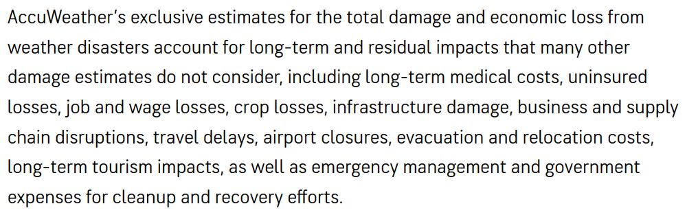
Respected outlets continue to quote these estimates. Why?
2018 California Wildfires: $400B
2024 Hurricane Season: $500B
2025 California Wildfires: $250-275B
April 2025 US SCS: $80-90B
These include wild guesses about future secondary / tertiary financial impacts. Has anyone ever sought validation?
2018 California Wildfires: $400B
2024 Hurricane Season: $500B
2025 California Wildfires: $250-275B
April 2025 US SCS: $80-90B
These include wild guesses about future secondary / tertiary financial impacts. Has anyone ever sought validation?
July 11, 2025 at 5:52 PM
Respected outlets continue to quote these estimates. Why?
2018 California Wildfires: $400B
2024 Hurricane Season: $500B
2025 California Wildfires: $250-275B
April 2025 US SCS: $80-90B
These include wild guesses about future secondary / tertiary financial impacts. Has anyone ever sought validation?
2018 California Wildfires: $400B
2024 Hurricane Season: $500B
2025 California Wildfires: $250-275B
April 2025 US SCS: $80-90B
These include wild guesses about future secondary / tertiary financial impacts. Has anyone ever sought validation?
Reposted by Mark Bove

Journalists and others, take note: this is an excellent, comprehensive, and up-to-date perspective on the still-escalating threats to NOAA beyond the NWS. NWS remains in pretty dire straits, yet the prospects for the rest of NOAA are actually even more dire (especially with respect to climate).

ICYMI: I wrote about the likely demise of the federal government's climate website (and how it's demise could be better than other end states) and why I am even more worried about the rest of NOAA beyond just NWS.
substack.com/@balancedwea...
substack.com/@balancedwea...
NOAA is not just the National Weather Service
Looking at the broader expanse of the National Oceanic and Atmospheric Administration
substack.com
June 14, 2025 at 4:01 AM
Journalists and others, take note: this is an excellent, comprehensive, and up-to-date perspective on the still-escalating threats to NOAA beyond the NWS. NWS remains in pretty dire straits, yet the prospects for the rest of NOAA are actually even more dire (especially with respect to climate).
Scenes from No Kings rally in Trenton, NJ


June 14, 2025 at 7:17 PM
Scenes from No Kings rally in Trenton, NJ