


Karen Capria 🦋
@kcapria.bsky.social
Maps, cartography, science.
Reposted by Karen Capria 🦋

Tech legend Jack Dangermond founded Esri in 1969. Now 80 years young and with a net worth of $10B+, he's still "all in" on his company and global mission.
@upstarts.bsky.social spent an hour with Jack this week for one of our best interviews yet, full of lessons on startup-building and life.
@upstarts.bsky.social spent an hour with Jack this week for one of our best interviews yet, full of lessons on startup-building and life.

Esri Founder Jack Dangermond's 'Secrets' To Building A Legendary Business
The 80-year-old software billionaire shares startup and life lessons that have kept him "all in" while running a high-impact global business for 50+ years.
www.upstartsmedia.com
August 28, 2025 at 2:27 PM
Tech legend Jack Dangermond founded Esri in 1969. Now 80 years young and with a net worth of $10B+, he's still "all in" on his company and global mission.
@upstarts.bsky.social spent an hour with Jack this week for one of our best interviews yet, full of lessons on startup-building and life.
@upstarts.bsky.social spent an hour with Jack this week for one of our best interviews yet, full of lessons on startup-building and life.
The livestream is happening now for #EsriUC2025. Watch with #GIS users from around the world! uc2025.esri.com/flow/esri/25... #mapping #science #analytics

2025 Esri User Conference | Esri
Join us for the 2025 Esri User Conference. Learn about the latest advancements in GIS from Esri experts, industry leaders, & your peers from around the globe.
uc2025.esri.com
July 14, 2025 at 3:26 PM
The livestream is happening now for #EsriUC2025. Watch with #GIS users from around the world! uc2025.esri.com/flow/esri/25... #mapping #science #analytics
The ArcGIS StoryMaps team is planning an excellent webinar that will help unpack the creative process for your stories. Explore, learn, and be inspired: storyscape-esriwhere.hub.arcgis.com/pages/commun...
#ArcGIS #storymaps #GIS #community
#ArcGIS #storymaps #GIS #community

March 28, 2025 at 9:05 PM
The ArcGIS StoryMaps team is planning an excellent webinar that will help unpack the creative process for your stories. Explore, learn, and be inspired: storyscape-esriwhere.hub.arcgis.com/pages/commun...
#ArcGIS #storymaps #GIS #community
#ArcGIS #storymaps #GIS #community
Explore the latest 5-year estimate American Community Survey data (2019-2023) from the U.S. Census Bureau in a collection of curated Atlas Instant Apps.
Demographics
Social Characteristics
Economic Characteristics
Housing, and
All Characteristics
www.esri.com/arcgis-blog/... #LivingAtlas #GIS
Demographics
Social Characteristics
Economic Characteristics
Housing, and
All Characteristics
www.esri.com/arcgis-blog/... #LivingAtlas #GIS

Introducing the American Community Survey (ACS) Atlas Collection
Introducing the new American Community Survey (ACS) Atlas collection, a group of 5 Atlas Instant Apps highlighting ACS maps in the Living Atlas.
www.esri.com
February 20, 2025 at 9:46 PM
Explore the latest 5-year estimate American Community Survey data (2019-2023) from the U.S. Census Bureau in a collection of curated Atlas Instant Apps.
Demographics
Social Characteristics
Economic Characteristics
Housing, and
All Characteristics
www.esri.com/arcgis-blog/... #LivingAtlas #GIS
Demographics
Social Characteristics
Economic Characteristics
Housing, and
All Characteristics
www.esri.com/arcgis-blog/... #LivingAtlas #GIS
The Citizen Voting Age Population (CVAP), is the population that is both 18 years or older and a U.S. citizen. All CVAP content in ArcGIS Living Atlas now contains and displays the latest vintage: 2019-2023. www.esri.com/arcgis-blog/...

Map and analyze updated Citizen Voting Age Population (CVAP) content in ArcGIS Living Atlas
2019-2023 Citizen Voting Age Population (CVAP) data layers and maps now available.
www.esri.com
February 20, 2025 at 7:35 PM
The Citizen Voting Age Population (CVAP), is the population that is both 18 years or older and a U.S. citizen. All CVAP content in ArcGIS Living Atlas now contains and displays the latest vintage: 2019-2023. www.esri.com/arcgis-blog/...
Reposted by Karen Capria 🦋

Reminder! We're still accepting nominations!
In collaboration with Esri, WiGIS will recognize the contributions of women to geospatial fields and award scholarships for undergraduate, graduate, and practitioners/researchers.
apply by February 28, 2025
womeningis.wildapricot.org/2025AS
#GISChat
In collaboration with Esri, WiGIS will recognize the contributions of women to geospatial fields and award scholarships for undergraduate, graduate, and practitioners/researchers.
apply by February 28, 2025
womeningis.wildapricot.org/2025AS
#GISChat

February 4, 2025 at 7:38 PM
Reminder! We're still accepting nominations!
In collaboration with Esri, WiGIS will recognize the contributions of women to geospatial fields and award scholarships for undergraduate, graduate, and practitioners/researchers.
apply by February 28, 2025
womeningis.wildapricot.org/2025AS
#GISChat
In collaboration with Esri, WiGIS will recognize the contributions of women to geospatial fields and award scholarships for undergraduate, graduate, and practitioners/researchers.
apply by February 28, 2025
womeningis.wildapricot.org/2025AS
#GISChat
Iconic bridges such as the Golden Gate or Brooklyn Bridge are favorite spots for tourists, but they are also a critical part of the nation's expansive ground transportation infrastructure. storymaps.arcgis.com/stories/92b2... #GIS #Esri #storymap

The secret life of bridges
Examine the historical evolution and current state of bridges across the United States in this interactive, map-based story.
storymaps.arcgis.com
February 4, 2025 at 6:37 PM
Iconic bridges such as the Golden Gate or Brooklyn Bridge are favorite spots for tourists, but they are also a critical part of the nation's expansive ground transportation infrastructure. storymaps.arcgis.com/stories/92b2... #GIS #Esri #storymap
The collaboration between Taylor Guitars and UCLA’s Congo Basin Institute (CBI) demonstrates how partnerships working toward the greater good can be found, even in the unlikeliest of places. storymaps.arcgis.com/collections/... #ArcGIS #StoryMaps

January 28, 2025 at 4:58 PM
The collaboration between Taylor Guitars and UCLA’s Congo Basin Institute (CBI) demonstrates how partnerships working toward the greater good can be found, even in the unlikeliest of places. storymaps.arcgis.com/collections/... #ArcGIS #StoryMaps
Head to the Science & Environment Showcase at the Esri Federal GIS Conference to meet @deepseadawn.bsky.social, learn about her work, and get a signed copy of her book, Mapping the Deep. registration.esri.com/flow/esri/25... #GIS #mapping

January 27, 2025 at 3:30 PM
Head to the Science & Environment Showcase at the Esri Federal GIS Conference to meet @deepseadawn.bsky.social, learn about her work, and get a signed copy of her book, Mapping the Deep. registration.esri.com/flow/esri/25... #GIS #mapping
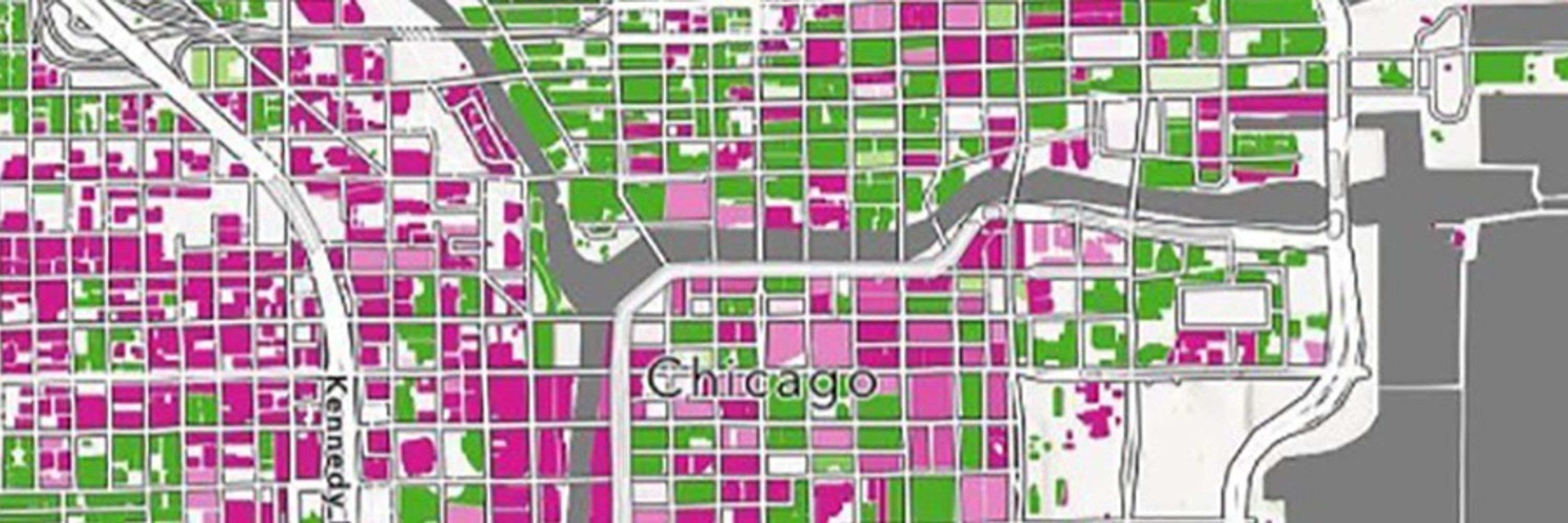
Interesting map animation. The most congested cities are listed at the end. www.maps.com/average-dail... #GIS

Which US Cities Have the Worst Traffic?
This animated map explores average daily traffic patterns for the 18 largest metropolitan areas in the US.
www.maps.com
January 24, 2025 at 6:41 PM
Interesting map animation. The most congested cities are listed at the end. www.maps.com/average-dail... #GIS
Reposted by Karen Capria 🦋

It's 19°F outside where I am (but feels like 10! 🫠). Publishing a blog post on mapping snow felt right... 🥶
www.esri.com/arcgis-blog/... #mapping #cartography
www.esri.com/arcgis-blog/... #mapping #cartography

How to Make Maps Fast (Using Snow Data!)
Learn how to make a map with SNODAS data in ArcGIS Pro and design a map quickly by planning ahead.
www.esri.com
January 21, 2025 at 5:27 PM
It's 19°F outside where I am (but feels like 10! 🫠). Publishing a blog post on mapping snow felt right... 🥶
www.esri.com/arcgis-blog/... #mapping #cartography
www.esri.com/arcgis-blog/... #mapping #cartography
This Drought Aware app provides information on drought-affected areas in the US, and integrates critical information including population, housing, river flow, reservoirs, crops, and agricultural labor. livingatlas.arcgis.com/drought-awar... #GIS #LivingAtlas

January 24, 2025 at 4:26 PM
This Drought Aware app provides information on drought-affected areas in the US, and integrates critical information including population, housing, river flow, reservoirs, crops, and agricultural labor. livingatlas.arcgis.com/drought-awar... #GIS #LivingAtlas
Join Esri's Chief Scientist @deepseadawn.bsky.social for a free course on how a geographic approach can help tackle a complex changing climate. www.esri.com/training/cat... #GIS #EsriTraining

January 23, 2025 at 4:05 PM
Join Esri's Chief Scientist @deepseadawn.bsky.social for a free course on how a geographic approach can help tackle a complex changing climate. www.esri.com/training/cat... #GIS #EsriTraining
You can search on Genasys Protect for an address or mapped zone to determine if an area is under evacuation. protect.genasys.com/search?z=14&... #California #wildfires

January 9, 2025 at 6:11 PM
You can search on Genasys Protect for an address or mapped zone to determine if an area is under evacuation. protect.genasys.com/search?z=14&... #California #wildfires
Homes in the United States are heated by a variety of fuels. Most homes rely on natural gas for heat, but oil, propane, electricity, and wood are also common. www.maps.com/home-heating... #GISchat

The Geography of Heating US Homes
Homes in the US are heated by a variety of fuels. The interplay of who, what, and where is on full display in this detailed map.
www.maps.com
December 16, 2024 at 6:35 PM
Homes in the United States are heated by a variety of fuels. Most homes rely on natural gas for heat, but oil, propane, electricity, and wood are also common. www.maps.com/home-heating... #GISchat
New blog by Lisa Berry on authoritative historical fire perimeter data from the California Department of Forestry and Fire Protection (CAL FIRE).
CAL FIRE offers this digital record as a ready-to-use layer within ArcGIS Living Atlas of the World.
www.esri.com/arcgis-blog/... #GISchat
CAL FIRE offers this digital record as a ready-to-use layer within ArcGIS Living Atlas of the World.
www.esri.com/arcgis-blog/... #GISchat

December 6, 2024 at 9:44 PM
New blog by Lisa Berry on authoritative historical fire perimeter data from the California Department of Forestry and Fire Protection (CAL FIRE).
CAL FIRE offers this digital record as a ready-to-use layer within ArcGIS Living Atlas of the World.
www.esri.com/arcgis-blog/... #GISchat
CAL FIRE offers this digital record as a ready-to-use layer within ArcGIS Living Atlas of the World.
www.esri.com/arcgis-blog/... #GISchat
Final day to enter the 2024 ArcGIS StoryMaps competition. Submit a story in one of five categories:
Digital Humanities
Health and Safety
Nature and Physical Science
Planning and Infrastructure
Humanitarian and Disaster Response
www.esri.com/en-us/arcgis... #GISChat
Digital Humanities
Health and Safety
Nature and Physical Science
Planning and Infrastructure
Humanitarian and Disaster Response
www.esri.com/en-us/arcgis... #GISChat

2024 ArcGIS StoryMaps Competition | Esri
Enter the 2024 ArcGIS StoryMaps Competition: Storytelling for a Better World. Get competition details and find inspiration for your story in our online gallery.
www.esri.com
December 6, 2024 at 4:44 PM
Final day to enter the 2024 ArcGIS StoryMaps competition. Submit a story in one of five categories:
Digital Humanities
Health and Safety
Nature and Physical Science
Planning and Infrastructure
Humanitarian and Disaster Response
www.esri.com/en-us/arcgis... #GISChat
Digital Humanities
Health and Safety
Nature and Physical Science
Planning and Infrastructure
Humanitarian and Disaster Response
www.esri.com/en-us/arcgis... #GISChat
In this new article Dawn Wright discusses the work of the 100 Island Challenge, the worldwide initiative which captured an ecological survey of coral reefs in the Pacific, Caribbean, and Indian oceans.
www.gpsworld.com/coral-reefs-...
@deepseadawn.bsky.social #GISchat #science
www.gpsworld.com/coral-reefs-...
@deepseadawn.bsky.social #GISchat #science

Coral reefs at a crossroads: "Every coral we see is fighting" - GPS World
This is a challenging time for coral reefs. Although they cover less than 0.1% of the ocean floor, coral reefs support 25% of all marine creatures.
www.gpsworld.com
December 5, 2024 at 9:07 PM
In this new article Dawn Wright discusses the work of the 100 Island Challenge, the worldwide initiative which captured an ecological survey of coral reefs in the Pacific, Caribbean, and Indian oceans.
www.gpsworld.com/coral-reefs-...
@deepseadawn.bsky.social #GISchat #science
www.gpsworld.com/coral-reefs-...
@deepseadawn.bsky.social #GISchat #science
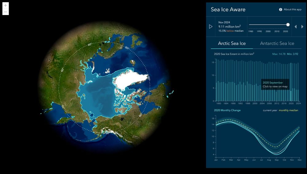
The Science— and joy — of snow and ice. Meet the people behind scientific expeditions and climate studies who inspire action to protect the landscapes we treasure.
Read the new issue of StoryScape from the ArcGIS StoryMaps team: storyscape-esriwhere.hub.arcgis.com #GISchat #science
Read the new issue of StoryScape from the ArcGIS StoryMaps team: storyscape-esriwhere.hub.arcgis.com #GISchat #science
December 5, 2024 at 6:30 PM
The Science— and joy — of snow and ice. Meet the people behind scientific expeditions and climate studies who inspire action to protect the landscapes we treasure.
Read the new issue of StoryScape from the ArcGIS StoryMaps team: storyscape-esriwhere.hub.arcgis.com #GISchat #science
Read the new issue of StoryScape from the ArcGIS StoryMaps team: storyscape-esriwhere.hub.arcgis.com #GISchat #science
The ArcGIS Living Atlas Policy Mapping team provides the GIS community with a collection of free layers with data from the US Census Bureau’s American Community Survey.
On December 12, the US Census Bureau will release its updated five-year estimates (2019-2023). www.esri.com/arcgis-blog/... #GIS
On December 12, the US Census Bureau will release its updated five-year estimates (2019-2023). www.esri.com/arcgis-blog/... #GIS

December 5, 2024 at 2:32 PM
The ArcGIS Living Atlas Policy Mapping team provides the GIS community with a collection of free layers with data from the US Census Bureau’s American Community Survey.
On December 12, the US Census Bureau will release its updated five-year estimates (2019-2023). www.esri.com/arcgis-blog/... #GIS
On December 12, the US Census Bureau will release its updated five-year estimates (2019-2023). www.esri.com/arcgis-blog/... #GIS
PortWatch is an open platform designed to help policymakers and the public assess the impact of maritime trade disruptions that result from natural disasters or other large-scale events.
The platform is a collaboration between the IMF and the University of Oxford. portwatch.imf.org #GIS #climate
The platform is a collaboration between the IMF and the University of Oxford. portwatch.imf.org #GIS #climate

November 27, 2024 at 3:33 PM
PortWatch is an open platform designed to help policymakers and the public assess the impact of maritime trade disruptions that result from natural disasters or other large-scale events.
The platform is a collaboration between the IMF and the University of Oxford. portwatch.imf.org #GIS #climate
The platform is a collaboration between the IMF and the University of Oxford. portwatch.imf.org #GIS #climate
Lake Champlain is fed with waters delivered by a large network of rivers and streams. The expansive watershed is known as the Lake Champlain Basin.
Organizations in communities throughout the Basin are helping to protect and restore their shared waters.
storymaps.arcgis.com/stories/5b36...
Organizations in communities throughout the Basin are helping to protect and restore their shared waters.
storymaps.arcgis.com/stories/5b36...

Summit to Shore
Celebrating and Protecting the Waters of the Lake Champlain Basin
storymaps.arcgis.com
November 26, 2024 at 7:56 PM
Lake Champlain is fed with waters delivered by a large network of rivers and streams. The expansive watershed is known as the Lake Champlain Basin.
Organizations in communities throughout the Basin are helping to protect and restore their shared waters.
storymaps.arcgis.com/stories/5b36...
Organizations in communities throughout the Basin are helping to protect and restore their shared waters.
storymaps.arcgis.com/stories/5b36...
NOAA’s Damage Assessment, Remediation, and Restoration Program (DARRP) holds polluters accountable.
This story map shows the locations of pollution events where the program is pursuing protection and restoration of natural resources. storymaps.arcgis.com/stories/d9da... #GIS
This story map shows the locations of pollution events where the program is pursuing protection and restoration of natural resources. storymaps.arcgis.com/stories/d9da... #GIS

NOAA Pollution Assessment and Restoration in Your State
NOAA Damage Assessment, Remediation, and Restoration Program
storymaps.arcgis.com
November 26, 2024 at 6:10 PM
NOAA’s Damage Assessment, Remediation, and Restoration Program (DARRP) holds polluters accountable.
This story map shows the locations of pollution events where the program is pursuing protection and restoration of natural resources. storymaps.arcgis.com/stories/d9da... #GIS
This story map shows the locations of pollution events where the program is pursuing protection and restoration of natural resources. storymaps.arcgis.com/stories/d9da... #GIS
Can food security efforts also protect nature and fight climate change? A new study by Project Drawdown and the University of Minnesota says yes.
This story map gives insights into solutions, analysis and action. storymaps.arcgis.com/stories/35e0...
This story map gives insights into solutions, analysis and action. storymaps.arcgis.com/stories/35e0...

Improving Food Security in Senegal
Targeting Actions to Improve People's Lives, Protect Nature, and Mitigate Climate Change
storymaps.arcgis.com
November 26, 2024 at 4:37 PM
Can food security efforts also protect nature and fight climate change? A new study by Project Drawdown and the University of Minnesota says yes.
This story map gives insights into solutions, analysis and action. storymaps.arcgis.com/stories/35e0...
This story map gives insights into solutions, analysis and action. storymaps.arcgis.com/stories/35e0...
This course is free and provides practical techniques to elevate your spatial analysis. Sign up here: www.esri.com/training/cat... #Esri #GIS

November 25, 2024 at 7:32 PM
This course is free and provides practical techniques to elevate your spatial analysis. Sign up here: www.esri.com/training/cat... #Esri #GIS