


Jason Nicholls
@jnmet.bsky.social
Lead International Forecaster/Senior Meteorologist/International forecasting manager @AccuWeather. Long range/global forecaster. NVU-Lyndon grad; proud dad

For those making a fuss about Arabic numerals on social media. Arabic numerals, or more precisely, Hindu-Arabic numbers, were invented in India in the 5th century and then spread, becoming the numbers we use every day. Everyone in the US has been learning Arabic numbers since the nation's creation.

November 21, 2025 at 12:00 AM
For those making a fuss about Arabic numerals on social media. Arabic numerals, or more precisely, Hindu-Arabic numbers, were invented in India in the 5th century and then spread, becoming the numbers we use every day. Everyone in the US has been learning Arabic numbers since the nation's creation.
Madden-Julian Oscillation (MJO) remaining stalled in phase 6 could result in tropical development in the vicinity of the #Philippines this weekend or early next week. Regardless there cane be areas of heavy rain in portions of the Philippines early next week.
November 20, 2025 at 1:32 PM
Madden-Julian Oscillation (MJO) remaining stalled in phase 6 could result in tropical development in the vicinity of the #Philippines this weekend or early next week. Regardless there cane be areas of heavy rain in portions of the Philippines early next week.
Strong piece of energy digging into the Mediterranean Sea next week does raise concerns for the possibility of a medicane late next week.

November 20, 2025 at 12:09 PM
Strong piece of energy digging into the Mediterranean Sea next week does raise concerns for the possibility of a medicane late next week.
A fresh low will form in the southeast Bay of Bengal this weekend and can strengthen to a cyclonic storm before possibly impacting eastern #India later next week.
November 20, 2025 at 10:45 AM
A fresh low will form in the southeast Bay of Bengal this weekend and can strengthen to a cyclonic storm before possibly impacting eastern #India later next week.

Moist onshore flow will continue to produce areas of heavy rain in south-central #Vietnam into Saturday, local time. The heaviest rain & severe flooding will continue in Binh Dinh, Phu Yen & Khanh Hoa provinces. Over 600 mm (24 inches) of rain has already fallen since Sunday.
November 19, 2025 at 2:14 PM
Moist onshore flow will continue to produce areas of heavy rain in south-central #Vietnam into Saturday, local time. The heaviest rain & severe flooding will continue in Binh Dinh, Phu Yen & Khanh Hoa provinces. Over 600 mm (24 inches) of rain has already fallen since Sunday.
Risk of tropical development in the western Philippine Sea this weekend or early next week. There is a risk of impacts in the #Philippines early next week. Potential for additional development near the Mariana Islands next weekend or early Dec.


November 19, 2025 at 12:36 PM
Risk of tropical development in the western Philippine Sea this weekend or early next week. There is a risk of impacts in the #Philippines early next week. Potential for additional development near the Mariana Islands next weekend or early Dec.
Area of low pressure near #Lakshadweep will remain weak as it drifts west. A fresh low will form in the southern Bay of Bengal this weekend & can strengthen to a cyclonic storm before approaching #AndhraPradesh later next week.

November 19, 2025 at 10:43 AM
Area of low pressure near #Lakshadweep will remain weak as it drifts west. A fresh low will form in the southern Bay of Bengal this weekend & can strengthen to a cyclonic storm before approaching #AndhraPradesh later next week.
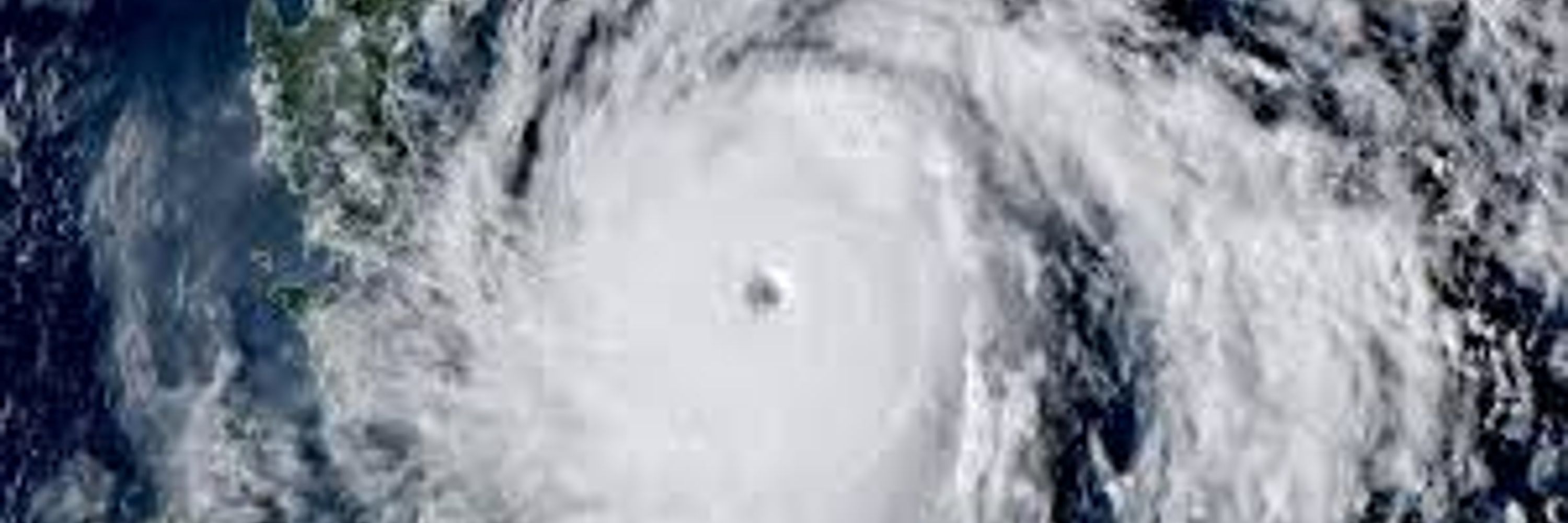
TC Fina is north-northeast of #Darwin and is forecast to make landfall on Saturday which would make it the 2nd earliest landfalling TC into #Australia just behind Ines in 1973.

November 19, 2025 at 8:34 AM
TC Fina is north-northeast of #Darwin and is forecast to make landfall on Saturday which would make it the 2nd earliest landfalling TC into #Australia just behind Ines in 1973.
Tropical Cyclone #Fina has formed in northern #Australia and is forecast to make landfall in the #TopEnd on Saturday, local time. This would make Fina the second earliest landfalling cyclone in Australia since the satellite era began in 1970. TC Ines in 1973 is the earliest.

November 18, 2025 at 9:43 PM
Tropical Cyclone #Fina has formed in northern #Australia and is forecast to make landfall in the #TopEnd on Saturday, local time. This would make Fina the second earliest landfalling cyclone in Australia since the satellite era began in 1970. TC Ines in 1973 is the earliest.


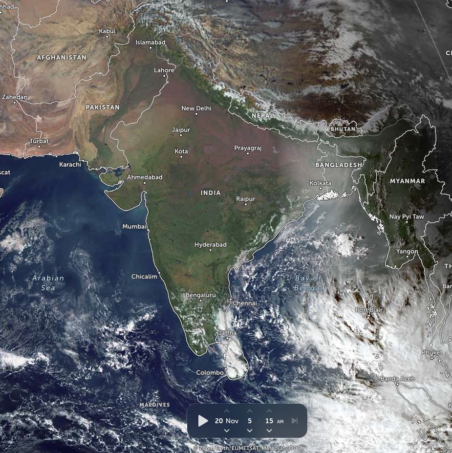
Low pressure near the southern tip of India will enhance rain in far southern #India into Wednesday as it drifts into the southeast Arabian Sea. A new low will form in the southern Bay of Bengal this weekend, then can impact southern India next week.

November 18, 2025 at 12:10 PM
Low pressure near the southern tip of India will enhance rain in far southern #India into Wednesday as it drifts into the southeast Arabian Sea. A new low will form in the southern Bay of Bengal this weekend, then can impact southern India next week.
Tropical low 02U off northern #Australia is expected to strengthen to a tropical cyclone before making landfall in the Top End around Friday or Saturday, local time.

November 18, 2025 at 9:13 AM
Tropical low 02U off northern #Australia is expected to strengthen to a tropical cyclone before making landfall in the Top End around Friday or Saturday, local time.
Latest Indian Ocean Dipole (IOD) weekly index is up to -0.99°C for the week ending 16 Nov. The IOD is expected to return to neutral in December.

November 17, 2025 at 3:30 PM
Latest Indian Ocean Dipole (IOD) weekly index is up to -0.99°C for the week ending 16 Nov. The IOD is expected to return to neutral in December.
A frontal boundary will continue to produce areas of heavy rain & strong thunderstorms in #Brazil from the states of #Parana to #SaoPaulo, southern #MinasGerais & parts of Rio de Janeiro into Tuesday.

November 17, 2025 at 1:10 PM
A frontal boundary will continue to produce areas of heavy rain & strong thunderstorms in #Brazil from the states of #Parana to #SaoPaulo, southern #MinasGerais & parts of Rio de Janeiro into Tuesday.
Tropical low 02U is northwest of #Darwin & can strengthen to a cyclone as it drifts east over the next few days. Low will bring areas of heavy rain to the Top End the rest of this week, then backs SSW & can bring heavier rain around the Joseph Bonaparte Gulf this weekend.

November 17, 2025 at 11:58 AM
Tropical low 02U is northwest of #Darwin & can strengthen to a cyclone as it drifts east over the next few days. Low will bring areas of heavy rain to the Top End the rest of this week, then backs SSW & can bring heavier rain around the Joseph Bonaparte Gulf this weekend.

A weak low will enhance rain in southern #AndhraPradesh, #TamilNadu, #Kerala, #Puducherry & #SriLanka into midweek. Another low will form in the southern Bay of Bengal this weekend & can strengthen before possibly impacting eastern #India next week.

November 17, 2025 at 8:57 AM
A weak low will enhance rain in southern #AndhraPradesh, #TamilNadu, #Kerala, #Puducherry & #SriLanka into midweek. Another low will form in the southern Bay of Bengal this weekend & can strengthen before possibly impacting eastern #India next week.
Tropical low 02U in the Timor Sea will gradually strengthen & can become a cyclone later this week. Regardless, areas of heavy rain are likely across #Australia's #TopEnd much of this week.

November 16, 2025 at 3:15 PM
Tropical low 02U in the Timor Sea will gradually strengthen & can become a cyclone later this week. Regardless, areas of heavy rain are likely across #Australia's #TopEnd much of this week.

Monitoring a tropical cyclone forming in the Timor Sea next week with a high chance of heavy rain across #Australia's #TopEnd.
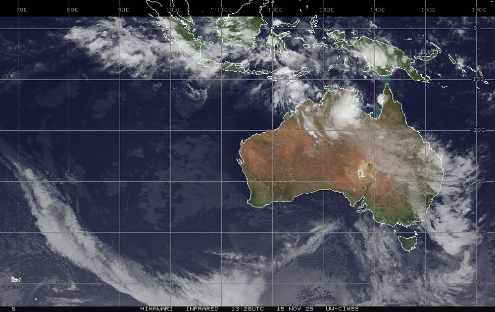
November 15, 2025 at 2:43 PM
Monitoring a tropical cyclone forming in the Timor Sea next week with a high chance of heavy rain across #Australia's #TopEnd.


More widespread & locally heavy rain expected in southern #AndhraPradesh, #TamilNadu, #Kerala, #Puducherry & #SriLanka early next week. Watching for development in southern Bay of Bengal late next week or early the following week. Risk of widespread heavy rain in S #India the week of 24 Nov.

November 14, 2025 at 12:31 PM
More widespread & locally heavy rain expected in southern #AndhraPradesh, #TamilNadu, #Kerala, #Puducherry & #SriLanka early next week. Watching for development in southern Bay of Bengal late next week or early the following week. Risk of widespread heavy rain in S #India the week of 24 Nov.