


Cameron H 🇦🇺
@hitchy04.bsky.social
Former North, now South QLD’er into Australian weather extremes/records, climate data visualisation, cyclones, and storm chasing.
Cold weather and soccer enjoyer
🟠⚫️ 🟢🟡
Cold weather and soccer enjoyer
🟠⚫️ 🟢🟡
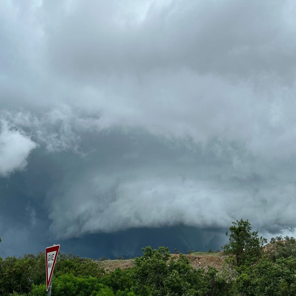
Captured these severe #thunderstorms as they pushed offshore in the #Brisbane area this evening.
Looked spectacular with the sun setting.
Looked spectacular with the sun setting.


November 27, 2025 at 8:44 AM
Captured these severe #thunderstorms as they pushed offshore in the #Brisbane area this evening.
Looked spectacular with the sun setting.
Looked spectacular with the sun setting.
The remnants of TC #Fina are still kicking in far north WA with another rain record falling yesterday.
Wyndham recorded 147.2mm- easily it's wettest Spring/November day since combined records began in 1898 (93.2mm 1986). A record start to the wet season.
Wettest Spring/Nov day in WA since 2001.
Wyndham recorded 147.2mm- easily it's wettest Spring/November day since combined records began in 1898 (93.2mm 1986). A record start to the wet season.
Wettest Spring/Nov day in WA since 2001.

November 26, 2025 at 5:00 AM
The remnants of TC #Fina are still kicking in far north WA with another rain record falling yesterday.
Wyndham recorded 147.2mm- easily it's wettest Spring/November day since combined records began in 1898 (93.2mm 1986). A record start to the wet season.
Wettest Spring/Nov day in WA since 2001.
Wyndham recorded 147.2mm- easily it's wettest Spring/November day since combined records began in 1898 (93.2mm 1986). A record start to the wet season.
Wettest Spring/Nov day in WA since 2001.
Not only does that smash the site's monthly/season record by 1.6c (32.6c 2008), it's an ALL-TIME record (34.1c Jan 2013).
Also 46.8c on Sunday, breaking the site's Spring 2006 record by 0.1c. POR 27yrs
Also 46.8c on Sunday, breaking the site's Spring 2006 record by 0.1c. POR 27yrs

November 25, 2025 at 5:13 AM
Not only does that smash the site's monthly/season record by 1.6c (32.6c 2008), it's an ALL-TIME record (34.1c Jan 2013).
Also 46.8c on Sunday, breaking the site's Spring 2006 record by 0.1c. POR 27yrs
Also 46.8c on Sunday, breaking the site's Spring 2006 record by 0.1c. POR 27yrs
After a cool start to Nov, W QLD returns to record heat.
Bedourie recorded a *34.2c* MINIMUM temp on Sunday night (prelim but very likely as 9am temp was 39.1c).
That's the *3rd hottest Spring/Nov night ever recorded in Australia*. Just 0.8c below state/national 1965 record!
More records likely.
Bedourie recorded a *34.2c* MINIMUM temp on Sunday night (prelim but very likely as 9am temp was 39.1c).
That's the *3rd hottest Spring/Nov night ever recorded in Australia*. Just 0.8c below state/national 1965 record!
More records likely.

November 25, 2025 at 5:13 AM
After a cool start to Nov, W QLD returns to record heat.
Bedourie recorded a *34.2c* MINIMUM temp on Sunday night (prelim but very likely as 9am temp was 39.1c).
That's the *3rd hottest Spring/Nov night ever recorded in Australia*. Just 0.8c below state/national 1965 record!
More records likely.
Bedourie recorded a *34.2c* MINIMUM temp on Sunday night (prelim but very likely as 9am temp was 39.1c).
That's the *3rd hottest Spring/Nov night ever recorded in Australia*. Just 0.8c below state/national 1965 record!
More records likely.
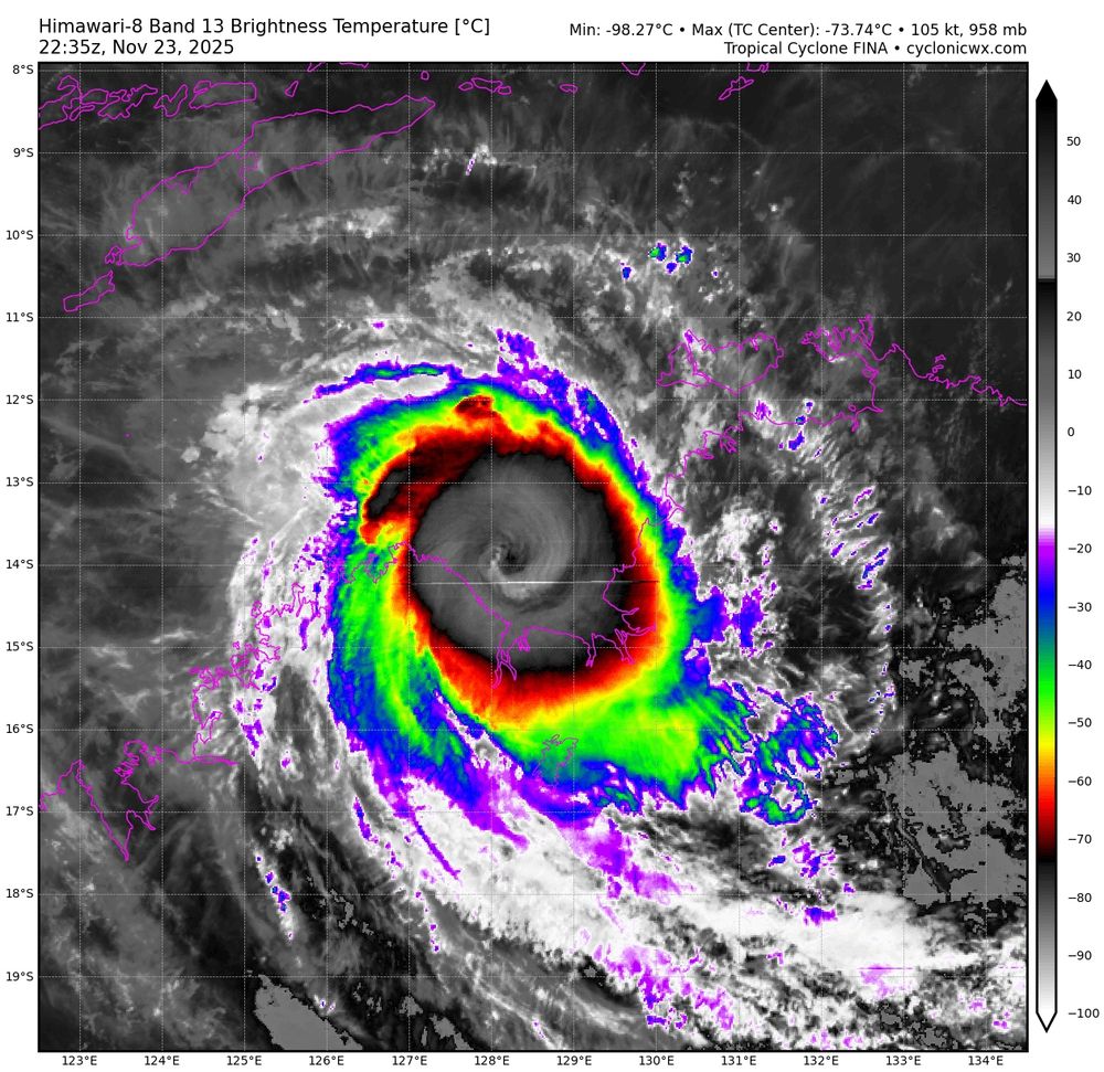
Cyclone #Fina made her final landfall at about 9:30pm AWST last night on a very remote part of the northern Kimberley coast as a severe category 3. W/ a ~7km wide eye
That’s the first November severe landfall since TC Quenton made landfall as a cat 4 in 1983.
What a cyclone.
That’s the first November severe landfall since TC Quenton made landfall as a cat 4 in 1983.
What a cyclone.

November 25, 2025 at 12:05 AM
Cyclone #Fina made her final landfall at about 9:30pm AWST last night on a very remote part of the northern Kimberley coast as a severe category 3. W/ a ~7km wide eye
That’s the first November severe landfall since TC Quenton made landfall as a cat 4 in 1983.
What a cyclone.
That’s the first November severe landfall since TC Quenton made landfall as a cat 4 in 1983.
What a cyclone.

Tiny Cyclone #Fina has been taking advantage of the extremely warm ocean in the JB Gulf, strengthening to a category 4 yesterday. Fair bit of lightning in eyewall still.
Due to a delayed weakening, Fina now forecast to make her final landfall as a cat 3 in remote N WA today.
Due to a delayed weakening, Fina now forecast to make her final landfall as a cat 3 in remote N WA today.
November 24, 2025 at 12:12 AM
Tiny Cyclone #Fina has been taking advantage of the extremely warm ocean in the JB Gulf, strengthening to a category 4 yesterday. Fair bit of lightning in eyewall still.
Due to a delayed weakening, Fina now forecast to make her final landfall as a cat 3 in remote N WA today.
Due to a delayed weakening, Fina now forecast to make her final landfall as a cat 3 in remote N WA today.
360mm fell in just 12hrs- the ALL-TIME NT 12hr record is 391mm! Insane for November
Other notable readings:
283.6mm Gunn Point
265.4mm Charles Point
204.8mm Knuckey Lagoon
Darwin AP 168.8mm, breaks the Oct 2020 Spring record of 119.4mm. Even old P.O site was lower (145.3mm way back in 1885!)
Other notable readings:
283.6mm Gunn Point
265.4mm Charles Point
204.8mm Knuckey Lagoon
Darwin AP 168.8mm, breaks the Oct 2020 Spring record of 119.4mm. Even old P.O site was lower (145.3mm way back in 1885!)

November 23, 2025 at 9:59 AM
360mm fell in just 12hrs- the ALL-TIME NT 12hr record is 391mm! Insane for November
Other notable readings:
283.6mm Gunn Point
265.4mm Charles Point
204.8mm Knuckey Lagoon
Darwin AP 168.8mm, breaks the Oct 2020 Spring record of 119.4mm. Even old P.O site was lower (145.3mm way back in 1885!)
Other notable readings:
283.6mm Gunn Point
265.4mm Charles Point
204.8mm Knuckey Lagoon
Darwin AP 168.8mm, breaks the Oct 2020 Spring record of 119.4mm. Even old P.O site was lower (145.3mm way back in 1885!)
Cyclone #Fina intensified into a cat 3 cyclone this morning and is now starting to clear out an eye signifying further intensification.
#Darwin to see worst conditions tonight/early AM
BOM now forecasts a cat 4 months peak over the JBG tomorrow partly thanks to very high OHC.
#Darwin to see worst conditions tonight/early AM
BOM now forecasts a cat 4 months peak over the JBG tomorrow partly thanks to very high OHC.


November 22, 2025 at 5:46 AM
#CycloneFina made a historic landfall at about 10:30pm overnight on the Cobourg Peninsula as a category 2.
Easily the earliest #cyclone landfall on record in the NT (TC Alessia Nov 27th 2013).
Also the 3rd earliest landfall nationally (hours later than Ines 1973, 01U 19th 1910).
Easily the earliest #cyclone landfall on record in the NT (TC Alessia Nov 27th 2013).
Also the 3rd earliest landfall nationally (hours later than Ines 1973, 01U 19th 1910).

November 22, 2025 at 12:47 AM
#CycloneFina made a historic landfall at about 10:30pm overnight on the Cobourg Peninsula as a category 2.
Easily the earliest #cyclone landfall on record in the NT (TC Alessia Nov 27th 2013).
Also the 3rd earliest landfall nationally (hours later than Ines 1973, 01U 19th 1910).
Easily the earliest #cyclone landfall on record in the NT (TC Alessia Nov 27th 2013).
Also the 3rd earliest landfall nationally (hours later than Ines 1973, 01U 19th 1910).
McCluer Island recorded a 83kmh/45kt gust early this morning. That breaks the 2016 76kmh November record at the station. POR 20yrs
Croker Island recorded 188.6mm yesterday- the 5th wettest November day on record in the NT!
Latest update has Fina just shy of category 2.
Croker Island recorded 188.6mm yesterday- the 5th wettest November day on record in the NT!
Latest update has Fina just shy of category 2.

November 21, 2025 at 1:30 AM
McCluer Island recorded a 83kmh/45kt gust early this morning. That breaks the 2016 76kmh November record at the station. POR 20yrs
Croker Island recorded 188.6mm yesterday- the 5th wettest November day on record in the NT!
Latest update has Fina just shy of category 2.
Croker Island recorded 188.6mm yesterday- the 5th wettest November day on record in the NT!
Latest update has Fina just shy of category 2.
#CycloneFina is a good example of just how quickly intensity can change with small cyclones.
Yesterday AM Fina briefly attempted to clear an eye until wind shear substantially increased, weakening Fina back to a cat 1. Now that shear is lower, she's intensifying again
Yesterday AM Fina briefly attempted to clear an eye until wind shear substantially increased, weakening Fina back to a cat 1. Now that shear is lower, she's intensifying again


November 21, 2025 at 1:30 AM
#CycloneFina is a good example of just how quickly intensity can change with small cyclones.
Yesterday AM Fina briefly attempted to clear an eye until wind shear substantially increased, weakening Fina back to a cat 1. Now that shear is lower, she's intensifying again
Yesterday AM Fina briefly attempted to clear an eye until wind shear substantially increased, weakening Fina back to a cat 1. Now that shear is lower, she's intensifying again
Our national broadcaster getting another simple weather fact wrong yet again.
Cyclone Alessia made landfall in 2013, *NOT* 2011.
How was this missed!
Cyclone Alessia made landfall in 2013, *NOT* 2011.
How was this missed!
November 20, 2025 at 1:25 AM
Our national broadcaster getting another simple weather fact wrong yet again.
Cyclone Alessia made landfall in 2013, *NOT* 2011.
How was this missed!
Cyclone Alessia made landfall in 2013, *NOT* 2011.
How was this missed!
Here's the latest track. Intensity is still very uncertain depending on land interaction, shear and dry air. From BOM technical bulletin, there's a moderate chance of a category 3.
TC watch now also includes #Darwin
TC watch now also includes #Darwin

November 19, 2025 at 11:49 PM
Here's the latest track. Intensity is still very uncertain depending on land interaction, shear and dry air. From BOM technical bulletin, there's a moderate chance of a category 3.
TC watch now also includes #Darwin
TC watch now also includes #Darwin
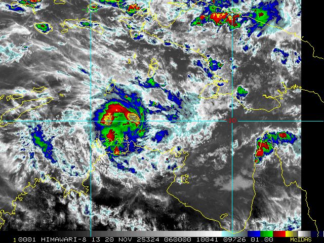
Despite ongoing easterly shear, #CycloneFina continues to intensify.
Despite not looking the greatest on satellite, she has been blowing up extremely powerful convection overnight. Constant -95c cloud tops peaking at -104.69c! Certainly quite rare in Aus (cyclonicwx.com).
TC warnings are now out.
Despite not looking the greatest on satellite, she has been blowing up extremely powerful convection overnight. Constant -95c cloud tops peaking at -104.69c! Certainly quite rare in Aus (cyclonicwx.com).
TC warnings are now out.
November 19, 2025 at 11:49 PM
Despite ongoing easterly shear, #CycloneFina continues to intensify.
Despite not looking the greatest on satellite, she has been blowing up extremely powerful convection overnight. Constant -95c cloud tops peaking at -104.69c! Certainly quite rare in Aus (cyclonicwx.com).
TC warnings are now out.
Despite not looking the greatest on satellite, she has been blowing up extremely powerful convection overnight. Constant -95c cloud tops peaking at -104.69c! Certainly quite rare in Aus (cyclonicwx.com).
TC warnings are now out.
Cyclone #Fina was named early this morning and a cyclone watch has been issued just now from Milingimbi to the Tiwi Islands.
Landfall expected on Friday AM on the Cobourg Peninsula as a category 2 and passing just north of #Darwin on Saturday
63kmh/34kt gust at McCluer Island this morning
Landfall expected on Friday AM on the Cobourg Peninsula as a category 2 and passing just north of #Darwin on Saturday
63kmh/34kt gust at McCluer Island this morning

November 19, 2025 at 1:27 AM
A painful 36.1c up in Townsville today (the hottest November day since 2019). Up to 38.5c at nearby Mt Stuart leading to several fires nearby.
Despite that, still a rather pleasant walk along the Ross River near Black Weir. Certainly much calmer compared to the Feb floods 🙃
Despite that, still a rather pleasant walk along the Ross River near Black Weir. Certainly much calmer compared to the Feb floods 🙃


November 18, 2025 at 1:29 PM
A painful 36.1c up in Townsville today (the hottest November day since 2019). Up to 38.5c at nearby Mt Stuart leading to several fires nearby.
Despite that, still a rather pleasant walk along the Ross River near Black Weir. Certainly much calmer compared to the Feb floods 🙃
Despite that, still a rather pleasant walk along the Ross River near Black Weir. Certainly much calmer compared to the Feb floods 🙃
Can just make out the centre of circulation on the edge of the Darwin radar.
After looking good early this morning on satellite, the system is struggling to maintain deep convection over the core today, largely occurring well to the north.
A small system can intensify and weaken very quickly.
After looking good early this morning on satellite, the system is struggling to maintain deep convection over the core today, largely occurring well to the north.
A small system can intensify and weaken very quickly.

November 18, 2025 at 2:53 AM
Can just make out the centre of circulation on the edge of the Darwin radar.
After looking good early this morning on satellite, the system is struggling to maintain deep convection over the core today, largely occurring well to the north.
A small system can intensify and weaken very quickly.
After looking good early this morning on satellite, the system is struggling to maintain deep convection over the core today, largely occurring well to the north.
A small system can intensify and weaken very quickly.
The first cyclone track map of the season is out with #02U #97S making landfall on Saturday AM on the Tiwi Islands as a category 2.
Due to its small size, there's significant intensity uncertainty. BOM technical report mentions a chance of category 3 intensity.
Next name is #Fina.
Due to its small size, there's significant intensity uncertainty. BOM technical report mentions a chance of category 3 intensity.
Next name is #Fina.

November 18, 2025 at 2:53 AM
Regardless of how TL #02U develops (BOM forecast now up to a 55%/high chance of forming by Fri AM!), heavy rain will be a significant threat for many days to come.

November 17, 2025 at 12:53 AM
Regardless of how TL #02U develops (BOM forecast now up to a 55%/high chance of forming by Fri AM!), heavy rain will be a significant threat for many days to come.
Strong rain gradient in the #Darwin area last 24hrs. The airport saw just 24.8mm, while Charles Point recorded an incredible 228.4mm!
That's the **3rd wettest November/Spring day ever recorded in the Northern Territory!**
Dum in Mirrie saw 170.6mm- a site March-November record (26yr POR)
That's the **3rd wettest November/Spring day ever recorded in the Northern Territory!**
Dum in Mirrie saw 170.6mm- a site March-November record (26yr POR)

November 17, 2025 at 12:53 AM
Strong rain gradient in the #Darwin area last 24hrs. The airport saw just 24.8mm, while Charles Point recorded an incredible 228.4mm!
That's the **3rd wettest November/Spring day ever recorded in the Northern Territory!**
Dum in Mirrie saw 170.6mm- a site March-November record (26yr POR)
That's the **3rd wettest November/Spring day ever recorded in the Northern Territory!**
Dum in Mirrie saw 170.6mm- a site March-November record (26yr POR)
TL #02U formed earlier. It remains to be seen if it will
a) intensify into a TC &
b) make landfall as a TC and join the very exclusive club.
Latest BOM forecast has a 35% chance of formation (moderate) by Saturday morning
a) intensify into a TC &
b) make landfall as a TC and join the very exclusive club.
Latest BOM forecast has a 35% chance of formation (moderate) by Saturday morning

November 16, 2025 at 2:19 PM
TL #02U formed earlier. It remains to be seen if it will
a) intensify into a TC &
b) make landfall as a TC and join the very exclusive club.
Latest BOM forecast has a 35% chance of formation (moderate) by Saturday morning
a) intensify into a TC &
b) make landfall as a TC and join the very exclusive club.
Latest BOM forecast has a 35% chance of formation (moderate) by Saturday morning
November TC landfalls are extremely rare in Australia.
In the satellite era, just 4 cyclones have hit Australia (only 3 excluding Cocos Islands). Most recently was Alessia in 2013.
On Nov 19th 1910 TC 01U hit Broome. TC Ines hit on Nov 21st 1973- the earliest recorded landfalls in a season
In the satellite era, just 4 cyclones have hit Australia (only 3 excluding Cocos Islands). Most recently was Alessia in 2013.
On Nov 19th 1910 TC 01U hit Broome. TC Ines hit on Nov 21st 1973- the earliest recorded landfalls in a season

November 16, 2025 at 2:19 PM
November TC landfalls are extremely rare in Australia.
In the satellite era, just 4 cyclones have hit Australia (only 3 excluding Cocos Islands). Most recently was Alessia in 2013.
On Nov 19th 1910 TC 01U hit Broome. TC Ines hit on Nov 21st 1973- the earliest recorded landfalls in a season
In the satellite era, just 4 cyclones have hit Australia (only 3 excluding Cocos Islands). Most recently was Alessia in 2013.
On Nov 19th 1910 TC 01U hit Broome. TC Ines hit on Nov 21st 1973- the earliest recorded landfalls in a season
The BOM is forecasting Tropical Low #02U to develop this weekend to the west of Darwin in the Timor Sea.
Currently only a 15% (low) chance of cyclonic development, but the forecast does mention “environmental conditions are supportive of significant development next week”.
Currently only a 15% (low) chance of cyclonic development, but the forecast does mention “environmental conditions are supportive of significant development next week”.

November 12, 2025 at 2:49 AM
The BOM is forecasting Tropical Low #02U to develop this weekend to the west of Darwin in the Timor Sea.
Currently only a 15% (low) chance of cyclonic development, but the forecast does mention “environmental conditions are supportive of significant development next week”.
Currently only a 15% (low) chance of cyclonic development, but the forecast does mention “environmental conditions are supportive of significant development next week”.