


Matt Forrest
@forrest.nyc
All things modern GIS. https://forrest.nyc/
Here are my top 5 geospatial Python libraries. Which would you add?
June 27, 2025 at 4:05 PM
Here are my top 5 geospatial Python libraries. Which would you add?
Reposted by Matt Forrest

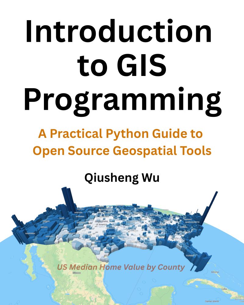
📣 Exciting News! I'm thrilled to announce the release of my new book: Introduction to GIS Programming: A Practical Python Guide to Open Source Geospatial Tools!
✨ What’s Included:
All code examples are freely available.
Access to 26 hours of free video tutorials to complement your learning.
✨ What’s Included:
All code examples are freely available.
Access to 26 hours of free video tutorials to complement your learning.
June 25, 2025 at 11:57 AM
📣 Exciting News! I'm thrilled to announce the release of my new book: Introduction to GIS Programming: A Practical Python Guide to Open Source Geospatial Tools!
✨ What’s Included:
All code examples are freely available.
Access to 26 hours of free video tutorials to complement your learning.
✨ What’s Included:
All code examples are freely available.
Access to 26 hours of free video tutorials to complement your learning.
Reposted by Matt Forrest

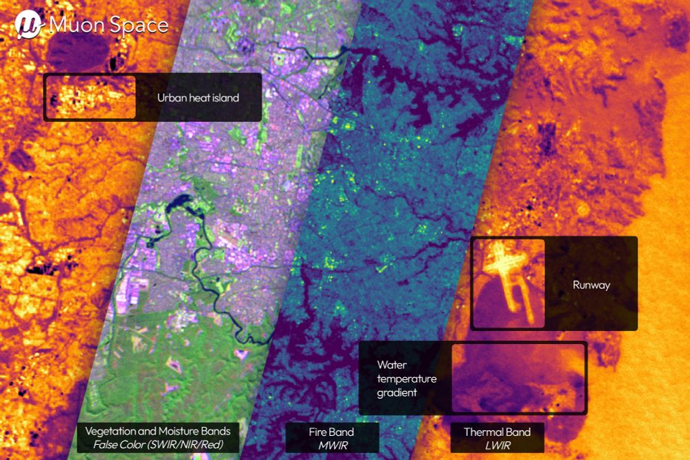
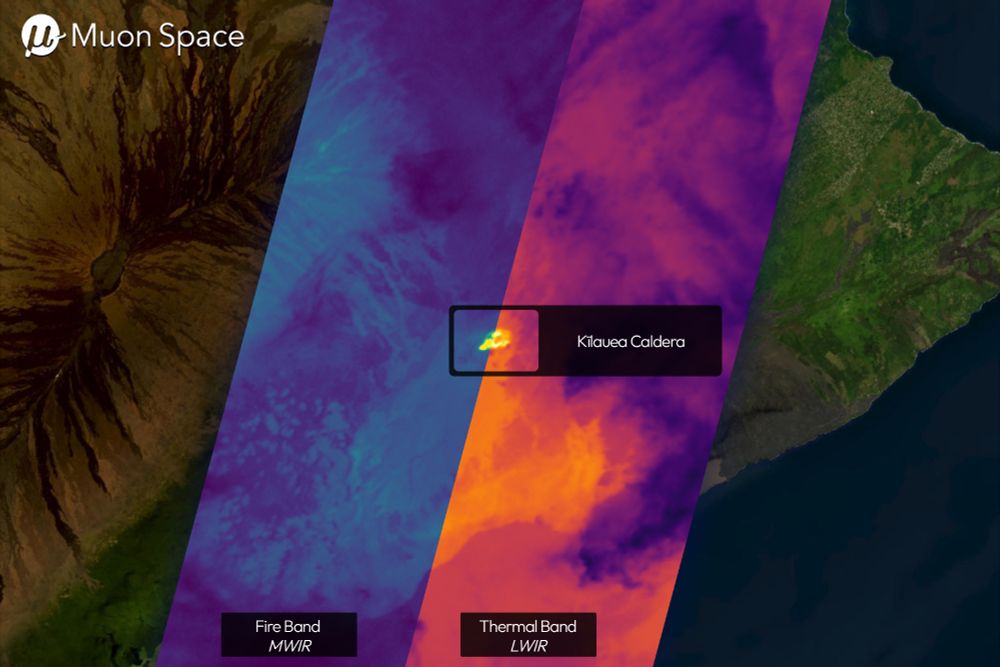
First light of thermal images from Muon Space/FireSat looking good: www.muonspace.com/press/muon-s...
🛰️🗺️
🛰️🗺️
June 26, 2025 at 9:04 PM
First light of thermal images from Muon Space/FireSat looking good: www.muonspace.com/press/muon-s...
🛰️🗺️
🛰️🗺️
Has anyone tried out the new SQL Rooms functionality from @foursquarecom.bsky.social? Looks pretty cool I must say!
sqlrooms.org
sqlrooms.org
SQLRooms
Build powerful analytics apps with DuckDB
sqlrooms.org
June 27, 2025 at 2:10 PM
Has anyone tried out the new SQL Rooms functionality from @foursquarecom.bsky.social? Looks pretty cool I must say!
sqlrooms.org
sqlrooms.org
For years I’ve watched smart and motivated GIS professionals struggle to keep up with modern tools.
Not because they’re not capable. But because the way we teach GIS hasn’t evolved with the technology.
Not because they’re not capable. But because the way we teach GIS hasn’t evolved with the technology.
June 27, 2025 at 3:50 AM
For years I’ve watched smart and motivated GIS professionals struggle to keep up with modern tools.
Not because they’re not capable. But because the way we teach GIS hasn’t evolved with the technology.
Not because they’re not capable. But because the way we teach GIS hasn’t evolved with the technology.
So I have a question - can you all help me understand the need or use cases for digital twins? Most of the ones that I see are 3D representations of a city or place, which is cool but what are they used for? And how can they create value?
January 29, 2025 at 3:13 PM
So I have a question - can you all help me understand the need or use cases for digital twins? Most of the ones that I see are 3D representations of a city or place, which is cool but what are they used for? And how can they create value?
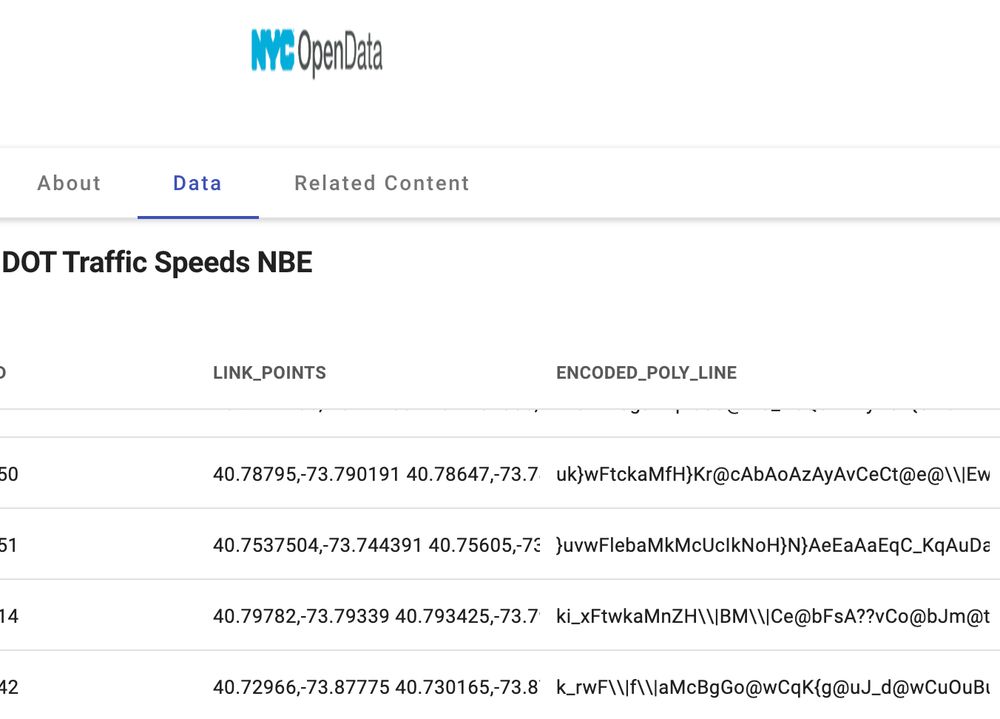
Encoded polylines and lat/lng pairs in reverse order in a STRING! Not cool NYC Open Data.
January 8, 2025 at 1:49 PM
Encoded polylines and lat/lng pairs in reverse order in a STRING! Not cool NYC Open Data.
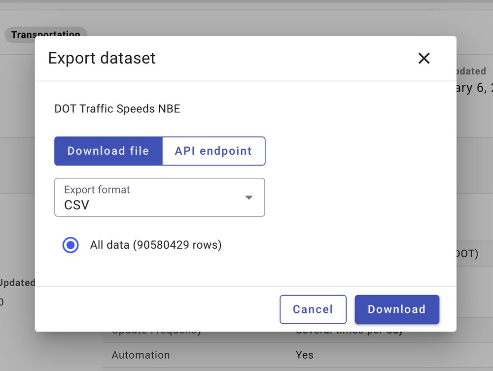
I wonder how far we can push NYC Open Data...
January 6, 2025 at 11:29 PM
I wonder how far we can push NYC Open Data...
🔮 What do you think the next year will hold for geospatial? Which areas are going to grow the most? What new companies are going to emerge? Here are my top 3 (share yours as well!):
December 13, 2024 at 5:34 PM
🔮 What do you think the next year will hold for geospatial? Which areas are going to grow the most? What new companies are going to emerge? Here are my top 3 (share yours as well!):
I’ve been exploring Esri’s approach to modern GIS and found some interesting signs of progress—but also some critical gaps. Let’s dive in. 🧵

December 9, 2024 at 8:43 PM
I’ve been exploring Esri’s approach to modern GIS and found some interesting signs of progress—but also some critical gaps. Let’s dive in. 🧵
Busy week but managed to get this video up today. Let me know what you think!
youtu.be/u1hIU0AsOFc?...
youtu.be/u1hIU0AsOFc?...

Spatial SQL Tools Explained: The Ultimate Guide
YouTube video by Matt Forrest
youtu.be
December 6, 2024 at 9:48 PM
Busy week but managed to get this video up today. Let me know what you think!
youtu.be/u1hIU0AsOFc?...
youtu.be/u1hIU0AsOFc?...
Here is one way I might summarize the live stream.

November 26, 2024 at 9:31 PM
Here is one way I might summarize the live stream.
ICYMI: Check out my livestream today announcing the Wherobots Series A and where we are headed next:
www.youtube.com/watch?v=_Mf6...
www.youtube.com/watch?v=_Mf6...

BREAKING: Special Livestream Announcment!
YouTube video by Matt Forrest
www.youtube.com
November 26, 2024 at 9:30 PM
ICYMI: Check out my livestream today announcing the Wherobots Series A and where we are headed next:
www.youtube.com/watch?v=_Mf6...
www.youtube.com/watch?v=_Mf6...
Reposted by Matt Forrest

Happy #GISDay everyone! Excited to share a powerful new coastal monitoring tool available on our #opensource DEA Maps platform: you can now easily compare #DigitalEarthAU Intertidal Elevation data to map 3D coastal change across Australia over time! ⏱ 🌊
🗺️ Map app: maps.dea.ga.gov.au#share=s-pXFl...
🗺️ Map app: maps.dea.ga.gov.au#share=s-pXFl...
November 20, 2024 at 5:58 AM
Happy #GISDay everyone! Excited to share a powerful new coastal monitoring tool available on our #opensource DEA Maps platform: you can now easily compare #DigitalEarthAU Intertidal Elevation data to map 3D coastal change across Australia over time! ⏱ 🌊
🗺️ Map app: maps.dea.ga.gov.au#share=s-pXFl...
🗺️ Map app: maps.dea.ga.gov.au#share=s-pXFl...
Reposted by Matt Forrest

We use satellite data to map Canada's forests. 🛰️🌲
National maps represent forest status and trends. Peer reviewed methods & accuracy statements.
#landcover #biomass #wildfire #Landsat #Sentinel2
Access open data here:
opendata.nfis.org/mapserver/nf...
Info/pubs: www.researchgate.net/publication/...
National maps represent forest status and trends. Peer reviewed methods & accuracy statements.
#landcover #biomass #wildfire #Landsat #Sentinel2
Access open data here:
opendata.nfis.org/mapserver/nf...
Info/pubs: www.researchgate.net/publication/...

November 20, 2024 at 8:25 PM
We use satellite data to map Canada's forests. 🛰️🌲
National maps represent forest status and trends. Peer reviewed methods & accuracy statements.
#landcover #biomass #wildfire #Landsat #Sentinel2
Access open data here:
opendata.nfis.org/mapserver/nf...
Info/pubs: www.researchgate.net/publication/...
National maps represent forest status and trends. Peer reviewed methods & accuracy statements.
#landcover #biomass #wildfire #Landsat #Sentinel2
Access open data here:
opendata.nfis.org/mapserver/nf...
Info/pubs: www.researchgate.net/publication/...
Only a few hours in and I figured out how to change my handle to @forrest.nyc! Speaking of, I just updated my site this past week too:
forrest.nyc
forrest.nyc
Matt Forrest – Modern GIS and Geospatial - Matt Forrest
Learn modern GIS spatial SQL geospatial new skills Join 71,000+ geospatial experts growing their skills and careers. Get updates on the most cutting edge updates in modern GIS and geospatial every wee...
forrest.nyc
November 20, 2024 at 6:02 AM
Only a few hours in and I figured out how to change my handle to @forrest.nyc! Speaking of, I just updated my site this past week too:
forrest.nyc
forrest.nyc
Reposted by Matt Forrest

To get in the habit of posting on 🦋, this is one of the first Landsat images capturing the region around Rome (11 August 1972).
Here's me looking at my current home from space, over 2 decades before I was born.
Open data programmes are an extraordinary treasure.
Here's me looking at my current home from space, over 2 decades before I was born.
Open data programmes are an extraordinary treasure.

November 19, 2024 at 7:00 AM
To get in the habit of posting on 🦋, this is one of the first Landsat images capturing the region around Rome (11 August 1972).
Here's me looking at my current home from space, over 2 decades before I was born.
Open data programmes are an extraordinary treasure.
Here's me looking at my current home from space, over 2 decades before I was born.
Open data programmes are an extraordinary treasure.
Reposted by Matt Forrest

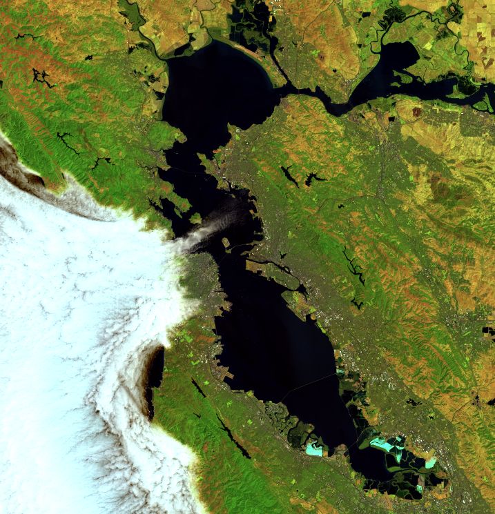
Our microclimate in San Francisco Bay Area is sensitive to the Pacific fog. You know they say the fog enters through the Golden Bay Bridge and goes right to North Berkeley? Occasionally satellite images capture this precise moment. #Landsat
November 19, 2024 at 5:59 AM
Our microclimate in San Francisco Bay Area is sensitive to the Pacific fog. You know they say the fog enters through the Golden Bay Bridge and goes right to North Berkeley? Occasionally satellite images capture this precise moment. #Landsat
Today I got to present with the team at #Snowflake about using their platform with #QGIS and data from #Wherobots. Here is how I did it!
November 19, 2024 at 10:58 PM
Today I got to present with the team at #Snowflake about using their platform with #QGIS and data from #Wherobots. Here is how I did it!
