


Francisco Cañero
@fcanero.bsky.social
PhD student doing research on remote sensing/earth observation, soil mapping and machine learning in Universidad de Sevilla. #remotesensing #hyperspectral #soilscience
Pues dígame usted cómo. Porque fuera de las grandes ciudades, el transporte público es deficiente, por no decir inexistente.

Pere Navarro, director de la DGT: “Al centro no vas en coche eléctrico ni en diesel, vas a ir con transporte público”

Pere Navarro, director de la DGT: "Al centro no vas en coche eléctrico ni en diesel, vas a ir con transporte público"
"En estos momentos si tú paras por una avería, un incidente tal igual y no la colocas, te van a denunciar porque es obligatorio según la ley" ha afirmad Navarro en referencia a las balizas V-16, aunqu...
www.eldiario.es
January 14, 2026 at 2:54 PM
Pues dígame usted cómo. Porque fuera de las grandes ciudades, el transporte público es deficiente, por no decir inexistente.
Reposted by Francisco Cañero

🌊🌡️ La temperatura superficial del Mediterráneo ha estado por encima del promedio normal del período 1991-2020 durante los años 2024 y 2025 completos.
Solo se acercó a los valores normales puntualmente a finales de julio y comienzos de agosto y a mediados de octubre.
[1/2]
Solo se acercó a los valores normales puntualmente a finales de julio y comienzos de agosto y a mediados de octubre.
[1/2]

January 11, 2026 at 11:04 AM
🌊🌡️ La temperatura superficial del Mediterráneo ha estado por encima del promedio normal del período 1991-2020 durante los años 2024 y 2025 completos.
Solo se acercó a los valores normales puntualmente a finales de julio y comienzos de agosto y a mediados de octubre.
[1/2]
Solo se acercó a los valores normales puntualmente a finales de julio y comienzos de agosto y a mediados de octubre.
[1/2]
Según este mapa, ni antes ni ahora existían condiciones para el cultivo de viñedos en regiones andaluzas con gran historia vitivinícola como Montilla, el condado onubense o el noroeste gaditano. No sé si fiarme mucho de la metodología...
Many of the European regions that are suitable for wine-growing in 2025 weren't so in 1960. Rising temperatures will continue to shift these growing regions.

January 10, 2026 at 4:51 PM
Según este mapa, ni antes ni ahora existían condiciones para el cultivo de viñedos en regiones andaluzas con gran historia vitivinícola como Montilla, el condado onubense o el noroeste gaditano. No sé si fiarme mucho de la metodología...
The second first-author paper from my PhD thesis and a collaboration with @gfz.bsky.social, “Evaluating Airborne Hyperspectral Scanner (AHS) for the mapping of soil organic matter and clay in a Mediterranean forest ecosystem” has been published in Catena!
March 10, 2025 at 11:15 AM
The second first-author paper from my PhD thesis and a collaboration with @gfz.bsky.social, “Evaluating Airborne Hyperspectral Scanner (AHS) for the mapping of soil organic matter and clay in a Mediterranean forest ecosystem” has been published in Catena!
Reposted by Francisco Cañero

Thrilled to announce that I have STILL not finished my thesis.
November 28, 2024 at 11:37 AM
Thrilled to announce that I have STILL not finished my thesis.
Reposted by Francisco Cañero
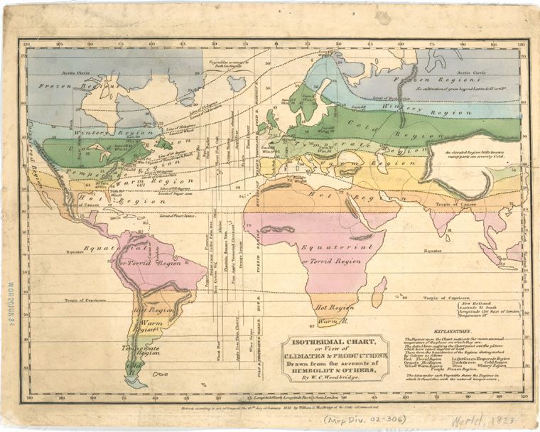
This map was created in 1823 by Alexander von Humboldt - one of my favorite historical figures. It's the first isothermal map. Imagine creating isothermes! How cool is that! Source: buff.ly/3jfAAvG
November 19, 2024 at 8:38 PM
This map was created in 1823 by Alexander von Humboldt - one of my favorite historical figures. It's the first isothermal map. Imagine creating isothermes! How cool is that! Source: buff.ly/3jfAAvG