


Jeroen Bos
@emhistorian.bsky.social
curator | lecturer | historian
works at Vrije Universiteit Amsterdam and University of Groningen
~ follow my travels in cartography and book history ~
works at Vrije Universiteit Amsterdam and University of Groningen
~ follow my travels in cartography and book history ~
(2/2) De reactie van leerlingen én ouders als ik de wereldkaart van de Chinese kaartenmaker Hao Xiaoguang uit 2013 toon (hier te zien: edu.nl/phdbv), blijft mooi.
Dank Grunn, er gaat niets boven je.
Dank Grunn, er gaat niets boven je.
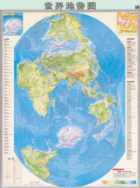
27. Shi jie di shi tu | Design Museum Den Bosch
Bipolaire Chinese wereldkaart Deze verticale wereldkaart zet Europa neer als aanhangsel van Azië. Noord-Amerika staat op zijn kop en is afgesneden van ZuidAmerika, en Afrika ligt excentrisch. Hier sta...
edu.nl
April 12, 2025 at 7:12 PM
(2/2) De reactie van leerlingen én ouders als ik de wereldkaart van de Chinese kaartenmaker Hao Xiaoguang uit 2013 toon (hier te zien: edu.nl/phdbv), blijft mooi.
Dank Grunn, er gaat niets boven je.
Dank Grunn, er gaat niets boven je.
Van het “Guineesch jufferbokje” en de — weinig charmant — opgezette “slingeraap” uit Suriname tot de kaarten van kapitein James Cook. Met alle koloniale complexiteit die aan deze voorwerpen kleeft.
Het tonen spreekt enorm tot de verbeelding. Daar kan geen kennisclip of PowerPoint tegenop!
Het tonen spreekt enorm tot de verbeelding. Daar kan geen kennisclip of PowerPoint tegenop!
March 19, 2025 at 4:41 PM
Van het “Guineesch jufferbokje” en de — weinig charmant — opgezette “slingeraap” uit Suriname tot de kaarten van kapitein James Cook. Met alle koloniale complexiteit die aan deze voorwerpen kleeft.
Het tonen spreekt enorm tot de verbeelding. Daar kan geen kennisclip of PowerPoint tegenop!
Het tonen spreekt enorm tot de verbeelding. Daar kan geen kennisclip of PowerPoint tegenop!
The relationship between #church and #cartography in early modern times is not as far fetched as it may sound. In fact churches were used as reference points for triangulation purposes. Surveyors and #mapmakers climbed church towers to get a good overview of cities and surroundings.
March 10, 2025 at 5:23 PM
The relationship between #church and #cartography in early modern times is not as far fetched as it may sound. In fact churches were used as reference points for triangulation purposes. Surveyors and #mapmakers climbed church towers to get a good overview of cities and surroundings.
Questioning whether the drawn aeroplane on the envelope represents reality the friendly staff of Museum #Aviodrome answered me that indeed it does. The picture (2) they sent me confirms that it is a #Fokker C.II plane and this was the method to take aerial photos in the 1920s and 1930s. Amazing!
March 3, 2025 at 10:11 PM
Questioning whether the drawn aeroplane on the envelope represents reality the friendly staff of Museum #Aviodrome answered me that indeed it does. The picture (2) they sent me confirms that it is a #Fokker C.II plane and this was the method to take aerial photos in the 1920s and 1930s. Amazing!