


Dr. Jeff Masters
@drjeffmasters.bsky.social
Extreme weather and climate change expert writing for Yale Climate Connections. Co-founder, Weather Underground; former hurricane hunter.
Fung-wong the 4th major landfalling typhoon of 2025:
Danas (Cat 3, Taiwan)
Ragasa (Cat 5, Panuitan Island, Philippines)
Kalmaegi (Cat 3, Vietnam)
Fung-wong (Cat 3, Philippines)
No long-term trend since 1946, but the 2004-2025 period has seen a lot (4.2/y) vs. the previous 22-year period (2.6/y).
Danas (Cat 3, Taiwan)
Ragasa (Cat 5, Panuitan Island, Philippines)
Kalmaegi (Cat 3, Vietnam)
Fung-wong (Cat 3, Philippines)
No long-term trend since 1946, but the 2004-2025 period has seen a lot (4.2/y) vs. the previous 22-year period (2.6/y).

November 10, 2025 at 4:30 PM
Fung-wong the 4th major landfalling typhoon of 2025:
Danas (Cat 3, Taiwan)
Ragasa (Cat 5, Panuitan Island, Philippines)
Kalmaegi (Cat 3, Vietnam)
Fung-wong (Cat 3, Philippines)
No long-term trend since 1946, but the 2004-2025 period has seen a lot (4.2/y) vs. the previous 22-year period (2.6/y).
Danas (Cat 3, Taiwan)
Ragasa (Cat 5, Panuitan Island, Philippines)
Kalmaegi (Cat 3, Vietnam)
Fung-wong (Cat 3, Philippines)
No long-term trend since 1946, but the 2004-2025 period has seen a lot (4.2/y) vs. the previous 22-year period (2.6/y).
From the Aon October 31, 2025 Review of Global Catastrophe Activity comes this rainfall image for Melissa:

October 31, 2025 at 4:15 PM
From the Aon October 31, 2025 Review of Global Catastrophe Activity comes this rainfall image for Melissa:
Peak 5-day rainfall in the Dominican Republic from #Melissa was 17.59” (446.5 mm). The capital of Santo Domingo got around 6” (150 mm).
wp.indomet.gob.do/wp-content/u...
wp.indomet.gob.do/wp-content/u...

October 30, 2025 at 8:42 PM
Peak 5-day rainfall in the Dominican Republic from #Melissa was 17.59” (446.5 mm). The capital of Santo Domingo got around 6” (150 mm).
wp.indomet.gob.do/wp-content/u...
wp.indomet.gob.do/wp-content/u...
Nighttime polar orbiter satellite photos of Jamaica before and after #Melissa show how the power grid was affected. Melissa knocked out power to about 77% of Jamaica’s customers, said Minister of Local Government Desmond McKenzie. Photos from worldview.earthdata.nasa.gov

October 30, 2025 at 2:16 PM
Nighttime polar orbiter satellite photos of Jamaica before and after #Melissa show how the power grid was affected. Melissa knocked out power to about 77% of Jamaica’s customers, said Minister of Local Government Desmond McKenzie. Photos from worldview.earthdata.nasa.gov
I've had to update the plot of the strongest tropical cyclones by ocean basin all too often in recent years, since climate change increases the number of high-end storms. Melissa has joined the club, tied with Dorian (2019) as strongest Atlantic hurricane recorded outside the Gulf of Mexico.

October 28, 2025 at 10:16 PM
I've had to update the plot of the strongest tropical cyclones by ocean basin all too often in recent years, since climate change increases the number of high-end storms. Melissa has joined the club, tied with Dorian (2019) as strongest Atlantic hurricane recorded outside the Gulf of Mexico.
The western end of Jamaica where #Melissa is projected to make landfall has the least well-built structures of anyplace on the island. Graphic is from a 2021 paper, "Poverty and hurricane risk exposure in Jamaica": www.researchgate.net/publication/...

October 28, 2025 at 1:53 AM
The western end of Jamaica where #Melissa is projected to make landfall has the least well-built structures of anyplace on the island. Graphic is from a 2021 paper, "Poverty and hurricane risk exposure in Jamaica": www.researchgate.net/publication/...
Category 5 storms have been increasing globally beginning in 1982, when satellite data accurate enough to identify these great storms first became available. Ratings are from NHC and the Joint Typhoon Warning Center. Five Cat 5s so far this year, which is near the average of 5.3 Cat 5s/year.

October 27, 2025 at 6:09 PM
Category 5 storms have been increasing globally beginning in 1982, when satellite data accurate enough to identify these great storms first became available. Ratings are from NHC and the Joint Typhoon Warning Center. Five Cat 5s so far this year, which is near the average of 5.3 Cat 5s/year.
Jamaica has low storm surge risk—not a lot of low-lying areas. An exception: Kingston’s Norman Manley International Airport (built on fill), Soapberry Wastewater Treatment Plant, Portmore Mall, Jamworld Entertainment Center, the National Gallery, Petrojam Refinery, Caribbean Maritime University.

October 24, 2025 at 5:06 PM
Jamaica has low storm surge risk—not a lot of low-lying areas. An exception: Kingston’s Norman Manley International Airport (built on fill), Soapberry Wastewater Treatment Plant, Portmore Mall, Jamworld Entertainment Center, the National Gallery, Petrojam Refinery, Caribbean Maritime University.
Late Oct. 2012, Hurricane Sandy hit Jamaica (Cat 1), Cuba (Cat 3), interacted with an extratropical storm, which slung Cat 1 Sandy into NJ. Some ensemble forecasts are predicting a similar scenario for #Melissa. Low probability, but an East Coast extratropical storm is forecast for late next week.

October 24, 2025 at 2:00 AM
Late Oct. 2012, Hurricane Sandy hit Jamaica (Cat 1), Cuba (Cat 3), interacted with an extratropical storm, which slung Cat 1 Sandy into NJ. Some ensemble forecasts are predicting a similar scenario for #Melissa. Low probability, but an East Coast extratropical storm is forecast for late next week.
Jamaica has low storm surge risk—not a lot of low-lying areas. An exception: Kingston’s Norman Manley International Airport (built on fill), Soapberry Wastewater Treatment Plant, Portmore Mall, Jamworld Entertainment Center, the National Gallery, Petrojam Refinery, Caribbean Maritime University.

October 24, 2025 at 12:36 AM
Jamaica has low storm surge risk—not a lot of low-lying areas. An exception: Kingston’s Norman Manley International Airport (built on fill), Soapberry Wastewater Treatment Plant, Portmore Mall, Jamworld Entertainment Center, the National Gallery, Petrojam Refinery, Caribbean Maritime University.
At the No Kings protest in Farmington, MI today. I’ve been signing multiple petitions; good to see democracy being valued!

October 18, 2025 at 5:31 PM
At the No Kings protest in Farmington, MI today. I’ve been signing multiple petitions; good to see democracy being valued!
When will the climate change coastal property bubble pop? A significant acceleration in coastal flooding from a lunar orbit shift (mid-2030s) will significantly stress the market. My 2024 post: "When will climate change turn life in the U.S. upside down?"
yaleclimateconnections.org/2024/08/when...
yaleclimateconnections.org/2024/08/when...

October 9, 2025 at 1:26 PM
When will the climate change coastal property bubble pop? A significant acceleration in coastal flooding from a lunar orbit shift (mid-2030s) will significantly stress the market. My 2024 post: "When will climate change turn life in the U.S. upside down?"
yaleclimateconnections.org/2024/08/when...
yaleclimateconnections.org/2024/08/when...
Latest seasonal forecast from NOAA is not looking promising for the Colorado River watershed: a hot and dry start to winter is predicted.

October 9, 2025 at 1:00 AM
Latest seasonal forecast from NOAA is not looking promising for the Colorado River watershed: a hot and dry start to winter is predicted.
Just visited Antelope Canyon, AZ. The colors and rock shapes were exquisite! Foreign tourism is going well in AZ; I was the only American in my group of 16. Lots of Germans and Japanese here, and at the Grand Canyon.

September 27, 2025 at 5:16 PM
Just visited Antelope Canyon, AZ. The colors and rock shapes were exquisite! Foreign tourism is going well in AZ; I was the only American in my group of 16. Lots of Germans and Japanese here, and at the Grand Canyon.
Great sunset at Yavapai Point, Grand Canyon tonight.

September 26, 2025 at 2:12 AM
Great sunset at Yavapai Point, Grand Canyon tonight.
Visited the ASU Art Museum in Tempe today; they have a powerful piece by American artist Michelangelo Lovelace called “Katrina Aftermath”.

September 20, 2025 at 9:07 PM
Visited the ASU Art Museum in Tempe today; they have a powerful piece by American artist Michelangelo Lovelace called “Katrina Aftermath”.
In his excellent 2020 book, "Katrina: a history, 1915-2015", Andy Horowitz, Associate Professor of History at the University of Connecticut, has this amazing image scanned from the 1938 book, "South Louisiana and the beautiful Gulf Coast".

August 27, 2025 at 11:53 PM
In his excellent 2020 book, "Katrina: a history, 1915-2015", Andy Horowitz, Associate Professor of History at the University of Connecticut, has this amazing image scanned from the 1938 book, "South Louisiana and the beautiful Gulf Coast".
The tide gauge at Duck NC, in the northern Outer Banks, is predicted to experience major flooding from Hurricane #Erin during the Thursday evening high tide. This would be the fifth-highest water level since records began in 1999, 0.82' below the record set during Cat 2 Hurricane Isabel of 2003.

August 19, 2025 at 4:28 PM
The tide gauge at Duck NC, in the northern Outer Banks, is predicted to experience major flooding from Hurricane #Erin during the Thursday evening high tide. This would be the fifth-highest water level since records began in 1999, 0.82' below the record set during Cat 2 Hurricane Isabel of 2003.
Verification of official NHC hurricane intensity forecasts for hurricanes that rapidly intensified in the Atlantic, 2010–2024. RI forecasts have shown improvement over the past 15 years, but still tend to be biased to low. (Image credit: 2024 National Hurricane Center Forecast Verification Report)

August 16, 2025 at 11:38 PM
Verification of official NHC hurricane intensity forecasts for hurricanes that rapidly intensified in the Atlantic, 2010–2024. RI forecasts have shown improvement over the past 15 years, but still tend to be biased to low. (Image credit: 2024 National Hurricane Center Forecast Verification Report)
Saw the first pyrocumulus cloud of my life last night, over Washington’s Olympic Peninsula, from Botany Bay on Vancouver Island. Our plans to camp at Cowichan Lake yesterday got aborted because a big wildfire erupted northwest of us, bringing an AQI spike of 250. Life in the Pyrocene!

August 13, 2025 at 4:31 PM
Saw the first pyrocumulus cloud of my life last night, over Washington’s Olympic Peninsula, from Botany Bay on Vancouver Island. Our plans to camp at Cowichan Lake yesterday got aborted because a big wildfire erupted northwest of us, bringing an AQI spike of 250. Life in the Pyrocene!
Prior to 2020's Hurricane Paulette, I never saw a satellite image of an Atlantic named storm accompanied by wildfire smoke. Now, we see one most years. Last year, it was Ernesto. 2025's offering: Tropical Storm Dexter.

August 5, 2025 at 7:40 PM
Prior to 2020's Hurricane Paulette, I never saw a satellite image of an Atlantic named storm accompanied by wildfire smoke. Now, we see one most years. Last year, it was Ernesto. 2025's offering: Tropical Storm Dexter.
The wildfire smoke episode affecting the U.S. is set to invade new territory later this week, with AQIs in the 100-160 range (USG to Unhealthy) predicted from the Midwest southwards into the Carolinas, Georgia, and Alabama. Forecast for 8 am EDT Friday from NASA: fluid.nccs.nasa.gov/wxmaps/chem2...

August 5, 2025 at 5:14 PM
The wildfire smoke episode affecting the U.S. is set to invade new territory later this week, with AQIs in the 100-160 range (USG to Unhealthy) predicted from the Midwest southwards into the Carolinas, Georgia, and Alabama. Forecast for 8 am EDT Friday from NASA: fluid.nccs.nasa.gov/wxmaps/chem2...
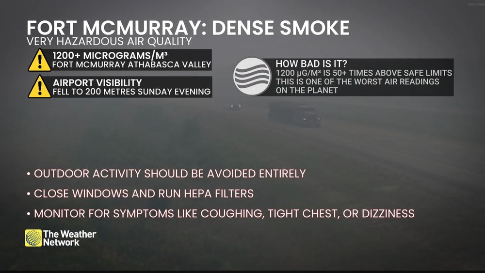
“Visibility hovered around or below 1 km in Fort McMurray, Alberta for most of the day Sunday, with the airport reporting exceptionally low visibility of just 200 metres at 5:00 p.m. local time.” The AQI hit 2242: 10x higher than the “hazardous” level. www.theweathernetwork.com/en/news/weat...
August 4, 2025 at 2:14 AM
“Visibility hovered around or below 1 km in Fort McMurray, Alberta for most of the day Sunday, with the airport reporting exceptionally low visibility of just 200 metres at 5:00 p.m. local time.” The AQI hit 2242: 10x higher than the “hazardous” level. www.theweathernetwork.com/en/news/weat...
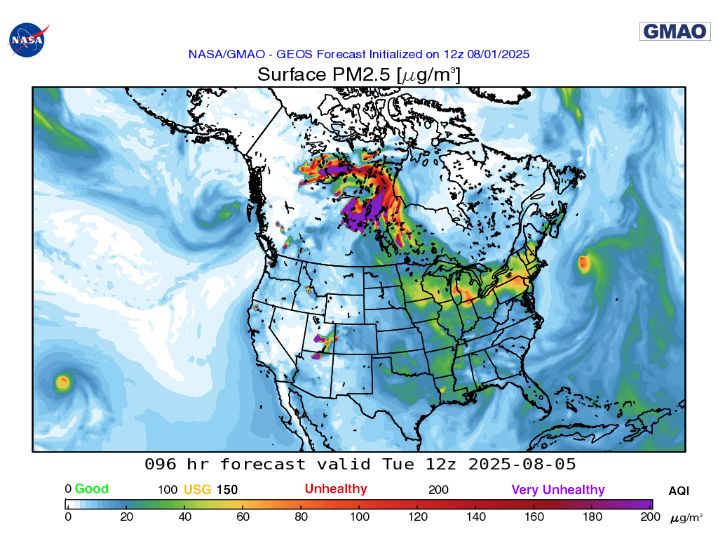
PM 2.5 forecast for 8 am EDT Tuesday from NASA's model (fluid.nccs.nasa.gov/wxmaps/chem2...) calling for AQIs in the orange "Unhealthy for Sensitive Groups" to red "Unhealthy" range for most of the Midwest and Northeast. See: yaleclimateconnections.org/2025/07/15-s... for sources of smoke forecasts.
August 2, 2025 at 12:25 AM
PM 2.5 forecast for 8 am EDT Tuesday from NASA's model (fluid.nccs.nasa.gov/wxmaps/chem2...) calling for AQIs in the orange "Unhealthy for Sensitive Groups" to red "Unhealthy" range for most of the Midwest and Northeast. See: yaleclimateconnections.org/2025/07/15-s... for sources of smoke forecasts.
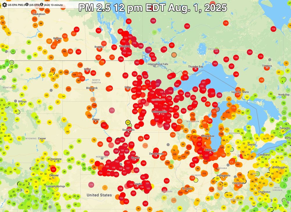
Wildfire smoke from Canada is bringing AQIs for PM 2.5 into the red "Unhealthy" range unusually far south today. See my post, "15 sources of wildfire smoke forecasts for North America" (yaleclimateconnections.org/2025/07/15-s...) to see ways to get forecasts on where the smoke is going.
August 1, 2025 at 4:30 PM
Wildfire smoke from Canada is bringing AQIs for PM 2.5 into the red "Unhealthy" range unusually far south today. See my post, "15 sources of wildfire smoke forecasts for North America" (yaleclimateconnections.org/2025/07/15-s...) to see ways to get forecasts on where the smoke is going.