


Daniel Machacek
@danielmachacek.bsky.social
Space nerd, Image processor,
Lazy photographer,
Humanist
Lazy photographer,
Humanist
As far as the weather forecast goes, it looks like I only had one hour to try to get a pictures of interstellar comet 3I/Atlas.
And it worked!
Even the tail is faintly visible.
It looks like typical comet even with small equipment - Olympus E-M1II with 75-300 mm lens and Minitrack LX2 tracker.
And it worked!
Even the tail is faintly visible.
It looks like typical comet even with small equipment - Olympus E-M1II with 75-300 mm lens and Minitrack LX2 tracker.

November 20, 2025 at 11:27 PM
As far as the weather forecast goes, it looks like I only had one hour to try to get a pictures of interstellar comet 3I/Atlas.
And it worked!
Even the tail is faintly visible.
It looks like typical comet even with small equipment - Olympus E-M1II with 75-300 mm lens and Minitrack LX2 tracker.
And it worked!
Even the tail is faintly visible.
It looks like typical comet even with small equipment - Olympus E-M1II with 75-300 mm lens and Minitrack LX2 tracker.
Bright auroras visible on the night side of Jupiter from the Juno's SRU camera during orbits 69 and 70.
Left image:
Date: 2025/01/28.
Time: 23:08:17 (UTC).
Right image:
Date: 2025/03/02.
Time: 16:04:45 (UTC).
Credit: NASA/Caltech-JPL/SwRI/D. Machacek.
Left image:
Date: 2025/01/28.
Time: 23:08:17 (UTC).
Right image:
Date: 2025/03/02.
Time: 16:04:45 (UTC).
Credit: NASA/Caltech-JPL/SwRI/D. Machacek.


October 21, 2025 at 10:26 AM
Bright auroras visible on the night side of Jupiter from the Juno's SRU camera during orbits 69 and 70.
Left image:
Date: 2025/01/28.
Time: 23:08:17 (UTC).
Right image:
Date: 2025/03/02.
Time: 16:04:45 (UTC).
Credit: NASA/Caltech-JPL/SwRI/D. Machacek.
Left image:
Date: 2025/01/28.
Time: 23:08:17 (UTC).
Right image:
Date: 2025/03/02.
Time: 16:04:45 (UTC).
Credit: NASA/Caltech-JPL/SwRI/D. Machacek.
Major part of this map is based on monochrome and filtered maps published by New Horizons team (links in the description in the map), but I have expanded coverage by using additional data not used in these maps. These are data for areas hidden in twilight and edge areas photographed by LORRI imager.


October 1, 2025 at 3:43 AM
Major part of this map is based on monochrome and filtered maps published by New Horizons team (links in the description in the map), but I have expanded coverage by using additional data not used in these maps. These are data for areas hidden in twilight and edge areas photographed by LORRI imager.
My new color photographic map of Pluto is now online.
Full resolution image version (~322Mpix) is available on Flickr www.flickr.com/photos/10958...
PDF version (~73MB) is available here: drive.google.com/file/d/1EW-x...
🧵 1/5
Full resolution image version (~322Mpix) is available on Flickr www.flickr.com/photos/10958...
PDF version (~73MB) is available here: drive.google.com/file/d/1EW-x...
🧵 1/5

October 1, 2025 at 3:43 AM
My new color photographic map of Pluto is now online.
Full resolution image version (~322Mpix) is available on Flickr www.flickr.com/photos/10958...
PDF version (~73MB) is available here: drive.google.com/file/d/1EW-x...
🧵 1/5
Full resolution image version (~322Mpix) is available on Flickr www.flickr.com/photos/10958...
PDF version (~73MB) is available here: drive.google.com/file/d/1EW-x...
🧵 1/5
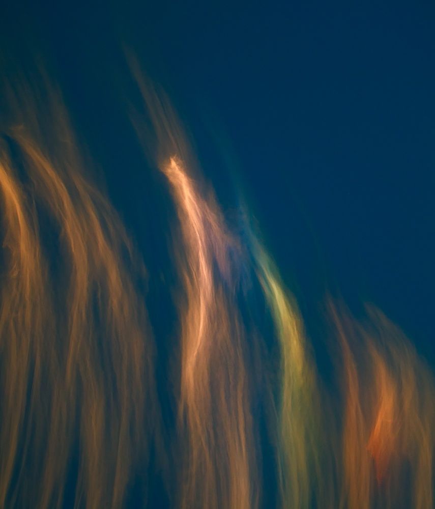
Iridescent clouds at NATO Days 2025 show together with the British Red Arrows aerobatic display team, German Eurofighter Typhoon and Slovak F-16.


September 23, 2025 at 10:05 PM
Iridescent clouds at NATO Days 2025 show together with the British Red Arrows aerobatic display team, German Eurofighter Typhoon and Slovak F-16.
A few selected images of Mars processed from a new batch of data from the EXI camera aboard the Hope probe.
The dates and times of the images and some details are in the ALT text.
The dates and times of the images and some details are in the ALT text.


September 14, 2025 at 3:01 AM
A few selected images of Mars processed from a new batch of data from the EXI camera aboard the Hope probe.
The dates and times of the images and some details are in the ALT text.
The dates and times of the images and some details are in the ALT text.
A teaser for the Pluto map I'm working on, originally scheduled to be released on the 10th anniversary of the New Horizons flyby of Pluto.
These are minimaps which supplement the main map and contain less information - the main map is much larger and contains all the official and unofficial names.
These are minimaps which supplement the main map and contain less information - the main map is much larger and contains all the official and unofficial names.


August 27, 2025 at 10:42 PM
A teaser for the Pluto map I'm working on, originally scheduled to be released on the 10th anniversary of the New Horizons flyby of Pluto.
These are minimaps which supplement the main map and contain less information - the main map is much larger and contains all the official and unofficial names.
These are minimaps which supplement the main map and contain less information - the main map is much larger and contains all the official and unofficial names.
Something happened in space a few minutes ago.
It looks like illuminated fuel from a rocket's second stage.
I took these photos from Silesia in the Czech Republic.
It looks like illuminated fuel from a rocket's second stage.
I took these photos from Silesia in the Czech Republic.


August 25, 2025 at 9:14 PM
Something happened in space a few minutes ago.
It looks like illuminated fuel from a rocket's second stage.
I took these photos from Silesia in the Czech Republic.
It looks like illuminated fuel from a rocket's second stage.
I took these photos from Silesia in the Czech Republic.
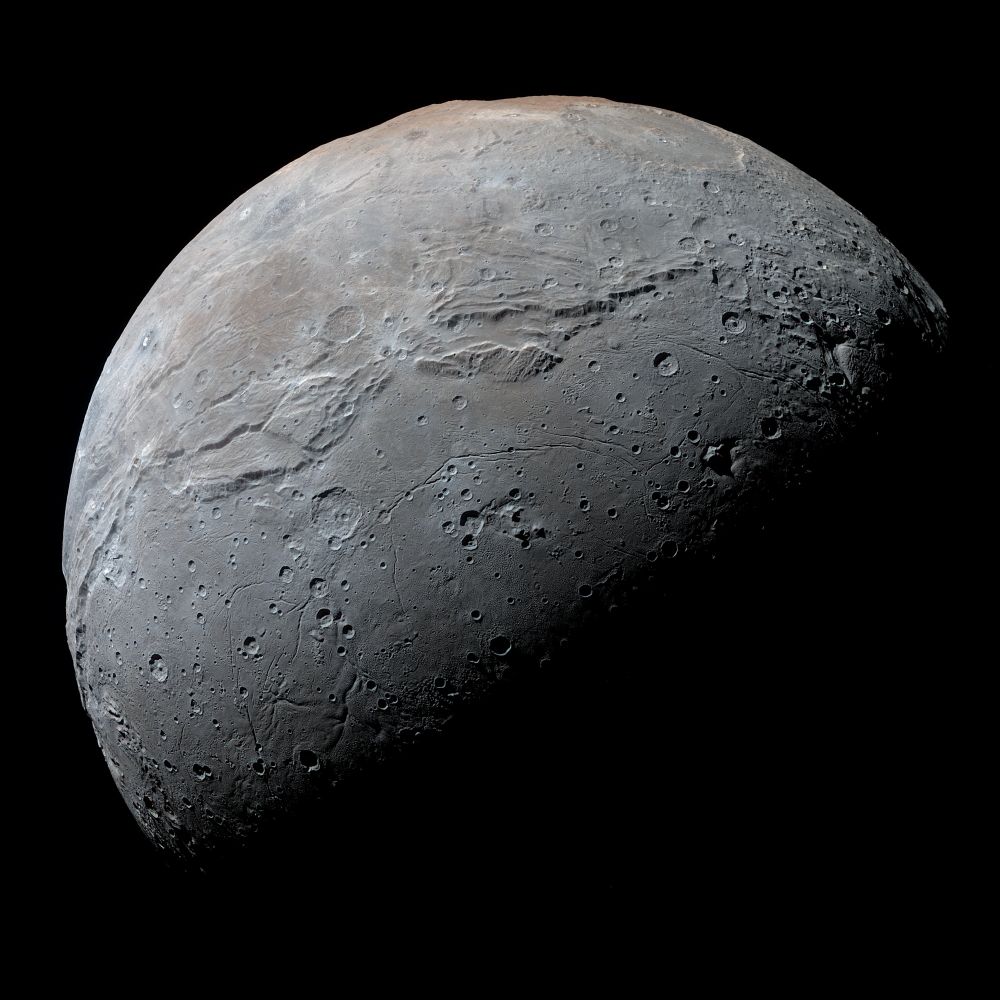
Ten years (and one day) ago New Horizons 🛰 made first and probably for looong time the last flyby of Pluto-Charon system.
This is best (half)global image of Charon obtained by MVIC camera. It combines hi-res B/W image with color images at lower resolution.
Credits: NASA/JHUAPL/SwRI/D. Macháček.
This is best (half)global image of Charon obtained by MVIC camera. It combines hi-res B/W image with color images at lower resolution.
Credits: NASA/JHUAPL/SwRI/D. Macháček.
July 15, 2025 at 10:16 AM
Ten years (and one day) ago New Horizons 🛰 made first and probably for looong time the last flyby of Pluto-Charon system.
This is best (half)global image of Charon obtained by MVIC camera. It combines hi-res B/W image with color images at lower resolution.
Credits: NASA/JHUAPL/SwRI/D. Macháček.
This is best (half)global image of Charon obtained by MVIC camera. It combines hi-res B/W image with color images at lower resolution.
Credits: NASA/JHUAPL/SwRI/D. Macháček.
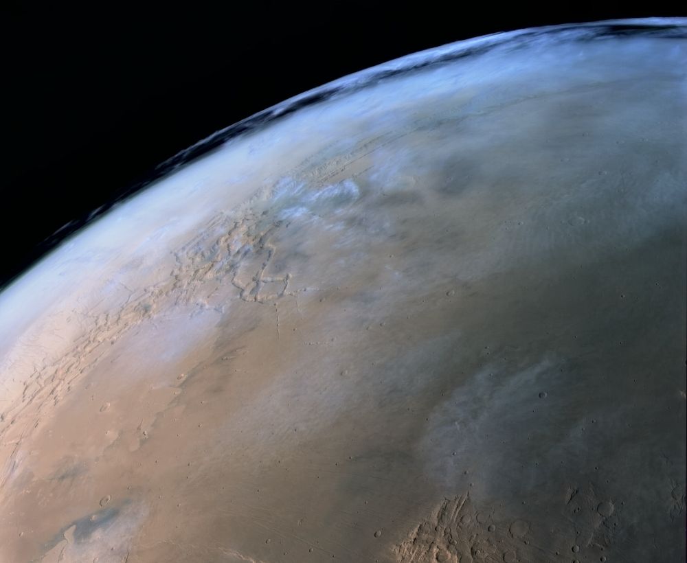
High altitude clouds over the Martian canyon Valles Marineris.
This is a small crop from the HQ516 image sequence taken by the HRSC camera aboard ESA's Mars Express spacecraft on January 3, 2025.
Credit: ESA/DLR/FU Berlin (G. Neukum)/D. Machacek.
This is a small crop from the HQ516 image sequence taken by the HRSC camera aboard ESA's Mars Express spacecraft on January 3, 2025.
Credit: ESA/DLR/FU Berlin (G. Neukum)/D. Machacek.
July 11, 2025 at 9:34 PM
High altitude clouds over the Martian canyon Valles Marineris.
This is a small crop from the HQ516 image sequence taken by the HRSC camera aboard ESA's Mars Express spacecraft on January 3, 2025.
Credit: ESA/DLR/FU Berlin (G. Neukum)/D. Machacek.
This is a small crop from the HQ516 image sequence taken by the HRSC camera aboard ESA's Mars Express spacecraft on January 3, 2025.
Credit: ESA/DLR/FU Berlin (G. Neukum)/D. Machacek.
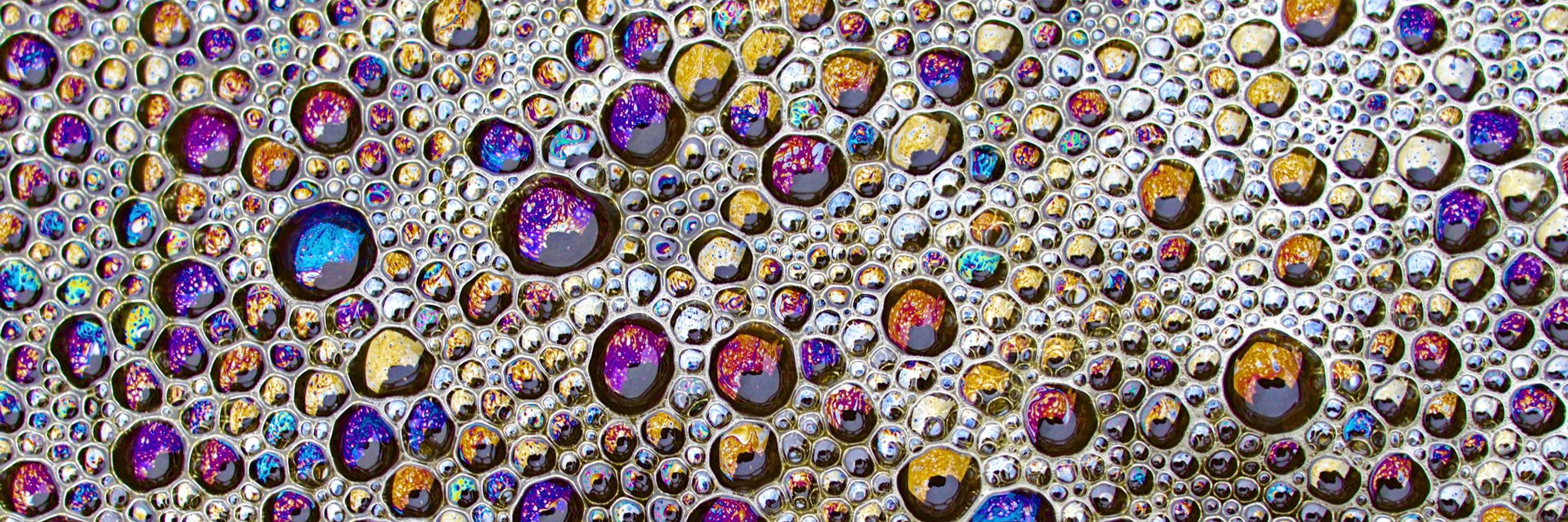
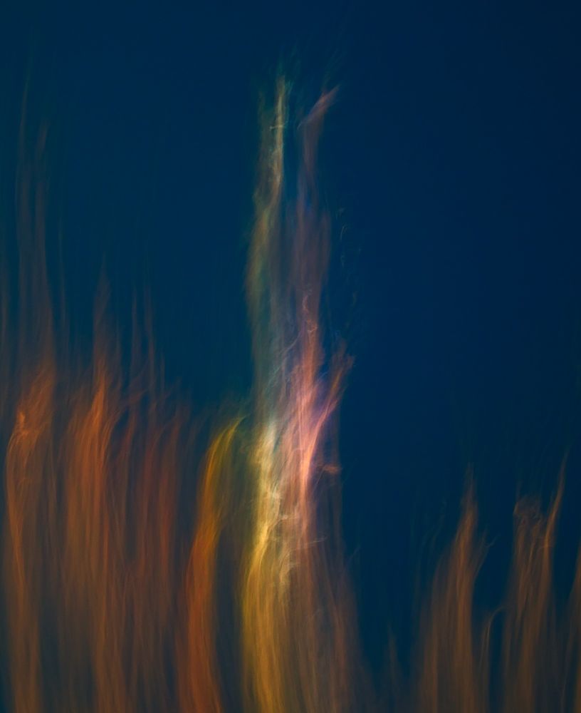
Small details of today's cirrus clouds.
Images have been enhanced to better show different colors.
Most colorful areas are part of circumzenithal arc - halo effect caused by refraction of sunlight through ice crystals and some colors are probably also part of irisation caused by diffraction.
Images have been enhanced to better show different colors.
Most colorful areas are part of circumzenithal arc - halo effect caused by refraction of sunlight through ice crystals and some colors are probably also part of irisation caused by diffraction.
May 11, 2025 at 11:59 PM
Small details of today's cirrus clouds.
Images have been enhanced to better show different colors.
Most colorful areas are part of circumzenithal arc - halo effect caused by refraction of sunlight through ice crystals and some colors are probably also part of irisation caused by diffraction.
Images have been enhanced to better show different colors.
Most colorful areas are part of circumzenithal arc - halo effect caused by refraction of sunlight through ice crystals and some colors are probably also part of irisation caused by diffraction.
Images of Mars processed from newly released data from EXI imager onboard Hope probe.
Downscaled (3×) montage of selected images taken between 24 and 29 August 2024 and full-res image, taken on 26 August at 6:50 UTC, showing south polar ice cap, Argyre Planitia and Valles Marineris (south is up).
Downscaled (3×) montage of selected images taken between 24 and 29 August 2024 and full-res image, taken on 26 August at 6:50 UTC, showing south polar ice cap, Argyre Planitia and Valles Marineris (south is up).


April 29, 2025 at 5:40 PM
Images of Mars processed from newly released data from EXI imager onboard Hope probe.
Downscaled (3×) montage of selected images taken between 24 and 29 August 2024 and full-res image, taken on 26 August at 6:50 UTC, showing south polar ice cap, Argyre Planitia and Valles Marineris (south is up).
Downscaled (3×) montage of selected images taken between 24 and 29 August 2024 and full-res image, taken on 26 August at 6:50 UTC, showing south polar ice cap, Argyre Planitia and Valles Marineris (south is up).
3D anaglyph image of asteroid Donaldjohanson.
Anaglyph is made from images taken by Long-Range Reconnaissance Imager (L’LORRI) on board spacecraft Lucy on April 20, 2025.
Original images and more info about Lucy's flyby of Donaldjohanson here:
science.nasa.gov/image-articl...
Anaglyph is made from images taken by Long-Range Reconnaissance Imager (L’LORRI) on board spacecraft Lucy on April 20, 2025.
Original images and more info about Lucy's flyby of Donaldjohanson here:
science.nasa.gov/image-articl...

April 21, 2025 at 7:00 PM
3D anaglyph image of asteroid Donaldjohanson.
Anaglyph is made from images taken by Long-Range Reconnaissance Imager (L’LORRI) on board spacecraft Lucy on April 20, 2025.
Original images and more info about Lucy's flyby of Donaldjohanson here:
science.nasa.gov/image-articl...
Anaglyph is made from images taken by Long-Range Reconnaissance Imager (L’LORRI) on board spacecraft Lucy on April 20, 2025.
Original images and more info about Lucy's flyby of Donaldjohanson here:
science.nasa.gov/image-articl...
Bright aurora visible on the night side of Jupiter from the Juno's SRU camera during the Orbit 63.
Date: 2024/07/16.
Time: 14:27:20 (UTC).
Credit: NASA/Caltech-JPL/SwRI/D. Machacek.
Date: 2024/07/16.
Time: 14:27:20 (UTC).
Credit: NASA/Caltech-JPL/SwRI/D. Machacek.

April 4, 2025 at 12:56 AM
Bright aurora visible on the night side of Jupiter from the Juno's SRU camera during the Orbit 63.
Date: 2024/07/16.
Time: 14:27:20 (UTC).
Credit: NASA/Caltech-JPL/SwRI/D. Machacek.
Date: 2024/07/16.
Time: 14:27:20 (UTC).
Credit: NASA/Caltech-JPL/SwRI/D. Machacek.
Tonight's rendezvous of Moon and Mars.

February 9, 2025 at 10:00 PM
Tonight's rendezvous of Moon and Mars.

February 2, 2025 at 5:23 PM
"Snowman" on asteroid Vesta from Dawn spacecraft.
This surface feature is located in the equatorial part of Vesta and is is formed by three craters (from the largest to the smallest) - Marcia, Calpurnia and Minucia.
Credit: NASA / JPL / MPS / DLR / IDA / D. Machacek.
This surface feature is located in the equatorial part of Vesta and is is formed by three craters (from the largest to the smallest) - Marcia, Calpurnia and Minucia.
Credit: NASA / JPL / MPS / DLR / IDA / D. Machacek.

February 2, 2025 at 5:20 PM
"Snowman" on asteroid Vesta from Dawn spacecraft.
This surface feature is located in the equatorial part of Vesta and is is formed by three craters (from the largest to the smallest) - Marcia, Calpurnia and Minucia.
Credit: NASA / JPL / MPS / DLR / IDA / D. Machacek.
This surface feature is located in the equatorial part of Vesta and is is formed by three craters (from the largest to the smallest) - Marcia, Calpurnia and Minucia.
Credit: NASA / JPL / MPS / DLR / IDA / D. Machacek.

South pole pentagon of Jupiter in thermal infrared from Juno's JIRAM imaging spectrometer on July 27, 2020 (Orbit 28). Resolution ~40 km/pixel.
Credit:
NASA/JPL-Caltech/SwRI/MSSS/ASI/INAF/JIRAM/D. Machacek.
Credit:
NASA/JPL-Caltech/SwRI/MSSS/ASI/INAF/JIRAM/D. Machacek.

January 22, 2025 at 4:38 PM
South pole pentagon of Jupiter in thermal infrared from Juno's JIRAM imaging spectrometer on July 27, 2020 (Orbit 28). Resolution ~40 km/pixel.
Credit:
NASA/JPL-Caltech/SwRI/MSSS/ASI/INAF/JIRAM/D. Machacek.
Credit:
NASA/JPL-Caltech/SwRI/MSSS/ASI/INAF/JIRAM/D. Machacek.
Direct link to the full mosaic (4,000×6,500 pixels)
live.staticflickr.com/7317/1110098...
live.staticflickr.com/7317/1110098...

January 18, 2025 at 1:29 AM
Direct link to the full mosaic (4,000×6,500 pixels)
live.staticflickr.com/7317/1110098...
live.staticflickr.com/7317/1110098...
Ancient Martian impact basin Argyre Planitia
(with the smiling crater Galle).
This is a reduced crop from larger mosaic (link below) made from images taken by Viking Orbiter 1 on July 24, 1976.
Few images from different angle also allowed 3D anaglyph version.
Credit: NASA/JPL/D. Machacek.
(with the smiling crater Galle).
This is a reduced crop from larger mosaic (link below) made from images taken by Viking Orbiter 1 on July 24, 1976.
Few images from different angle also allowed 3D anaglyph version.
Credit: NASA/JPL/D. Machacek.


January 18, 2025 at 1:29 AM
Ancient Martian impact basin Argyre Planitia
(with the smiling crater Galle).
This is a reduced crop from larger mosaic (link below) made from images taken by Viking Orbiter 1 on July 24, 1976.
Few images from different angle also allowed 3D anaglyph version.
Credit: NASA/JPL/D. Machacek.
(with the smiling crater Galle).
This is a reduced crop from larger mosaic (link below) made from images taken by Viking Orbiter 1 on July 24, 1976.
Few images from different angle also allowed 3D anaglyph version.
Credit: NASA/JPL/D. Machacek.
Processed image from DISR Side Looking Imager after Huygens' landing on Titan.
Contrast is enhanced to make distant details more visible.
Contrast is enhanced to make distant details more visible.

January 15, 2025 at 1:30 AM
Processed image from DISR Side Looking Imager after Huygens' landing on Titan.
Contrast is enhanced to make distant details more visible.
Contrast is enhanced to make distant details more visible.
Mosaics of Titan's surface from DISR imager onboard Huygens probe 20 years ago (2005/01/14).
All of them have 2000×2000 pixels (maximum for Bluesky) and they cover areas 64×64, 16×16, 4×4 and 1×1 km.
Resolution is 32, 8, 2 and 0.5 meters/pixel.
Credit: ESA/NASA/University of Arizona/D. Machacek.
All of them have 2000×2000 pixels (maximum for Bluesky) and they cover areas 64×64, 16×16, 4×4 and 1×1 km.
Resolution is 32, 8, 2 and 0.5 meters/pixel.
Credit: ESA/NASA/University of Arizona/D. Machacek.


January 15, 2025 at 1:30 AM
Mosaics of Titan's surface from DISR imager onboard Huygens probe 20 years ago (2005/01/14).
All of them have 2000×2000 pixels (maximum for Bluesky) and they cover areas 64×64, 16×16, 4×4 and 1×1 km.
Resolution is 32, 8, 2 and 0.5 meters/pixel.
Credit: ESA/NASA/University of Arizona/D. Machacek.
All of them have 2000×2000 pixels (maximum for Bluesky) and they cover areas 64×64, 16×16, 4×4 and 1×1 km.
Resolution is 32, 8, 2 and 0.5 meters/pixel.
Credit: ESA/NASA/University of Arizona/D. Machacek.
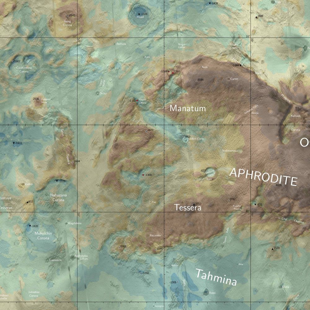
A preview of my re-worked map of Venus.
This 2000×2000 pixel crop at full resolution of the map is centered on Manatum Tessera in the west part of Aphrodite Terra.
This 2000×2000 pixel crop at full resolution of the map is centered on Manatum Tessera in the west part of Aphrodite Terra.
January 12, 2025 at 5:47 PM
A preview of my re-worked map of Venus.
This 2000×2000 pixel crop at full resolution of the map is centered on Manatum Tessera in the west part of Aphrodite Terra.
This 2000×2000 pixel crop at full resolution of the map is centered on Manatum Tessera in the west part of Aphrodite Terra.
A little Venus-Moon rendezvous tonight.

January 3, 2025 at 8:07 PM
A little Venus-Moon rendezvous tonight.