


British Geological Survey
@bgs.ac.uk
A world-leading independent research organisation providing objective, expert geoscientific data, information and knowledge 🌎
(The GIF shows an animation of SOHO LASCO Coronograph imagery showing the coronal mass ejection (CME) associated with the X5 solar flare. The scintillation is due to energetic particles hitting the sensor. Image: NASA/ESA.)
November 12, 2025 at 3:15 PM
(The GIF shows an animation of SOHO LASCO Coronograph imagery showing the coronal mass ejection (CME) associated with the X5 solar flare. The scintillation is due to energetic particles hitting the sensor. Image: NASA/ESA.)
Intense geomagnetic activity could disrupt technology such as communication systems, global positioning systems and satellite orbits.
Learn more:
www.bgs.ac.uk/news/uk-brac...
Learn more:
www.bgs.ac.uk/news/uk-brac...

November 12, 2025 at 2:55 PM
Intense geomagnetic activity could disrupt technology such as communication systems, global positioning systems and satellite orbits.
Learn more:
www.bgs.ac.uk/news/uk-brac...
Learn more:
www.bgs.ac.uk/news/uk-brac...
Geomagnetic storms are caused by solar activity interacting with the Earth’s magnetic field, which has implications for national energy infrastructure and navigation. For this reason, it is listed as one of the primary hazards on the UK’s National Risk Register.
November 12, 2025 at 2:55 PM
Geomagnetic storms are caused by solar activity interacting with the Earth’s magnetic field, which has implications for national energy infrastructure and navigation. For this reason, it is listed as one of the primary hazards on the UK’s National Risk Register.
For more information and to reserve your FREE online place, please visit:
www.eventbrite.co.uk/e/ai-for-nat...
www.eventbrite.co.uk/e/ai-for-nat...

AI for Natural Hazards Workshop
This event aims to bring together industry and research institutions from the UK and Italy to drive collaborations on EO/AI driven solutions
www.eventbrite.co.uk
November 11, 2025 at 12:02 PM
For more information and to reserve your FREE online place, please visit:
www.eventbrite.co.uk/e/ai-for-nat...
www.eventbrite.co.uk/e/ai-for-nat...
Join BGS remote sensing geoscientist, Alessandro Novellino and colleagues for this special one-off workshop which aims to bring together stakeholders from the UK and Italy to drive collaborations around AI-driven solutions and connect interested parties with sources of potential funding.
November 11, 2025 at 12:02 PM
Join BGS remote sensing geoscientist, Alessandro Novellino and colleagues for this special one-off workshop which aims to bring together stakeholders from the UK and Italy to drive collaborations around AI-driven solutions and connect interested parties with sources of potential funding.
We used long-term radon measurements, made in over 560,000 homes across Great Britain and 23,000 homes across Northern Ireland (without affecting householders’ confidentiality), combined with geological map data.
Check to see the maximum radon potential in your area:
www.bgs.ac.uk/datasets/rad...
Check to see the maximum radon potential in your area:
www.bgs.ac.uk/datasets/rad...

Indicative Atlas of Radon - British Geological Survey
Radon is a natural radioactive gas, which enters buildings from the ground. Exposure to high concentrations increases the risk of lung cancer.
www.bgs.ac.uk
November 7, 2025 at 2:35 PM
We used long-term radon measurements, made in over 560,000 homes across Great Britain and 23,000 homes across Northern Ireland (without affecting householders’ confidentiality), combined with geological map data.
Check to see the maximum radon potential in your area:
www.bgs.ac.uk/datasets/rad...
Check to see the maximum radon potential in your area:
www.bgs.ac.uk/datasets/rad...
In collaboration with UKSHA, BGS and the Geological Survey of Northern Ireland (GSNI) offers the indicative atlas for radon in Great Britain and the indicative radon atlas for Northern Ireland to help homeowners and businesses ascertain if their properties are at risk.
November 7, 2025 at 2:23 PM
In collaboration with UKSHA, BGS and the Geological Survey of Northern Ireland (GSNI) offers the indicative atlas for radon in Great Britain and the indicative radon atlas for Northern Ireland to help homeowners and businesses ascertain if their properties are at risk.
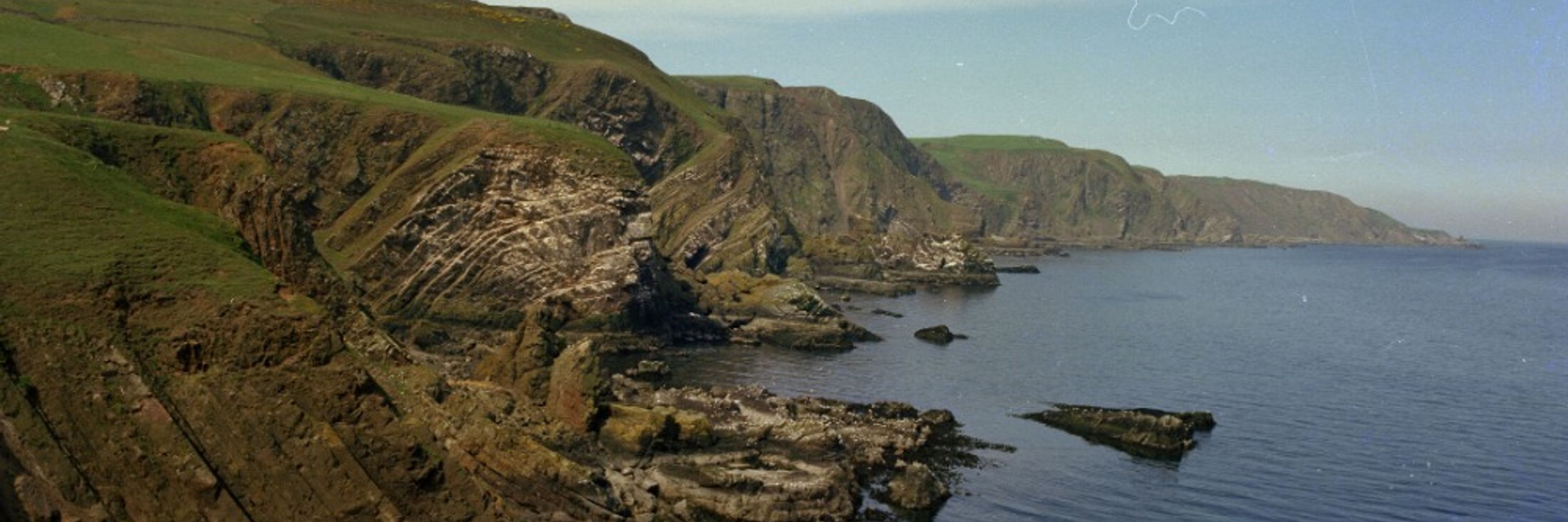
In addition to the 50K maps, BGS has also updated its 10K & 25K maps. BGS Geology 10K and 25K is the most detailed geological dataset we have produced. Around half of the country is now covered with this update, including many urban centres.
www.bgs.ac.uk/news/latest-...
www.bgs.ac.uk/news/latest-...

Latest BGS Geology 50K mapping data launched - British Geological Survey
Some of our most widely used maps have received a major update, including the 1:50 000-scale map series that now includes enhanced coverage of Great Britain.
www.bgs.ac.uk
November 6, 2025 at 12:35 PM
In addition to the 50K maps, BGS has also updated its 10K & 25K maps. BGS Geology 10K and 25K is the most detailed geological dataset we have produced. Around half of the country is now covered with this update, including many urban centres.
www.bgs.ac.uk/news/latest-...
www.bgs.ac.uk/news/latest-...
This includes coverage for approximately 99 per cent of the bedrock and approximately 95 per cent of the superficial deposits across the country.
These geological maps provide crucial information like rock types and faults, forming a valuable resource for a wide range of uses.
These geological maps provide crucial information like rock types and faults, forming a valuable resource for a wide range of uses.

November 6, 2025 at 12:35 PM
This includes coverage for approximately 99 per cent of the bedrock and approximately 95 per cent of the superficial deposits across the country.
These geological maps provide crucial information like rock types and faults, forming a valuable resource for a wide range of uses.
These geological maps provide crucial information like rock types and faults, forming a valuable resource for a wide range of uses.
We were also able to visit the Pineapple museum and park - part of the company's corporate social responsibility programme, helping local communities.
Thank you to our hosts Sumitomo Metal Mining Co., Ltd. and Nickel Asia Corporation for the warm welcome and valuable insights.
Thank you to our hosts Sumitomo Metal Mining Co., Ltd. and Nickel Asia Corporation for the warm welcome and valuable insights.

October 30, 2025 at 3:15 PM
We were also able to visit the Pineapple museum and park - part of the company's corporate social responsibility programme, helping local communities.
Thank you to our hosts Sumitomo Metal Mining Co., Ltd. and Nickel Asia Corporation for the warm welcome and valuable insights.
Thank you to our hosts Sumitomo Metal Mining Co., Ltd. and Nickel Asia Corporation for the warm welcome and valuable insights.
It was great to see the integrated mining and processing site, and the visit showcased the importance of responsible supply chains and best practices — including the rehabilitated tailings storage facility 1, which has been restored to native forest.

October 30, 2025 at 3:15 PM
It was great to see the integrated mining and processing site, and the visit showcased the importance of responsible supply chains and best practices — including the rehabilitated tailings storage facility 1, which has been restored to native forest.