


British Geological Survey
@bgs.ac.uk
A world-leading independent research organisation providing objective, expert geoscientific data, information and knowledge 🌎
BGS is hiring!
We're offering two operations-based roles to help drive forward our research and scientific partnerships:
⚖️ Legal manager //📝 Contract manager
Both roles will be based in Nottingham. Applications will close on 23 November.
www.bgs.ac.uk/about-bgs/wo...
We're offering two operations-based roles to help drive forward our research and scientific partnerships:
⚖️ Legal manager //📝 Contract manager
Both roles will be based in Nottingham. Applications will close on 23 November.
www.bgs.ac.uk/about-bgs/wo...


November 16, 2025 at 10:00 AM
BGS is hiring!
We're offering two operations-based roles to help drive forward our research and scientific partnerships:
⚖️ Legal manager //📝 Contract manager
Both roles will be based in Nottingham. Applications will close on 23 November.
www.bgs.ac.uk/about-bgs/wo...
We're offering two operations-based roles to help drive forward our research and scientific partnerships:
⚖️ Legal manager //📝 Contract manager
Both roles will be based in Nottingham. Applications will close on 23 November.
www.bgs.ac.uk/about-bgs/wo...
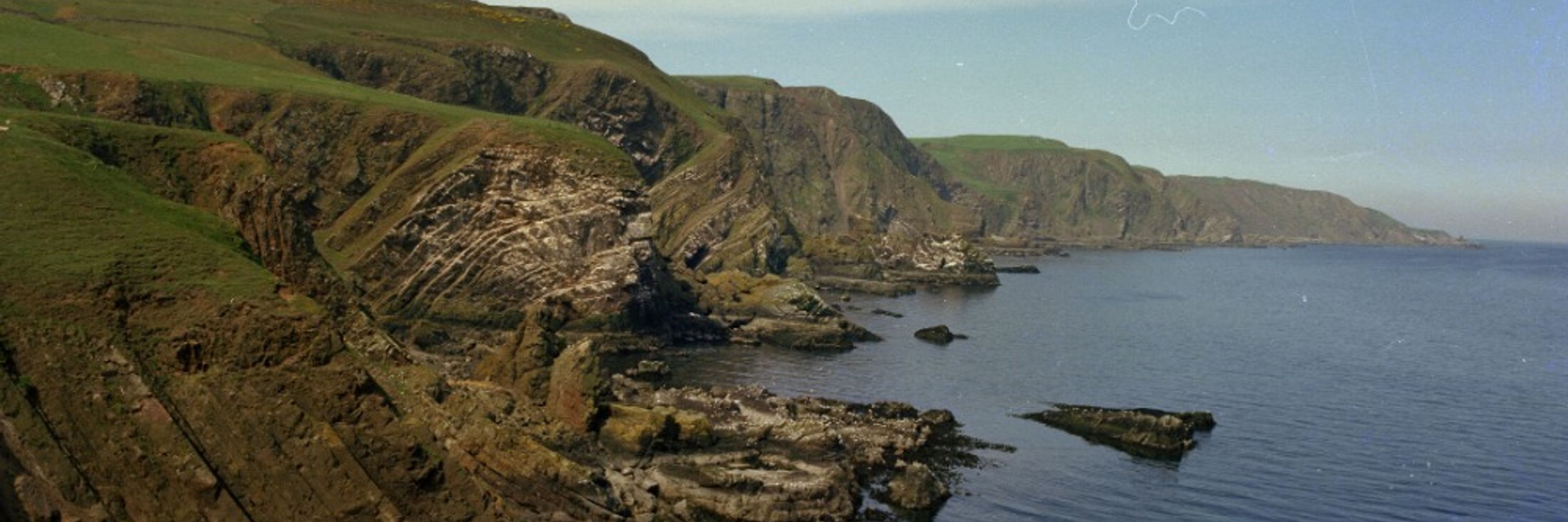
Cutting edge research has shown the potential for mapping thermal changes in the subsurface using sound waves.
Strong seismic arrivals were visible at all depths, providing an encouraging seismic baseline for future thermal testing.
www.bgs.ac.uk/news/first-d...
Strong seismic arrivals were visible at all depths, providing an encouraging seismic baseline for future thermal testing.
www.bgs.ac.uk/news/first-d...

November 13, 2025 at 11:53 AM
Cutting edge research has shown the potential for mapping thermal changes in the subsurface using sound waves.
Strong seismic arrivals were visible at all depths, providing an encouraging seismic baseline for future thermal testing.
www.bgs.ac.uk/news/first-d...
Strong seismic arrivals were visible at all depths, providing an encouraging seismic baseline for future thermal testing.
www.bgs.ac.uk/news/first-d...
Reposted by British Geological Survey
Just back from two weeks in #Zambia as part of a British Geological Survey (BGS) project supporting the #criticalminerals work of the Ministry of Mines and Minerals Development | Zambia Geological Survey Department (GSD). Read all about it here:
www.linkedin.com/posts/clive-...
www.linkedin.com/posts/clive-...

#zambia #criticalminerals #map #zambian #criticalminerals | Clive Mitchell
Just back from two weeks in #Zambia as part of a British Geological Survey (BGS) project supporting the #criticalminerals work of the Ministry of Mines and Minerals Development | Zambia Geological Sur...
www.linkedin.com
November 13, 2025 at 9:35 AM
Just back from two weeks in #Zambia as part of a British Geological Survey (BGS) project supporting the #criticalminerals work of the Ministry of Mines and Minerals Development | Zambia Geological Survey Department (GSD). Read all about it here:
www.linkedin.com/posts/clive-...
www.linkedin.com/posts/clive-...
We have upgraded our geomagnetic forecast today (12 November 2025) to the highest intensity level amid an ongoing solar storm.
Current predictions suggest that the activity will result in potentially the largest solar storm to hit our planet in over two decades.
Current predictions suggest that the activity will result in potentially the largest solar storm to hit our planet in over two decades.
November 12, 2025 at 2:55 PM
We have upgraded our geomagnetic forecast today (12 November 2025) to the highest intensity level amid an ongoing solar storm.
Current predictions suggest that the activity will result in potentially the largest solar storm to hit our planet in over two decades.
Current predictions suggest that the activity will result in potentially the largest solar storm to hit our planet in over two decades.
📰 Why are landslides grinding travel routes to a halt?
BGS engineering geohazard geologist, Dr Claire Dashwood, is featured on the BBC discussing what makes certain parts of the UK more susceptible and why climate change is predicted to increase their frequency.
www.bbc.co.uk/news/article...
BGS engineering geohazard geologist, Dr Claire Dashwood, is featured on the BBC discussing what makes certain parts of the UK more susceptible and why climate change is predicted to increase their frequency.
www.bbc.co.uk/news/article...

Why are landslides shutting down parts of the UK?
The UK is experiencing major landslides but are they caused by extreme weather or something else?
www.bbc.co.uk
November 12, 2025 at 8:18 AM
📰 Why are landslides grinding travel routes to a halt?
BGS engineering geohazard geologist, Dr Claire Dashwood, is featured on the BBC discussing what makes certain parts of the UK more susceptible and why climate change is predicted to increase their frequency.
www.bbc.co.uk/news/article...
BGS engineering geohazard geologist, Dr Claire Dashwood, is featured on the BBC discussing what makes certain parts of the UK more susceptible and why climate change is predicted to increase their frequency.
www.bbc.co.uk/news/article...
🗓️ Artificial Intelligence for Natural Hazards Workshop - Thursday 20th November
Are you an industry or research institution interested in the applications of AI in Earth Observation and natural hazards?
Are you an industry or research institution interested in the applications of AI in Earth Observation and natural hazards?

November 11, 2025 at 12:02 PM
🗓️ Artificial Intelligence for Natural Hazards Workshop - Thursday 20th November
Are you an industry or research institution interested in the applications of AI in Earth Observation and natural hazards?
Are you an industry or research institution interested in the applications of AI in Earth Observation and natural hazards?
Join Gavin Mudd at the Institute of Materials, Minerals & Mining (IOM3)'s M3P3 event on 11 to 12 November 2025.
From AI and circular economy, sustainability & industrial strategy, the event will provide insight, discussion & connection for everyone working in the sector.
Learn more: iom3.info/m3p3
From AI and circular economy, sustainability & industrial strategy, the event will provide insight, discussion & connection for everyone working in the sector.
Learn more: iom3.info/m3p3

November 10, 2025 at 5:16 PM
Join Gavin Mudd at the Institute of Materials, Minerals & Mining (IOM3)'s M3P3 event on 11 to 12 November 2025.
From AI and circular economy, sustainability & industrial strategy, the event will provide insight, discussion & connection for everyone working in the sector.
Learn more: iom3.info/m3p3
From AI and circular economy, sustainability & industrial strategy, the event will provide insight, discussion & connection for everyone working in the sector.
Learn more: iom3.info/m3p3
Thanks to the BBC for speaking to BGS' engineering geologist Ashley Patton about our work monitoring the 'secret' geothermal energy underneath Cardiff, and what it means for homes and businesses locally and nationally.
Click the link to learn more:
www.bbc.co.uk/news/article...
Click the link to learn more:
www.bbc.co.uk/news/article...

'Secret' geothermal energy under Cardiff could heat every home
Untapped underground energy could have potentially huge implications for Cardiff's 124,000 homes.
www.bbc.co.uk
November 9, 2025 at 6:23 PM
Thanks to the BBC for speaking to BGS' engineering geologist Ashley Patton about our work monitoring the 'secret' geothermal energy underneath Cardiff, and what it means for homes and businesses locally and nationally.
Click the link to learn more:
www.bbc.co.uk/news/article...
Click the link to learn more:
www.bbc.co.uk/news/article...
It’s #RadonAwarenessWeek.
The UK Health Security Agency (UKSHA) recommends that radon levels should be reduced in homes where the annual averages is at or above 200 becquerels per cubic metre.
The UK Health Security Agency (UKSHA) recommends that radon levels should be reduced in homes where the annual averages is at or above 200 becquerels per cubic metre.

November 7, 2025 at 2:23 PM
It’s #RadonAwarenessWeek.
The UK Health Security Agency (UKSHA) recommends that radon levels should be reduced in homes where the annual averages is at or above 200 becquerels per cubic metre.
The UK Health Security Agency (UKSHA) recommends that radon levels should be reduced in homes where the annual averages is at or above 200 becquerels per cubic metre.
A selection of our most widely used maps have received a major update. The latest version of BGS Geology 50K now covers the majority of Great Britain plus the Isle of Man, an estimated 236 000 km2.

November 6, 2025 at 12:35 PM
A selection of our most widely used maps have received a major update. The latest version of BGS Geology 50K now covers the majority of Great Britain plus the Isle of Man, an estimated 236 000 km2.
A new paper has called attention to the risk that the Indonesian capital of Jakarta could be subject to a 6.5 magnitude earthquake.
The quake would expose a large number of people, as well as significantly important economic infrastructure, to strong ground shaking.
www.bgs.ac.uk/news/new-res...
The quake would expose a large number of people, as well as significantly important economic infrastructure, to strong ground shaking.
www.bgs.ac.uk/news/new-res...

November 4, 2025 at 11:15 AM
A new paper has called attention to the risk that the Indonesian capital of Jakarta could be subject to a 6.5 magnitude earthquake.
The quake would expose a large number of people, as well as significantly important economic infrastructure, to strong ground shaking.
www.bgs.ac.uk/news/new-res...
The quake would expose a large number of people, as well as significantly important economic infrastructure, to strong ground shaking.
www.bgs.ac.uk/news/new-res...
Reposted by British Geological Survey
A few days of #volcanology fieldwork in Cabo de Gata (Spain) - great submarine volcanics and a really interesting submarine dome collapse/debris avalanche🌋🌞
@bgs.ac.uk
@bgs.ac.uk


November 4, 2025 at 10:09 AM
A few days of #volcanology fieldwork in Cabo de Gata (Spain) - great submarine volcanics and a really interesting submarine dome collapse/debris avalanche🌋🌞
@bgs.ac.uk
@bgs.ac.uk
A weak spot in the Earth’s magnetic field has nearly doubled in surface area since 2014.
BGS Geophysicist Ciarán Beggan appeared on @earthskyscience.bsky.social's podcast to explain why this is happening, and what the consequences might be.
Watch the full episode: www.youtube.com/watch?v=az8K...
BGS Geophysicist Ciarán Beggan appeared on @earthskyscience.bsky.social's podcast to explain why this is happening, and what the consequences might be.
Watch the full episode: www.youtube.com/watch?v=az8K...
November 1, 2025 at 9:01 AM
A weak spot in the Earth’s magnetic field has nearly doubled in surface area since 2014.
BGS Geophysicist Ciarán Beggan appeared on @earthskyscience.bsky.social's podcast to explain why this is happening, and what the consequences might be.
Watch the full episode: www.youtube.com/watch?v=az8K...
BGS Geophysicist Ciarán Beggan appeared on @earthskyscience.bsky.social's podcast to explain why this is happening, and what the consequences might be.
Watch the full episode: www.youtube.com/watch?v=az8K...
On World Cities Day, we are highlighting urban geoscience — the study of the ground beneath our towns and cities — and why understanding this hidden world is essential for building safer and more resilient urban environments.
www.bgs.ac.uk/news/world-c...
www.bgs.ac.uk/news/world-c...


October 31, 2025 at 11:30 AM
On World Cities Day, we are highlighting urban geoscience — the study of the ground beneath our towns and cities — and why understanding this hidden world is essential for building safer and more resilient urban environments.
www.bgs.ac.uk/news/world-c...
www.bgs.ac.uk/news/world-c...
As part of a FCDO Growth Gateway project, BGS scientists and the British Embassy Manila visited Sumitomo Mining's Coral Bay Nickel Corporation and Nickel Asia Rio Tuba Nickel Mining Corporation, to support the development of a Responsible Nickel Roadmap for the Philippines.


October 30, 2025 at 3:15 PM
As part of a FCDO Growth Gateway project, BGS scientists and the British Embassy Manila visited Sumitomo Mining's Coral Bay Nickel Corporation and Nickel Asia Rio Tuba Nickel Mining Corporation, to support the development of a Responsible Nickel Roadmap for the Philippines.
BGS SEISMIC INFORMATION: LEEWARD ISLANDS 27 OCTOBER 2025 11:05 UTC 6.5 MW
The following preliminary information is available for this earthquake:
DATE: 27 October 2025
ORIGIN TIME: 12:38:40s UTC
LAT/LON: 16.530° North / 59.572° West
DEPTH: 10 km
MAGNITUDE: 6.5 Mw
LOCALITY: Leeward Islands
The following preliminary information is available for this earthquake:
DATE: 27 October 2025
ORIGIN TIME: 12:38:40s UTC
LAT/LON: 16.530° North / 59.572° West
DEPTH: 10 km
MAGNITUDE: 6.5 Mw
LOCALITY: Leeward Islands

October 27, 2025 at 2:34 PM
BGS SEISMIC INFORMATION: LEEWARD ISLANDS 27 OCTOBER 2025 11:05 UTC 6.5 MW
The following preliminary information is available for this earthquake:
DATE: 27 October 2025
ORIGIN TIME: 12:38:40s UTC
LAT/LON: 16.530° North / 59.572° West
DEPTH: 10 km
MAGNITUDE: 6.5 Mw
LOCALITY: Leeward Islands
The following preliminary information is available for this earthquake:
DATE: 27 October 2025
ORIGIN TIME: 12:38:40s UTC
LAT/LON: 16.530° North / 59.572° West
DEPTH: 10 km
MAGNITUDE: 6.5 Mw
LOCALITY: Leeward Islands
BGS scientists have been investigating how Volcán de Fuego in Guatemala builds up & collapses, producing fast-moving pyroclastic flows.
Using field mapping, drone surveys & geomagnetic analysis, they are uncovering how unstable volcanic material moves, & how to better anticipate future collapses.
Using field mapping, drone surveys & geomagnetic analysis, they are uncovering how unstable volcanic material moves, & how to better anticipate future collapses.

October 27, 2025 at 12:36 PM
BGS scientists have been investigating how Volcán de Fuego in Guatemala builds up & collapses, producing fast-moving pyroclastic flows.
Using field mapping, drone surveys & geomagnetic analysis, they are uncovering how unstable volcanic material moves, & how to better anticipate future collapses.
Using field mapping, drone surveys & geomagnetic analysis, they are uncovering how unstable volcanic material moves, & how to better anticipate future collapses.
We are in the process of developing new methods for capturing & representing artificial ground information. To ensure that this is as useful and beneficial as possible to the stakeholder community we want to hear your thoughts.
Please take the survey here:
www.bgs.ac.uk/news/bgs-art...
Please take the survey here:
www.bgs.ac.uk/news/bgs-art...

October 23, 2025 at 4:20 PM
We are in the process of developing new methods for capturing & representing artificial ground information. To ensure that this is as useful and beneficial as possible to the stakeholder community we want to hear your thoughts.
Please take the survey here:
www.bgs.ac.uk/news/bgs-art...
Please take the survey here:
www.bgs.ac.uk/news/bgs-art...
Five new sensors being installed across the UK will provide full national coverage of the magnetic field for the first time.
The quantum magnetometer sensors will improve our understanding of extreme magnetic storms and associated effects on national infrastructure.
www.bgs.ac.uk/news/uk-scie...
The quantum magnetometer sensors will improve our understanding of extreme magnetic storms and associated effects on national infrastructure.
www.bgs.ac.uk/news/uk-scie...

October 22, 2025 at 9:08 AM
Five new sensors being installed across the UK will provide full national coverage of the magnetic field for the first time.
The quantum magnetometer sensors will improve our understanding of extreme magnetic storms and associated effects on national infrastructure.
www.bgs.ac.uk/news/uk-scie...
The quantum magnetometer sensors will improve our understanding of extreme magnetic storms and associated effects on national infrastructure.
www.bgs.ac.uk/news/uk-scie...
BGS SEISMIC INFORMATION: PUBIL, PERTH & KINROSS 20 OCTOBER 2025 17:06 UTC 3.7 ML
The following preliminary information is available for this earthquake:
DATE: 20 October 2025
ORIGIN TIME: 17:06.43s UTC
LAT/LON: 56.551° North / 4.552° West
GRID REF: 243kmE / 743kmN
DEPTH: 2.6 km
MAGNITUDE: 3.7 Ml
The following preliminary information is available for this earthquake:
DATE: 20 October 2025
ORIGIN TIME: 17:06.43s UTC
LAT/LON: 56.551° North / 4.552° West
GRID REF: 243kmE / 743kmN
DEPTH: 2.6 km
MAGNITUDE: 3.7 Ml
October 20, 2025 at 6:10 PM
BGS SEISMIC INFORMATION: PUBIL, PERTH & KINROSS 20 OCTOBER 2025 17:06 UTC 3.7 ML
The following preliminary information is available for this earthquake:
DATE: 20 October 2025
ORIGIN TIME: 17:06.43s UTC
LAT/LON: 56.551° North / 4.552° West
GRID REF: 243kmE / 743kmN
DEPTH: 2.6 km
MAGNITUDE: 3.7 Ml
The following preliminary information is available for this earthquake:
DATE: 20 October 2025
ORIGIN TIME: 17:06.43s UTC
LAT/LON: 56.551° North / 4.552° West
GRID REF: 243kmE / 743kmN
DEPTH: 2.6 km
MAGNITUDE: 3.7 Ml
BGS SEISMIC INFORMATION: PUBIL, PERTH & KINROSS 20 OCTOBER 2025 16:29 UTC 2.7 ML
The following preliminary information is available for this earthquake:
DATE: 20 October 2025
ORIGIN TIME: 16:29.16s UTC
LAT/LON: 56.5380° North / 4.550° West
GRID REF: 243kmE / 741kmN
DEPTH: 2.6 km
MAGNITUDE: 2.7 ML
The following preliminary information is available for this earthquake:
DATE: 20 October 2025
ORIGIN TIME: 16:29.16s UTC
LAT/LON: 56.5380° North / 4.550° West
GRID REF: 243kmE / 741kmN
DEPTH: 2.6 km
MAGNITUDE: 2.7 ML
October 20, 2025 at 6:07 PM
BGS SEISMIC INFORMATION: PUBIL, PERTH & KINROSS 20 OCTOBER 2025 16:29 UTC 2.7 ML
The following preliminary information is available for this earthquake:
DATE: 20 October 2025
ORIGIN TIME: 16:29.16s UTC
LAT/LON: 56.5380° North / 4.550° West
GRID REF: 243kmE / 741kmN
DEPTH: 2.6 km
MAGNITUDE: 2.7 ML
The following preliminary information is available for this earthquake:
DATE: 20 October 2025
ORIGIN TIME: 16:29.16s UTC
LAT/LON: 56.5380° North / 4.550° West
GRID REF: 243kmE / 741kmN
DEPTH: 2.6 km
MAGNITUDE: 2.7 ML
BGS SEISMIC INFORMATION: PUBIL, PERTH & KINROSS 20 OCTOBER 2025 07:25 UTC 3.3 ML
The following preliminary info is available for this earthquake:
DATE: 20 October 2025
ORIGIN TIME: 07:25.18s UTC
LAT/LON: 56.5460° North / 4.5670° West
GRID REF: 242kmE / 742kmN
DEPTH: 2.6 km
MAGNITUDE: 3.3 Ml
The following preliminary info is available for this earthquake:
DATE: 20 October 2025
ORIGIN TIME: 07:25.18s UTC
LAT/LON: 56.5460° North / 4.5670° West
GRID REF: 242kmE / 742kmN
DEPTH: 2.6 km
MAGNITUDE: 3.3 Ml
October 20, 2025 at 8:56 AM
BGS SEISMIC INFORMATION: PUBIL, PERTH & KINROSS 20 OCTOBER 2025 07:25 UTC 3.3 ML
The following preliminary info is available for this earthquake:
DATE: 20 October 2025
ORIGIN TIME: 07:25.18s UTC
LAT/LON: 56.5460° North / 4.5670° West
GRID REF: 242kmE / 742kmN
DEPTH: 2.6 km
MAGNITUDE: 3.3 Ml
The following preliminary info is available for this earthquake:
DATE: 20 October 2025
ORIGIN TIME: 07:25.18s UTC
LAT/LON: 56.5460° North / 4.5670° West
GRID REF: 242kmE / 742kmN
DEPTH: 2.6 km
MAGNITUDE: 3.3 Ml
The Geological Survey of Northern Ireland (GSNI) were recognised at the RegioStars awards this week. Their Atlantic Geohazard Risk Management (AGEO) project, supported by Interreg Atlantic Area, emerged with two awards.
www.bgs.ac.uk/news/gsni-pr...
www.bgs.ac.uk/news/gsni-pr...

October 17, 2025 at 10:45 AM
The Geological Survey of Northern Ireland (GSNI) were recognised at the RegioStars awards this week. Their Atlantic Geohazard Risk Management (AGEO) project, supported by Interreg Atlantic Area, emerged with two awards.
www.bgs.ac.uk/news/gsni-pr...
www.bgs.ac.uk/news/gsni-pr...
BGS' GeoIndex viewer has been given a major upgrade and is available as a beta release.
It includes core geological data layers, such as 625K- and 50K-scale digital geological mapping and borehole datasets, to allow for focused user testing.
Visit the app: geoindex.bgs.ac.uk?_ga=2.224738...
It includes core geological data layers, such as 625K- and 50K-scale digital geological mapping and borehole datasets, to allow for focused user testing.
Visit the app: geoindex.bgs.ac.uk?_ga=2.224738...

October 16, 2025 at 2:26 PM
BGS' GeoIndex viewer has been given a major upgrade and is available as a beta release.
It includes core geological data layers, such as 625K- and 50K-scale digital geological mapping and borehole datasets, to allow for focused user testing.
Visit the app: geoindex.bgs.ac.uk?_ga=2.224738...
It includes core geological data layers, such as 625K- and 50K-scale digital geological mapping and borehole datasets, to allow for focused user testing.
Visit the app: geoindex.bgs.ac.uk?_ga=2.224738...
BGS scientists are investigating how Volcán de Fuego in Guatemala builds up and collapses, producing fast-moving pyroclastic flows.
Through field mapping, drone surveys and geomagnetic analysis, the team aim to better understand and anticipate future collapses.
🔗: www.bgs.ac.uk/news/fieldwo...
Through field mapping, drone surveys and geomagnetic analysis, the team aim to better understand and anticipate future collapses.
🔗: www.bgs.ac.uk/news/fieldwo...

October 13, 2025 at 5:30 PM
BGS scientists are investigating how Volcán de Fuego in Guatemala builds up and collapses, producing fast-moving pyroclastic flows.
Through field mapping, drone surveys and geomagnetic analysis, the team aim to better understand and anticipate future collapses.
🔗: www.bgs.ac.uk/news/fieldwo...
Through field mapping, drone surveys and geomagnetic analysis, the team aim to better understand and anticipate future collapses.
🔗: www.bgs.ac.uk/news/fieldwo...