


Truckee and N. Tahoe Fire, Weather, & Safety
@truckeentahoefws.bsky.social
BlueSky addition for the original FB Group serving North Lake Tahoe and Truckee
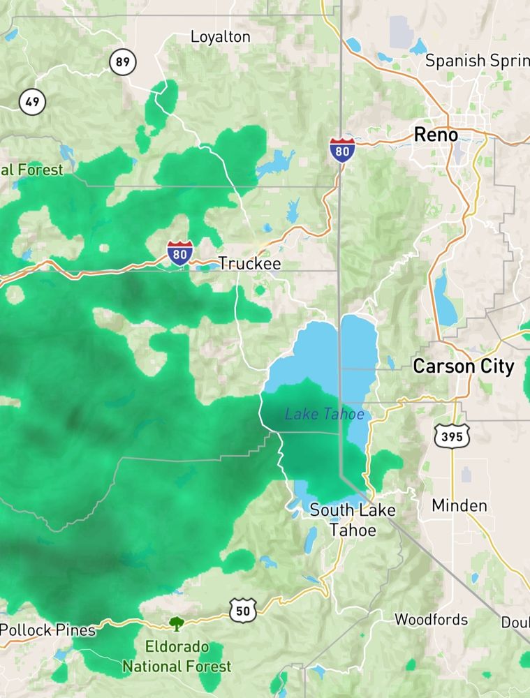
Winter storm warning for coverage area Tuesday 10pm to Friday 10am


December 23, 2025 at 6:30 AM
Winter storm warning for coverage area Tuesday 10pm to Friday 10am


December 21, 2025 at 7:15 PM
Reposted by Truckee and N. Tahoe Fire, Weather, & Safety
CAL FIRE has doubled the number of acres treated for wildfire prevention — surpassing 800,000 acres, announced California State Fire Marshal Daniel Berlant during Friday’s meeting of the Wildfire and Forest Resilience Task Force.
Learn more: WildfireTaskForce.org
Learn more: WildfireTaskForce.org


December 13, 2025 at 1:18 AM
CAL FIRE has doubled the number of acres treated for wildfire prevention — surpassing 800,000 acres, announced California State Fire Marshal Daniel Berlant during Friday’s meeting of the Wildfire and Forest Resilience Task Force.
Learn more: WildfireTaskForce.org
Learn more: WildfireTaskForce.org
Reposted by Truckee and N. Tahoe Fire, Weather, & Safety

This is an excellent & balanced overview of recently increased pace of planetary warming. There's much we still don't know, & there are almost certainly multiple causes, but possibility (not confirmed, but real) that these trends portend higher climate sensitivity is disquieting.

In a new article over at Carbon Brief, I explore why the past three years – 2023, 2024, and 2025 – have been exceptionally warm. The main culprits turn out to be a combination of El Nino and internal variability, declining aerosols, and a strong solar cycle: www.carbonbrief.org/...

December 13, 2025 at 4:52 AM
This is an excellent & balanced overview of recently increased pace of planetary warming. There's much we still don't know, & there are almost certainly multiple causes, but possibility (not confirmed, but real) that these trends portend higher climate sensitivity is disquieting.
300 characters makes it hard to get all the caveats about projections and snow levels in. So, hopefully these images will tell the story. Wet but warm atmospheric river probability high starting Dec 19th, possibly hanging out off and on through the 27th. Stay tuned!


December 13, 2025 at 6:30 AM
300 characters makes it hard to get all the caveats about projections and snow levels in. So, hopefully these images will tell the story. Wet but warm atmospheric river probability high starting Dec 19th, possibly hanging out off and on through the 27th. Stay tuned!
Reposted by Truckee and N. Tahoe Fire, Weather, & Safety

Days have been colder in San Francisco than Lake Tahoe lately. What’s going on? Explaining temperature inversions:
December 10, 2025 at 12:15 AM
Days have been colder in San Francisco than Lake Tahoe lately. What’s going on? Explaining temperature inversions:
Good information
Weather pattern change to put CA in a precarious position post-Thanksgiving. Maps shows the "standard deviation" (spread) amongst weather models Dec. 1. There is more uncertainty about the atmospheric pattern over CA than anywhere else in the Northern Hemisphere! Could be cold/wet or less cold & dry


November 22, 2025 at 7:46 AM
Good information
Winter Weather Watch issued


November 11, 2025 at 2:52 AM
Winter Weather Watch issued
Multiple Rx burns coupled with humidity, cold air aloft, and fairly low cloud cover is trapping smoke close to the ground. Showers should clear out this afternoon into the evening. Saturday brings our next storm of mostly rain, 7k to 8k ft snow levels and 100+ mph winds to the ridge line.


October 22, 2025 at 7:02 PM
Multiple Rx burns coupled with humidity, cold air aloft, and fairly low cloud cover is trapping smoke close to the ground. Showers should clear out this afternoon into the evening. Saturday brings our next storm of mostly rain, 7k to 8k ft snow levels and 100+ mph winds to the ridge line.
Reposted by Truckee and N. Tahoe Fire, Weather, & Safety
Spooky season is here, but fire safety is no trick. 🎃
While decorating for Halloween, remember to:
🕸 Keep exits clear
🕯 Keep décor away from candles, heaters, and lights
🚨 Double-check your smoke alarms
A safe home is the best treat of all.
#CALFIRE #HalloweenSafety #FireSmart #SpookySeason
While decorating for Halloween, remember to:
🕸 Keep exits clear
🕯 Keep décor away from candles, heaters, and lights
🚨 Double-check your smoke alarms
A safe home is the best treat of all.
#CALFIRE #HalloweenSafety #FireSmart #SpookySeason

October 21, 2025 at 1:41 PM
Spooky season is here, but fire safety is no trick. 🎃
While decorating for Halloween, remember to:
🕸 Keep exits clear
🕯 Keep décor away from candles, heaters, and lights
🚨 Double-check your smoke alarms
A safe home is the best treat of all.
#CALFIRE #HalloweenSafety #FireSmart #SpookySeason
While decorating for Halloween, remember to:
🕸 Keep exits clear
🕯 Keep décor away from candles, heaters, and lights
🚨 Double-check your smoke alarms
A safe home is the best treat of all.
#CALFIRE #HalloweenSafety #FireSmart #SpookySeason
Reposted by Truckee and N. Tahoe Fire, Weather, & Safety

The Weather Prediction Center (WPC) has updated their Day 3-7 Hazards Outlook. See more at www.wpc.ncep.noaa.gov/threats/thre...

October 21, 2025 at 9:15 PM
The Weather Prediction Center (WPC) has updated their Day 3-7 Hazards Outlook. See more at www.wpc.ncep.noaa.gov/threats/thre...
Biggest weather stories for our area:
-Nice from now till late Friday, but possibility of high winds Thursday and Friday
-Very slight chance of snow Friday night
-Decent weekend
-Another chance of rain/snow Monday/Tuesday
❄️🌞🌧️
-Nice from now till late Friday, but possibility of high winds Thursday and Friday
-Very slight chance of snow Friday night
-Decent weekend
-Another chance of rain/snow Monday/Tuesday
❄️🌞🌧️
October 7, 2025 at 3:33 AM
Biggest weather stories for our area:
-Nice from now till late Friday, but possibility of high winds Thursday and Friday
-Very slight chance of snow Friday night
-Decent weekend
-Another chance of rain/snow Monday/Tuesday
❄️🌞🌧️
-Nice from now till late Friday, but possibility of high winds Thursday and Friday
-Very slight chance of snow Friday night
-Decent weekend
-Another chance of rain/snow Monday/Tuesday
❄️🌞🌧️
Weather changes on the horizon. This weekend looks lovely then we cool off and have increased chances of rain starting Monday. Most models are leaning towards Monday afternoon into Tuesday being heaviest. One model is teasing snow a week out, but that's unlikely. Enjoy the weekend!


September 26, 2025 at 9:16 PM
Weather changes on the horizon. This weekend looks lovely then we cool off and have increased chances of rain starting Monday. Most models are leaning towards Monday afternoon into Tuesday being heaviest. One model is teasing snow a week out, but that's unlikely. Enjoy the weekend!
Reposted by Truckee and N. Tahoe Fire, Weather, & Safety
What items should be in your emergency kit? These 10 basic supplies could be life saving in the event of a weather emergency. Check your kit!
For more information about being prepared before inclement weather strikes visit weather.gov/safety.
#NationalPreparednessMonth #PreparednessStartsAtHome
For more information about being prepared before inclement weather strikes visit weather.gov/safety.
#NationalPreparednessMonth #PreparednessStartsAtHome
September 26, 2025 at 3:19 PM
What items should be in your emergency kit? These 10 basic supplies could be life saving in the event of a weather emergency. Check your kit!
For more information about being prepared before inclement weather strikes visit weather.gov/safety.
#NationalPreparednessMonth #PreparednessStartsAtHome
For more information about being prepared before inclement weather strikes visit weather.gov/safety.
#NationalPreparednessMonth #PreparednessStartsAtHome
Reposted by Truckee and N. Tahoe Fire, Weather, & Safety
How the first major Pacific storm of the rainy season will impact California www.sfchronicle.com/weather-fore...

How the first major Pacific storm of the rainy season will impact California
Officials forecast more than 2 inches of rain near the California-Oregon border. The highest peaks could get dusted with snow. Thunderstorms are possible throughout Northern California.
www.sfchronicle.com
September 26, 2025 at 8:36 PM
How the first major Pacific storm of the rainy season will impact California www.sfchronicle.com/weather-fore...
Feeling Fall in the air! 🍂
Thunderstorm chances start today and extend through Thursday with high temps around 60ish. Lows are dipping into the 30s. It's time to break out the layers. Of the next 5 to 7 days, Saturday looks to be the best outside day!!!!
Thunderstorm chances start today and extend through Thursday with high temps around 60ish. Lows are dipping into the 30s. It's time to break out the layers. Of the next 5 to 7 days, Saturday looks to be the best outside day!!!!

September 9, 2025 at 10:21 PM
Feeling Fall in the air! 🍂
Thunderstorm chances start today and extend through Thursday with high temps around 60ish. Lows are dipping into the 30s. It's time to break out the layers. Of the next 5 to 7 days, Saturday looks to be the best outside day!!!!
Thunderstorm chances start today and extend through Thursday with high temps around 60ish. Lows are dipping into the 30s. It's time to break out the layers. Of the next 5 to 7 days, Saturday looks to be the best outside day!!!!
Much lower probabilities of storms today but not completely out of the picture. Tomorrow starts a lovely looking Labor Day weekend.
Locals summer (IYKYK) starts off with temps around 80, lows in the 40s. Slight chances for thunderstorms return Wednesday into Thursday, but we'll see.
Locals summer (IYKYK) starts off with temps around 80, lows in the 40s. Slight chances for thunderstorms return Wednesday into Thursday, but we'll see.

August 28, 2025 at 7:44 PM
Much lower probabilities of storms today but not completely out of the picture. Tomorrow starts a lovely looking Labor Day weekend.
Locals summer (IYKYK) starts off with temps around 80, lows in the 40s. Slight chances for thunderstorms return Wednesday into Thursday, but we'll see.
Locals summer (IYKYK) starts off with temps around 80, lows in the 40s. Slight chances for thunderstorms return Wednesday into Thursday, but we'll see.

August 24, 2025 at 11:02 PM
Widespread lightning within striking distance of Donner Lake, Prosser, Boca, and Stampede reservoirs. Find shelter indoors if at all possible

August 24, 2025 at 10:50 PM
Widespread lightning within striking distance of Donner Lake, Prosser, Boca, and Stampede reservoirs. Find shelter indoors if at all possible
FYI Sierra County
share.watchduty.org/i/61381?ts=1...
share.watchduty.org/camera/1720?...
Other small fires have been reported and listed as contained in Nevada, Placer, and Sierra counties
share.watchduty.org/i/61381?ts=1...
share.watchduty.org/camera/1720?...
Other small fires have been reported and listed as contained in Nevada, Placer, and Sierra counties

August 24, 2025 at 9:52 PM
FYI Sierra County
share.watchduty.org/i/61381?ts=1...
share.watchduty.org/camera/1720?...
Other small fires have been reported and listed as contained in Nevada, Placer, and Sierra counties
share.watchduty.org/i/61381?ts=1...
share.watchduty.org/camera/1720?...
Other small fires have been reported and listed as contained in Nevada, Placer, and Sierra counties
Yesterday (first picture) produced widespread thunderstorm. Today, most activity is to the north and south of the area. Unsettled weather continues through WEDNESDAY. Flood watch in effect until 9pm for the area
forecast.weather.gov/MapClick.php...
forecast.weather.gov/MapClick.php...


August 24, 2025 at 9:50 PM
Yesterday (first picture) produced widespread thunderstorm. Today, most activity is to the north and south of the area. Unsettled weather continues through WEDNESDAY. Flood watch in effect until 9pm for the area
forecast.weather.gov/MapClick.php...
forecast.weather.gov/MapClick.php...
Here's the forecast for the week ahead along with the long term trends. There's some disagreement regarding showers in the future so keep an eye on that.
Overall, not too unexpected for August. Have a great week
Overall, not too unexpected for August. Have a great week


August 18, 2025 at 7:10 PM
Here's the forecast for the week ahead along with the long term trends. There's some disagreement regarding showers in the future so keep an eye on that.
Overall, not too unexpected for August. Have a great week
Overall, not too unexpected for August. Have a great week
Chances of afternoon t-storms today through Saturday with highest probabilities on Friday and Saturday. If out on the water or up on the high peaks, keep an eye on the sky.
Temps will be in the 70s creeping towards 80 today and tomorrow then trending down a bit with a rebound Monday.
Temps will be in the 70s creeping towards 80 today and tomorrow then trending down a bit with a rebound Monday.

July 23, 2025 at 6:41 PM
Chances of afternoon t-storms today through Saturday with highest probabilities on Friday and Saturday. If out on the water or up on the high peaks, keep an eye on the sky.
Temps will be in the 70s creeping towards 80 today and tomorrow then trending down a bit with a rebound Monday.
Temps will be in the 70s creeping towards 80 today and tomorrow then trending down a bit with a rebound Monday.
Why so hazy? Smoke
:( We're unfortunately in the path of smoke travel right now so hazy skies and "meh" air quality continues. (Ignore the outlier in Incline Village. It's been flagged)
:( We're unfortunately in the path of smoke travel right now so hazy skies and "meh" air quality continues. (Ignore the outlier in Incline Village. It's been flagged)


July 14, 2025 at 9:33 PM
Why so hazy? Smoke
:( We're unfortunately in the path of smoke travel right now so hazy skies and "meh" air quality continues. (Ignore the outlier in Incline Village. It's been flagged)
:( We're unfortunately in the path of smoke travel right now so hazy skies and "meh" air quality continues. (Ignore the outlier in Incline Village. It's been flagged)
Cool down starts tomorrow! It's currently hitting 90 or more in Truckee. Tomorrow we go back to mid 80s then low 80s by Friday.
Air quality remains moderate, though it was a bit thick earlier today. Expect the same tomorrow unless fire intensity increases for the fires to our WNW.
Stay hydrated!
Air quality remains moderate, though it was a bit thick earlier today. Expect the same tomorrow unless fire intensity increases for the fires to our WNW.
Stay hydrated!


July 14, 2025 at 9:17 PM
Cool down starts tomorrow! It's currently hitting 90 or more in Truckee. Tomorrow we go back to mid 80s then low 80s by Friday.
Air quality remains moderate, though it was a bit thick earlier today. Expect the same tomorrow unless fire intensity increases for the fires to our WNW.
Stay hydrated!
Air quality remains moderate, though it was a bit thick earlier today. Expect the same tomorrow unless fire intensity increases for the fires to our WNW.
Stay hydrated!